Cornelia Schmidt, Swiss Reinsurance Company, Zurich, Switzerland
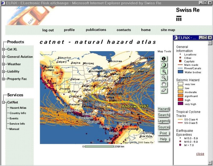
CatNet enables users to gain a fast overview of natural perils by means of an electronic atlas. It provides easy access to up-to-date maps, showing the most relevant perils worldwide. The tool helps to estimate more accurately the risks for any location on earth, which is particularly useful for the insurance industry.
Swiss Re (Swiss Reinsurance Company) - one of the world leading international reinsurance companies - insures and supports insurance companies around the globe from more than 70 branches. The insurers transfer to the reinsurer either parts or all of those risks which they do not want to cover themselves.
In 1999, insured losses caused by natural catastrophes amounted to USD 24.4 billion. This figure presented insurers with their second highest claims burden ever, second only to that incurred from Hurricane "Andrew" in 1992. The seven billion dollar loss resulting from storms and earthquakes was the main cause. Both this ominous development and the globalization of the insurance industry are creating increasing demand for global information on natural hazards and ways of insuring against them.
With CatNet (Catastrophe Network), an internet service offering clients comprehensive information on natural hazards worldwide, Swiss Re's Reinsurance and Risk division aims to meet this demand. Since last summer, users have been able to access in-depth information electronically by means of an interactive natural hazard atlas.
CatNet is composed of an electronic atlas, country-specific insurance information and loss event data. It enables clients to gain an overview of the most relevant perils and estimate more accurately the risks for any location on earth within minutes.
Using the internet address on www.elrix.com clients have to register to use CatNet or any other products available on the Swiss Re ELectronic RIsk EXchange portal. After verification, a username and password are send to the client, giving access to CatNet for an eight-week trial period free of charge.
The electronic atlas powered by ArcIMS 3.0 consists of the following map tools, which enables the user to work interactively.
Map tools and buttons
![]() I-tool, identification of almost all available
datasets
I-tool, identification of almost all available
datasets
![]() World extend, returns to world extend
World extend, returns to world extend
![]() ZoomIn, click or drag a rectangle to zoom in
ZoomIn, click or drag a rectangle to zoom in
![]() ZoomOut, click or drag a rectangle to zoom out
ZoomOut, click or drag a rectangle to zoom out
![]() Pan, move in a desired direction
Pan, move in a desired direction
![]() Eraser, erase a label resulting from a specified
search
Eraser, erase a label resulting from a specified
search
To display and query natural hazard information, the user uses the following buttons:
![]()
Opens a new window and displays a list with all hazard data available
Natural perils
Historic event collection on:
and
![]()
A new frame opens, allowing the user to search:
After the appropriate selection the feature is labeled
![]()
Displays the key of the current topic(s)
![]()
Displays sources and processing methods
![]()
Prints the desired map area including key and source
![]()
Describes the various tools and buttons
Different data sources have been chosen for orientation. We mainly use data from Infotech Europe as well as Esri datasets and a world map of Chalk Butte. Most of the hazard data have been processed by the Swiss Re's Cat Perils group (hazard and GIS specialists) which is also responsible for the maintenance.
CatNet currently offers detailed information about country-specific insurance conditions for Australia, Canada, Belgium, France, Germany, Israel, Japan, Mexico, the Netherlands, the UK and the US. The country pages offer in-depth information about the insurance situation, natural catastrophes and economic figures, which are difficult to acquire from other sources. New countries are added on a regular basis and are developed jointly with the market divisions.
CatNet also supplies information on natural catastrophe events
(fatalities, losses etc) and their respective impact on insurance (based on sigma
figures). A comprehensive manual, glossary and a short demo give the non-registered user
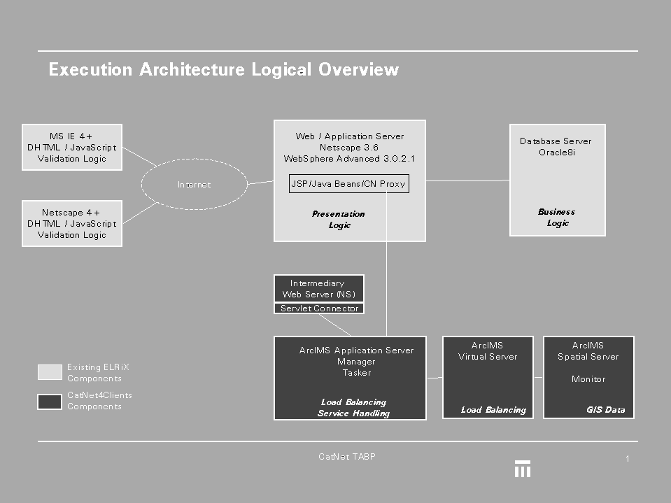
detailed information on CatNet's service offer.Architecture and technical specifications
Swiss Re's first internet platform ELRiX
(ELectronic RIsk eXhange) was chosen as the CatNet platform. We based it on the ELRiX
architecture, which is based, in turn, on IBM WebSphere running on Solaris, and to use the
standard Servlet connector of ArcIMS 3.0. To fulfill Swiss Re's security requirements for
transactions, an additional servlet proxy bean - a mini-servlet engine - had to be built
to host the "insecure" ArcIMS servlet.
By way of example, let's say an insurance company located in Germany has a facultative risk, located in Baldwin, Lousiana, USA, and the company needs information on potential natural hazards.
One way to get the required information is to go directly to the Hazard Atlas and use the location finder (search button) for Baldwin, Lousiana. By choosing the desired city from more than half a million locations, the user will zoom in automatically to Lousiana and the city is labelled. The hazard button will display all available perils, which the user can either alternate among or cascade, depending on the topic. Activating seismic hazard with earthquakes, for example, shows clearly that Baldwin is not very much exposed to seismic hazard. The user chooses flood and pushing the key button opens a window with the corresponding key for the active topic(s). The next hazard topic "Tropical Cyclone tracks" shows that Baldwin is highly exposed to Cyclones. With the i-tool button, the user can query each individual track as well as Baldwin itself to get a risk rate in permille as a first indication. Additionally, the Cresta SubZone information has been added to locations where applicable.
Activating the source button not only shows information on the data supplier, but also explains data processing and links specific terms to a comprehensive glossary, which is part of the manual.
The next generation of CatNet will include additional data for
search and orientation as well as more natural hazard data stored in ArcSDE, such as
European winterstorms, hail etc. The functionality will be increased by features such as
geographic analysis tools, geocoding and input of latitude and longitude. Also planned is
to offer our clients to send their portfolios based on Zip Codes, CRESTA Zones and Subzones or
administrative units and to visualise the distribution of values. The expansion of CatNet is part of a server system called CATOS (CAT
Online System). CATOS will offer a comprehensive geographic database with GIS technology
(ArcSDE, ArcIMS), the visualisation of risk information in maps and advanced CAT rating
engines to support all Swiss Re internal applications with GIS-related information. Cornelia Schmidt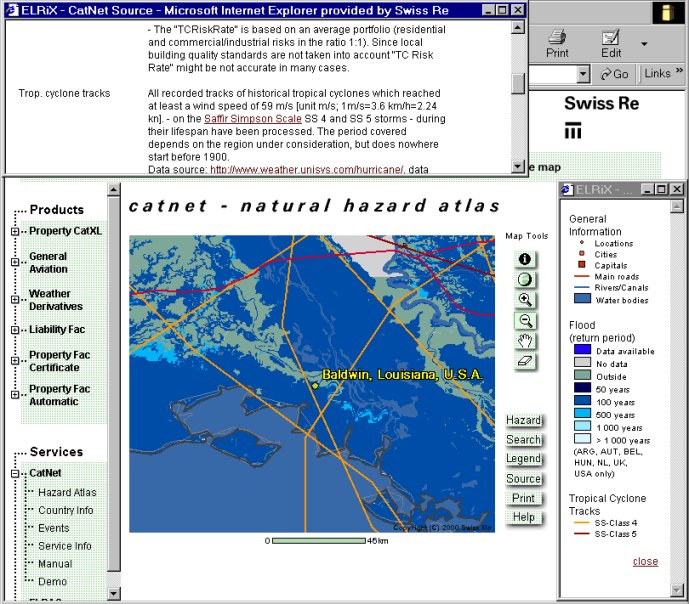
Outlook
GIS Specialist
Swiss Re
Cat Perils
Mythenquai 50/60
8022 Zurich
Switzerland
Phone: ++41-1-285 6148
Fax: ++41-1-285 4243
Email: Cornelia_Schmidt@swissre.com
http://www.swissre.com
http://www.elrix.com