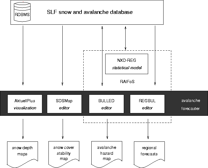
Figure 1: GIS applications for the avalanche warning service.
Stoffel, A., Brabec, B., Stöckli, U.
The Swiss Federal Institute for Snow and Avalanche Research (SLF) is responsible for avalanche warning in Switzerland since 1945. Starting in the early 90s the SLF has developed a wide variety of GIS-based tools to support avalanche forecasters. These tools are used for visualizing measurements from manual and automatic networks, constructing maps of the current avalanche hazard or compiling maps of avalanche accidents and damages. The paper gives an overview of these applications and shows how GIS is coupled to relational databases (Oracle) and statistical packages (S-Plus).
Avalanche warning has been a key task of the Swiss Federal Institute for Snow and Avalanche Research in Davos (SLF) since it has been set up over half a century ago. Since 1996 the way avalanche warning is done has gone through a major change. The project Avalanche Warning Switzerland 2000 [Russi et al.(1998)Russi, Ammann, Brabec, Lehning, and Meister] has introduced "computer-aided avalanche forecasting" in order to cope with the increasing demand for more and more precise avalanche forecasts. The state of avalanche warning in Switzerland before this effort has been documented by [Meister(1994)]. Already at that time, GIS tools were in use to generate map based products. [Stucki et al.(1998)Stucki, Ammann, Meister, and Brabec] have developed a 3-level concept (i.e. national, regional, local level) for avalanche warning in Switzerland that is in use since then. The daily national avalanche forecast, the Swiss-wide collection of input data for avalanche warning and several auxiliary products are the main focus of the national level. In addition, nearly all Swiss alpine regions are covered by regional avalanche bulletins. The data of automatic snow and weather stations, detailed weather forecasts, the feedback from local avalanche forecasters and information from models like SNOWPACK [Lehning et al.(1999)Lehning, Bartelt, Brown, Russi, Stöckli, and Zimmerli] and NXD-REG [Brabec and Meister(2001)] are compiled to the regional avalanche bulletins. At the local level SLF is supporting the authorities who are responsible for local avalanche warnings and preventive measures by providing specific software [Gassner et al.(2000)Gassner, Birkeland, Etter, and Leonard].
The SLF snow and avalanche database, an Oracle database system, stores all data gathered for the avalanche warning service at SLF. The database contains measurements from manual and automatic networks, snow profiles, avalanche observations and feedback from local avalanche forecasters as well as data from models calculated on national, regional and local level. The forecasters at the avalanche warning service use a wide range of tools to analyze and visualize these data. This paper describes the main GIS applications developed at SLF.
Figure 1: GIS applications for the avalanche warning service.
The diagram in figure 1 shows the application framework from the GIS point of view. The forecaster accesses the data in the SLF snow and avalanche database through modular GIS applications like AktuellPlus, Raifos and SDSMap. All GIS applications are developed with ArcView and run in a UNIX environment. Avenue scripts are used to build up the ArcView projects from scratch preventing problems with corrupt project files and performance. Additional non GIS software like InfoBox [Russi et al.(1998)Russi, Ammann, Brabec, Lehning, and Meister], an information system designed for Swiss avalanche specialists and Microsoft Office applications are used in the Windows environment.
To visualize the large amount of data compiled in the snow and avalanche database a GIS based viewer (AktuellPlus) was developed using ArcView. AktuellPlus is an application designed for the national level. It supports the avalanche forecaster to get a fairly quick overview over the current or past weather, snow and avalanche conditions in the Swiss Alps.
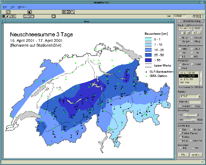
Figure 2: User interface of AktuellPlus. The example shows the 3 day sum of new-snow depth in the time period from 15 April 2001 to 17 April 2001.
Figure 2 shows the user interface of AktuellPlus. The dialog on the right side enables the user to select date and time, a combination of data collection networks available for the point of time selected, the measurement parameters based on the selections made before and how the map will be displayed. Color as well as black and white maps for fax output are supported. The map can contain labeled points, symbols or a raster resp. a vector interpolation. Some complex symbols for avalanche activity were designed in Corel Draw and imported as true type font into ArcView. The map title will be constructed automatically according to the map contents and the users preference of detail. The resulting map may be sent via menu selection to a network printer or may be published to internet (current examples are available during winter season, e.g. snow depth http://www.slf.ch/avalanche/hsr-dec.html or new snow depth http://www.slf.ch/avalanche/hn1-dec.html), a fax delivery system or InfoBox. AktuellPlus is designed as an interactive application but can also be used for batch processing of maps that are produced and published on regular basis.
RAIFoS (Regional Avalanche Information and Forecasting System) is a computer based system that contains three complementary software packages: a GIS-based editor (BULLED) for constructing a map showing the estimated avalanche hazard, a statistical model (NXD-REG) that forecasts the avalanche hazard for the regional level and an editor (REGBUL) to edit the Swiss regional avalanche forecasts for 6 regions.
The bulletin-graph-editor (BULLED) is an application to construct and visualize past, current and future avalanche hazard estimates for the national and regional level. Figure 3 shows the user interface of BULLED. In the operational sense, these estimates are still given by experienced specialists at the SLF avalanche warning service, who are working with empirical tools to fix the avalanche hazard estimates.
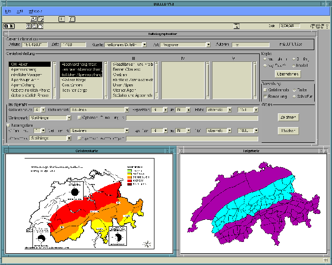
Figure 3: User interface of bulletin-graph-editor (BULLED).
BULLED has been implemented using ArcView as interface and map production tool and the Oracle database for storing all hazard estimate information. Maps can be constructed in two ways: Either a region is selected first via its name or through a map selection and the hazard for that area is estimated afterwards or vice versa. To make the map-based bulletins compatible to the text-based national avalanche forecast a division of Switzerland into sub-areas of about 50-1000 km² has been derived. These sub-areas were formed by dividing the principal political regions of Switzerland (e.g. cantons) with the basic meteorological and climatological areas of the Swiss Alps. The window "Teilgebiete" in the lower right of figure 3 shows these 100 sub-areas that can be selected individually from the map or via dynamic listboxes in the user interface. Besides the names of the sub-areas 70 additional geographic terms have been introduced and organized into five levels. These terms can be presented as an acyclic directed graph and are stored in the relational database.
For each sub-area the hazard estimation is given by the hazard level, according to the European avalanche hazard scale, type of danger, aspect, altitude and type of endangered terrain part. This information is shown on the maps by so called "hazard-plots". The result of the map construction is shown in the left bottom window. Color as well as black and white maps for fax output are supported. The dissemination of the resulting product is highly integrated. It may be sent as map via menu selection to all channels indicated for AktuellPlus as well as in form of a short text to a location service (via Wireless Application Protocol WAP).
BULLED is in operational use at SLF since winter 1998/99. The database contains about 1600 avalanche hazard estimates by now. During three years about 540 avalanche hazard maps for Switzerland have been produced and published (current examples are available during winter season, e.g. http://www.slf.ch/avalanche/nbk-dec.html).
The abbreviation NXD-REG stands for Next-X-Days-Regional. It is a nearest neighbors based model that has been generalized to the task of regional avalanche forecasting [Brabec and Meister(2001)]. Besides the data gathered through the manual observation network BULLED has been used to construct a database of the last 10 years of avalanche hazard estimates. Both databases are integrated into the SLF snow and avalanche database. The software implementation of NXD-REG is based on a combination of database (Oracle), GIS (ArcView) and statistical software (S-Plus) that runs in batch mode. All data, results and parameters of the model are stored within the database. The statistical software is used to calculate all statistical estimates, to implement the NXD-approach for each station and to compare several statistical approaches. ArcView produces all maps and prints them automatically to a network printer (figure 4).
The results of 60 nearest neighbor calculations based on the Swiss manual observation network are read from the SLF snow and avalanche database into ArcView and then interpolated to a map of hazard values. These hazard values are averaged by the 100 sub-areas defined in BULLED and reclassified to a second map of hazard levels. Figure 4 shows a typical result. The results of NXD-REG are directly written to the database of BULLED which allows the avalanche forecaster to quickly access and evaluate them as a suggestion for a new avalanche forecast.
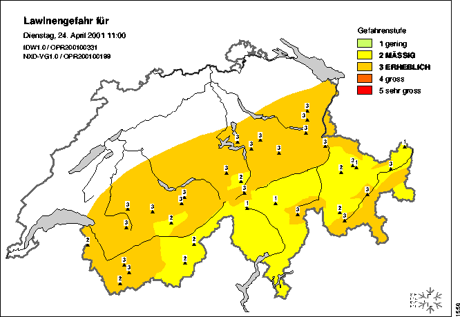
Figure 4: Result of NXD-REG for 24 April 2001.
The Regional Bulletin-editor REGBUL is used to efficiently construct regional avalanche forecasts for Switzerland. Figure 5 shows an example of a regional forecast.
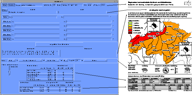
Figure 5: User interface of regional bulletin editor (REGBUL).
The user interface of REGBUL (figure 5) is due to historical reasons built in IDL. The structure is similar to the document that is published. At the top, one can find the input fields for general text information. The weather forecast from MeteoSwiss national weather service in form of pictograms as well as a table with data of automatic stations are imported automatically. The hazard estimation which is the main part of the product is done using BULLED (figure 3). Consistency for the hazard estimations of sub-areas that appear in several regional forecasts is guaranteed. The resulting document is created using ArcView via remote procedure call (RPC). ArcView reads the intermediate file produced by the IDL interface and the hazard estimate from BULLED to compose the final document. The regional bulletin is completed by adding "hazard-plots" and printed or published to internet (current examples are available during winter season, e.g. http://www.slf.ch/avalanche/rb50-dec.html), a fax delivery system or InfoBox.
Snowpack stability information is crucial for assessing the avalanche danger [Schweizer and Wiesinger(2001)]. The forecaster's objective is to detect weak layers, crusts etc. overlain by a potential slab structure, to follow their changes with time, and hence to assess current stability and the probability of slab avalanche release in the near future. Snow cover structure is investigated directly by digging pits and examining the stratigraphy at the exposed wall. Layering, crystal type and size, snow hardness and temperature, as well as snow density are registered, preferably combined with a stability test like the rutschblock test [Föhn(1987)]. All stratigraphy data is graphically represented as a so-called snow profile. Snow profiles are taken on regular basis by the local observers and by SLF staff. About 50 profiles from the whole area of the Swiss Alps are twice a month classified to derive spatial stability patterns. The classification into one of five stability classes (from very poor to very good) is partly based on the ram hardness profile [Quervain and Meister(1987)]. The derived snowpack stability map (SDSMap) is a GIS application built to analyze current and past snow profile data and to compile a snow cover stability map. Figure 6 shows the user interface of SDSMap.
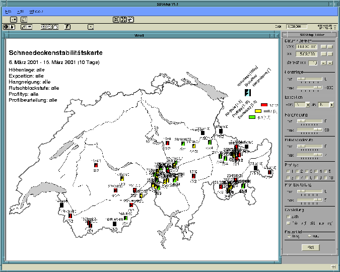
Figure 6: User interface of SDSMap. The example shows the snow cover stability map for the time period from 6 March 2001 to 15 March 2001 with labeled symbols.
Through the dialog on the right side the user can select the snow profiles for a date and time period, elevation, aspect and slope angle, rutschblock score, type of hardness profile and stability class. Then all snow profile data of the given time period is read from the SLF snow and avalanche database and the snow pit location is entered as event theme to the map view. Optional selections (e.g. elevation range) are performed on the theme and the snow pit location is displayed with a symbol showing generalized snow hardness type and stability. The symbol is hotlinked to a picture showing the detailed snow profile. Symbol labels may be displayed to show the main snow profile parameters on the map. Scale dependent zooming changes the base map and enables the user to analyze clusters of snow profiles. For publishing purpose the symbol labels are removed and text boxes may be added to the map to further explain the estimation of snowpack stability. The resulting map is published to the internet as image map including the hotlinked pictures (current examples are available during winter season at http://www.slf.ch/avalanche/spmap-de.html). The sensitive hotlink zones are constructed by calculating Thiessen also known as Voronoi polygons for the snow pit locations. All areas within these polygons are nearer to the location with which they are constructed than to any other snow pit locations. This calculation assures that all map area is covered by hotlinked zones and even an inaccurate mouse click on a snow profile symbol will return the snow profile picture.
Detailed information about the amount of requests from SLF have been collected over the last 5 years in order to demonstrate the public interest in our products.
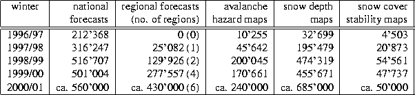
Table 1: Requests of SLF products between winter 1996/97 and winter 2000/2001.
In winter 1996/97 the text-based national avalanche forecasts (e.g. http://www.slf.ch/avalanche/bulletin-de.html) were requested about 200'000 times. This number has increased up to 560'000 in winter 2000/2001. At the same time the requests for regional forecasts increased to 430'000 (table 1). Winter 1998/99 has been an extreme winter in Switzerland [SLF(2000)]. This is also reflected in the number of requests which increased extraordinary. We also noticed that during extreme situations information presented in graphic form is heavily requested and well suited for the public. All SLF products have been requested approx. 2'000'000 times by internet, fax, InfoBox or telephone during winter 2000/2001. Approx. 80% of the information have been disseminated by internet.
Spatial representation of avalanche activity - potential and observed - is crucial for local avalanche forecasting. It answers some of the key questions: where and how often do avalanches occur, of what size and under which conditions? A data set including 14 years of detailed mapping of avalanche occurrence in the surroundings of the village of Zuoz in the Engadine valley (eastern Swiss Alps) formed the base of a study done at SLF using a GIS approach [Stoffel et al.(1998)Stoffel, Meister, and Schweizer]. All medium-sized and larger avalanches have been mapped by the local snow and avalanche observer. They were digitized using ArcInfo and linked to the daily snow and avalanche observations. Thus the avalanche activity and its spatial distribution could be analyzed, visualized and a classification for avalanche size and avalanche activity proposed. The extent of the study area was chosen through a visibility analysis considering the possible movement of the avalanche observer on the road along the valley. Figure 7 shows the study area and the spatial distribution of frequency of avalanche occurrence. The avalanche area decreases strongly with higher frequency of avalanche occurrence.
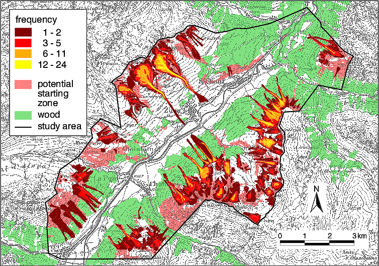
Figure 7: Spatial distribution of frequency of avalanche occurrence over the 14 year period of avalanche observation. Digital Map Data PM 100 © Swiss Federal Office of Topography (BA013495).
Analysis of the relation of daily avalanche activity to weather, snow and snow cover revealed a wide variety of contributory factors. Even for large amounts of new snow, snow-cover conditions prior to snowfall or temperature evolution might decide on the extent of the avalanche activity. The GIS approach linking weather, snow and snow cover data with spatial avalanche activity is an excellent tool for a future decision support system.
Damages caused by avalanches are recorded by several local, regional and national organizations. In 1994 SLF started a big effort to collect avalanche damage and accident data from all known sources to build a detailed Swiss-wide database. The SLF Avalanche Damage and Accident Database contains up to now approx. 13000 avalanches that caused damage to goods, nature or human life. This data is used for visualization and analysis purposes in many research and consulting projects.
For a spatial analysis all records where exported from the original FileMaker database and read into ArcView. ArcInfo coverages were constructed from the location information for starting and end point of the avalanches. These data sets were probability checked with DTM data and the spatial parameters were corrected in the original database if needed.
Figure 8: Avalanche frequency based on a 1 km raster overlaid with a simple graphical representation of avalanche path and size. Digital Map Data PM 100 © Swiss Federal Office of Topography (BA013495).
[Gruber(2001)] presents the process of avalanche hazard mapping in Switzerland. At this point only a short summary is given. Since the middle of the 1990's GIS technology in combination with new numerical simulation methods are developed at SLF in order to improve the quality of avalanche hazard zone calculations and to construct avalanche hazard maps that indicate endangered zones in settled areas. GIS is used to identify and analyze avalanche release zones, to determine friction parameters along the avalanche path, to manage digital terrain data and finally to plot the hazard maps. Run out distance, speed and deposits of avalanches were calculated using different numerical simulation models that are embedded together with the GIS features directly in a unique AML-powered graphical user interface.
In this paper several GIS applications for the avalanche warning service and risk management are described. During the last years we experienced that keeping the applications small and simple leads to advantages in developing and maintaining them.
ArcView proved to be a good choice to develop the GIS applications for the avalanche warning service due to its dialog capability and easy customization of the user interface. Database integration unfortunately is rather slow but allows access to the SLF snow and avalanche database and therefore to analyze and visualize a large amount of data through easy to use dialogs. The ArcView GIS capabilities are used for interpolation, raster to vector transformation, shapefile editing, and so forth. A co-kriging interpolation method would be an asset. The dissemination of maps and map-based products to various channels is highly integrated in our applications.
The GIS applications are well accepted at SLF and led to big improvements and performance enhancements in the process of data analysis, visualization and presentation. The interest in our map-based products increased heavily with the growing public access to the internet.
For next year we will be experimenting with geostatistical interpolation methods to improve the quality of our snow depth maps. We plan to focus on the comparison of output from ArcGIS Geostatistical Analyst, S-Plus and new procedures developed at SLF. Within BULLED several analysis tools to compare different hazard assessments will be developed. NXD-REG will be extended by input data from automatic weather stations, snow cover stability data and output from NXD2000. For the next years it is planed to actually cover all areas of the Swiss Alps with regional bulletins. Furthermore several other approaches for statistical models will be applied to the task of regional and local avalanche forecasting.
The authors gratefully acknowledge the assistance and advice of Roland Meister, Jürg Schweizer, Thomas Wiesinger and Paul Föhn.
Andreas Stoffel
WSL Swiss Federal Institute for Snow and Avalanche Research (SLF),
CH-7260 Davos Dorf,
Switzerland
phone: +41+81-417 02 43
e-mail: stoffel@slf.ch
Bernhard Brabec
WSL Swiss Federal Institute for Snow and Avalanche Research (SLF),
CH-7260 Davos Dorf,
Switzerland
phone: +41+81-417 01 56
e-mail: brabec@slf.ch
Urs Stöckli
WSL Swiss Federal Institute for Snow and Avalanche Research (SLF),
CH-7260 Davos Dorf,
Switzerland
phone: +41+81-417 01 57
e-mail: urs.stoeckli@slf.ch