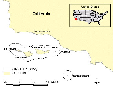
Figure 1. Study Area
The Channel Islands – Spatial Support and Analysis Tool (CI-SSAT) was developed by the National Oceanic and Atmospheric Administration (NOAA) Coastal Services Center and the NOAA Channel Islands National Marine Sanctuary. The sanctuary is involved in a joint federal and state process to develop alternatives for siting marine reserves (i.e., creating "no-take" or restricted access areas) around the sanctuary area. A working group of local stakeholders was formed to use consensus-built criteria and the best available science and socioeconomic information to reach its conclusions. A geographic information system–based tool was developed to support stakeholders in participatory problem solving by providing an intuitive visualization and query mechanism to investigate how different siting locations would impact various resources and areas of recreational and commercial use.
CI-SSAT was developed with Environmental Systems Research Institute (Esri®) ArcView® 3.2 and Microsoft® Visual Basic® 6.0 software, and provides the framework to compile and visualize all the spatial data sets and criteria crucial to siting a marine reserve. CI-SSAT uses a simple algorithm to compute the suitability of a site to become a marine reserve. For this calculation, the working group's participants can weight or assign percentages to each criterion based on their particular perspectives. The group can then begin to visualize various management options, weight the quantitative and qualitative benefits and costs of various alternatives, and model the impacts of one alternative relative to another. The tool was successfully used in a public forum in September 2000. Plans are underway to transfer the process and tool to other marine protected areas that are involved in similar community focused processes.
The National Oceanic and Atmospheric Administration (NOAA) Channel Islands National Marine Sanctuary (CINMS), located off the coast of Santa Barbara, California, is conducting a 5-year review of its management plan. An important issue that has evolved from the process is the need to site marine ecological reserves (i.e., areas dedicated to preserving, enhancing, and rebuilding habitat diversity) within the sanctuary boundary. In order to address all aspects of this often contentious issue, the sanctuary, along with the California Department of Fish and Game, developed a joint stakeholder-driven process to weigh the impact of an ecological reserve. The use of a geographic information system (GIS), as a decision-support tool, was considered an important support element to the process. Figure 1 provides a map of the sanctuary boundary and the interior Channel Islands.
Figure 1. Study Area
A marine reserve working group, composed of 20 diverse and representative stakeholders, was formed in early spring of 1999. It includes local resource users (i.e., commercial fishermen, recreational fishermen, and recreational diving groups), conservationists, and local, state, and federal government representatives. The goal of the working group is to consider the benefits of creating a marine reserve within CINMS and, if deemed beneficial, determine the optimal location or locations. Moreover, the group was charged with using consensus-derived criteria and the best available science and socioeconomic information to support its decision. In addition to the working group, a science panel and a socioeconomic team were formed to support the working group by providing information on the biological and economic impacts of marine reserves.
The science panel is comprised of experts in marine reserve ecological science. The panel was chosen to include, among other things, local knowledge, diverse disciplines, and a geographic balance across the state of California. The socioeconomic team is comprised of two economists from the NOAA National Ocean Service Special Projects Office, who provided expertise in the economics of marine reserves. This particular economic team had recently gained valuable experience in a marine reserve analysis at the NOAA Florida Keys National Marine Sanctuary. Both the science panel and the socioeconomic team are charged with developing and compiling all the data sets that are needed to make both an ecological and socioeconomic analysis of the sanctuary. The working group is scheduled to recommend a preferred alternative by December 2000.
The sanctuary staff considered GIS an ideal tool to support a group-based decision by assisting the working group in visualizing the complex socioeconomic and ecological data that were made available. Group-based GIS provides a framework that supports the understanding of complex spatial relationships among variables and can support participatory decision-making and problem-solving activities. An important requirement for the use of a GIS-based tool was that it be designed in a way that allowed members of the working group to follow all aspects of the spatial analysis process. The sanctuary wanted to provide the working group members an intuitive visualization and query mechanism that would allow them to determine the effects of siting the reserve in different locations. The tool was not envisioned to circumvent any negotiation process among members, but to serve as a common framework that allows the data sets to be viewed, queried, and used to make decisions. The NOAA Coastal Services Center was asked to assist the sanctuary in the design and development of this decision-support tool.
The collaborative effort between the Center and the sanctuary resulted in the Channel Islands – Spatial Support and Analysis Tool (CI-SSAT). CI-SSAT has been developed with Environmental Systems Research Institute (Esri®) ArcView® 3.2 and Microsoft® Visual Basic® 6.0 software. These products were chosen because they are common software used by the coastal and marine resource management community. The tool uses a simple algorithm to rank the suitability of various marine reserve locations. Different dialog boxes allow a working group member to weight or assign percentages to a criterion value and then view the spatial results. The results are displayed as a raster or grid map with high numerical values representing areas that are more suitable for a marine reserve based on the criteria and the weighting scheme chosen. In addition to looking at the outcomes of the weighting schemes, the user has the ability to query some of the basic science and socioeconomic data sets to determine how possible locations could influence certain industries or conserve certain resources. A summary of the decision process can be seen in Chart 1.
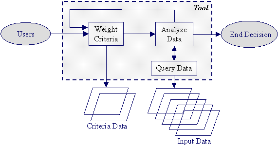
Chart 1. Decision Process Flow Chart
All data sets are referenced to a common study area base map consisting of a grid of 1-nautical-mile resolution. These grids were derived from the California Department of Fish and Game 10-nautical-mile fishing blocks used for regulatory purposes and commonly used by others working in the region. The 10-nautical-mile units were divided into 1-nautical-mile units. A more refined resolution for the data sets could not be used, due to limitations in the socioeconomic data. The studies done on the commercial and recreational industries within the area were limited to a 1-nautical-mile spatial resolution, and therefore, to be consistent, the tool uses a 1-nautical-mile cell size for all of its data sets.
In addition to a common base map, the tool uses a raster data format. The raster data format matches much of the existing data for the region, which simplifies the development of the tool’s algorithm. The science panel’s and socioeconomic team's data layers were rasterized, and the planning units were used as the common extent for all the data layers. Using a common extent forces all the data to have the same origin, cell size, and spatial limit. Figure 2 shows the planning units in relation to the sanctuary boundary and the Channel Islands. The sanctuary boundary contains 1,535 planning units, equaling 1,535 square nautical miles of study area.
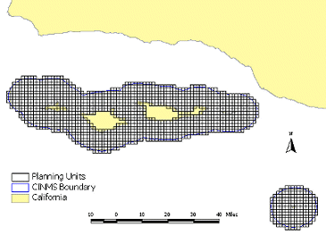
Figure 2. Planning Units
Four main categories of data sets were created for the working group to use in its analysis: evaluation criteria data, habitat data, socioeconomic data, and anecdotal or ancillary data.
Evaluation criteria data are, in general, indicators of future outcomes or result measures. Each evaluation criterion data layer is a compilation of many individual data sets representing the likelihood that the evaluation criterion's goal will be met. Each cell uses a common ranking unit that represents how well it fulfills the goal. This common unit allows for analysis among criteria layers (Malczewski, 1999 ). CI-SSAT's probability ranking values range between 0 and 100, where 100 represents the highest ranking or location for that criterion. Based on input from the working group, two criteria were developed: ecological and socioeconomic.
Ecological Criteria
The ecological criterion data layer was developed by the science panel based on an ecological annealing model* that determined the potential for the most diverse habitat per unit area. The goals and objectives, given to the science panel from the working group, focused on habit diversity as the primary parameter in determining an ecologically sound marine reserve. The ecological model focused on habitat diversity and used the planning units as its area of interest. The science panel used various data sets to derive its results. These data included sediment types, bathymetry, emergent rocks, submerged rocky features, submarine canyons, marine plants, seabird rookeries, and pinniped haulouts, among others.
The results of the annealing model runs were values between 0 and 1 for each planning unit. The value was based on the diversity of habitats within the unit, with a value of 1 representing a higher ranking, or more diverse habitat. The resultant data were multiplied by 100 to fit with the criteria ranking scale of 0 to 100. Again, a value of 100 represents a cell with the most diverse habitat and the most favorable location for a marine reserve, if habitat biodiversity is the only consideration.
* Simulated annealing is a Monte Carlo approach for reducing the number of variables in an analysis by creating a few new variables from several initial ones. These new variables, in addition to being fewer in number, are uncorrelated with each other. These simulations for analyzing spatial data are beyond the scope of this paper and the reader is referred to Possingham, 2000)
Socioeconomic Criteria
As specified by the socioeconomic team, the socioeconomic criterion data were originally designed to represent economic analysis values or dependency indicators of the consumptive industries in the area. Due to complications with data collection, the true economic impact analysis models could not be created and used in time for the working group's schedule. Therefore, the socioeconomic criterion had to be based on the raw revenue and usage data layers. These data layers included total revenue per species fished, including squid and kelp harvesting, and total usage by recreational, commercial, and private fishermen and divers.
Because each of the different industry values was represented in a different unit of measure, a straight summation to determine the total revenue per grid cell was not possible. Therefore, a process to normalize each data layer and create a sum was devised. Each individual data set was normalized from 0 to 100, and the values for all the different industries were summed. The summation was then renormalized so that the values again ranged from 0 to 100. The criterion values no longer represented raw revenue numbers, but rather relative ranking indicating areas of high income or usage.
In a further complication, to meet the objectives of the working group, the scale of the criterion values had to be reversed to represent low socioeconomic impacts as desirable, or highly ranked, for the reserve siting purposes. Areas with high economic activity would then be ranked at the low, or less desirable, end of the scale. In effect, the reversing of scale resulted in low revenue locations being more highly ranked in selection of marine reserves.
Thus, while both the socioeconomic and the ecological criterion data layers have cell values between 0 and 100, the high end of the scale represents low economic activity and high biodiversity for reserve siting purposes. Table 1 summarizes the ranking values for each criterion.
|
Criteria |
Ranking Values |
|
|
0 |
100 |
|
|
Ecological |
Areas of poor biodiversity |
Areas of good biodiversity |
|
Socioeconomic |
Areas with high economic activity |
Areas with low economic activity |
Table 1. Ranking Values for the Criteria Data Layers
In addition to the criteria data, the science panel’s and socioeconomic team's raw data sets were available to the working group. The science panel data sets consisted mostly of habitat data such as bottom sediment types (e.g., hard and soft), coastline (e.g., sandy and rocky), marine and mammal densities, kelp, surfgrass, and eelgrass areas. In addition to the basic habitat layers, the science panel also provided the top ranking iterations of their model runs for the working group to visualize. The socioeconomic team provided aggregate fishing revenue, kelp harvesting and squid fishing revenue, recreational commercial diving usage, recreational private diving usage, recreational commercial fishing usage, and recreational private fishing usage. These data were available to the working group to visualize and query, and to assist them in understanding all aspects of the resources under consideration.
In addition, other anecdotal or ancillary data were made available. These data were based on informal interviews with local citizens, mostly fishermen, who have lived and fished in the Channel Islands area for many years. Their knowledge of historical fish habitats and breeding grounds was noted on a map and added to CI-SSAT. In addition, any notice of decline or growth in numbers of key species of fish in the area was also captured.
CI-SSAT is based on a simple weighting algorithm, usually referred to as simple additive weighting or weighted linear combination, that combines the criteria data layers as follows:
a1x1 + a2x2 + a3x3 + … = S
where an is the weight value that sums to 1.0, xn is the criterion data cell bearing a value between 0 and 100, and S is the resultant output data cell value ranging between 0 and 100. A high ranking value represents a suitable area for a marine reserve based on the chosen weights and criteria data (Malczewski, 1999).
CI-SSAT is run within an ArcView environment. It focuses on three main areas of functionality: weighting the criteria, performing queries, and creating exclusion areas.
Each user begins the siting process by individually selecting a weight or rank for each criterion based on his or her perspective. The tool allows different weighting schemes to be created and processed, providing a quick interactive method to evaluate different scenarios, using the Criteria Weighting Window. Figure 3 provides a picture of the interactive Criteria Weighting Window. The user selects a Weight Value between 0 and 100, with a total no greater than 100 when all weights are summed together. For the purposes of the algorithm, the numbers are then divided by 100 to standardize them between 0 and 1 for processing.
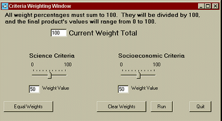
Figure 3. Criteria Weighting Window
CI-SSAT multiplies the weight value by the criteria data grid, and then summarizes all the weighted criteria grids together using raster addition. Each cell in the resultant grid represents a ranking value that indicates its potential for being a marine reserve based on the criteria and the weights selected. The values range between 0 and 100, with the greater values indicating a higher potential for a marine reserve. Figure 4 provides an example of the criteria data layers view as seen by the user.
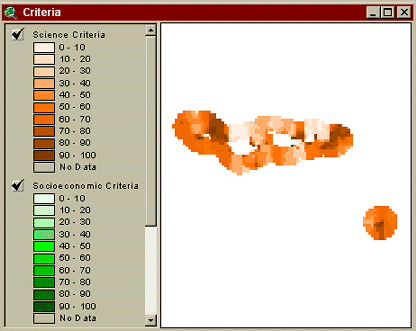
Figure 4. Criteria View within CI-SSAT
After the criteria and weight values are selected and processed, an output map is displayed representing areas with a high potential for marine reserve selection for those weights and criteria (see Figure 5).
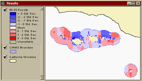
Figure 5. Results from 50 Percent Ecological Criteria and
50 Percent Socioeconomic Criteria Weighting
In addition to looking at the outcome of the weights, the user may query the individual ecological and socioeconomic data layers to determine the impacts of a possible marine reserve location on an industry or resource.
To facilitate discovery and understanding of all user experiences, CI-SSAT has two sets of predefined query functions. The ecological queries focus on information provided by the science panel and on habitat types. Data such as kelp habitat, surfgrass, eelgrass, coastline geomorphology, benthic sediments, and bird and mammal densities can be queried. The socioeconomic queries focus on the consumptive industries operating in the waters near the Channel Islands. Revenues from commercial fishing, and kelp and squid harvesting, as well as industry usage data on recreational, commercial, and private fishing and diving can all be analyzed.
A fundamental part of the decision-support functions of CI-SSAT is the ability to reach the data behind the resultant criteria layer and perform quick and easy queries. The user has the ability to select or draw a proposed site, then determine what will be influenced or what will be conserved in that location. Figure 6 demonstrates how a user might draw a query polygon and perform an analysis for commercial industries. The Query Results window returns a table of values for the analyzed area and compares these values to the total CINMS study area. In another example, a user could examine an area and determine how much surfgrass is being preserved, while at another location look at minimizing impacts on squid fishermen. Performing these queries helps the user to determine relative impact estimates. These values support the negotiation process in site selection by using quantitative information in addition to personal judgments.
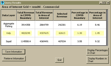
Figure 6. Query Results: Commercial Fishing, Kelp Harvesting, and Squid Harvesting Data
The exclusion areas function allows a user to select areas that should be excluded from further analysis. Possible examples of exclusion areas are those that are already protected, sensitive areas that should be avoided in the negotiation process, or areas where a user chooses not to consider marine reserve locations. These areas can be brought in from other software, in ArcView shapefile format, or drawn on the screen and converted to an exclusion grid format. If this function is used, CI-SSAT will automatically exclude those areas from analysis, and they will not be displayed in the results when the next weighting exercise is performed.
A workshop held in Santa Barbara, California ,on September 26 and 27, 2000, was the first opportunity for CI-SSAT to be used by the working group. The goal of the two-day meeting was to develop alternatives for a marine reserve site(s). The meetings focused on two areas, information dissemination and boundary creation.
To aid in participant understanding at all levels; day one focused on data dissemination. The science panel and the socioeconomic team presented the methodologies used to create the criteria data layers. In addition, the science panel explained its underlying theories regarding minimum size and location requirements for marine reserve siting, and clarified input data layers and output variables from their ecological models. The socioeconomic team presented information on data collection techniques and the significance of the revenue and usage values for the industry data.
The second day of the meeting used CI-SSAT as support for the group-based decision-making process and focused on determining and analyzing alternatives. Initially, a demonstration of CI-SSAT was given to the working group. This demonstration served to familiarize the working group members with the interface and functionality of the tool and to allow them to ask questions about its operation and supporting data.
The working group members were then divided into four subgroups. The facilitation team made an attempt to balance the four groups with a diverse spectrum of participant experience. A member from each individual stakeholder category (e.g., conservationist, government, or fisherman) was assigned to each group so that no group would be dominated by one opinion base. Each group was charged with the task of developing three different alternatives. CI-SSAT was available for each individual subgroup to use to support its decision by helping in the visualization of the various data and attributes. A technical facilitator familiar with all aspects of CI-SSAT operation was assigned to each subgroup to prevent the group members from becoming focused on the computer operations and not on the process. Each group chose three standard weighting schemes to begin their analysis. These were 25 percent ecological/75 percent socioeconomic; 75 percent ecological/25 percent socioeconomic; and 50 percent ecological/50 percent socioeconomic. The results of each weighting scheme were viewable by the group members.
As some participants were more comfortable using paper maps to draw initial boundaries, printed maps of the CINMS boundary, the Channel Islands, and the planning grid were provided. If paper maps were used, those areas were then entered into CI-SSAT by the technical facilitator. In turn, these areas were queried and results returned to the participants to provide support in analyzing the impacts on the local ecology and economy.
At the conclusion of the session, nine alternative marine reserve boundaries were determined. It was interesting to note that the size and location of the options were greatly influenced by the subgroup dynamics. Some groups cooperated and consulted with other groups about their options. Other groups, however, had members with strong opinions, and compromising proved more difficult. The tool was used mainly for visualizing and querying the data. Most of the groups spent considerable time using CI-SSAT to query alternative strategies with the pre-set queries to understand how their individual decisions would affect other constituent groups.
The subsequent meeting on October 18, 2000, provided additional time for the working group to refine alternatives. At this meeting, the working group was divided into five homogenous constituent subgroups consisting of commercial fishing interests, environmental interests, recreational interests, government interests, and anyone else who did not fit into the other groups. Each subgroup was tasked with developing a single alternative. The tool was primarily used as a visualization mechanism to allow the working group to evaluate the five options. In addition to the group’s evaluations, the five options were analyzed in detail by CINMS staff for size and preliminary socioeconomic impacts. These analyses and results from the October 18 meeting were compiled and presented to the working group at the November 15, 2000, meeting.
At the request of the socioeconomic team, the final options were based solely on the ecological criteria, and excluding the socioeconomic data from the solution. The members of the socioeconomic team determined that they could not perform a thorough impact analysis unless the ecological criteria were taken into account beforehand. A socioeconomic analysis will be conducted at a later date to determine the impact the final alternatives will have on the economy. In addition, the members of the scientific working group will perform their analysis on the solutions to determine how well their goal of maximizing habitat biodiversity was met. Once those studies are concluded, the working group will examine the findings and finalize its selection of alternatives.
There are a number of process steps that must be conducted before any marine reserve can be officially located. First, the working group must make its recommendations to the CINMS Advisory Council. This is scheduled to take place in December of 2000. After reviewing the results, the CINMS Advisory Council must then make its recommendations to the CINMS, which will forward the requests to the California State Department of Fish and Game and the NOAA National Marine Sanctuary Program (NMSP) office. At that time, the legal process may proceed on the official designation.
Initially, the NOAA Coastal Service Center became involved with CINMS to help build GIS capacity in support of coastal and ocean resource management. The Center’s mission is to support the management community by providing access to training, data, and technology, including tools to assist in participatory decision making.
Based on the positive responses from the working group participants and the CINMS staff, CI-SSAT is considered a success. The project team is now considering how to leverage CI-SSAT for use in other community-focused processes for marine reserve sitings. The first step in expanding CI-SSAT will be to make the tool more generic for broader applicability. Currently, the tool is location-dependent, due to the time constraints in incorporating the analysis data. Incorporating other types of raster data and allowing additional queries and categories of data sets will be a necessary step. The initial concept is to incorporate multiple wizards-based windows that walk the user through a set of questions about the data (e.g., location, query type, units).
Once CI-SSAT is generalized for other marine reserve issues, the Center plans to take the tool a step further by expanding its functionality to fit the more general management concerns of all the sanctuaries and other marine protected areas. Because of its past involvement and interest, CINMS will be the location for the first case study as the tool is developed further. CINMS staff have already begun to explore how to expand CI-SSAT's functionality. Some examples include
It is anticipated that these issues, among others, can be used to create a more generic management tool with wide applicability to other sanctuary sites or marine protected areas. To test this, the Center will work with the National Marine Sanctuary Program to transfer the generic CI-SSAT to another interested sanctuary. This will allow for a test of how easily the tool can be adapted for a different environment, and to discover additional questions or needs that were omitted from the original design. Gathering supplementary information about management issues of the different sanctuaries will help to expand the tool’s ability to fit into other resource decision domains. The ease with which new information, data sets, and formats can be incorporated will also be tested.
CI-SSAT was developed to assist the Channel Islands marine reserve working group visualize and query the complex data and information needed to site marine reserves. The tool supported the group-based decision-making process by presenting the data in a more easily understandable format than columns of numbers or hard copy maps. CI-SSAT was used successfully at the working group meetings, where members of the group negotiated options for marine reserves in a participatory problem-solving format. The use of GIS as a part of group-based decision-making was demonstrated. It was clear that most of the participants had an understanding of the data, were more sensitive to alternative constituent views, and felt a sense of ownership to the solution. As the creation of marine reserves can often be a contentious issue for coastal communities, the need for a neutral tool that helps to support the decision process and allow public participation in that process is vital. Plans are to leverage the success experienced in CINMS by broadening CI-SSAT functionality to provide a more generic tool. CI-SSAT will be expanded to help in the general management of protected areas, such as sanctuaries or other marine reserves. CI-SSAT’s easy point-and-click interface, which allows even inexperienced GIS users to make complex spatial queries, can help serve that role.
The authors of this paper would like to thank all of the National Marine Sanctuary, NOAA Special Projects Office, and Coastal Services Center staff who supported the development of CI-SSAT.
Malczewski, Jacek. 1999. GIS and Multicriteria Decision Analysis. John Wiley & Sons. New York.
Possingham, Hugh, Ian Ball, Sandy Andelman. 2000. Mathematical Methods for Identify Representative Reserve Networks. Eds. Ferson, S., Burgmen, M., Springer-Verlag. New York

| Darcee Killpack GIS Programmer Analyst Technology Planning and Management Corporation NOAA Coastal Services Center 2234 South Hobson Ave., Charleston, SC 29405 (843) 740-1200 (843) 740-1224 Darcee.Killpack@noaa.gov |
Ben Waltenberger Spatial Data Analyst NOAA Channel Islands National Marine Sanctuary 113 Harbor Way Suite 150, Santa Barbara, CA 93109 (805) 966-7107 (805) 568-1582 Ben.Waltenberger@noaa.gov |
Cindy Fowler Spatial Data Analyst NOAA Coastal Services Center 2234 South Hobson Ave., Charleston, SC 29405 (843) 740-1200 (843) 740-1224 Cindy.Fowler@noaa.gov |