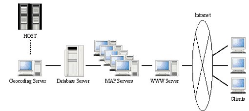
PASCO offers Business Navigation Service, which unites map contents and customer information that a company owns. The technology of this service is based on a system developed as an Intranet WebGIS SECOM MAP for business activities of SECOM Co., Ltd. SECOM MAP can be accessed from several thousand sets of Intranet terminals at SECOM offices. A client accesses a server by Web browser (Java applet). An application created by is used for the map server, and ArcSDE (Oracle8i) is used for the database server. The customer positions are plotted on the map using the Geocoding Program that PASCO developed. In addition, to update the background maps (about 30 GB), we use the transportable table space, which is a new function of Oracle8i.
In 1999 PASCO Corporation launched a new GIS business aimed at private enterprise and it was a first step towards opening up the private sector market. By combining information owned by companies, and substantial map contents owned by PASCO as in-house data, we started offering "Business Navigation Service". This service quickly finds out the information needed in order to "grasp a market and an extremely competitive situation and to connect them to a direct action plan", and also to support decision-making and powerfully enable speedy action. With this service, a package for Marketing, CRM, or FM can be chosen.
The "Marketing" package of this service is based on a system developed as Intranet WebGIS "SECOM MAP" for business activities of SECOM Co., Ltd. In this paper, we have introduced about the system of this SECOM Map.
In SECOM, a GIS that can be conveniently used on everyday business was highly needed. Area marketing, such as grasping of a contract situation, evaluation of the operating power for every area, the potential customer excavation, and rearrangement plan of a position were needed for the head office. Moreover, the functions for acquiring reference to customer information and the operating information on their business area on a map was needed for the local offices.
First, the stand-alone GIS application that filled these functions was developed as a prototype. This application was distributed to each office and only customer data was updated periodically every month. However, since there were very many offices, it was very difficult to maintain not only customer data but also background map data of any new area. In order to solve these problems, development of WebGIS system using the SECOM'S intranet network was proposed.
SECOM Map is used by several thousand sets of Windows clients in intranet environment of the company. Server configurations and the connection outline to the servers from a client are shown in the Figure 1.

HP HP-UX11.0 was chosen as hardware for database server. Oracle8i (R8.1.5) is used as RDBMS. Customer data, statistical data, and background data are stored in ArcSDE. Hardware and software composition are shown in the following table. OmniBackII of HP is adopted as backup software. OmniBackII performs in cooperation with RecoveryManager (RMAN) of Oracle, and is enabling daily automatic on-line backup by the scheduling function using DLT magazine that carries 20 slots.
| Model | HP 9000 L1000 |
| CPU | 440MHz 2CPUs |
| Memory | 1GB |
| Disk | Internal: 18GB External: 234GB (Fibre channel) |
| Other devices | DLT 8000 (20 slots), CD-ROM, DAT |
| OS | HP-UX 11.0 |
| RDBMS | Oracle8i R8.1.5 Enterprise EditionArcSDE 8.0.2 for Oracle8i |
| Other software | HP OmniBackII |
Five sets of PC servers were prepared for MAP server. System configuration is shown below. Map server application using MapObjects works in these machines. Since three applications per server are started, it is possible to process 15 requests from SECOM Map clients simultaneously.
| Model | HP NetServer LC2000r |
| CPU | PentiumIII 733MHz 2CPUs |
| Memory | 512MB |
| Disk | 27GB |
| Other devices | DAT, CD-ROM |
| OS | Windows NT 4.0 Server |
| Software | Map Server Application(MapObjects+VisualBasic) Oracle8i R8.1.5 Client component |
WEB server is a PC server with IIS4.0 (Microsoft Internet Information Server 4.0). Using load distribution technology of MO/IMS(MapObjects Internet Map Server), the request from a client is assigned to one of the 15 mapserver application processes.
| Model | HP NetServer LC2000r |
| CPU | PentiumIII 733MHz 4CPUs |
| Memory | 1024MB |
| Disk | 27GB |
| Other devices | DAT, CD-ROM |
| OS | Windows NT 4.0 Server |
| Software | Internet Information Server 4.0 MO/IMS Web server component |
This server is a batch-processing server which processes customer data transmitted from the HOST Server to point data with a address matching program. Using SDE C API, the program updates the data stored in the Database server daily. The details of this process will be explained later. Machine specification is almost the same as that of MAP server.
In this system, PC installed Internet Explorer is used as a client. A Client accesses a web server and downloads a JAVA applet customized for this system. SECOM Map user uses many services using this applet.
Using GUI created by Java, each client of SECOM Map performs map operation according to the purpose. When "station", "address", "office", "customer", etc. is specified, the destination map is searched and displayed. Those who use this system at an office refer to a customer's information displayed on the map, and use this information in order to respond to an inquiry from a customer. An information registration / correction function enable the registration of a landmark information and a visit history of prospective customers. Since various theme maps are prepared in this system beforehand, some clients use these maps for analyzation or operating activity. There are point layers of potential customers (a high taxpayer etc.), polygon layers that contain demographics totaled for every city or operating area, etc. A user can refer to new information of the polygon layer that stores information such as the number of contractors of several months and a customer's contract ratio, because GEOCODING server processes every day. If the areas currently displayed are the metropolitan area and a main city zone, an aerial photograph (1m resolution) can be displayed together with other layers.
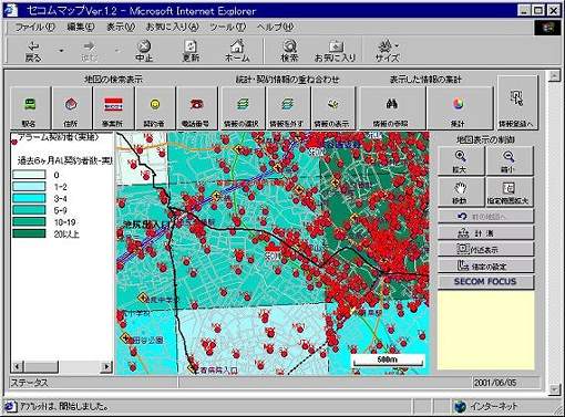
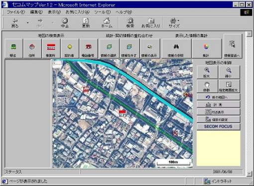
Our company has developed the general-purpose and highly efficient map server application for the use of as WebGIS with MapObjects and VisualBasic. The client component (Java Beans or ActiveX) for communicating with this map server application has also been developed together. These application and components are also applied to ASP services or other Internet/Intranet enterprises of our company. SECOM Map also used these map server application and Java Beans, and we created the client JavaApplet for filling the demanded functions.
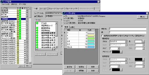
We built the system for changing the customer data updated by the host side every day into map data. We call this "daily processing."
Customer data is transmitted every day with a difference flag (addition, updating, or deletion). Additional or updating data is changed into point data using address-matching program that our company developed for use within Japan. The point data is added or updated at the database server with the batch-processing application that uses C API of ArcSDE. With a written mistake of the address or accuracy of the dictionary for an address match (that with which the address and coordinate values are matched), some customer data may fall to the same point. In this case, two or more customers will be seen as a single customer on a map screen. The customer position is spirally plotted so that two or more customers' position may be understood that it is the same point at a glance, because we needed to change a symbol for every customer.
In this system, system construction was planned so that it could be less stopping for 24 hours. It was also considered so that stop time might be shortened especially at the time of exchange of the huge background map data if possible. The total size of read-only data (background maps and oracle tables) stored in Database server is 30GB. We expected that 2-3 days will be required by the usual data loading method (import/load data and create index) while the system is working, and so the performance will fall remarkably during this operation. Although processing time will be shortened if the system is all stopped and changed into the optimum parameter for data loading, it will become impossible to provide service meantime.
Then, we tried the renewal of data using the transportable tablespace feature, which is the new function of Oracle8i. This feature enables a subset of an Oracle database to be moved into another Oracle database. Since the time of import or index re-creation becomes unnecessary by this, only restoring a data file from backup media (DLT) to a hard disk completes updating work. In the addition and renewal of SDE layer, it's important to be cautious of transmitting SDE tablespace containing layer information. Because of deletion of SDE tablespace, a system must be suspended only in the meantime (several minutes).
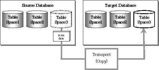
We replicated the database on another hardware and tried this new feature. Consequently, regardless of the size of data size, the system stop time for renewal of data can be completed now in several minutes. However the service may be stopped by way of precaution during restoration of data files and backing up of full database.
In this paper, the "SECOM Map" was introduced as an example of the Intranet GIS system for utilizing the data which a company owns. By making the intranet system, the customer data updated daily by the host server side was able to be reflected, the request from several thousand sets of clients could be processed, and performing update of application by functional improvement or renewal of data can be completed simply. We were able to make the WebGIS package "Business Navigation Service for Marketing" taking advantage of these experiences.
This system was also able to show that mass data could be updated in very short time using a feature of Oracle8i transportable tablespace. In the future we want to construct a system that is completely non-stopping for 24 hours.
I hereby thank Mr. Jun Abe, Mr. Zemin Zhang, Mr. K. K. Mishra and Mr. Shinji Tanaka for their helpful advice and encouragement to present myself at Esri User Conference.
Oracle8i Concepts, Administrator's Guide, Utilities