This paper presents the use of GIS for slope disaster prevention activities in a local government in Japan. Monitoring and prevention of steep slope failure is one of the critical issues for local governments. Many of them have started to develop disaster information systems using GIS to support slope management and disaster prevention activities.
This paper focuses on two examples of GIS use, identification of hazardous areas for slope failure and information management systems for those slopes. In some cases, 1:2,500 scale map data including digital orthophotos, DEMs, buildings, etc. were prepared and GIS-based slope identification criteria was proposed.
Monitoring and prevention of steep slope failure is one of the critical issues for local governments such as Wakayama prefecture. Wakayama is located in Kinki region and has area is 4725 km2. In order to manage the steep slopes, photo-interpretation using 1:2,500 maps was carried out for the whole area of Wakayama prefecture to identify the hazardous areas prior to field investigation. Although a manual to extract the hazardous slopes has been prepared, this method causes an inconsistency in the accuracy derived from the experience of the photo-interpreter. Therefore, a methodology to extract the hazardous areas for steep slopes using GIS was developed in order to quantify the process of extraction of hazardous area for steep slope. In addition, a GIS for steep slope management and to mange the sediment control has been built for the government of Wakayama prefecture.
This paper introduces the methodology to identify the hazardous areas of steep slopes using GIS and will compare this methodology with the results of field investigations to verify the accuracy of this methodology.
GIS layers for slope management were designed for this objective. Data from 1:2,500 scaled maps, including contour lines, and buildings were prepared as well as digital orthophotos. A DEM was derived from the contour lines and the attribute of the buildings such as, status of use, materials etc. were attached.
The GIS model to extract the hazardous areas for steep slopes is developed based on Ågsusceptive steep slope inventory guidelinesÅh, which are published by Ministry of Land, Infrastructure and Transport, Government of Japan. Figure-1 shows the model to extract the hazardous landslide area that is described in the guidelines. According to the model, hazardous slopes can be determined by several aspects, such as height of slopes, number of buildings inside the predicted affection area. Slopes more than 5m in height and more than the 30 degrees can be classified as a hazardous slope. The affected area can be determined by the direction of slope and distance from the foot slope. Areas within 50m from the foot slope and two times of height (2H) are determined as hazardous and the wedge of 30 degree from slope is also determined as hazardous area.
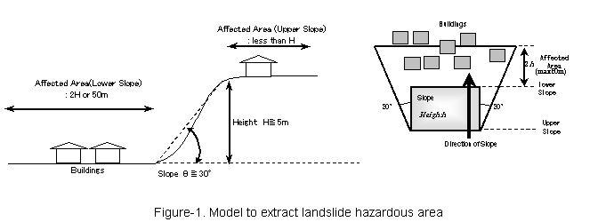
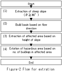
Figure-2 shows the workflow to determine the hazardous slopes using GIS. All processing was carried out in the GRID module of ArcInfo Version 7.2.1. To identify the slopes more than 30 degrees, slope data was derived from DEMs in degree units and the flow direction was calculated in order to delineate the watershed boundaries. Watersheds can be used as a calculation unit to determine the hazardous slopes. Direction of the slopes and height of slopes were calculated for each watershed to determine the affected area.
Finally, the buildings and affected areas were overlayed to extract the hazardous slopes based on the number of buildings within the affected areas.
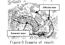
A field investigation was conducted using the results of GIS based hazardous area extractions in the year 2000. Table-1 shows the difference of number of hazardous area extractions in a 1/25,000 map sheet and Figure-3 shows the extraction results.
Table-1 Difference of Hazardous Areas
|
No. of Hazardous Slopes by GIS |
Overlap Area |
||
|
Steep Slope Rank-I |
Steep Slope Rank-II |
Total |
|
|
671 |
175 (26%) |
211 (31%) |
386 (58%) |
Based on the Table-1, 386 slopes, extracted by the GIS based methodology out of 671 (58%) were judged as hazardous steep slopes with Rank-I (more than five (5) buildings are located in the affected area) and Rank-II (1-4 buildings are located in the affected area) by field investigation. It indicates that extraction of hazardous steep slopes by GIS was obviously effective for a preliminary survey.
Monitoring and prevention of steep slope failure is one of critical issues for local governments and effectiveness and clarity are also required. The main objective of this paper was to illustrate how a GIS based methodology was used to identify the hazardous areas in Wakayama prefecture. According to the verification with field inventory, it was shown that GIS based methodology was quite effective to identify the hazardous areas and the results of the GIS methodology assisted the preliminary survey for field inventory work.
Now the Wakayma prefectural government is planning this information on these hazardous areas for steep slopes accessible through the use of web-GIS technology so that it can be shared and make a better contribution to disaster management throughout the prefecture.
Horiuchi Shigerou, Matsumoto Tsukasa, Kishioka Masatetsu, Ohashi Kazuya, Wakayama prefecture, and Reese W. Plews, for their support.
Susceptive Steep Slope Inventory Guidelines, Ministry of Land, Infrastructure and Transport, Government of Japan, 1999.