ABSTRACT
For several years LIDAR has promised revolutionary advances in precision altimetry and vegetation-cover penetration. Some of the first production class products are now in deployment. Using off-the-shelf hydrological methodology, this paper examines LIDAR data in a flood-prone corner of South Louisiana, a place normally resistant to analysis with traditional DEM data. Some natural research questions arise: Do otherwise unrecognized threat zones emerge? Are there vulnerable links in evacuation routes? Are there developed areas which require protective measures? How, in general, do LIDAR products compare with what we have used in the past? How does LIDAR data integrate with Census data? Does LIDAR present any unexpected problems or benefits to a planner or geographer?Light Dection And Ranging, LIDAR,has been well known in the remote sensing community since the beginning of the decade (Jensen, 2000). It forms part of a growing array of RS products, such as the multitemporal NALC (North Ameican Land Cover) and the very high resolution IKONOS platform, that has redefined our expectations of the key dimensions of spatial analysis: spectral resolution, spatial resolution, time, and terrain.
It needs to be added that these products are generally easy to use, or at least less hostile than the products of a decade ago. Consequently, these products are more accessible to scholars and experts from other disciplines further along the data chain, who now have new bases for visualization, quantification, and hypothesis testing in their own fields.
Even so, LIDAR, like many innovations in scientific instrumentation, has been slow to deploy (say compared to overnight revolutions like the web). To some extent this is true of other innovations such as NALC (whose popularity inexplicably lagged behind its obvious ingenuity, transparency of concept, and utility) or IKONOS, which still has daunting startup costs in academia. In the case of LIDAR, the barrier to entry is high compared to most RS data because it is gathered from aircraft with very specialized equipment. But LIDAR has now gained widespread acceptance as a mainstream RS technique that produces elevation data hard to surpass. LIDAR has commonly been introduced to propspective consumers in terms of two major advantages: (1) its flexibility in high-relief areas and (2) its ability to penetrate dense terrain cover. In effect, LIDAR's promise (Heidemann, Roberts, Renslow, and Gross (2000) has largely appeared with data drawn from the forests of Cascadia or the breathtaking landforms of Glen Canyon. This use of LIDAR certainly validated its capabilities in areas that have an immediate use for its capabilities. As a result large organizations and states are making large data repositories available.
(See this link for Louisiana or here
Managing forests and deserts is, however, quite distinguisible from the problem taken up here -- monitoring urban sprawl on the verge of wetlands. This latter problem suffers from two difficulties.
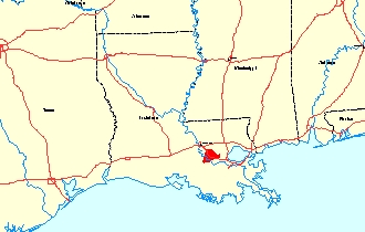
One, the operational definition of sprawl, is theoretical (at best) and political (at worst.) To the extent that urban development threatens sensitive habitats or valuable agricultural land, it is a readily cognizable problem that deserves the term sprawl. On the other hand sprawl is often used as a broad brush to paint low-residential density seeking classes of people politicians don't like, and whom they would like to tax (Beatly, 2000, Calthorpe 2001, Gillahm 2002). The conceptual difficulty with places like South Louisiana lies in the fact that older cities, like New Orleans, are dangerously exposed to the elements, and can be protected only by massive engineering feats consisting of levees, canals, and pumping stations. The suburbs, for their part, get off the continental shelf, and move into more hospitable pleistoscene zones, but often by encroaching on wetlands and watersheds. This is, to a large extent, completely unavoidable without leaving the entire region. As the following LANDSAT (ETM+ scene id LE702239000131150, acquired 7 November, 2001) image shows, (or any NALC triplicate would), the area is a tangle of forest, wetland, and waterways.
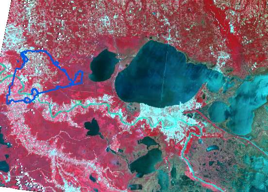
Southeast Louisiana From Space
These areas are, of course, protected. However, no protection regime means the same thing as leaving things in their natural state. Population in this area of the nation clusters along the axis of the Missisippi River, a feature that spins the geological and geomorphological clock very rapidly. Urbanization, oil and mineral extraction, one of the world's largest petrochemical complexes, flood control structures, agricultural practices, and navigation safety measures have all combined to complicate any notion of a baseline "state of nature" for the lower Mississippi. The imprint brought about by the decision of human beings, more than four centuries ago, to make this area their habitat too, is large and complex. Even subtle, local changes, have unintended -- and often unmeasured -- consequences. The area outlined in blue is Louisiana's Ascension Parish, now a target for suburbanization from Baton Rouge, and the focus of the area we will examine with imagery.
Many of the consequences of changes in human habitat come from the apparent lack of relief in the area. There is more relief than meets the naked eye, and at any one time residents soon become familiar with even slight changes in relief or runoff coefficients. Tropical downpours, common in an area with nearly 60" (25cm) of annual rainfall, will quickly betray changes in hydrology induced by development and construction.
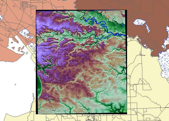
The image above shows a colorized lidar image superimposed on an area consisting mainly of a portion of Ascension Parish, part of the Baton Rouge agglomeration. It is, in some senses, a stereotypical sprawl target. Ascension used to be an agricultural area (a lot of cane sugar) and features a major petrochemical zone fronting on the Mississippi River, often cited as an example of environmental racism. The choice of Ascension Parish does not stem from any of the features that make it unique. Rather, the Prairieville, LA USGS Quad, in Ascension Parish, was simply the first data set of many in the flattest and wettest part of Louisiana. There is no place I can think of, off-hand, that contrasts more with the LIDAR examples I have seen so far.
In examining the data behind this image there are several aspects of the data I will try to illustrate:
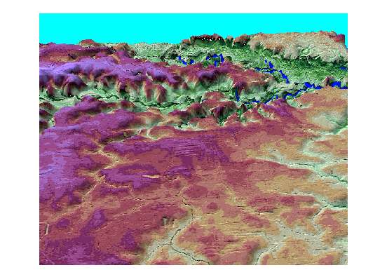
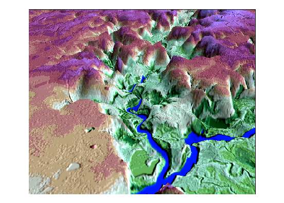
These two views come from ERDAS' Image Drape facility, but Esri's 3D Analyst can generate similar views. The effects seen here, to some extent burlesque LIDAR views of the Colorado upstream from the Grand Canyon, but that is not my intent. Rather, in most GIS and RS applications that have audiences outside of a scientific community, arguments are made with visualizations rather than with analytical cartography, which, in turn, usually trumps statistical presentations.
This pair of images puts artificial shading atop a vertically exaggerated DEM derived from a mosaic of four LIDAR quarter quads. It is possible to put other overlays atop the DEM. Likely candidates are SPOT true-color images, color infrared (CIR), IKONOS (when someone acquires this area), or thematic maps from NALC or MRLC. Data coming from those sources add information to the DEM from independent sources and, in effect, validate what we are looking at.
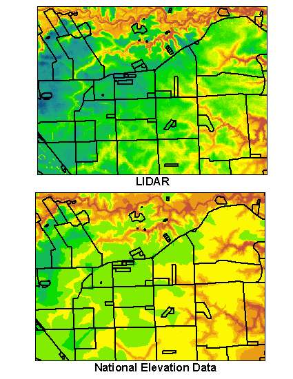
We can approach some of the spatial characteristics of this dataset by resort to looking at it in the context of a well-known dataset drawn from vector GIS. Here I have superimposed Digital Line Graph (DLG) road vectors atop LIDAR and a companion National Elevation Dataset DEM downloaded from the USGS http://edcnts12.cr.usgs.gov/ned/ . There is, as one would expect, more vertical detail in the LIDAR set. This image pair does not fully exploit the differences, but shows why the LIDAR image is of great interest to data consumers studying terrain like the Prairieville Quad. The surface is less generalized, and shows various knolls,gullies, and ridges not apparent in the NED image. At larger scales street patterns begin to emerge independently of the DLG overlay.This raises the question of to what extent LIDAR data of this set's resolution will support feature extraction operations.
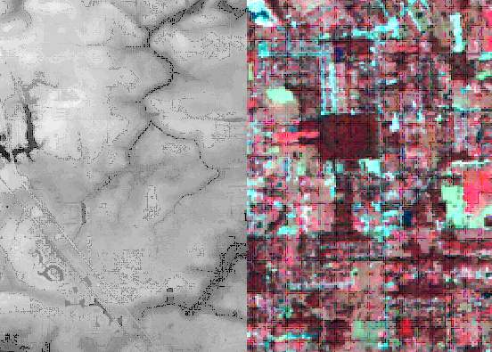
An initial step to understanding how LIDAR can be further exploited beyond its DEM capabilities is to treat it as another band. In this case I will add it to a contemporaneous ETM+ six-band (1,2,3,4,5,7) stack. It is easy to see from the figure that there are gross differences between the 30 meter LANDSAT type pixels and the 5 meter LIDAR elements. In this illustration we lose a lot of detail because of jpeg compression. But the general idea of adding another layer to a sandwich should be apparent.
One conventional way to evaluate the results of this data accretion strategy is to model the set with principal component analysis. PCA manages to simplify the data, and also identify independent segments, latent bands, in the layer-stack structure. The image below, in which the LIDAR layer became band 1,a brightness factor band 2, and a greeness factor band 3,
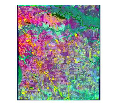
In general, tables of eigenvalues coming out of multispectral imagery doe not have an intuitively obvious interpretation. But this vector suggestes four major dimensions of information -- the usual brigtness, greeness, wetness triad found in LANDSAT and its look-alikes -- and a new dimension, relief, revealed by the LIDAR band.
The warmer colors, higher areas, are readily apparent and provide a generalized scheme of more suitable places for development, at least in terms of flood evasion. It is the case, however, that looking at this kind of image, which is novel to most of us, requires some getting used to, and this particular combination is only one of many that might prove useful. It is also arguable that other data programs, such as SPOT or IKONOS may be a better match for this kind of LIDAR's fairly high spatial resolution.
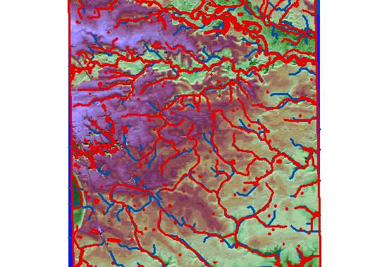
The two obvious emergency related uses of DEMs are for fire (it climbs) and for water (it plumbs). The study area we have looked at falls, most frequently, into the latter category. The illustration below is the outcome of an experiment in comparative hydromorphology. The point logic of the experiment is transparent. The red waterways are taken from the hydrology layer of the USGS DLG series. These are a form of control. The bluish lines represent empirically derived stream networks. They are the outcome of a simple series of surface hydrology routines in GRID. Probably the biggest weakness of the experiment was resort to creating a smoothed (filled) DEM from the original LIDAR surface. It seems likely that one of the biggest problems residents of the area would have be local sinks. They interfere with modeling steam networks, but they meddle even more with the normal flow of traffic and access to schools, hospitals, and other public facilities. But there is an advantage, for purposes of argument, to treating LIDAR as though it were just another DEM subject to nagging errors in surface representation. In this instance there are appreciable differences between the two networks. In general, LIDAR (blue paths) seems to be able to link a number of isolated sinks that show up in the DLG representation. These links are, in a sense, rebuttable hypotheses about the flow of water under conditions verging on flood stages. This is the kind of finding that should normally attract the attention of both planners and engineers.
LIDAR will be novel for a few years as more and more products reach scientists, engineers, and planners. Its applications seem wider than its pioneers envisaged. Its capabilities as a topographical and and hydrological tool appear to have lived up to, or even exceeded, expectations. The spatial properties of LIDAR products meet or exceed those of many products that LIDAR can complement as part of a multiresolution strategy. To some extent LIDAR may be a DEM+, in that there is room for adding it as a data layer to other data sets, such as IKONOS. Obviously, LIDAR can serve as a surface to support image draping or volumetric studies. Less obvious is how it will work as a layer to enhance classification of landcover. In hydrology LIDAR may contribute to the updating of our notions of hydrologic units. For many of us, hydrology is a black art because it has to deal with four dimensions (Maidment and Djokic, 2000). In some portions of the nation this presents genuine difficulties because the z-dimension is all but invisible to water -- which invariably finds it, but often before local residents and authorities had a hint of changes in relief and runoff. So, in at least four areas: topography, spatial analysis, land use / land cover analysis, and hydrology, LIDAR products have worked their way into mainstream GIS and RS circles. As is the case with other data products, it will be diverted to unanticipated applications. The temptation to harness LIDAR imagery to novel applications comes in part from its spatial accuracy and its ease of integration with other data formats, both vector and raster.
Beatly, Tim. Green Urbanism. 2000. Washington: Island Press.
Calthorpe, Peter and William Fulton. 2001. The Regional City. Washington: Island Press.
Maidment, David and Dean Djokic. 2000. Redlands, CA. Esri Press.
Oliver Gillham, 2002. The Limitless City. Washington: Island Press.
Heidemann Karl, Barry Roberts, Mike Renslow, and Spencer Gross (2000). "Introduction to LIDAR Data" Pre-Conference Seminar. Esri Users' Conference 2000
Jensen, John R. 2000. Remote Sensing of the Environment: An Earth Resource Perspective. Upper Saddle River, N.J.: Prentice Hall.
John K. Wildgen is Freeport McMoRan Professor
of Urban and Regional Planning
College of Urban and Public Affairs
University of New Orleans
Lakefront 2000
New Orleans, Louisiana 70148
Tel. 504.280.6521
Fax. 504.280.6272
email jwildgen@uno.edu