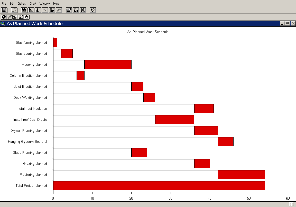
Figure 1. As-planned schedule bar chart.
Wei Sun, Ph.D.
M. Jo. Hasell, Ph.D.
University of Florida
Abstract
This paper discusses a framework for an integrated information management
system for architectural design, engineering and construction, based on
GIS technology and a GIS based tools. The system enables architectural
project participants to access, navigate and manipulate information typically
used in architectural projects to support the decision making process during
various project phases in an integrated environment.
The complexity and diversity of the vast amount of information in building design, engineering and construction projects requires a coordinated and consistent system that enhances full integration of information. This paper discusses the potential of using GIS (Geographic Information System) in building project information management and analysis through the testing of a prototype GIS-based spatial information system.
Using GIS in Building Project Information Management
GIS technology has potential for building a project information management application that can provide pragmatic solutions to the problems of integrity and consistency of the information. In a stricter sense, a GIS is a computer system capable of assembling, storing, manipulating, and displaying spatially referenced information, i.e. data identified according to their locations and dimension. The optimistic view of geo-relational modeling is that it has the potential to be very useful for building design, engineering and construction project information management because its operation is predominately based on physical assets covering a certain spatial area.
GIS applications are becoming common in diverse areas related to building projects such as facilities location and planning, site selection and preparation, land management, road planning, management and design, environmental monitoring and analysis, residential and commercial site surveying, public works surveys and engineering, municipal and utility surveys, infrastructure evaluation, soils modeling, and etc. For the building design, engineering and construction industries, however, the technology of GIS does not have a wide range of applications.
For most building projects, CAD applications are used and so are database applications. Since CAD is designed for facility design, it provides a good package of graphic capability but lacks data management functions. Also since the information in the database does not include graphic representations, it is hard to browse objects. To resolve the practical limitation of both CAD and database systems, many research projects on integrated information system have developed integrated CAD-database programs that links CAD graphic elements to database records. These types of applications indeed integrate the graphics with the data to some degree, but they are built with a special utility to link graphic and non-graphic data. GIS applications provide similar graphical interfaces just as CAD, but in addition extend the capability of associating non-graphic data with graphics, and incorporating the database applications too. This approach is superior to either a CAD or a database application. This study introduced a natural progression that increases bothsemantic information (i.e., CAD entities modeled as specific building components rather than generic shapes) and non-geometric information in the currently available CAD models. Thus this study moved one step closer to using a GIS-based information integration system.
Design of a prototype GIS-based spatial information system
The philosophy behind a GIS-based spatial information system development
was to construct a model in terms of a GIS system that matched a building
project process as closely as possible. The design of a model for
the provision and interchange of information within a project implied that
the real-life project can be modeled in a way that allows functionality
in a system. The information model should have general usefulness for performing
different functions, should capture significant levels of detail, should
include a wide breath of project information, and have flexibility in what
information can be represented and how the information can be used. Therefore,
for the information framework to make significant progress it is essential
to integrate the potential of the GIS model and research results for building
project modeling. As a result, the information model is hybrid in a sense
that the information framework aims to address the modeling issues by building
on the basic model of GIS, in accordance with the findings of the building
project modeling. The geo-relational approach is superimposed on project
modeling methodology to achieve a comprehensive information framework that
supports coordinated and effective communication within the information
integration process.
The proposed project model in this study adopted most of the fundamental
concepts required to describe a building project. The main approaches are
1) identification of entities, keys, and attributes from data sources associated
with each system component, 2) establishment of entity relationships, and
3) justification of the functionality of these relationships, based on
semantic description of the project management schema. The resulting information
model has a set of specialized types of engineering information, such as
analysis models and algorithms, constraints, time-dependent processes,
and other types of data that are somewhat unique to the engineering domain.
Semantically, the object-centered technique can be exploited for project
data definition and integration in the modeling. By predefining the object,
a description of the project model can be attached to the feature.
System Testing
An application protocol was developed building upon existing GIS software to test the GIS-based integration strategy proposed. A prototype system was built on a GIS system to test the effectiveness of the proposed research approach. The selected GIS system is the Environmental System Research Institute (Esri) software ArcView Geographic Information System. ArcView was selected from among the other possible GIS systems because it has a powerful development language called Avenue. The project database was implemented as tables in combination with spatial themes. The project model is implemented in Avenue scripts. The integrated system facility was developed based on ArcView graphic user interface consisting of individual but inter-communicating units supporting various functions and activities of the integrated system. The prototype was considered a a development model of the system only for testing purposes. After installation of the coding into ArcView, the prototype system was tested for reliability and quality.
The testing process began with the collection of all the basic information or data that were relevant to a certain project. The feature objects were built with feature object definition tools. User entry through the interface was input into the database and the project database was populated. During the information initiation stage, the data for one specific project aspect was introduced, and included the physical and functional representations of the construction product and/or activities for this phase. These were then entered into the integrated system to provide the basis for a digital representation of the real world. Data consisted of architectural design plans, the actual construction knowledge data, photographs, drawings and notes from the job site. The data included actual field data, generated data, or historical data. The data format can be a text description, a numerical value, a date/time value, or a counter value. During the information transaction stage, data were transformed to an open project model via an information transformation process. Within each transaction process, a model partition was decomposed to a specific degree of granularity, and then synthesized with other model partitions. During an information exploration stage, any piece of information about the project was selected by constraint propagation and satisfaction. Then the system was tested for functions directly related to the building project that professionals use, including project planning, preliminary cost estimation, project site condition analysis, and change order analysis.
1. Analysis of project planning: Given the technological dependencies between activity objects, their location, and the hierarchy of planning premises, it was possible to derive algorithmically their network, allocation of resources, and schedule. Tasks were allocated by the system from the project feature object database to each work type. The related records in the product feature object table, activity feature object table and method feature object table were used to generate work items on the basis of work assigned for the installation of products using pre-specified methods. Work sequences were determined by the system based on the precedence relationship of the various activities for all the work items. With an estimated duration value, timing could be calculated for each work item record in terms of start time and end time as a plan. According to the plan, a schedule bar chart was created as illustrated in Figure 1.
Figure 1. As-planned schedule bar chart.
2. Preliminary cost analysis: Once feature objects were created, a cost view of the object read the feature object database and created instances of work items in the database and populated the attributes of quantities and rates. Quantities were derived from the product components whereas rates were established from the work items and resources. The preliminary cost analysis was created by the system to convert a feature object database describing the test project as a list of specific cost components, with which unit prices, units of measure and quantities can be associated to form a cost estimate. While each cost component record has a unit cost attribute and quantity attributes, the cost for each cost component was calculated. The cost of the cost item was calculated by using the equation: cost item cost = (Quantity)*(Unit-Cost). This process was repeated for all the cost components. The resulted cost estimate was reported in the cost estimate table, as illustrated in Figure 2.
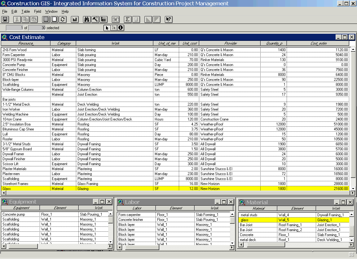
Figure 2. Preliminary cost estimate result
3. Project site condition analysis: The re-structuring of project products and processes was a prerequisite for project control. These information requirements were categorized into general project database and support knowledge. The general project monitoring included exploration of the following information: 1) the products, 2) the processes or actions, 3) the resources, and 4) the on going site condition records, the pictures of site conditions and the necessary regulations and specifications. Also, a nice feature for project monitoring was to be able to check the history of project by looking back at the conditions on site. The project site condition was constructed and the site items were built with the information from the project feature object database. The user explored the site conditions and project progress by using identification tools to click on each individual site item on a map display to obtain detailed and updated information, as illustrated in Figure 3.
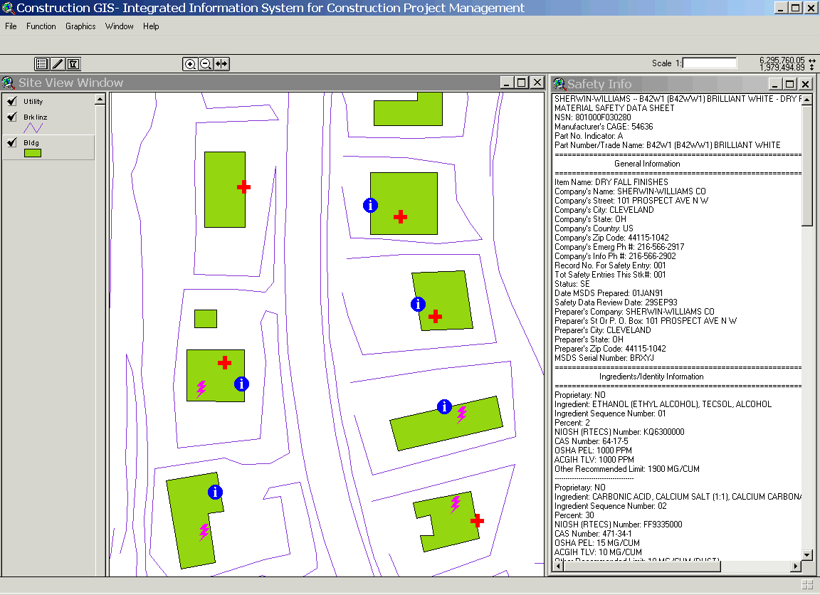
Figure 3. Site condition analysis result
4. Analysis of change order: When a specific item needed to be changed, a user could manipulate the change directly through the map whether the change was spatial or a database non-spatial attributes entry. Once changes were inputed, a change sensitive analysis was done to recognize any potential influences. As a feature object supported the creation of "intelligent" project databases, where project data were stored as objects combined with rules that responded to events and reacted to a context, the change event on individual data were propagated and notified to related data. For example, a "wall" object could inform other objects that its dimensions changed or simply change its dimension if alerted to a change in the connected floor. The consistency and constraint were checked automatically by firing the updated event on specific project items. If there was a conflict because of the change, there a flag indicated that the transaction could not proceed. If no conflict was found, conversion on related product feature object was shown on the display and the difference was indicated, as shown in Figure 4. After a user confirmed the change editing, then the change on the product item was committed. If a user discarded a change, then the change on the project item could be recended.
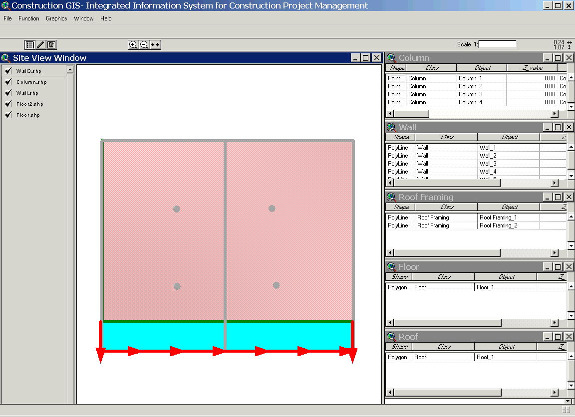
Figure 4. Example of change analysis result
Conclusion
The resulting GIS-based integrated information system is a mechanical
system for information analysis and manipulation. Basic functions of the
GIS-based integrate system are the storage, retrieval, analysis and display
of spatial and non-spatial building project data. The prototype spatial
information system demonstrated the adequate functions of GIS-based spatial
information systems for getting relevant product data technology in place
to effectively supports building project information integration. Methods
used in this prototype also suggested improving the efficiency of the linkage
between GIS and models to include implementing various database management
strategies and interfaces within a GIS environment.
The prototype system strongly promotes the concept of automated acquisition
and storage of data to support project management. Instant spatial data
capture provides fast, accurate visual information about the progress on
the site. Integration of the spatial database with project management functions
provides a powerful and effective management control system. As demonstrated
in the developed prototype system, integrated project data can be visualized
by instantly color-coding the spatial display based on non-spatial attributes
such as status. This makes the project data available in a very powerful
and understandable way. Through GIS visualization, multimedia capabilities
and easy access to the integrated project data, this integrated system
can be used very effectively for manipulation and comprehension of integrated,
dynamic project information. Preliminary results indicate that considerable
potential exists for use of this system for building project information
management.