Risk-Era: The Swedish Rescue Service's Tool for
Community Risk Management
By Janet Edwards, GIS specialist and project managerKarlstad, Sweden
Abstract
Risk-Era is a MapObjects based tool used to complete a community risk inventory.Development is ongoing and the current phase involves writing a technical
specification for version 2.0. The new version will allow the user to analyse risks by
identifying a risk source and then describing a common scenario and the worst-case
scenario. The project began in 1999 upon the request of a few community fire
departments. Several representatives from primarily fire departments but also
planners, technical experts and environmental specialists were asked by the Agency
to participate in an advisory group. The first year the group discussed in depth what
type of data would be used in the program and how the program would look.
Throughout 2000 risk managers and computer programmers from Lund's Program
Architects (LPA) worked together to develop the first version of Risk-Era. In 2001 and
2002 several new functions were added by programmers from SysTeamGIS.
Users can open their own community maps in .dxf or .shp format. Scanned and
geographically referenced bitmap or jpeg maps can be used with the system. The
program allows map layers to be selected and saved in a project file with a format
unique to Risk-Era. Symbols have been designed which correspond to all the objects
classes as well as all the accident types. Users can mark the locations of risk sites
directly on the digital map or they can enter or import X- and Y- co-ordinates for their
locations. GIS functions were carefully selected so that the system would be easy to
use and not require any special training in GIS. Digital photographs, video clips, or
other documents can be linked to registered objects. Because the data is stored in
MS SQL-Server 7.0, import and export of data is efficient.
Risk-Era's purpose
The aim of Risk-Era* is to provide a low cost, user-friendly geographic computer
system for community risk management. Risk-Era is designed for location and
analysis of accident risks. The first version of Risk-Era allows users to complete a
comprehensive risk inventory. Risk-Era was programmed using Delphi 5.0
Enterprise and Esris MapObject 2.0. The program operates with the database
manager MS SQL-Server 7.0. (*"Riskera" is the application name used in Sweden.)
This GIS application is part of a larger system that is called RIB or the Swedish
Rescue Services Information Bank. Currently RIB is in Swedish, however an English
version will soon be complete. Risk-Era's version 1.2 was developed during
fall 2000 and spring 2002. An English translation of the program will be ready at the
end of June 2002.
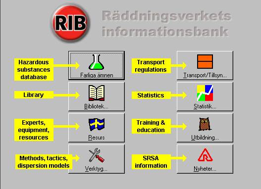
The Swedish Rescue Services Digital Information Bank
How a community uses Risk-Era
Each community has the responsibility for identifying their risks. They are registered
in the program with a specific geographic location. Each risk object is then classified.
(See the attached list.) A risk source can be registered for each risk object and its
location shown on the map. A risk object's attribute data includes address, inspection
routines, potential accident types, measures for accident prevention, measures that
limit damage, rescue routes, technical installations and more.
Community experts register objects that require special protection in case an
accident occurs in the vicinity. These include housing areas, health care centres,
public arenas, schools, natural and cultural sites, and community infrastructure. The
reason for protection is also registered in the database. If available, relevant data
from other data systems can be imported into Risk-Era's database.
Accident information is an important factor in determining the risk picture for any
community. This information contributes to the assessment of accident probability
and consequences. All fire and rescue departments register incidents in a computer
system. The data on accidents is then sent to the Swedish Statistics Bureau.
The same data can be imported into Risk-Era. All accidents with a geographic
location can be seen on the map.
Community users decide what types of maps will be used in the system. They can
select thematic map layers and combine them as they wish. In this picture map
layers that represent lakes, roads, property boundaries, buildings and trails can be
seen.
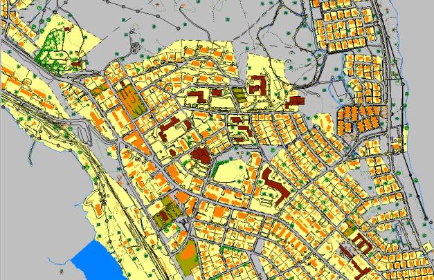
Map themes for Vilhelmina city. Geodata from the community of Vilhelmina.
Registering risk objects
Users can get a closer view of the city by zooming in to city streets and even
buildings. When a risk object has been registered in the database, the user assigns
the exact coordinates for the object. Risk objects are grouped in classes and each
class has its own symbol. The system places a symbol on the map after the object is
classified. Objects requiring special protection also have unique symbols. Risk-Era
manages data about sites where risk sources are found.
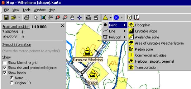
Symbols representing risk object classes.
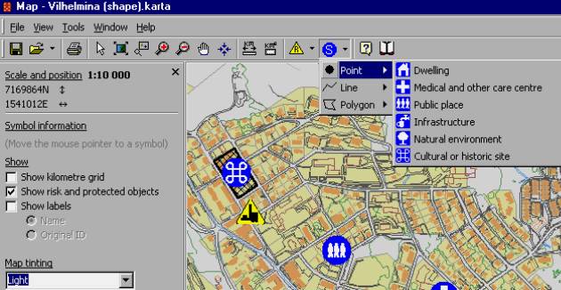
Symbols representing threatened objects
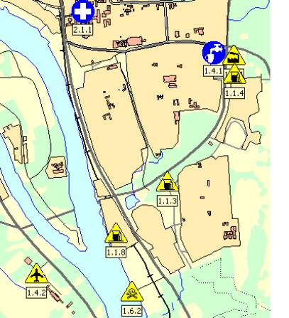
Selected risk sites (yellow symbols) and sites requiring special protection (blue symbols) are
shown on a community map. Geodata from the Swedish Land Survey Office.
The user can mark the location of any risk source connected to a risk object. (See the
attached list.) These are shown as red triangles on the map.

Red triangles show the location of risk sources at a risk site. This example is
fictitious.
In addition, GIS allows risk managers to study accident statistics. In version 1.2
specific symbols are used. Even environmental accidents such as a landslide or
slope failure will be designated on community maps. The alarm number, the date, the
number injured or killed and damage to property or environment are some of the
attribute data which is associated with the accident site.
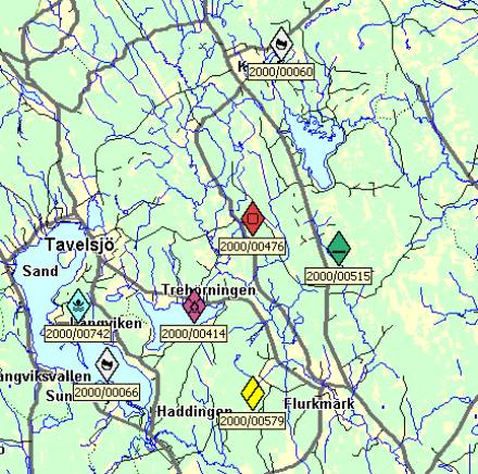
Selected accident sites with the corresponding alarm number.
Risk maps
Several communities have risk maps for flooding and slope failure. They can be
easily opened in Risk-Era. In this example the various risk zones for slope failure
have been mapped. In Risk-Era a risk manager can quickly see if there are any
A risk map showing slope stability. Geodata developed by the Swedish Institute for
Geological Research.
dwellings or other objects of concern that are situated in these risk zones.
The Swedish Rescue Services Agency has financed a project that resulted in a map
showing environmental sensitivity in the community of Ume�. Such a map can be
opened in Risk-Era as a thematic map layer. The legend shows two things. The first
is how long it takes before water or soils are damaged from a chemical spill. The
second legend defines levels of desired environmental protection. They are the
following: "very high level of protection desired", "high level of protection desired",
and "worth protecting".
Environmental sensitivity map developed by the National Defence Research Institute,
FOA-Risk, in Ume�.
Modelling and Application Development
The Swedish Rescue Services Agency intends to continue the development of Risk-
Era. During the fall of 2001 The Agency, in co-operation with the Swiss Federal
Office of Protection and consultants from Ernst Basler and Partners, begin modelling
the risk analysis module. In the first round only a few selected risk types will be
modelled. It is important that Sweden's risk specialists from fire and rescue personnel
are active in the development of Risk-Era. Therefore, an expert group comprised of
Swedish risk analysts was established in March 2002. These specialists work with
complicated risk analysis questions many of which involve safety at industrial sites.
At the same time they are able to recommend a general risk analysis method that is
uncomplicated and, therefore, can be used by all fire departments.
A GIS specialist from a computer company called Triona was also contracted to work
with the project leader during the brainstorming meetings. This GIS specialist directs
the writing of the technical specification for version 2.0. Upon completion of the
document, the Swedish Rescue Services Agency will request bids from any
interested computer application development company in the country. The bids will
be compared based on the technical solutions suggested, the quality anticipated, the
costs, and the suggested time plan. Once a computer company is selected, a
developing group will assure that all requirements for the program are met. Version
2.0 will go through the same rigorous testing process that is implemented for all
computer programs designed and financed by the Swedish Rescue Services Agency.
Functions for Analysing Risks
In version 2.0 the user will be able to analyse some of the risks within the
database.The following methodology will be implemented. Select a risk object with
one or more identified risk sources. Select an accident type for one of the risk
sources. Define a typical scenario based on this risk source. Define the worst-case
scenario.
There will be help functions that recommend a specific impact distance for the risk
scenarios. This distance will be shown on the digital map as a circle around the risk
object. A GIS function will be used to calculate the number of objects of concern
/threatened objects which are found within the impact zone. These objects of concern
will be listed by name and type.
Once a value for probability and another for consequence have been assessed, a
value for the total risk can be assigned. Finally, the risk level will be shown in a risk
matrix. Probability will be assessed using a scale from 1-5. The same interval is used
to assess consequences to life, the environment, and property. Search functions will
be supplied so that objects of interest can be analysed and their risk values
compared

The risk matrix shows the number of risks for each of the risk levels in the diagram.
After completing such an assessment it becomes easier for the community
specialists to prioritise accident prevention work. In Risk-Era communities can
register mitigating measures that are being taken or that should be taken to prevent
an accident suggested by the scenario. Such measures might include creating buffer
zones around areas to be protected. Communities can make decisions about limiting
development in risk filled areas. It could mean the relocation of transporting routes
for vehicles carrying dangerous goods. For industrial sites it could require a technical
improvement. Modification till slopes may be necessary if slope failure is eminent. If
flooding is a risk, then special training can be implemented for rescue crews.
Planners can also take this risk zone into consideration when making decisions about
property development.
Methodology Used in Designing Risk-Era.
In order to design Risk-Era, the Swedish Rescue Services Agencies implemented an
assortment of methods and tools. The computer application is based on the Swedish
Risk Management Handbook written over 10 years ago. It has since been translated
into English and published by the United Nations Environmental Program as a
technical report.
In addition several research reports about risk analysis have been reviewed. Other
computer programs have been examined such as CAMEO from the U.S.A., PHAST
from Great Britain and a few Swedish systems. GIS features used in other GIS
programs have been studied, primarily ArcView. In addition several groups have
been developed both inside the agency and outside. One of the most active groups
was an external group comprised of potential users. This was a mixed group of fire
specialists, city planners, technicians, and cartographers.
The group assisted in defining the goals for the use of GIS in version 1. These goals
have all been achieved by using Esris MapObjects GIS components.
Use several data types. Update or reorganise maps layers. Calculate distances and
areas. Assign the location of objects (X and Y co-ordinates). Digitise points, lines,
and areas on the screen. Import accident statistics with their locations.
Advantages of a GIS system for Risk Management
There are several advantages of using a GIS system for risk management. Many
data types can be collected and accessed. Maps can be updated or reorganized.
Objects can be located by using a query. Environmental data can be more easily
understood.
Difficulties Encountered
Here are some of the problems that we have encountered. The Swedish Rescue
Services Agency's clients are not accustomed to working with a database manager.
Installation is considered difficult. Import and export of data from other SQL
compatible bases occurs within MS SQL Server 7.0. Working in risk groups and with
technical questions requires time.
Janet Edwards is a GIS specialist and project manager- She is currently works for the Swedish Rescue Service Agency's
Information Bank. She has a bachelor's degree in geography from the University of California at Los Angeles and a
master's from California State University at Northridge. Janet began her work with GIS in 1985 starting with a course at the
Earth Resources Observation Station in South Dakota. She has also taken courses at the Swedish Institute for Geographic
Information Technology (SIGIT) and taught GIS at Karlstad University. Janet has worked for the Swedish Rescue Services
Agency since 1995.