LRS AND ENTERPRISE
GIS: A NEW TECHNOLOGY FOR
ROAD MANAGEMENT IN THE PHILIPPINES
Engr. Luz V. Lagunzad, MEngSci
Department of Public Works and Highways
Mr. Kevin McPherson
RIMSS Consultant
Engr. Gregorio P. Macaraig
RIMSS Consultant
ABSTRACT:
This paper discusses the enterprise Geographic Information System (GIS) being implemented in the Department of Public Works and Highways (DPWH) in the Philippines, and the role of GIS in the management of 28,000 kilometers of national roads and 7,000 bridges. It describes how GPS, GIS and the traditional database applications help manage the highway network through a common Locational Referencing System (LRS). The LRS and GIS help integrate all data on road and bridge inventory and condition. This information is then made available to planning, construction and maintenance processes in DPWH through GIS-enabled client applications. Internet-based mapping services will be made available to external stakeholders in the future.
Until recently, methods of locational referencing used by the DPWH were not suitable for comprehensive computerization of highway information. Many discrepancies were noted as to the exact position of the same feature as recorded by the different offices in the DPWH. This is because independent survey activities had been carried out by different organizational units within the DPWH with little attempt at coordination. This led to extensive collection and duplication of the same data for different purposes. To solve this problem, the Locational Referencing System (LRS) was used as the primary method to relate various types of road data.
Before the actual LRS centerline survey started, a series of workshops was conducted by the DPWH Central Office/Road Information and Management Support System (RIMSS) project for the regional/district level engineers on how to properly identify “nodes” at road intersections, administrative boundaries and “sections” which is the length of the road measured along the centerline between nodes.
The DPWH under the RIMSS project conducted a nationwide Locational Referencing System centerline survey for the 28,000 km. along national road network from December 1999 to June 2000. It used a comprehensive Global Positioning System (GPS) and video for collection of the data. The centerline survey was undertaken to establish an accurate location for the identified nodes and sections. The data collected was used to establish the exact length of the national road network. These data serve as the backbone for development of DPWH’s GIS and related applications.
DPWH has begun the establishment of an enterprise-wide GIS with the completion of LRS. It will serve as the backbone of the data for this GIS. It will enable implementation of embedded GIS, where the GIS and traditional databases combine to produce truly integrated applications. The same spatial representation of the road network will be used by all applications and will be used to manage various data on roads and bridge infrastructure, including condition, inventory, traffic, right-of-way and locations.
The Locational Referencing System is defined as anything associated with the road network through the use of “nodes” and “sections”. Nodes are defined as points in the road network. Typically these are intersections or administrative boundaries. Sections represent the road’s centerline between two nodes. A section’s limits and location are defined by the nodes that represent the end of the sections.
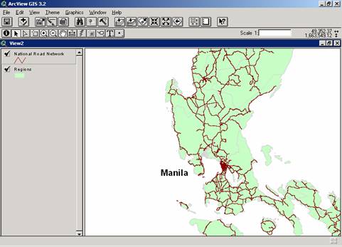
The primary purpose of the Locational Referencing System (LRS) is to accurately define and identify the National Road Network of the Philippines (see Figure 1). This was accomplished by establishing a standard link and node system that is utilized to store in a computer system all linear data related to road centerlines. The linear data to be stored include inventory of roadway features and roadway characteristics.
Figure 1 Sample of Philippine National Road Network
It had been the practice in various offices within DPWH to maintain separate data related to the National Road Network. This presents a problem in that the data stored by each office do not match. Therefore, if the question, “How long is the national road network?” is asked the answer will depend entirely on which office the question is addressed to. That is, the Planning Service and the Bureau of Maintenance will give two different answers. Without a common definition and understanding of the actual network, decisions made based on this information cannot be reliable. The DPWH has long recognized that accurate and reliable information on the national road network is essential in its efforts to improve and strengthen is business processes and decision making.
A GPS centerline survey data was conducted to address the spatial data referencing needs for DPWH. This was used as a foundation for referencing all data collected and for displaying road data in the GIS format. This enhanced the Department’s ability to display data in an easily understood format and facilitate the interpretation of these data. The GPS centerline survey data supports and strengthen planning and decision support purposes.
The survey also established the position of Locational Referencing Points. These points are generally the existing kilometer posts along the road. The survey also collected video data of the road network and roughness data of the paved roads.
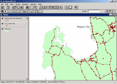
Figure 2 Sample of Nodes on Philippine National Road Network
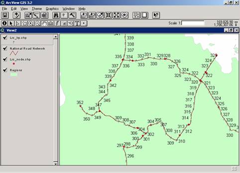
Figure 3 Sample of Locational Reference Points on Philippine National Road Network
The video data (see Figure 4) facilitated the verification of existing data and assists in the gathering of future data by the Central and Regional Office staff for identifying inventory features on or along a roadway. The video data also provides a historical record of visual features which can be used at a later date if needed.
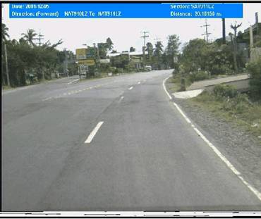
Figure 4 Sample Video Data for Philippine National Road Network
The data set obtained from the above survey is very large. It includes approximately 9,000 road sections, 8,000 nodes, 20,000 digital photographs, and 3,000 video files, as well as numerous database files. GIS provided the best mechanism for integrating all of the above data into a single environment and to enable spatial querying and analysis of that data. The Department used Esri ArcView 3.2 to manage and verify the survey data.
The Philippine National Road Network data is currently being made available to applications with embedded GIS.
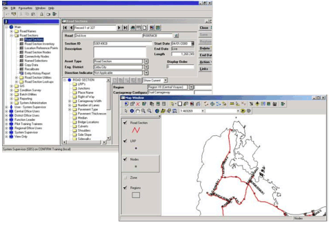
Figure 5 DPWH Road and Bridge Information Application with Embedded GIS
The Department has purchased and is implementing off-the-shelf applications that use Esri Map Objects technology to integrate the spatial and tabular data sources. Our Road and Bridge Information Application (see Figure 5) will enable accurate mapping of road and bridge inventory through dynamic segmentation on Esri shape files.
It also allows integration of all Road and Bridge data within a single database for use by other applications in future (see Figure 6).
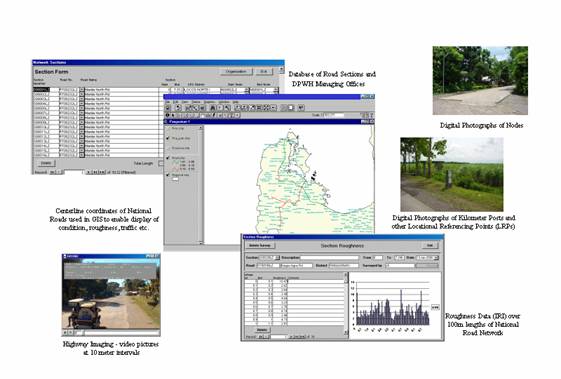
Figure 6 Integrating Data through Databases and GIS
The Department has plans to migrate this and other applications to use Esri ArcSDE in the near future.
The Department’s Enterprise Application Architecture and Enterprise Data Architectures (see Figure 7) place the Road Network and GIS as fundamental to many other applications.

Figure 7 DPWH Enterprise Application and Data Architectures
These include:
Road Traffic Information
Road Right of Way Management
Routine Maintenance Management
Multi-Year Planning and Scheduling
Strategic Network Planning
The Department is also implementing its enterprise GIS using Esri ArcIMS on its internal network. A web-based front end is being established to make data available to a wide number of users in Central and Regional Offices, including those in Planning, Design, Construction and Maintenance functions.
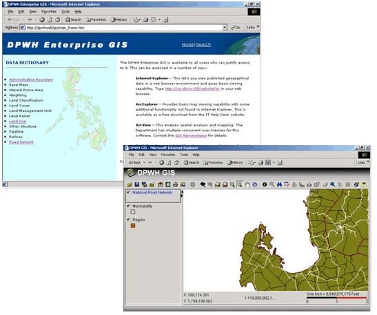
Figure 8 DPWH Enterprise GIS on the Internal Web
Web-based front ends dynamically make data available to users. It also makes extensive use of Esri’s metadata descriptions in XML (eXtensible Markup Language) to make the metadata easily available to users.
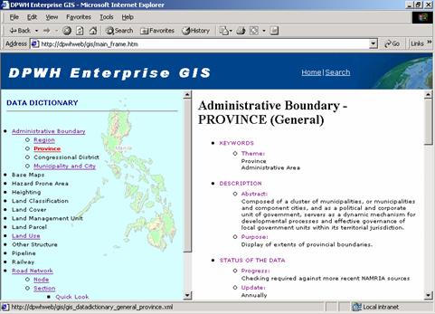
Figure 9 Metadata Available on the Internal Web
This makes it simple for the GIS administrators to communicate easily with end users regarding timeliness and accuracy of the data. Also included are known data problems, and timetables for future update.
A number of ArcIMS map services have been established, based on functional areas within the Department, including:
Administrative
Land Classification
Road Network
Socio-Environmental
Transportation (Other)
ArcIMS greatly eases the ability to make all of the Department’s spatial data available to staff who need to use it.
The long-term intention is to make selected map services available on the internet to DPWH’s customers, however there are no immediate plans to do this.
An accurate Locational Referencing System (LRS) is fundamental to the storage of all data for the Philippine National Road Network. Geographic Information Systems (GIS) are key to making this data available to all end users who need access to it. Recent developments in GIS data integration and internet map service technology are making deployment of these applications relatively straightforward.
On behalf of the Department of Public Works and Highways, I wish to extend my profound gratitude to Esri for inviting me and accepted my Paper No. 451 for presentation in the said conference.
I am also grateful for the support given to me by my co-authors in the preparation of this paper.
RIMSS (1999) Locational Referencing System (LRS) and Data Collection Report
RIMSS, Africon Coffey (2000) Procedures and Validation Report: Philippine Road Centerline Survey.
RIMSS (2000) LRS and Highway Infrstructure Data Report.
RIMSS (2000) Implementation Plan for Specialized Surveys: LRS/Data Collection BIIP.
RIMSS (2000) DPWH Enterprise Data Architecture
GIS Day 2000, Department-Wide GIS for DPWH
Engr. Luz V. Lagunzad
Engineer IV
Department of Public Works and Highway
Bonifacio Drive, Port Area
Metro Manila, Philippines
Tel. No. (632) 304-3470 or 304-3353
Fax No. (632) 304-3445 or 304-3033
Email address: lagunzad.luz.v@dpwh.gov.ph
Mr. Kevin McPherson
RIMSS Consultant
Department of Public Works and Highways
Bonifacio Drive, Port Area
Metro Manila, Philippines
Tel. No. (632) 304-3087
Fax No. (632) 304-3445
Engr. Gregorio P. Macaraig
RIMSS Consultant
Department of Public Works and Highways
Bonifacio Drive, Port Area
Metro Manila, Philippines
Tel. No. (632) 304-3088
Fax No. (632) 304-3445