Remote sensing for crop assessment
Author: Pat Daly, Franklin Conservation District
ABSTRACT
Annual crop acreage and aerial distribution data supports improved cultivation management practices in three counties in Central Washington’s Columbia Basin, where agriculture activities have been linked to elevated levels of groundwater nitrates. This paper presents a process developed to identify major crops on over two million acres during cultivation season using 30-meter Landsat-TM satellite images and GIS. Multispectral classification used field training sets, multi-temporal images, and over 31,000 field boundaries to classify thirteen crops. Classification accuracy was 84% overall, and exceeded 93% for several crops. Areas of relative leaching potential were determined using crop inputs to a Leaching Index.
1.0 Introduction
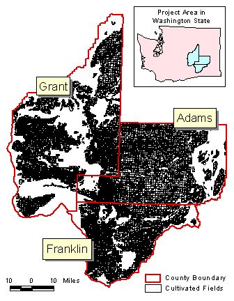
There are over two million cultivated acres in Adams, Franklin and Grant counties in eastern Washington (Figure 1.1). Approximately forty-three percent of these are irrigated and fifty-seven percent are dryland cultivation. The major crops include potatoes, wheat, alfalfa, corn, asparagus, apples and other specialty crops. Agriculture resource agencies assisting growers in management decisions and support would greatly benefit from an understanding of the number of acres in each type of crop, and the distribution of those crops within the cultivated acres. Some statistical information is available a year or more after a growing season, but very little specific crop data is available during a season, and crop distribution information is usually only detailed to the county-wide area.
A Geographic Information System (GIS) of cultivated acres in the three counties was developed in summer 2000 to support work by the Columbia Basin Ground Water Management Area (GWMA). The GWMA was formed in February 1998 to create a plan to reduce nitrate concentration in ground water in Adams, Franklin and Grant Counties. The GIS project included a one-time visual identification of 70% of crops growing in the cultivated acres during summer 2000.
The Washington Department of Ecology (WDOE) provided grant funds to the Franklin Conservation District to develop a process to distinguish the major crops in Franklin County using Remote Sensing (RS) technology. The objective was to create a process to identify major crops on an annual basis, at a reasonable cost. The database created for GWMA provided the base vector data (field boundaries) necessary to locate crop identifications, plus additional 2000 crop data to test satellite classification results.
The project began in February 2000 and coincided with GWMA’s GIS project through summer 2000. Image processing continued through the following winter, with support from researchers at Oregon State University. Franklin Conservation District completed classification of summer 2000 crops in Franklin County in August 2001. The process was applied to the 2001 season crops in all three counties beginning in May 2001 and draft classification results for the 2001 season were completed in October 2001.
The major process steps were: 1) limiting the crops to be classified; 2) identification of a sample of crops growing at the time a satellite image is being acquired; 3) acquiring and preparing the images, including determination of the best time period during the growing season and number of images to use per classification; 4) creating distinctive signatures of the sampled crops based on spectral histograms and plots; and 5) processing the classification, determining specific field classifications and creating a test matrix to quantify results.
The project will continue with a third year of crop classification in all three counties during summer 2002. Major objectives of the last year of the project will be to refine the field sampling process, determine the optimum number and acquisition times for the images, and improve the classification results.

 2.0 Project preparation
A major task of this project was defining the scope of work, the approach, and remote sensing technologies to employ. What constituted a ‘major’ crop? What level of image registration would be needed and how many images a season would be needed? What is the best software with regard to training requirements and project application? These were the first questions addressed, oftentimes with answers being refined well into the project.
2.1 Major Crops
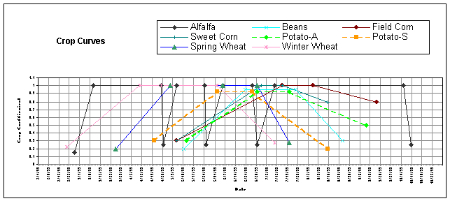
There are numerous crops and crop varieties being grown in Franklin County, many of them in rotation with other crops, either during a single season or over several seasons. The growth pattern of each of these varies considerably in terms of planting times, vegetation emergence, extent of vegetation cover through the season, and harvesting periods. An initial step to determine which crops could be distinguished using satellite images was made using a Crop Curve, comparing the crop water use coefficient to seasonal dates.
The Crop Curve was used to determine those time periods when there were major differences in vegetation growth between crops, thus increasing the software’s ability to distinguish between crops. The Crop Curve showed the likely periods when alfalfa would be cut, when wheat would be harvested, when potatoes would have full vegetation, and more importantly, when these periods occurred relative to each other. The first Crop Curve included 15 crops, including two varieties each of corn and potatoes. Figure 2.1 shows a second Crop Curve made using only 8 crops, attempting to better visualize the vegetation patterns of these crops.
Which crops to classify was also defined by economic importance, which related closely to yearly production acres and crop value. At a minimum, ten crops were to be classified: alfalfa, irrigated wheat, dryland wheat, potatoes, corn, asparagus, orchard, vineyard, Conservation Reserve Program (CRP) and dryland fallow. Other crops that would be added as possible were peas, onions and grass.
![]()
2.2 Image Processing
When this project was first proposed to DOE in spring 1999 the cost of Landsat-TM, 30-meter resolution images was $4400 for the scene covering Franklin County. The major advantage to TM images was the resolution and availability. Landsat-5 acquires images continuously, returning to the same location every 16 days. Since the onset of this project, Landsat-7 was launched and is collecting images on a similar 16-day schedule, offset from Landsat-5, so images are acquired by either Landsat-5 or Landsat-7 every 8 days. Control of image handling has also changed from private to government, reducing the cost to $600 per image.
Imagery with better resolution (1 to 20 meter) can be acquired, but not as readily as Landsat, and at a much greater cost. An added disadvantage to increased resolution is that the area of coverage decreases per image, again increasing the cost by increasing the number of images required. The average size of a field in the three counties is 40 acres for irrigated, and 125 acres in the dryland areas. A 30x30 meter pixel covers approximately 0.22 acres, sufficient to determine vegetation differences over the full size of cultivated fields.
Two remote sensing software packages have been used on this project. The classification process began with ENVI, produced by Research Systems Inc. This software provides extensive image enhancement and classification methods. The software had difficulty, however, processing the vast amount of vector data necessary for the size of area covered by this project. Imagine, produced by ERDASâ, was used to produce the final classifications, and has proven very capable of handling not only the area covered by Franklin County, but also the inclusion of Grant and Adams counties.
Image data contains records of the reflected radiance (light) from the earth’s surface in seven bands of the electromagnectic spectrum, one data value per band for each 30m2 pixel recorded. This project used Supervised Classification with multispectral images. Ground reference information was obtained by identifying a sample of the crops growing when the satellites were collecting images. Images were combined from at least two time periods, and the ground reference information was used to generate distinct spectral statistics (signatures) from the image pixel values, representing distinct crops.
Selection of images was based on information derived from the Crop Curves and the availability of cloud-free images.
2.3 Cooperating Agencies
This project was greatly supported by the efforts of Travis Smith of Titan Systems – AverStar Group, and Dr. Joseph Means and Brandon Fitt of Oregon State University. A grant from NASA Earth Science Enterprise provided to OSU allowed Dr. Means’ group to run a classification of Franklin county summer 2000 crops using data provided by the FCD. This work detailed many of the process steps and was referred to when the FCD completed their classification.
The FCD also worked very closely with Upper Grant Conservation District, Othello Conservation District, Adams Conservation District, and GWMA personnel to obtain field and map data in Adams and Grant counties.
3.0 Methods
3.1 Field Sampling
A subset of the fields to be identified was selected for ground reference information. Fields to be used as ground reference were selected based on size, location to a main road, and crop. A driving route along secondary paved roads was identified, and an initial drive in early May identified fields along the route that were greater than 40 acres, easily viewed from the road and contained (or were to contain) crops to be classified. Crops were identified in the same fields along this route each time a satellite was to be obtained.
The number of fields required as ground reference for satellite classification varies somewhat by crop, but refinement of the field sampling methods over the two years’ current work, indicates approximately 5-10% of the expected crop acres should be visually identified for use in image processing. This is necessary to account for the reflectance differences caused by crop species variability, differences in crop growth stages (caused by location and management decisions), and changes in crops through the season (double-cropping). Fewer number of fields are required for dryland crops because the fields are substantially larger, the variability within the field usually less, and there are only a few dryland crops to be classified.
Field sampling occurred as closely as possible to image acquisition date, but was not always exact. It took 1 to 2 days to complete the sampling route, using two people. Satellite acquisition dates are known, but it can be difficult to determine if the percent of clouds in the image will be low enough without seeing the actual image, which are usually available on the internet 3-5 days after they are taken by the satellite.
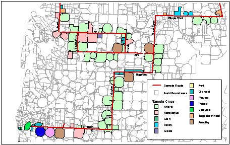
An ArcView shapefile was created of the sampled fields, and crop information added as part of the shapefile table, for each sampling period. Figure 3.1 shows a portion of the sample route used in Franklin County for summer 2001, and the crop identification of the fields along the route.
![]()
3.2 Images
Acquisition Dates
Table 3.1 identifies the image acquisition dates and sources for the 2000 and 2001 seasons. The optimum combination of image timing and number per season is still being clarified. Five image dates were selected the first year, covering only Franklin County, while three time periods were used for the second year, and coverage was extended to include Adams and Grant counties.
|
Image Date |
Satellite Source |
Image Extent |
|
February 16, 2000 |
Landsat-7 |
Path 44, Row 28 |
|
May 6, 2000 |
Landsat-7 |
Path 44, Row 28 |
|
July 9, 2000 |
Landsat-7 |
Path 44, Row 28 |
|
September 11, 2000 |
Landsat-7 |
Path 44, Row 28 |
|
October 13, 2000 |
Landsat-7 |
Path 44, Row 28 |
|
May 25, 2001 |
Landsat-7 |
Path 44, Row 28 |
|
June 18, 2001 |
Landsat-5 |
Path 44, Row 27 |
|
July 12, 2001 |
Landsat-7 |
Path 44, Row 28 |
|
July 12, 2001 |
Landsat-7 |
Path 44, Row 27 |
|
August 5, 2001 |
Landsat-5 |
Path 44, Rows 27 and 28 |
Table 3.1: Image Acquisition Dates
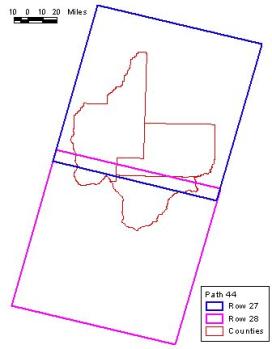
Landsat satellites acquire images along a designated path and row that provides images of known extent and location. Each image covers approximately 115 miles on a side (~13,200 square miles). Most of Franklin County is contained in the northeast portion of Path 44, Row 28, while all of Adams and Grant Counties, plus the remainder of Franklin County, are included in Path 44, Row 27. A single image of multiple, consecutive rows within the same path can be requested of images acquired on the same date.
![]()
Figure 3.2 shows the extent of each path/row, overlaid on the image of August 5, 2001, which is a single image combining both rows 27 and 28.
Pre-Processing
Depending on the processing level requested when the image is purchased, several steps were necessary to prepare the image for classification. The images are received individually – one image per band per image date. The bands to be used in classification (1-5 and 7) were combined to a single image and then clipped to eliminate portions of the image outside the county boundaries. Computer space and processing time are greatly reduced by clipping: the entire Path 44, Row 28 image with six bands is approximately 240MB; after clipping it to Franklin County, the size is ~56MB.
Each clipped image was referenced either to the fields vector file, or to a previously referenced image. This was done by finding reference points in the vector or image file that were easily identifiable and finding the same location in the image to be referenced. The 2001 images were referenced using a point file created in ArcView over 1996 one-meter DRGs. Points were created at road and bridge crossings, airports and other easily recognizable features, then their latitude/longitude identified. These values were used with a second-order polynomial transformation to create the referenced images.
Image Splits
The cultivated fields in Franklin County were classified in 2000; in 2001 Adams and Grant Counties were added to the land area to be classified. The land area of these three counties is over 2.1 million acres, and spans over 120 miles from southern Franklin County to northern Grant County. Crop growth patterns vary significantly from southern Franklin County to northern Grant County, due to later planting, growth and harvest dates in the northern portions of the area.
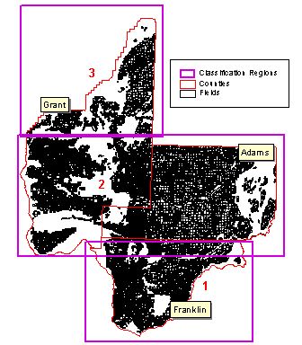
Classification of these crops using one classification signature seemed unrealistic with these conditions, so a decision was made to split the cultivated acres into three regions, and create classification signatures for each region. Figure 3.3 shows the three regions created for classification.
Several combinations of images from different time periods were tested to determine an optimum number and time period combination to produce the best classification. Referenced images from different time periods were combined to create single classification images. The May 25th and July 12th images were combined for classification of Region 1; June 18, July 12 and August 5 images were combined for Region 2 classification; and only the August 5th image was used for Region 3.
The classification results of these images are discussed below.
3.3 Classification
Classification was done with a Supervised Classification method, where the samples of field-identified crops were used to identify a given combination of pixel values as representative of different crop classes.
Creating Areas of Interest (AOIs)
AOIs are groups of image pixels that represent a known crop, or potential crop class, which are used to create parametric signatures for different classes. A parametric signature is based on statistical parameters (e.g., mean and covariance matrix) of the pixels that are in the training sample (those fields whose crop was identified). The process of creating signatures reviews the data values of the AOIs and consolidates groups of similar pixels to represent classes.
A portion of the sample fields were not used as training samples, but were set aside to be later used as a set of test fields to verify the results of the classification.
Two methods were used to create AOIs from the crop sample sets. Both used the vector files of the sampled crops, and both dealt with the problem of ‘edge effect’, the area at the edge of cultivated fields where the crop signatures are not pure, but mixed with the surrounding vegetation and/or roads, structures, etc.
The first method created a buffer around each sampled field polygon, essentially decreasing the size of the field from the edge. Both 45 and 60-meter buffers were used, subtracted from the original edge of the field polygon. This resulted in a smaller set of sample pixels, but eliminated the mixed pixels at the field edge.
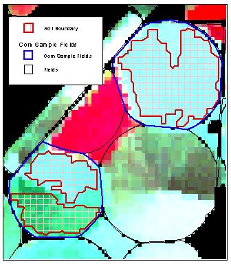
The second method used Imagine’s Seed Properties to select groups of contiguous pixels within the sample field boundaries. A single pixel was selected within a sample vector, and the software selected additional contiguous pixels based on specified parameters. This method minimized the loss of sample pixels, while reducing pixel value variability from both the edge pixels and those within the sample vector whose values resulted from crop growth variability within a field.
Figure 3.4 shows an AOI created through the Seed Properties over the sample vector. Each group of AOIs representing a single crop was added to the Signature Editor for refinement into crop signatures.
Signature Editor
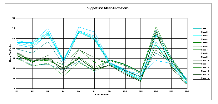
Classes generated from AOIs were evaluated using plots of the mean pixel values per band, and histograms of band data values. For example, in Franklin County 15 AOIs were generated from fields identified as corn in summer 2001. The signature editor (Figure 3.5) displays the number of pixels per class (Count), and the mean pixel value for each band (12 in a two-date image). Although these were each generated from fields identified as corn, significant variability is obvious, especially when the classes are viewed as a Mean Plot (Figure 3.6).
![]()
Figure 3.6: Signature Mean Plot, Corn AOIs
The first 6 bands are from the May 25th image; the second 6 bands are from the July 12th image. The differences in the first 6 bands can be attributed in this case to the condition of the fields in May, when a portion of them were likely either fallow (waiting for corn to be planted), had some residue from a cover crop, or were recently planted and had minimal growth. The height of B2-4 (Band 4 for the July image) indicates a fairly consistent vegetation cover in most of the fields.
A histogram of Band 4 for classes 1-4, plus 9, 13 and 15, shows a relatively normal distribution (Figure 3.7). In this example, the two similar groups of classes were each combined to make two final corn signatures used for crop classification. This situation was fairly typical of each of the major crops, with several of them having more than one signature in the final classification file.

Figure 3.7: Histogram of Band 4 for seven corn classes.
Refining the classes is an iterative process – looking at groups of classes, selecting combinations, reviewing their histograms and plots, adding and subtracting others, and reviewing again. An evaluation of separability between classes was made using several statistical methods at various stages of the refinement. A mean plot of the final signature file for Franklin County is shown in Figure 3.8.
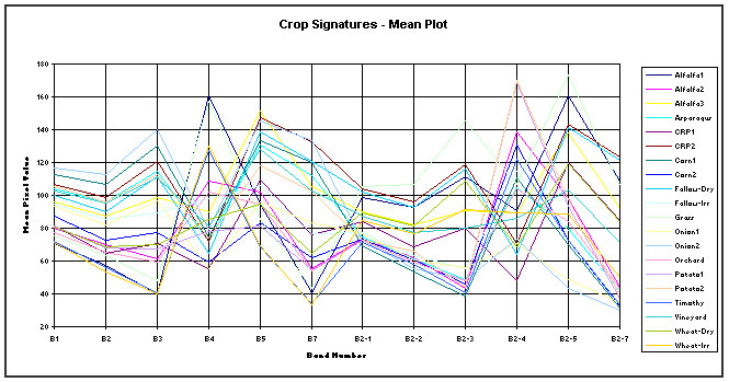
Figure 3.8: Mean
plot of Signature File, Franklin County Summer 2001.
Classify Rules
Classification was done for each region of the image using the signature file created for that region. The Maximum Likelihood decision rule was used for classification. This rule is based on the probability that a pixel belongs to a particular class. It also allows the use of assigning different probabilities for different classes, which was used during the classification process for regions one and two. In region one, the probability of the vineyard class was reduced significantly relative to the remaining classes because without the use of probabilities, a large portion of misclassified pixels were classified as vineyard. In region two, probabilities were used to help distinguish grass from alfalfa, whose signatures were very similar. Knowledge about the farming in central Grant County indicates there is much more alfalfa grown than grass. Results were greatly improved in both cases using probabilities.
A new, thematic image was created for each classification run, with pixels assigned to one of the crop classes from the signature file.
Field Classification
To determine a classification for each cultivated field, the majority class of the pixels within each field boundary was extracted with a zonal statistics command. The command also provided the majority fraction – what percent of the pixels made up the majority class. The field was initially assigned a specific crop based on the majority, but that was later refined by reviewing the majority percent, as described below.
3.4 Classification Results
Error Matrix
An Error Matrix was created each time a classification was run. The error matrix is a spreadsheet that expresses the number of sample units (field polygons) assigned to a particular category relative to the actual category observed in the field. Error matrixes were created for each region from several sets of data – all sample fields, just the sample fields set aside for test sets, and groups of fields with known crops from other FCD projects. Table 3.2 is the Test Matrix for Region 1, using only those fields set aside to test the classification results.
In this example, a total of 12 potato fields were set aside from the original field sample, to be used as test fields. Eleven of these were classified with one of the two potato signatures, resulting in 95% accuracy for the potato crop. Several crops (asparagus, grass, onion, grape, and timothy wheat) had less than 5 fields set aside as test fields. Removing these from the Test Matrix changed the overall accuracy only slightly – to 86%.
Classification Refinement
Several refinements were made for the final classification. First, the results were tabulated and compared with crop acreage totals from the field surveys of 2000 and discussed with District personnel familiar with field conditions. A major fault with the classification is the lack of an ‘Other’ category. The Supervised Classification method classifies every pixel into one of the class categories.
Test Matrix - 2001 |
|
|
|
|
|
|
|
|
|
|
|
|
|
||
|
Section 1, Test Fields, May &
Jul images only, Prob. Of Vineyard=0.01 |
|
|
|
|
|
|
|||||||||
|
Signature |
Alfalfa |
Aspar |
CRP |
Corn |
Fallow |
Grass |
Onion |
Orch |
Potato |
Grape |
Wh-D |
Wh-I |
Wh-T |
Totals |
|
|
Alf-EL |
2 |
|
|
|
|
1 |
|
|
|
|
|
|
|
3 |
|
|
Alf-EE |
6 |
|
|
|
|
|
|
|
|
|
|
|
|
6 |
|
|
Alf-LL |
16 |
|
|
|
1 |
|
|
1 |
|
|
|
|
|
18 |
|
|
Asparagus |
|
3 |
|
2 |
|
|
|
|
|
|
|
|
|
5 |
|
|
CRP-Old |
|
|
2 |
|
|
|
|
|
|
|
1 |
|
|
3 |
|
|
CRP-New |
|
|
1 |
|
|
|
|
|
|
|
|
|
|
1 |
|
|
Corn |
|
|
|
|
|
|
|
|
|
|
|
|
|
0 |
|
|
Corn-Fallow |
|
|
|
4 |
|
|
|
|
|
|
|
|
|
4 |
|
|
Fallow-Dry |
|
|
|
|
5 |
|
|
|
|
|
1 |
|
|
6 |
|
|
Fallow-Irr |
|
|
|
|
|
|
|
|
|
|
|
|
|
0 |
|
|
Grass |
1 |
|
|
|
|
1 |
|
|
1 |
|
|
|
1 |
4 |
|
|
Onion-1 |
|
|
|
|
|
1 |
2 |
|
|
|
|
|
|
3 |
|
|
Onion-2 |
|
|
|
|
|
|
1 |
|
|
|
|
|
|
1 |
|
|
Orchard |
|
|
|
|
|
|
|
9 |
|
|
|
|
|
9 |
|
|
Potato-1 |
|
|
|
|
|
|
|
|
7 |
|
|
|
|
7 |
|
|
Potato-2 |
|
|
|
|
|
|
|
|
4 |
|
|
|
|
4 |
|
|
Vineyard |
|
|
2 |
|
|
|
|
|
|
3 |
|
|
|
5 |
|
|
Wheat-Dry |
|
|
|
|
|
|
|
|
|
|
4 |
|
|
4 |
|
|
Wheat-Irr |
|
|
|
|
|
|
|
|
|
|
|
4 |
|
4 |
|
|
Wh-Timothy |
|
|
|
|
|
|
|
|
|
|
|
|
|
0 |
|
|
Totals |
25 |
3 |
5 |
6 |
6 |
3 |
3 |
10 |
12 |
3 |
6 |
4 |
1 |
87 |
|
|
|
|
|
|
|
|
|
|
|
|
|
|
|
Tot. Correct |
74 |
|
|
|
96% |
100% |
60% |
67% |
83% |
33% |
100% |
90% |
92% |
100% |
67% |
100% |
0% |
85% |
|
![]()
The final crop results include all fields with minor crops, a mix of crops, or other cultivation not represented in the signature file. To accommodate this discrepancy an Other category was created and two groups of fields assigned to it: 1) all fields with a majority fraction less than 40% (<40% of pixels within the field boundary were classified as part of the majority class), and 2) all fields with less than 5 acres, since these usually represent a mix of several crops, or are used for equipment and/or crop storage.
After these steps, a final look at the crop distribution was made, and obvious errors were corrected. These were mainly crops that only occur in irrigated areas showing up in known dryland areas. Where possible, these were classified as a crop, but usually put into the ‘Other’ category. This was only done for a very small portion of the total cultivated fields.
4.0 Discussion
Classification of crops using satellite images over this area works well for some of the major crops, especially potatoes. However, the diversity and variability of crop variety and growing schedule limits the ability to accurately distinguish between others, particularly grass and alfalfa. Corn poses problems because it has a wide range of planting and harvest dates, as well as the variety of crops used as a double-crop with it during a season.
The best way to improve the results will be an improvement in the quality of the field samples, which is planned for summer 2002. The goal will be to sample a total of 10% of the 2001 acres in each of the major crops, and that the selected fields will be a minimum of 40 acres. The pattern of sample fields should also reflect crop growth, i.e., crops should be sampled in all areas they are known to be grown in, and perhaps more in the areas where they are concentrated.
Author Information:
Pat Daly, Franklin Conservation District; 1620 Road 44 N., Pasco WA 99301; 509-545-8546 x3; pat-daly@wa.nacdnet.org
