| Putting Richmond, Virginia on the Map with ArcIMS Applications |
|
Raymond Freeland
Steve Waldron
Abstract
To effectively deliver GIS and City database information to browser-based users, the city of Richmond needed an Internet mapping application developed. The project utilizes Esri’s ArcIMS and ArcSDE technology, GIS data and a live link to a data warehouse pulling data from multiple city legacy systems. The application will be used by the public and City of Richmond staff. Functionality modules include Permitting, Crime Reporting, Citizen Requests, Thematic Mapping of Parcel Information, Property Identification/Mapping and Ground Control Monuments Research. Robust querying and reporting tools will be part of the application. 
City of Richmond WebMapper
City of Richmond WebMapper
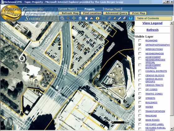
Municipal governments collect and control an astonishing amount of data. This data includes property characteristics, utility services, social services, business licenses, and retail sales information just to name a few. The City of Richmond, Virginia is committed to maximizing the accessibility of the data, not only for internal purposes but for public and business use as well. To this end, the city has followed the model used by large private sector industries and retailers adopting data warehousing and data mining strategies to manage their data. As the city developed their data warehousing strategy, disparate departmental data systems were linked to one another, and the data was integrated to the city’s Geographic Information System (GIS). The data warehouse, combined with GIS, allows the city to proactively redistrict political and school boundaries, plan better public transportation routes, strategically place utility services, and locate public facilities to best serve the different client bases. Public infrastructure projects could be planned that would have the best possible impact on property values. City services, such as road maintenance, signage, and weed control could be better targeted. In short, the data warehouse and the city’s GIS help city leaders make better policy and operational decisions, thereby enhancing the business environment across the city. While these tools are normally developed for internal city use, the decision was made to deploy as much of the data and functionality as possible to the public via the city’s GIS website. Working with the Louis Berger Group, the city GIS staff used Esri’s ArcIMS technology to create an advanced Internet GIS product - the Richmond WebMapper. Richmond WebMapper offers easy access to publicly available data, and allows the general public to use the same tools and datasets available to city planners or political leaders. The website is especially useful to community interest groups, neighborhood associations, professional firms, and individual citizens seeking any city collected information on properties or neighborhoods within the city limits. Richmond WebMapper provides access to information that can be grouped into two categories, geographic data layers and data warehouse information. The geographic data layers provide the mapping component of the application. The geographic data or “spatial data” answers the location questions for website users. An example is a real estate broker looking for commercial space within the city. Using the WebMapper application, users can query different parts of the city to find where commercial property is located. WebMapper users will be able to access and analyze all available city GIS mapping layers including streets, street intersections, council districts, census blocks, zip codes area, traffic zones, water features, transportation infrastructure, railroads, zoning information, buildings, parcels, aerial photographs and many others. The data warehouse information allows users to access and analyze data from various city departments. This information is regularly extracted from different departments within the city, address-validated, and made available at a single point of access, the data warehouse. Currently available in the data warehouse is city property assessment information, city central address data, zoning data, incentive zone information, planning information and various land use data. Upcoming data releases will be code enforcement data (building and environmental), permit data (building, demolition, etc.), and crime data. The data warehouse will be expanded to include this data as the program continues and moves forward. Richmond WebMapper represents the cutting-edge of GIS and data warehousing technology. As of the release date of the application, it offers several capabilities that are unique in the industry, including:
Other Richmond WebMapper capabilities include:
The Richmond WebMapper was developed so that the public could access city data that had been previously unavailable to either city staff or the public. Prior to the development of the Richmond WebMapper, a cross-departmental data request would have typically taken weeks to fulfill, and at a high cost of staff time and executive coordination across departmental lines. Data analysis requests that were previously impossible to fulfill or those that would have taken weeks or days, can now be done in minutes or seconds. Richmond WebMapper, along of the rest of the city GIS program, is designed to promote better policy and operational decision-making by city leadership. At the same time, Richmond WebMapper can be used by the private sector to access the tremendous wealth of data that the city collects to assist to their business ventures. As always, the city is committed to sharing its resources to help the business community advance. Available to the public 24 hours a day --7 days a week, free of charge-- Richmond WebMapper is available on the Internet at the following address:
Authors
Raymond Freeland, Director of Geospatial Information Systems The Louis Berger Group, Inc. 1819 H Street, NW Washington, DC 20006 (202) 331-7775 (202) 293-0787 (fax) rfreeland@louisberger.com Steve Waldron, GIS Coordinator City of Richmond 900 East Broad Street, Room 1100 Richmondm, Virginia 23219 (804) 646-3215 waldrosr@ci.richmond.va.us |