California
Department of Transportation GIS/Level of Service Application
Carlos P. Yamzon
Ty Phimmasone
ABSTRACT
This GIS application utilizes ArcView 3.2
Avenue programming to perform Highway Capacity Manual (HCM) capacity and levels
of service analysis methodologies for freeways, multi-lane highways, and
two-lane rural highways on the entire or selected segments of a Regional
Traffic Model network. Using the ArcView and TP+ Plus/Viper software interface
capabilities, a traffic model is converted to a shapefile and analyzed in the
ArcView environment. This application demonstrates a GIS/Traffic Model/HCM
Interface capability that streamlines the process of impact analysis on highway
projects and local development.
INTRODUCTION
Transportation Planners
utilize traditional, four-step models to translate indicators
of travel demand developed from land use information to distribute, and assign
trips to paths on highway or transit networks. The use of transportation models
to support long-term planning activities associated with the development of
Regional Transportation Plans (RTP), or other elements of long range
improvement plans, has been an important tool in Transportation Planning.
The advances in
computer technology have literally brought the four-step model, out of the
“black box” syndrome, and many commercial packages include very advanced ‘state
of the art” graphics capabilities that allow the user to develop very
sophisticated network maps, within the program itself. Even with this
improvement, many transportation modeling programs still include a GIS module
that allows the integration of the transportation network with a GIS map. This
allows the user to create a shapefile, and combine the analytical dynamics of a
transportation model with GIS technology, to further enhance viewing,
analyzing, processing, and presentation capabilities.
BACKGROUND
The California
Department of Transportation (Caltrans) GIS/Level of Service Application was
initiated as a pilot project funded by a Federal grant through Caltrans, to the
Merced County Association of Governments (MCAG), a San Joaquin Valley
Metropolitan Planning Organization (MPO).
The project focused on the development of interface capabilities between
the MCAG Regional Transportation Model, and their extensive Geographical
Information System (GIS) Program. The immediate applications of this interface
were to enhance the ability of Caltrans to use the model in the development of
traffic studies, in support of State Highway System (SHS) transportation
project development in
The traditional
traffic forecasting and analysis procedures performed by Caltrans staff,
entailed the use of the MCAG model as the source for future Average Daily
Traffic (ADT) volumes, but the more detailed portion of the traffic studies
required post-processing the majority of the remaining forecasting and
operational analysis work. This was necessary because the regional priorities
of the MPO model, and associated performance measures, did not translate
directly to project level measures of effectiveness, that included very
specific hourly traffic information, and adjustment factors required for the
design of SHS projects. In addition to this, the model was based on a 25 year
forecast consistent with MCAG’s Regional Transportation Plan (RTP), while
Caltrans projects, although based on a 20 year design, had varying starting
construction years, depending on transportation funding cycles.
OVERVIEW OF THE PROJECT
The California Department of Transportation (Caltrans) GIS/Level
of Service Application (CTGLA) utilizes
ArcView 3.2 Avenue programming to perform capacity and levels of service (LOS)
analysis methodologies for freeways, multi-lane highways, and two-lane rural
highways on the entire or selected segments of a transportation model network.
These methodologies are based on procedures documented in the 1997 Highway
Capacity Manual-Special Report 209 Third Edition (HCM). This GIS/LOS
application specifically accepts a shapefile created in the Viper (Visual
Planning Environment) program developed and distributed by the Urban Analysis
Group/Citilabs Company. The GIS Tools (Optional Add-On Module) in the Viper
program consist of a number of functions that allow the integration of the
transportation model network with a GIS map. The CTGLA accepts the shapefile
created by Viper, utilizing all available attributes of the transportation
network, as the information source to perform LOS analysis in the ArcView
environment.
Capacity analysis, is described in the 1997
Highway Capacity Manual- Special Report 209 Third Edition (HCM) as a set of
procedures for estimating the traffic carrying ability of facilities over a
range of defined operational conditions. The concept of level of service (LOS)
is also described in the HCM, as qualitative measures that characterize
operational conditions within a traffic stream and their perception by motorist
and passengers. Levels of service are generally given letter designations with LOS
A representing the best operating conditions and LOS F the worst.
Since this project was initiated, the HCM
has been updated with minor changes to the freeway and multi-lane highway
methodologies, and a completely new methodology of evaluating two-lane highways
by direction of travel or by both directions combined. Although the process has
started to update the Avenue programming, the CTGLA as presented at the 2002
Esri International User Conference, has not been modified to reflect the new
truck equivalency factors for freeway and multi-lane highways, or the new
methodologies for two-lane highways.
For the purpose of the CTGLA, the analyses
of three classes of roadways were selected. These were basic freeway segments,
two-lane highways, and multi-lane highways. These roadways represented
approximately 90 percent of the SHS in
The following examples identifies the
roadway information, including notes on items specific to the MCAG project
model, used in the Avenue programming, consistent with HCM methodologies for
the specific CTGLA project application:
DEFINITION OF CLASSES:
FREEWAYS- Interstate
5 and State Route 99
TWO-LANE HIGHWAYS- State
Routes 140, 152 thru Los Banos, 165, 59, 33
MULTILANES-
L.O.S. CALCULATION FOR FREEWAY:
- HEAVY VEHICLE FACTOR: FHV = 1 / [1 + Pt (Et – 1)]
1.
Et (Terrain
Factor) Look
up in TABLE 3-3
- PEAK HOUR DIRECTIONAL VOLUME: PHDV = Aadt * Ds * Factor
1.
Be cautious, the
Aadt is the “TOTAL” volume. For roadways that are split into single-directional
segments (in the cases of Interstate 5 and State Route 99) and the REV item is
equal to 1, then the adjacent pieces must be summed to produce this “TRUE”
Aadt.
- SERVICE FLOW: Sfe
= Msei * NoLanes * FHV
1.
If NoLanes = 2
(Per Direction) then Msei = 2200
2.
If NoLanes = 3
(Per Direction) then Msei = 2300
- CAPACITY: C
= PHDV / Sfe
- LEVEL OF SERVICE (L.O.S.): Look up in TABLE 3-1
- HEAVY VEHICLE FACTOR: FHV = 1 / [1 + Pt (Et – 1)]
1.
Et (Terrain
Factor) Look
up in TABLE 8-6
- ADJUSTMENT FACTOR: Fd; Look up in TABLE 8-4
- WIDTH FACTOR: Fw;
Look up in TABLE 8-5
- CAPACITY: SFx
= Sfideal (VCRSF) (Fd) (Fw) (FHV)
2.
VCRSF Look
up in TABLE 8-1 using %NoPassing & Type of Terrain
- LEVEL OF SERVICE (L.O.S.): Using thresholds from CAPACITY calculations at various
L.O.S.
L.O.S. CALCULATION FOR MULTILANE:
- HEAVY VEHICLE FACTOR: FHV = 1 / [1 + Pt (Et – 1)]
3.
Et (Terrain
Factor) Look
up in TABLE 7-7
- PEAK HOUR FACTOR:
4.
If “Rural
Highway” then PHF =
0.85
5.
If “Suburban
Multilane” then PHF = 0.92
- SERVICE FLOW RATE (pcphpl): vp = V / [(NoLanes) (PHF) (FHV)]
- MEDIAN TYPE FACTOR: Fm; Look up in TABLE 7-2
- LANE WIDTH FACTOR: Flw; Look up in TABLE 7-3
- LATERAL CLEARANCE FACTOR: Flc; Look up in TABLE 7-4
- ACCESS-POINT DENSITY ADJUST.: Fa; Look up in TABLE 7-5
- FREE-FLOW SPEED: FFS
= FFSi – (Fm + Flw + Flc + Fa)
- LEVEL OF SERVICE (L.O.S.): Look up in TABLE 7-1 using vp & FFS
The
following example describes the new List of Fields created for the ArcView
project application to recognize roadway attributes in the MCAG model.
LIST OF FIELDS
NEW FIELDS:
TRAFFIC
MODEL:
1.
A
2.
B
3.
Lanes # of lanes per direction
4.
TSVA (Speed) Speed
5.
V1_1 (Vol) Volume of traffic per
direction
6.
TOTV (Aadt) Total volume of traffic in both directions
7.
Name Designation of roadway names;
this will need to be revised for other counties, because currently, these names
are hard-coded (Interstate & State Routes) in the application.
8.
Numways (Rev) Directionality (either 1 or 3)
9.
Class This item could be used to
replace the “RTE” designation. The application could be revised (reprogrammed)
to look at “CLASS” (Freeway,
The CTGLA then accepts the transportation
model network as a converted shapefile, with the three identified roadway
classes already pre-defined in the attribute file of the model. The ArcView
program is launched normally and a series of validation screens are initiated
to verify that project information from a previous run is still acceptable, or
if new information will be used. This allows the user to provide additional
information consistent with any new changes that were made to the
transportation model, such as the addition of new network links, since the
previous run. After the project is updated the application begins to perform a
series of calculations associated with the identified roadway classes. At this point, the application will make a copy of the
“working” data layer ( <layer>_los.shp ). This copy will then be
modified, stripping out the nonessential fields and adding the new pertinent
L.O.S. items. Next, the values for these new L.O.S. items will be
calculated/determined using default figures. At this point the front-end L.O.S.
application dialogs will activate. The opening View (Figure 1) displays the map of
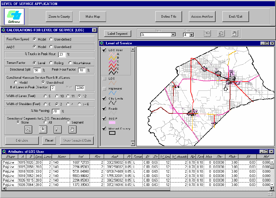
Figure 1. LOS Application
View with User Interface
Example of Level of Service Factors used for the re-calculation options:
1.
Free-flow Speed
2.
Annual Average
Daily Traffic
3.
Percentage of
Trucks
4.
Terrain Factor
5.
Directional
6.
Peak Hourly
Factor
7.
Conditional
Maximum Service Flow
8.
Number of Lanes
in Peak Direction
9.
Width of Lanes
(Feet)
10.
Width of
Shoulders (Feet)
11.
Percentage of No
Passing
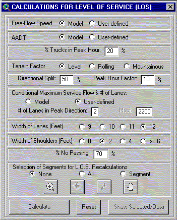
Figure 2. LOS Dialog Interface (inset from Figure 1)
LOS Dialog:
User Options For FREEWAY:
- FREE-FLOW SPEED 55,
60, 65, 70 mph
- AADT Not
constrained
- % TRUCKS IN PEAK HOUR Not constrained
- TERRAIN FACTOR Level,
rolling, or mountainous
- DIRECTIONAL
- PEAK HOUR FACTOR Not
constrained
- # LANES & MSEI 2 (Msei = 2200) or 3 (Msei = 2300) lanes per
direction
User Options For RURAL 2-LANE HIGHWAY:
- FREE-FLOW SPEED 35-70
mph
- AADT Not
constrained
- % TRUCKS IN PEAK HOUR Not constrained
- % NO PASSING Not
constrained
- TERRAIN FACTOR Level,
rolling, or mountainous
- DIRECTIONAL
- PEAK HOUR FACTOR Not
constrained
- WIDTH OF LANES 9-12
feet
- WIDTH OF SHOULDERS 0, 2, 4, 6+ feet
User Options For MULTILANE:
- MEDIAN Divided
or undivided
- REGION Rural
or suburban
- FREE-FLOW SPEED 45,
50, 55, 60 mph
- AADT Not
constrained
- % TRUCKS IN PEAK HOUR Not constrained
- TERRAIN FACTOR Level,
rolling, or mountainous
- PEAK HOUR FACTOR Not
constrained
- WIDTH OF LANES 10-12
feet
- WIDTH OF SHOULDERS 0, 2, 4, 6+ feet
- ACCESS POINTS Not
constrained
The application at this point
of the project maximizes the full potential of the ArcView program by allowing
the user to utilize the LOS Analysis Dialog to analyze the three pre-defined
SHS roadway classes, at the link, corridor, or network level. Any of the
conditional factors can be changed and re-calculated, reviewed, and even
displayed in a map.
At this point, if additional
information on the impacts to the entire network is desired, based on changes
made to a specific link or corridor, the shapefile must both be interfaced back
to Viper and re-run with the TP+ program. Another option would be to create a
new model run with new alternatives in the TP+Plus program, convert it back to
a shapefile and re-calculated in the CTGLA.
CONCLUSION AND NEXT COURSE OF ACTION
The California Department of
Transportation GIS Level OF Service Application demonstrated the benefits of an
existing and available integration of two types of systems, transportation
network models and GIS. The “user friendly” environment of the ArcView program
allows the transportation analyst to import a transportation model with all
associated network attributes and utilize the Highway Capacity Manual
methodologies to review, analyze, modify, and display calculations and results
with no additional post-processing activities between the three program
platforms. Although an intermediate knowledge of transportation modeling,
ArcView GIS, and HCM methodologies is helpful, ArcView users using this project
application can immediately utilize transportation model data and begin
performing HCM analysis, with minimal training in both programs.
The update of the LOS
methodologies to HCM 2000 is in progress, with consideration of also including
the analysis of interrupted flow facilities.
ACKNOWLEDGEMENTS
California Department of
Transportation
Division of Transportation
Planning
1.
Office of
Advanced System Planning
Division of Transportation
System Information
1.
Office of Travel
Forecasting and Analysis
1.
Office of GIS
District 10 Division of
Transportation Planning
REFERENCES
Publications
Urban Planning and
Development Applications of GIS
Edited by Said Easa and Yupo
Chan
Copyright 2000 by the
American Society of Civil Engineers
Highway Capacity Manual
Special Report 209
1998 by the Transportation
Research Board
National Research Council
Highway Capacity Manual
2000 by the Transportation
Research Board
National Research Council
Viper 2.0 Manual
2000 The Urban Analysis Group
/ Citilabs Company
TP+ 2.0 Manual
2000 The Urban Analysis
Group/Citilabs Company
Introduction to ArcView GIS
–Developed for Caltrans by Esri
1992-2000
Environmental Systems Research Institute, Inc.
AUTHOR INFORMATION
Name: Carlos P. Yamzon
Title: Senior Transportation
Planner
Organization: California Department
of Transportation
Address: Caltrans District 10
Telephone: 209-948-3975
Fax: 209-948-7194
e-mail: carlos_yamzon@dot.ca.gov