Sara J. Kidd
The Kingsport Economic Development Partnership (KEDP), located
in Kingsport, Tennessee, is utilizing GIS and the Internet to showcase available
industrial and office sites. The goal of the web-based GIS application is to
provide pertinent information about available properties in order to aid the
recruitment of new industries and businesses for relocation to the Kingsport
area. Visitors to the KEDP web site will be able to query the available locations
based on certain criteria. This will return a list of properties that meet the
criteria, the location on a map, and a link to a photograph of the property.
By providing an intuitive site-selection tool in a web-based format, the KEDP
will be able to attract a larger group of prospective recruits. The KEDP web-based
GIS application was developed using ArcIMS.
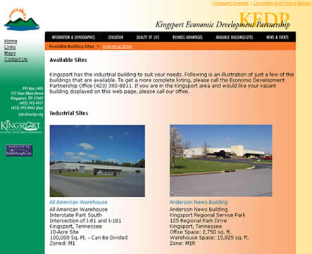
Kingsport, Tennessee is a community of 45,000 in a metropolitan area of 500,000 in northeastern Tennessee. The city is located at the intersection of I-81 and future I-26 (now I-181) near the geographic center of the eastern United States. The Kingsport Economic Development Partnership (KEDP) is comprised of the City of Kingsport, Kingsport Chamber of Commerce, the Kingsport Economic Development Board and private businesses. In its efforts to encourage economic development, the KEDP maintains a website which showcases the best aspects of Kingsport and the surrounding area. The website also provides a list of available industrial buildings, commercial/office buildings, and business parks to allow prospective developers to view information and photographs of the properties. However, this information is static and the web site visitor must click through several pages to see all of the properties (Figure 1).
In the past, on-site visits were the best way for site selection consultants to choose potential economic development sites. With the advent of the Internet, the initial selection process can now be conducted from a desktop. Realizing that the City of Kingsport should put its "best foot forward" in cyberspace, the KEDP decided it needed a more interactive web site. The KEDP contracted GeoDecisions to develop an ArcIMS application for the KEDP web site. In addition to the goal of enhancing the site selection process for potential developers, the KEDP also wanted the ArcIMS application to display the City's most up-to-date spatial data online for City employees and the public.

All of the data layers that are available in the ArcIMS application are maintained by the City of Kingsport's GIS Division. The City data layers that are available for viewing on the web site include: roads, parks, historical districts, water and sewer lines, traffic counts, urban growth boundary, parcels, census blocks, zoning, school districts, schools, hospitals, and fire stations. The parcel boundaries data layer was developed as a result of the Tennessee Base Mapping Program. This Project is a statewide effort to create a comprehensive digital base map for use in a GIS. The base map is comprised of digital orthophotos as well as a parcel database. A link to the Comptroller’s Computer Aided Assessment System (CASS) provides the necessary attribute information for the parcels. Sullivan County (where Kingsport is located) was one of the first counties in the state to receive their base map data.
The digital orthophotos, originally in TIFF format, were converted and mosaiced
into MrSID files to speed the transfer of the images in the ArcIMS application.
A new data layer containing the locations of the available properties was created specifically for the ArcIMS application by the GIS Division. Since the KEDP maintains the list of available properties as a simple spreadsheet, attribute information is stored in an Access database with a unique ID number that links to the available properties point shapefile. The shapefile will continue to be updated as new properties come on the market and others are sold.
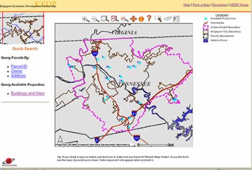
GeoDecisions built and customized the KEDP web application with the HTML viewer of ArcIMS (Figure 2). This viewer was chosen because of its robust "out-of-the-box" functionalities and because it maintains a thin client. When the web site is first visited, the user is required view the disclaimer and supply their ZIP code (or country), with the option of leaving a name and email address. With the ZIP code information, the City's GIS Division can geocode the location of web site visitors and provide a report to the KEDP. If a large number of visitors are coming from a particular part of the country, then the KEDP can investigate that area and perhaps arrange for an on-site visit.
Once the user enters the ZIP code, the ArcIMS application is launched automatically. The standard functions available on the web site include panning, zooming, identify, query, and print. However, since the focus of the web site is on available properties and the associated parcels, the KEDP required a more simple, user-friendly means to query the parcels and available properties data.

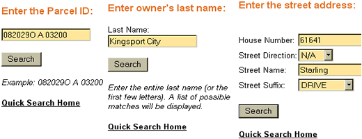
GeoDecisions created a "Quick Search" panel that allows the general public and potential new developers to search the parcels data layer by Parcel ID, Owner Name, or the Address of the parcel . There are no complicated queries to construct - just simple text boxes in which to enter information. Once the user enters a search parameter, ArcIMS queries the underlying shapefile, returns a table of possible matches, and zooms to the parcels that meet the criteria. The default query function available in the ArcIMS application is targeted for the more advanced user. The standard query tool allows the visitor to query any of the data layers in the ArcIMS application by constructing query statements.

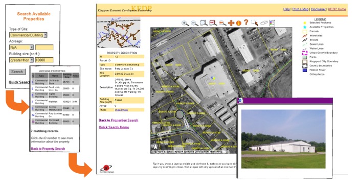
The highlight of the new KEDP ArcIMS application is the ability to search the available properties based on category (industrial, commercial, etc.) as well as by site acreage and building square footage. When the user enters the search parameters, the Access database is queried and returns a list of possible matches. From that list, the user clicks the property of interest which then displays the detailed property information and zooms the map to the property site. The user also has the option to view a photograph of the property (Figure 4).

The other data layers available in the ArcIMS application can help give the prospective developer a better sense of the location. For instance, the interested party could turn on the census information to view demographics of the neighborhood, find out if there is water or sewer present on site, or identify the zoning for that parcel.
GeoDecisions also created a comprehensive help document for the ArcIMS application. The help document describes how to use each of the tools, the Quick Search, and how to manipulate the data layers (changing visibility, setting active layer, etc.). It also describes how to use the more advanced query
GeoDecisions will host the KEDP ArcIMS application on its corporate servers for a term of one year. After that time, the City of Kingsport GIS Division will install and maintain the application on its own servers.
The Kingsport Economic Development Partnership invested in a high quality, affordable, interactive website designed to portray the city's best attributes in cyberspace. The result is a simple, yet powerful spatial tool that potential developers can use to do an initial investigation of sites without making a visit in person. An additional benefit of the application is that the City of Kingsport's most commonly requested GIS layers are viewable online in their most current state. Other City departments and the public are now able to view and query the GIS data through their own desktop without having to install any software. As an added bonus, the availability of GIS data in the ArcIMS application has reduced the number of requests the GIS Division receives for printed map products. This allows them to concentrate on keeping the GIS database current.
Author
Sara J. Kidd, Web Developer
GeoDecisions
"Bringing the Power of Spatial Information to the Enterprise"
11838 Rock Landing Drive, Suite 200
Newport News, Virginia 23606
757-873-0768
skidd@geodecisions.com
http://www.geodecisions.com