The Ecosystem Management Decision Support (EMDS) system version 3.0 is an ArcGIS 8.1 extension that provides integrated, multiscale decision support for evaluation of landscape condition and setting priorities for management activities.
The Ecosystem Management Decision Support (EMDS) system is an application framework for knowledge-based decision support of ecological assessments at any geographic scale. The system integrates state-of-the-art geographic information system (GIS) as well as knowledge-based reasoning and decision modeling technologies in the Microsoft Windows® (hereafter, Windows) environment to provide decision support for a substantial portion of the adaptive management process of ecosystem management. Appendix A defines terms and key concepts related to knowledge-based reasoning with fuzzy logic (Zadeh 1965, 1968, 1975a, 1975b, 1976).
EMDS version 3.0 was developed for the USDA Forest Service under contract with Esri to provide decision support for landscape analysis. The initial release, in February 1997, integrated logic processing of landscape information, based on the NetWeaver fuzzy logic engine (Rules of Thumb, Inc.), into the ArcView GIS environment (Reynolds 1999). EMDS version 3.0 is a major re-engineering of the system for the new ArcGIS 8.1 COM-based technology and Windows 2000. Version 3.0 extends the original scope of the EMDS application to include integrated planning functions provided by the Weighted Decision Object, an engine by InfoHarvest that implements the analytic hierarchy process model (AHP; Saaty 1992, 1994) for setting priorities, selecting alternatives, and allocation of organizational resources. Appendix B defines terms and key concepts related to the AHP
The evaluation and planning features of EMDS version 3.0 will be illustrated with an integrated, multi-scale example of evaluating salmon habitat potential in stream reaches and watersheds and establishing priorities for protection and restoration of stream reaches and watersheds, based on results of the landscape evaluations and additional considerations of restoration efficacy and feasibility. Appendix C provides a summary of major system enhancements in version 3.0.
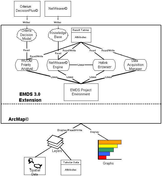
The EMDS component diagram illustrates the basic architecture of EMDS 3.0 and the flow of information among system components. Note that NetWeaver Developer (Rules of Thumb) and Criterium DecisionPlus (InfoHarvest) are external development tools needed to create knowledge bases (logic models) and decision models, respectively. EMDS 3.0 is comprised of the following six major components:
|
|
|
ArcMap is the spatial processor that executes spatial overlays, table joins, and provides other sophisticated GIS functionality. Rendered as an ArcMap extension, EMDS takes advantage of ArcMap's data management operations to perform all the processing required to prepare NetWeaver input tables. Results of an EMDS assessment are displayed in ArcMap's data view, graphs, and tables. |
The EMDS ArcMap extension provides the primary system interface in which an assessment team:
|
A single EMDS project may contain multiple scales of landscape assessment, an assessment may contain multiple analyses, and analyses may contain multiple scenarios. Consequently, the total project structure may become relatively large and complex. To facilitate creation and management of projects, version 3.0 adds an EMDS pane to the ArcMap table of contents, and this pane represents the complete project structure in a collapsible outline view. |
Knowledge base processing in EMDS is performed by the NetWeaver engine. Data input to the engine is mediated by the EMDS Project Environment and ArcMap. Knowledge bases that describe logical relations among ecosystem states and processes of interest in an assessment are created in NetWeaver Developer.
The original EMDS design team selected the NetWeaver knowledge base engine in particular for integration into EMDS because of its implementation of fuzzy logic-based reasoning. Compared to classical rule-based systems (Waterman 1986), knowledge representation for problem specification using fuzzy logic is more precise, compact, and efficient. Moreover, we were convinced that the combination of propositional logic networks with fuzzy logic-based reasoning as implemented in NetWeaver would make knowledge-based solutions to ecological assessments far more feasible than classical methods due to its implementation of object-based design (Booch 1994) and consequent support for evolutionary design of complex system specifications (Gall 1986).
The NetWeaver logic engine evaluates data against a knowledge base that provides a formal specification for the interpretation of data. A knowledge base can be thought of as a type of meta database. EMDS application developers use the NetWeaver Developer System (Rules of Thumb, Inc.) to design the knowledge bases used in EMDS. The logic engine allows partial evaluations of ecosystem states and processes based on available information, making it ideal for use in landscape evaluation where data are often incomplete. The NetWeaver engine was selected as the core logic processor of EMDS because its associated development system readily supports design of logic specifications for the types of large, complex, and abstract problems typically posed by ecosystem management.
|
A second key feature provided by the logic engine is the ability to evaluate the influence of missing information on the logical completeness of an assessment. The engine, in conjunction with the EMDS Project Environment and the Data Acquisition Manager, provides powerful diagnostic tools for determining which missing data are most valuable given currently available data and for determining how much priority to give to missing data given other logistical information. |
After map output for an analysis has been displayed in ArcMap, the Hotlink Browser can be used to view the evaluated state of NetWeaver logic models for selected map features. The graphic display of the evaluated state of a knowledge base is relatively intuitive, and provides a detailed explanation of the derivation of evaluations that is extremely valuable to EMDS developers, users, and the general public.
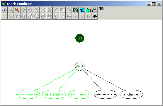
Sophisticated geographic analyses often produce impressive looking maps. However, if the analytical system that produces a map cannot also explain the derivation of analysis results being portrayed in a relatively simple and straightforward way, then the system appears to observers as a black box. With the high level of public interest in natural resource management in these times, black box solutions are a political liability. Using the Hotlink Browser, users can navigate the networks of analysis topics to trace the logic of evaluations in an intuitive interface. More importantly. the presentation of results in this graphic format is sufficiently intuitive that users of the system can use the Hotlink Browser as a powerful communication tool that effectively explains the basis of evaluation results to broad audiences.
Data gaps are common, particularly in the early stages of landscape evaluation. It turns out that, from a logic perspective, the influence of missing information is very dynamic. The Data Acquisition Manager (DAM), in conjunction with the NetWeaver logic engine and the EMDS Project Environment, summarizes the influence of that missing information, given the information that is currently available, and assists the user with establishing priorities for obtaining the missing data to improve the logical completeness of an assessment in the most efficient way. A variety of maps, tables, and graphs provide useful information about what data are missing, the influence of missing data on completeness of the assessment, and how it is distributed in the landscape.
Previous versions of EMDS only performed landscape evaluations. The PA is a dynamic decision tool that extends the functionality of EMDS to include integrated planning. The PA can be used for priority setting, resource allocation, and trade-off analysis once a landscape analysis has been completed. Just as the Hotlink Browser provides powerful explanation facilities for understanding evaluation results, PA includes a variety of diagnostic tools that help developers, users, and the general public understand the basis for resultant planning priorities.
Whereas the logic engine addresses questions about the current state of the assessment area, PA addresses questions about where to direct management for best effect. For most applications of evaluation and planning, maintaining this distinction is important because the landscape elements in poorest condition are not necessarily also the best candidates for management activities such as restoration for example.
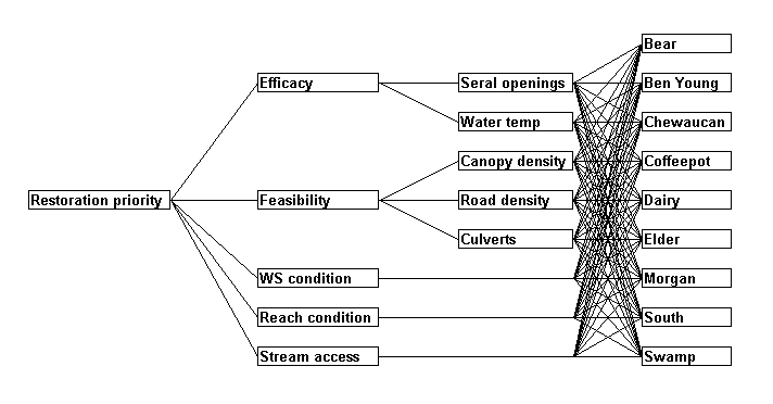
PA is a Multi-Criteria Decision Analysis (MCDA) component that assists resource managers in ranking landscape elements based on how well each rates against a set of decision criteria. Using output from a landscape evaluation and a decision model designed in Criterium DecisionPlus (InfoHarvest), PA rates the landscape elements not only with respect to their condition, but also with respect to factors related to the feasibility and efficacy of management. PA implements two decision models: the Analytic Hierarchy Process (AHP; Saaty 1992, 1994) and the Simple Multi-Attribute Rating Technique (SMART; Kamenetzky 1982).
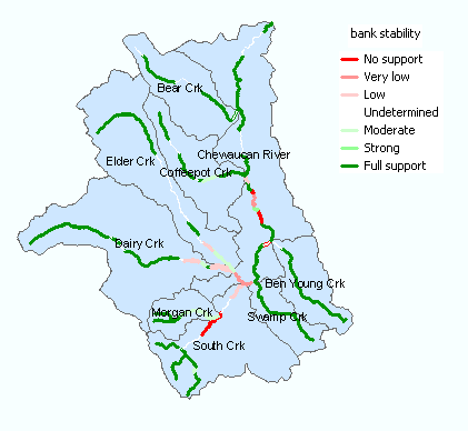
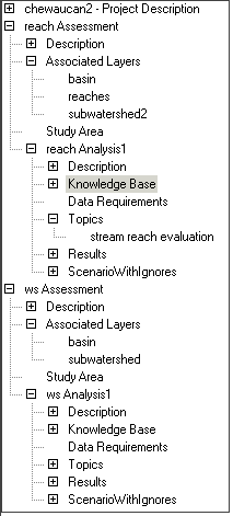
The Chewaucan Basin is in located on the Fremont National Forest in southcentral Oregon. The Chewaucan EMDS project contains two assessments. The first assessment evaluates stream reach condition for all mainstem reaches within the Chewaucan basin. The second assessment evaluates the condition of the subwatersheds that make up the Chewaucan basin.
|
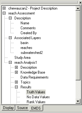
Project StructureEach assessment is defined by its study area and a set of associated layers. In this example, there is a reach-level and a subwatershed level assessment. Assessments may contain one or more analyses. An analysis is defined by the knowledge base with which it is associated. Separate analyses within an essessment may be desirable to evaluate different knowledge bases that use different combinations of an assessment's associated layers. After a user associates a knowldge base to a new analysis and selects one or more topics for analysis from the knowledge base,
Input data and knowledge base structure cannot be edited in an analysis. This read-only feature of analyses is enforced to assure data integrity. However, users can create one or more scenarios in which both data and some aspects of knowledge base structure can be modified either to tune the analysis or explore alternative conditions and hypotheses about the state of the landscape. |
Given an analysis or scenario, users can
First, consider how two scales of assessment may be linked with each other in some manner. Each knowledge base is relatively scale-specific because the nature of the questions to be posed (or topics to be evaluated) and the way in which they are answered tends to change with scale.
In the context of the Chewaucan assessment, two scales are of interest: the reach and subwatershed scales, and the project contains a knowledge base for each scale. In EMDS, the concept of knowledge bases as networks of topics is extendable to assessments. That is, we can think of assessments as providing formal specifications for the evaluation of networks of knowledge bases when the basic assessment problem suggests the need for multiple scales of evaluation. This is a very simple, but powerful, idea. While the Chewaucan example is limited to two linked scales of evaluation, the idea is easily extended to multiple scales, and there is no requirement that scales be hierarchically nested. Thus, we can think of networks of knowledge bases as opposed to hierarchies of knowledge bases.
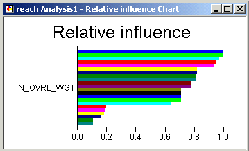
So, how could specifications be developed for linking scales? The basic approach requires summarizing information from one scale in a manner that makes the information applicable at another scale. In general, some sort of transformation of information is needed when moving information from one scale of evaluation to the next. In the Chewaucan assessment, for example, evaluations of reach condition are summarized by subwatershed as the length-weighted average of reach condition results, and the length-weighted average results are provided to the attribute table of the subwatershed layer.
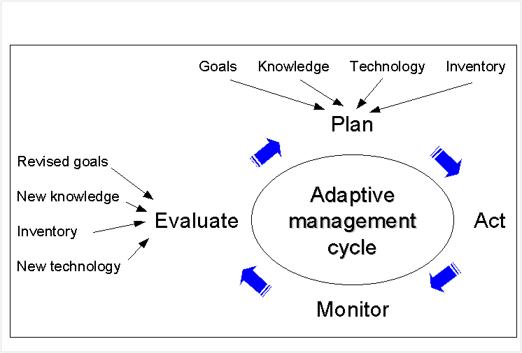
Since its inception, a longterm goal of EMDS system development has been to provide effective decision support for the complete adaptive ecosystem management process (AEMP).
Versions 1.0 and 2.0 focused on delivery of knowledge-based decision support for landscape evaluation. Use of the NetWeaver logic engime in these versions allowed tackling the large, abstract, and complex questions that are now typically posed in the context of ecosystem management. Feedback from the EMDS user community consistently has validated the original development team's belief that a fuzzy logic-based approach, that could evaluate incomplete information and the influence of information, would be extremely useful for landscape evaluation. The logic specifications developed for evaluation also, in a sense, provide a backdoor into the monitoring phase of the AEMP.
In version 3.0, the complete re-engineering of EMDS into a COM-based application also afforded the opportunity to significantly extend the system's support of the AEMP through integration of the new Priority Analyst component that supports the planning phase of the process. While version 3.0 represents a significant step in the evolution of the EMDS design, there is still considerable room for continued development. Potential major enhancements in the next iteration of development include:
Basic concepts of approximate reasoning with fuzzy logic were first presented by Zadeh (1965, 1968). Subsequent concept papers (Zadeh 1975a, 1975b, 1975c) elaborated on the syntax and semantics of linguistic variables, laying the foundation for what has now become a significant new branch of mathematics. Fuzzy logic is concerned with quantification of set membership and associated set operations. Formally (Kaufmann 1975), let E be a set, denumerable or not, and let x be an element of E. Then a fuzzy subset A of E is a set of ordered pairs {x, A(x)}, x E, in which A(x) is a membership function that takes its values from the set M = [0, 1], and specifies the degree of membership of x in A. Because fuzzy set theory is a generalization of boolean set theory, most boolean set operations have equivalent operations in fuzzy subsets (Kaufmann 1975, p. 11).
Application of fuzzy logic to natural resource science and management is still relatively new. General areas of application include classification in remote sensing (Blonda 1996), environmental risk assessment (Holland 1994), phytosociology (Moraczewski 1993a, 1993b), geography (Openshaw 1996), ecosystem research (Salski and Sperlbaum 1991), and environmental assessment (Smith 1995, 1997). More specific applications include catchment modeling (Anonymous 1994), cloud classification (Baum et al. 1997), evaluation of plant nutrient supply (Hahn et al. 1995), soil interpretation (Mays et al. 1997, McBratney and Odeh 1997), land suitability for crop production (Ranst et al. 1996), ecological site classification (Ray et al. 1998), watershed assessment for total maximum daily load of non-point source pollutants (Reynolds et al. 1999), and biodiversity system design (Bourgeron et al. 2000).
There are three basic parts of a knowledge-based reasoning system:
In EMDS, the user builds a knowledge base in NetWeaver Developer that describes the problem domain. Performing an assessment entails running the inference engine on the knowledge base by means of another interface that is integrated with the EMDS ArcMap extension.
In the future, assessment teams may be able to assemble a list of all topics they want to include in an assessment, assemble a list of data requirements needed to address those topics, and find they have all the required data. In the meantime, however, assessments routinely need to deal with incomplete data. There may be some missing observations for several to many data types. There may be no data at all for (possibly) many others.
One solution to the problem of missing data is to tailor an assessment to existing data. However, this is a poor way to conduct an assessment of environmental phenomena with complex inter-relations because it is extremely difficult, if not impossible, in such an approach to infer what is not known about the data that might be relevant and how influential it might be for completing an analysis of ecosystem states and processes. Instead, it is preferable to construct a model that reflects our best understanding of how all states and processes relevant to the assessment are inter-related. The NetWeaver engine incorporated into EMDS uses a simple algorithm to compute the influence of missing data based on the logical structure of the knowledge base, how many states and processes use the information, and at what level the information enters a knowledge base structure. The Data Acquisition Manager (DAM) in EMDS uses information about data influence to assist users with prioritizing new data acquisition needs.
A knowledge base embodies knowledge about how to solve a problem in some domain of interest. Several different approaches to knowledge-based representation have been developed over the last 30 years (Schmoldt and Rauscher 1995). EMDS incorporates the NetWeaver logic engine for knowledge-based reasoning (Saunders and others 1990, Stone and others 1986). This system implements a knowledge base as hierarchies of dependency networks. By itself, a knowledge base doesn't actually do anything. The knowledge base that an assessment team constructs with NetWeaver is best thought of as a meta database. It is used to interpret data processed by the inference engine.
Knowledge-based reasoning (or equivalently, symbolic reasoning) is a general modeling methodology in which phenomena are described in terms of abstract entities and their logical relations to one another. There are two basic reasons for using knowledge-based reasoning:
Both cases are quite common in environmental sciences. The first case naturally arises when the nature of the problem involves inherently abstract "things." Such problems may simply be easier to solve with logic. The second case arises frequently because, particularly when dealing with natural systems, there is an almost unlimited number of relations potentially of interest. Agencies, academia, and others have developed numerous mathematical models to describe some of the important relations of interest to ecosystem management, but many relations have not been studied in adequate detail to provide sufficiently general mathematical models. However, there is often a wealth of human experience in these same institutions that can be drawn upon to develop useful, more qualitative, knowledge-based models to guide decision making. One other very valuable aspect of symbolic reasoning that makes it ideal for use in ecological assessment is that such systems can reason with incomplete information. The NetWeaver engine provides partial evaluations of ecosystem states and processes based on available information, and provides useful information about the influence of missing data which can be used to improve completeness of an assessment.
A multi-criteria decision problem generally involves choosing one of a number alternatives based on how well those alternatives rate against a chosen set of structured and weighted criteria (the decision model). The criteria themselves are weighted in terms of importance to the decision maker, and the overall score of an alternative is the weighted sum of its rating against each criteria. The ordering of the alternatives by their decision scores is a prioritized ranking of those alternatives by preference. Decision analysis provides a number of analytic tools, such as sensitivity analysis and tradeoff analysis that validate the reasonableness and robustness of a given decision model.
Two primary decision-making methodologies in use are the Analytical Hierarchy Process (AHP; Saaty 1992) and Multi-attribute Utility Theory as implemented in the Simple Multiattribute Rating Technique (SMART; Edwards 1977, Edwards and Newman 1982).
The Analytic Hierarchy Process allows users to assess the relative weight of multiple criteria (or multiple alternatives against a given criterion) in an intuitive manner. Its major innovation was the introduction of pair-wise comparisons - research showed that when quantitative ratings are unavailable, humans are still adept at recognizing whether one criteria is more important than another. AHP employs a consistent way of converting such pair-wise comparisons into a set of numbers representing the relative priority of each criteria.
A potential drawback with AHP: Rank Reversal. Because judgments in AHP are relative by nature, changing the set of alternatives may change the decision scores of all the alternatives. It has been shown that even if a new, very poor alternative is added to a completed model, those alternatives with top scores sometimes reverse their relative ranking.
In the Simple Multi-Attribute Rating Technique, ratings of alternatives are assigned directly, in the natural scales of the criteria (where available). For instance, when assessing the criterion "top speed" for motor cars, a natural scale would be from 100 to 200 miles per hour. In order to keep the weighting of criteria and rating of alternatives as separate as possible, the different scales of criteria need to be converted to a common internal scale. In AHP this is taken care of by the relative nature of the rating technique. In SMART, it is done mathematically by the decision-maker by means of a value function. The simplest choice of a value function is a linear function, and in most cases this is sufficient. However, to better allow for human psychology in decision making, it is often advantageous to use nonlinear functions. Utility Theory offers a deep and complex literature for choosing a value function.
Advantage: The decision model is independent of the alternatives. While the introduction of value functions somewhat complicates the decision modeling process, the advantage is that the ratings of alternatives are not relative, so that changing the number of alternatives considered will not, in itself, change the decision scores of the original alternatives.
Major enhancements in EMDS version 3.0 include:
The PA is a powerful new decision tool for planning that uses Criterium DecisionPlus' (InfoHarvest) decision modeling engine for the analytic hierarchy process (AHP) and the simple multi-attribute rating technique (SMART). Planning features implemented by PA include priority setting, resource allocation, alternative selection, sensitivity analysis, explanation of priority derivations, and trade-off analysis. With PA integration, users can more or less seamlessly step from landscape evaluation into landscape planning.
The use of trade or firm names in this publication is for reader information and does not imply endorsement by the U.S. Department of Agriculture of any product or service.
Anonymous. 1994. Fuzzy logic applied to catchment modelling. Water & Wastewater International 9:40-43.
Baum, Bryan A.; Tovinkere, Vasanth; Titlow, Jay; Welch, Ronald M. 1997. Automated cloud classification of global AVHRR data using a fuzzy logic approach. Journal of Applied Meteorology 6:1519-1523.
Blonda, P.; Bennardo, A.; Satalino, G.; Pasquariello, G. 1996. Fuzzy logic and neural techniques integration: an application to remotely sensed data. Pattern Recognition Letters 17:1343-1349.
Booch, G. 1994. Objectoriented analysis and design with applications. New York: Benjamin/Cummings. 589 p.
Bourgeron, P.S., Humphries, H.C., and Reynolds, K.M. 2000. Conducting large-scale conservation evaluation and conservation area selection using a knowledge-based system. In Proceedings of the 4th International Conference on Integrating GIS and Environmental Modeling. 2-8 September 2000, Banff, Alberta.
Davis, J. R., and Clark, J. L. 1989. A selective bibliography of expert systems in natural resource management. AI Applications 3:118.
Durkin, J. 1993. Expert systems: catalog of applications. Akron, OH: Intelligent Computer Systems, Inc. 49 p.
Edwards, W. 1977. How to use multi-attribute utility measurement for social decision making. IEEE Transactions on Systems, Man, and Cybernetics 7:326-340.
Edwards, W.; Newman, J. R. 1982. Multi-attribute Evaluation. Sage, Beverly Hills, CA.
Gall, J. 1986. Systematics: how systems really work and how they fail. Ann Arbor, MI: The General Systematics Press. 285 p.
Hahn, A.; Pfeiffenberger, P.; Wirsam, B.; Leitzmann, C. 1995. Evaluation and optimization of nutrient supply by fuzzy logic. Ernahrungs-Umschau 42:367-375.
Holland, J. M. 1994. Using fuzzy logic to evaluate environmental threats. Sensors 11:57-61.
Jackson, P. 1990. Introduction to expert systems. Addison-Wesley Publishers. Reading, MA. 526 p.
Kamenetzky, R.1982. The relationship between the analytical hierarchy process and the additive value function. Decision Sciences 13:702-716.
Kaufmann, A. 1975. Introduction to the theory of fuzzy subsets. Volume 1. Fundamental theoretical elements. New York: Academic Press. 416 p.
Mays, M. D.; Bogardi, I; Bardossy, A. 1997. Fuzzy logic and risk-based soil interpretations. Geoderma 77:299-303.
McBratney, A. B.; Odeh, I. O. A. 1997. Application of fuzzy sets in soil science: Fuzzy logic, fuzzy measurements and fuzzy decisions. Geoderma 77:85-89.
Moraczewski, I. R. 1993a. Fuzzy logic for phytosociology 1. Syntaxa as vague concepts. Vegetatio 106:1-12.
Moraczewski, I. R. 1993b. Fuzzy logic for phytosociology 2. Generalizations and prediction. Vegetatio 106:13-25.
O'Keefe, R. M., 1985. Expert systems and operational research mutual benefits. Operations Research 36:125129.
Openshaw, S. 1996. Fuzzy logic as a new scientific paradigm for doing geography. Environment & Planning A 28:761-766.
Ranst, E. Van; Tang, H.; Groenemans, R.; Sinthurahat, S. 1996. Application of fuzzy logic to land suitability for rubber production in peninsular Thailand. Geoderma 70:1-9.
Ray, D., Reynolds, K., Slade, J., and Hodge, S. 1998. A spatial solution to Ecological Site Classification for British Forestry using Ecosystem Management Decision Support. Proceedings of Third International Conference on GeoComputation Conference. Bristol, UK. September 17-19, 1998. Published on CD-ROM.
Reynolds, K. M. 1999. EMDS users guide (version 2.0): knowledge-based decision support for ecological assessment. Gen. Tech. Rep. PNW-GTR-470. Portland, OR: U.S. Department of Agriculture, Forest Service, Pacific Northwest Research Station. 63 p.
Reynolds, K.; Cunningham, P.; Bednar, L.; Saunders, M.; Foster, M.; Olson, R.; Schmoldt, D.; Latham, D.; Miller, B.; Steffenson, J. 1996. A Design Framework for a Knowledge-based Information Management System for Watershed Analysis in the Pacific Northwest U.S. AI Applications 10:9-22.
Reynolds, K., Jensen, M., Andreasen, J., Goodman, I. 1999. Knowledge-based assessment of watershed condition. Computers and Electronics in Agriculture 27:315-333.
Rykiel, E.J., et al. 1984. Computeraided decision making and information accessing in pest management systems, with emphasis on the southern pine beetle (Coleoptera: Scolytidae ). Journal of Economic Entomology 77:10731082.
Saaty, T. L. 1992. Multicriteria Decision Making: The Analytical Hierarchy Process. RWS Publications, Pittsburgh.
Saaty, T.L.1994. Fundamentals of decision making and priority theory with the Analytic Hierarchy Process. RWS Publications, Pittsburgh.
Salski, A.; Sperlbaum, C. 1991. Fuzzy logic approach to modelling in ecosystem research. Lecture notes in computer science XX:520-527
Saunders, M. C.; Coulson, R. N.; Folse, J. 1990. Applications of artificial intelligence in agriculture and natural resource management. pp. 1-14 in A. Kent and J. Willeams (eds) Encyclopedia of Computer Science and Technology. Volume 25, supplement 10. Marcel Dekker Inc., New York.
Schmoldt, D.L.; Rauscher, H.M. 1995. Building Knowledge-Based Systems for Natural Resource Management. New York: Chapman & Hall. 368 pp.
Smith, P. N. 1995. A fuzzy logic evaluation method for environmental assessment. Journal of Environmental Systems 24:275-285.
Smith, P. N. 1997. Environmental project evaluation: a fuzzy logic based method. International Journal of Systems Science 28:467-474.
Stone, N. D.; Coulson, R. N.; Frisbie, R. E.; Loh, D. K. 1986. Expert systems in entomology: three approaches to problem solving. Bulletin of the Entomological Society of America 32, 161-66.
Waterman, D. A. 1986. A guide to expert systems. Addison-Wesley Publishers, Reading, MA. 419 p.
Zadeh, L.A. 1965. Fuzzy sets. Information and Control 8:338-353.
Zadeh, L. A. 1968. Probability measures of fuzzy events. J. Math. Anal. and Appl. 23:421-427.
Zadeh, L. A. 1975a. The concept of a linguistic variable and its application to approximate reasoning. Part I. Information Science 8:199-249.
Zadeh, L. A. 1975b. The concept of a linguistic variable and its application to approximate reasoning. Part II. Information Science 8:301-357.
Zadeh, L.A. 1976. The concept of a linguistic variable and its application to approximate reasoning. Part III. Information Science 9: 43-80.
Zadeh, L.A. 1986. Test-score semantics as a basis for a computational approach to the representation of meaning. Literary and Linguistic Computing 1: 24-35.
Zadeh, L. A. 1992. Knowledge representation in fuzzy logic. Pages 1-25 in: An introduction to fuzzy logic applications in intelligent systems (R.R. Yager and L.A. Zadeh, eds.). Boston, : Kluwer Academic Publishers. 356 p.
Zadeh, L. A. 1995. Discussion - a probabilistic and statistical view of fuzzy methods. Technometrics 37:271-273.
Zhu, A-Xing. 1997. Measuring uncertainty in class assignment for natural resource maps under fuzzy logic. Photogrammetric Engineering and Remote Sensing. 63:1195-1201.