Public hearing notices concerning future growth and development regularly initiate the community debate process. In WashoeCounty, Nevada, land use planners use ArcView 3.2a with varied success to automate the public noticing task. Accurately noticing citizens has challenged GIS analysts to resolve issues of multiple parcel layers and condominium ownership. Access to GIS tools has broadened planner skills, and raised unexpected viewpoints about job duties and workload.
In local government, community development and planning departments conduct more public hearings and citizen meetings than any other department. Engaging and focusing public debate about community growth consumes a large part of a land use planner’s job.
A common complaint voiced by citizens is lack of public notice. In reality, local governments expend significant resources to make the public aware of upcoming decisions affecting the community. In the first quarter of 2002, Washoe County Community Development spent nearly $5,000, excluding labor costs, to print and mail agendas and notice cards, and to publish legal advertisements in the newspaper.
This paper reviews how public noticing of Washoe County residents has evolved from a manual to an automated process using ArcView 3.2a, and discusses the problems encountered and future automation ideas.
Nevada state law requires public notice of Planning Commission, Board of Adjustment, and Board of County Commission hearings. Granting a variance or special use permit for land development follows Nevada Revised Statutes (NRS) 278.315 (4)(c), which states the time, place and purpose of the hearing must be noticed at least 10 days before the hearing to: (1) each owner, as listed on the county assessor's records, of real property located within 500 feet of the property in question; (2) the owner, as listed on the county assessor's records, of each of the 30 separately owned parcels nearest the property in question, to the extent this notice does not duplicate the notice given pursuant to subparagraph (1); and (3) each tenant of a mobile home park located within 500 feet of the property in question.
Any development case hearing can generate a significant number of notice cards, depending on property size, duplicate ownership, and multiple level parcels such as condominiums. Washoe County distributed over 6,000 notice cards in the first quarter of 2002, averaging 102 notice cards per development case. By using a radius/buffer of 500 feet, the case planners select which parcels will receive notice of the upcoming hearing. Washoe County planners prepare the property ownership database files used for address labels, while administrative staff creates the notice cards for each case.
To ensure consistent and appropriate development case noticing, the radius of parcel selections is expanded until no less that 30 unique names and addresses are generated. For example, if the Dirty Dozen Corporation owns ten parcels within the 500-foot radius, they are counted as one property owner and 29 additional adjacent properties will be needed. Our internal noticing policy also dictates that no card should be sent to someone who lives farther away than someone who was not sent a card. Consistent noticing procedures emphasize county obligations to fairly review and regulate land development, with respect and consideration for both applicant and citizen interests.
Prior to ArcView 3.2a, Washoe County used a manual process for assembling owner names and addresses. Administrative staff located the proposed development site in an Assessor’s Office parcel book, and measured a 500-foot radius with a ruler. The Assessor’s Office maintains parcel map books with property lines and assessor parcel numbers (APNs), for taxation purposes (Fig. 1). Staff then listed out all the APNs falling within the radius. Since the parcel data is segmented across many pages, staff periodically located errors when examining parcel map cross-reference pages. Furthermore, using the parcel books in no way informed staff whether 30 unique owners had been identified.
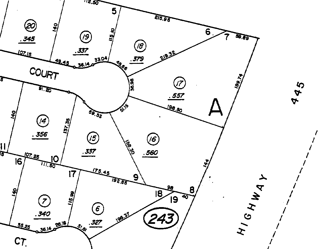
Figure 1. Assessor Parcel Map page
Administrative staff typed the list of APN selections into a simple computer application, which linked the APN to data management software containing related owner names and addresses. The software formatted and printed a series of labels to match the selected APNs. With the generated labels, administrative staff eliminated duplicates or added more APNs to meet noticing requirements.
Pat Rosaschi, Washoe County Development Information Specialist, says, “It was kind of fun,” to discover whether 30 unique owners had been isolated. She enjoyed integrating two department resources (Community Development and Assessor) into a final noticing product and liked setting her own performance goals.
The inspected address labels were manually affixed to a printed card, describing the case application, staff contact names, and meeting date and time. Staff delivered the cards to the mailroom at least 10 days before the hearing date. At this point, the U.S. Postal Service controlled notice card delivery. Both then and now, staff habitually sends a notice card back to the department’s address to verify the delivery timeframes achieved by the post office.
Administrative staff usually completed the manual noticing process within a 2-day window, but was dependent on planning staff to provide case information. Last minute case changes or lagging planners could wrench the noticing process and stress administrative staff to meet the 10-day requirement. Besides, printing and affixing labels by hand can only be accomplished as fast as humans can stick labels on cards. While the tasks often generate spontaneous, good-spirited work teams, the overall expenditure of time and resources was viewed as inefficient.
As many land use planners learn, change is often met with resistance. New software and procedures may convert some staff, but others will be reluctant to change. Preparing for opposition can be important to implementing notice card automation.
Planning staff trained with ArcView 3.0 in January 2000, and began using the software to notice applications soon after. One of our more seasoned planners attempted the first ArcView noticing, using the Select By Theme method. Once the subject site was selected, the planner queried for parcels within a 500-foot distance of the subject site. This initial ArcView encounter created selections, which cut off parcels, would not take in an entire street, and left the planner unable to determine duplicate ownership. Process refinement was clearly needed, along with more experience and understanding of ArcView capabilities.
Next, GIS planning staff and analysts prepared a preset ArcView Project that contained sample parcel Themes and included Layouts with title blocks and scale bars. The planner simply accessed the existing Project, saved it to a new name, and then deleted and added needed Themes. Per department head direction, the preset ArcView Project evolved into a detailed, how-to script.
GIS planning staff and analysts subsequently prepared extensive ArcView instructions of the automated noticing process, so that each planner could make their way through the parcel selection routine. While the instructions are detailed, they do not describe every computer click, with the intention that the planner would enhance his/her ArcView skills by using the software through their own, personal experiences.
The results using the instructions have been mixed. Of the 14 trained planners, less than half became proficient, while others struggled to understand, or did not carefully check computer outcomes. A distinct complaint is that the task is clerical in nature and does not belong as a planner responsibility.
Tight schedules and steep learning curves caused some planners to avoid or deflect the noticing task. Other planners blamed incomplete staff reports on slow, frustrating, or inconvenient ArcView functions. A gap among planners grew, as some rapidly increased their ArcView skills and others did not. More recently, we have observed how certain staff divert map-making tasks to others, which shifts workloads to more ArcView-literate planners.
The implementation of ArcView automated noticing received complete backing and enforcement from Washoe County’s community development director. This support proved essential to overcome the less than enthusiastic support of planning managers, who oversee planning staff. Internal discussions focused on duties staff did not want to perform rather than emphasizing the planning skills built and enhanced by using the software. Eventually, one manager did somewhat convert and has agreed that the ArcView noticing procedure is better than manual noticing.
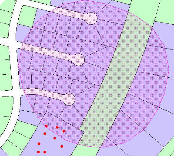
Creating mailing maps and address labels is summarized below, with ArcView screen captures provided for reference. The planner begins by opening a new Project and View, and setting the View properties of map units and distance units to feet. The planner then loads one of 12 planning area parcel base Themes into the View. Once the subject site is located within the parcel Theme, the planner can select adjacent parcels using a Select By Theme distance measure or by creating a buffer Theme in 500-foot intervals (Fig. 2).
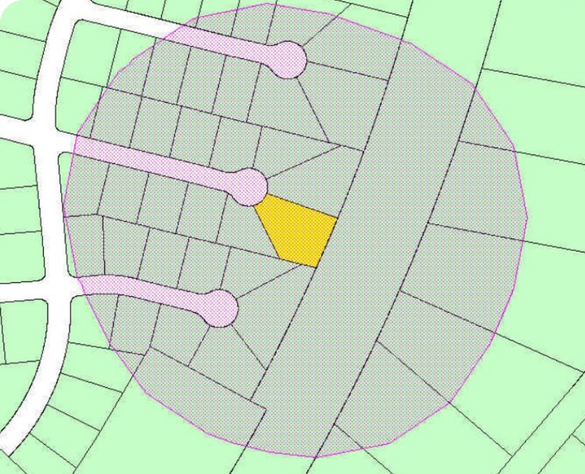
Figure 2. Parcel base Theme with subject site and 500-foot buffer
The parcel base Theme table is joined to a property ownership table, provided by the Assessor’s Office (Fig. 3). The join uses APN as the shared field. The joined tables permit access to owner names and addresses that are exported to notice cards. The join step can occur either before specific parcels are chosen, or after the parcel base is reduced by selections.
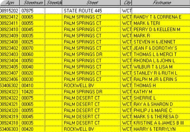
Figure 3. Parcel ownership table
With the the selected set of parcels, the planner may choose to convert the selections to an exclusive Shapefile. This step can assist in managing parcel records, without saving large parcel base Themes for every development case.
The selected parcels table, which is joined to the property ownership table, is exported to a dBase file. Administrative staff converts the dBase file into a Microsoft Excel file in order to combine the owner names and addresses with a Microsoft Word label document. The address labels are merged with the notice card documents for each development case. The documents are then electronically sent to the reprographics division. Once the notice cards are printed, reprographics steps next door to the mailroom for distribution. The automated noticing procedure has significantly reduced clerical staff time and related labor costs, and has freed time for other needed administrative duties.
The planner also creates a map showing the noticed parcels and relevant street names, using a preset ArcView Layout. For record keeping, the planner retains the mailing map in the development case file.
Multiple layer parcels, such as condominium properties, became a serious factor when improper noticing postponed a public hearing. A development case in Incline Village, Nevada, a planned community on Lake Tahoe’s north shore, sat adjacent to a large condominium complex. No one in the condos received a public hearing notice, and citizen tempers flared. The parcel base files prepared for the planners’ use did not address multiple layer parcels.
Consequently, GIS Analyst Gary Zaepfel developed a method for capturing parcel information from upper stories with unique APNs. Upper level properties, such as second and third floor condos, are represented by labels in an ArcInfo point coverage (Fig. 4). Each label feature has an APN and a parent-parcel number attribute. The parent-parcel number field provides the relational link back to the APN on the main parcel database, which only tracks ground level parcels.
In ArcView, a link is established between the APN field of the Theme attribute table (parcel database) and the parent_apn field in the point coverage attribute table. Selecting a parcel that is the ground floor of a multilevel condominium complex will highlight the property records in the point coverage attribute table. Another approach involves adding the point coverage as a new Theme to the active View, and joining the points to the property ownership table. Points within the radius/buffer are selected and the property ownership information exported along with the previously selected parcels.
Figure 4. Condo points overlaid on parcel base
In May 2002, GIS Analyst Moni Fox conducted a non-scientific survey of planning staff, regarding their experience using the ArcView noticing procedure. Considering the past year, the three respondents estimated 30 to 48 separate times they created mailing labels. Two of the three said they were not confident using the method and referred to the detailed instructions in every instance. However, the one planner who is confident using ArcView said the computer selection results were satisfactory 90 percent of the time.
When parcel selection failures occur, respondents say the computer system locks up or ArcView will not respond. In other instances, the link was not properly established between name and address information and the joined property ownership table. Staff cited operator error as an additional reason the selections failed.
The respondents agree they like using the ArcView 3.2a procedures and appreciate having a map product that shows where mailing labels will be sent. Staff also agree they prefer this process to the manual noticing method. Staff describe obtaining the 500-foot buffer as a “cool” feature, and value information access and viewing data in computer map form. The biggest drawbacks to the procedure include the sometimes slow processing speed, the lack of an undo button, and the numerous steps.
When a planner reveals that he/she spends more time creating a mailing list map than writing a development case staff report, serious attention should be paid to improve software use and efficiencies. The desire to improve noticing procedures and support staff needs has generated new automation ideas for noticing.
If process changes can relieve the time investment, staff would have more time to learn and enjoy other ArcView features and benefits. Current ArcView procedures take the planner about 15 minutes to: (1) load parcel base Themes; (2) select parcels; and (3) export data to a dBase file. Under stressful conditions, 15 minutes can feel like an eternity. The planner’s typical hardware setup includes a Pentium Pro machine with 500-megahertz processor, 128 megabytes of RAM, and the Windows 95 operating system.
Introducing new data sets, like digital orthophotography, has also slowed software performance. Washoe County performs computer refreshes to update systems, but like many local governments, the county faces budget constraints. From the department’s financial viewpoint, however, it makes little sense to spend $25 an hour for a planner to sit and watch a computer grind through data. By identifying “power users” and department priorities, strides are being made to upgrade computer systems.
To address software performance concerns, GIS staff discovered speed improvements after developing an ArcSDE extension to ArcView to access a parcel geodatabase. With a parcel geodatabase loaded in ArcSDE and populated with property ownership data, the time invested to create a mailing map was cut in half (about 7 minutes). Using ArcSDE also offers less chance for user error, because it eliminates the table joins required in ArcView and reduces the overall number of process steps.
In Washoe County, land use planners evaluate development cases and spatial relationships using ArcView 3.2a. The simple task of noticing property owners has helped introduce and train planners in the software functions and capabilities. In the coming months, users will be shifting to ArcView 8.3. Once again, planners will be confronted with change and new job expectations. Despite how the changes are accepted or resisted, GIS staff will need to diligently plan for, and help problem-solve, anticipated system, software, and user needs.
Catherine McCarthy, AICP, Senior Planner, Washoe County
1001 East Ninth Street Reno, NV 89520
Phone: (775) 328-3626
Fax: (775) 328-3648
E-mail: cmccarth@mail.co.washoe.nv.us
Moni J. Fox, GIS Analyst I, Washoe County
1001 East Ninth Street Reno, NV 89520
Phone: (775) 328-3615
Fax: (775) 328-3648
E-mail: mfox@mail.co.washoe.nv.us
Gary Zaepfel, GIS Analyst II, Washoe County
1001 East Ninth Street Reno, NV 89520
Phone: (775) 328-3627
Fax: (775) 328-3648
E-mail: gzaepfel@mail.co.washoe.nv.us