|
FUTURE
AGRIBUSINESS MARKET ASSESSMENT [736]
Marcos Leandro Kazmierczak (Business Development) Marcos Covre (Technical Director)
ABSTRACT
With the goal of making one of the largest brazilian agribusinesses more competitive, a project was developed which included the creation of orthophotos covering 150,000 km2, the delimitation of 135,000 production blocks, and the creation of a database. To make this 1.5 Tbyte database available to the field technicians, a process was created to facilitate downloading of a predefined area of orthophotos, blocks, and associated data into an Esri Arc Pad installed on an iPaq Palm Top. A GPS was connected to allow field collection of points, polygons, and routes. A specific data form was designed to provide accurate and updated information for planning and future market assessment.
For the management of an agribusiness undertaking, a detailed knowledge of the area to be managed is necessary. The absence of precise statistics (density, age, stage of production, number of trees) and of trustworthy land-use data constitutes the major planning problem of this sector. It is necessary to know the area currently planted, its’ total area by age strata, its’ phytosanitation conditions, and the manner through which it can be possible to make a reliable production prognosis. The statistics for Brazilian citrus production are as following: it involves approximately 10,000 km2 of crops, 11 industries, 29,000 properties, 400,000 people, and provides 53% of the orange juice and 80% of the juice concentrate consumed in the world. In the citrus industry as in any other, information is a critical resource. A resource which is the specialty of Geographic Intelligence. IMAGEM’s objective is to generate detailed, precise, and current data as far as the number of citrus trees for production planning studies and for future market research. The project involved 4000 field hours, 42000 processing hours, 40 technicians, and 12 processing stations. Two aircrafts were used which generated 10,000 aerial photographs at a scale of 1:30,000.
2. OBJECTIVES The
objective of the project was to inventory the spatial distribution of
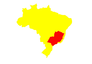
citric-culture (orange, tangerine and lemon) areas located in the states
of Sao Paulo and Minas Gerais, as shown in Figure 1. Areas of commercial
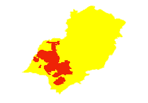
interest, in terms of industrial production, were identified within
these two Brazilian states and are shown in the polygon in Figure 2.
The specific objectives of the project were as follows: Spatial distribution mapping of citrus within the principal production area of the country; Stratification of citrus parcels by age bands; Estimation of number of trees per strata; Maximum margin of error of 5% (five per cent) for the estimates in each age band; and Development of a mobile solution for systematic updating of the database.
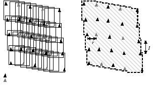
3. FLIGHT PLANNING The planned flight area covered a total area of 150,000 km2, in 326 municipalities. The flights occurred in the period from June to September, with a scale of 1:30,000, using a wide-angle Zeiss RMK Top aerial photo camera, with a focal distance of 152 mm and utilized focal square of 23 x 23 cm. This equipment is equipped with an image-sweeping compensation mechanism, a chassis with suspension and rotation stabilizer, automatic controller for retrieving and gathering, as well as a mechanism for integration with the navigation GPS. Longitudinal retrieval was 60% and lateral retrieval was 30%.
4. SCANNING OF PHOTOGRAPHS The results were converted to digital format from the scanning of slides generated by the flight. For this stage, a Zeiss 3600 Scanner was used, allowing the generation of images with a corresponding ground resolution of .40 m. 5. GPS DATA SURVEY The Control Points for the process of aero-triangulation are a physical component in establishing a mathematical relationship between the photographed images, the camera, and the surface. They are identifiable features located on the ground surface whose X, Y, and Z coordinates are known.
In
order to guarantee that the final project had a precision compatible
with the scale of the flight and to optimize the process of aero-triangulation,
the Control Points had to be distributed in an adequate geometry,
while observing the established minimum distances. For the generation
of this project’s ortho-photos 4,530 control points were identified
that were the aim of the field survey with the Geodesic GPS. The camera parameters and aerial- survey data were introduced. The aero-triangulation defined the parameters associated to the orientation of the camera, establishing the mathematical relationship between the images in the block of photographs, the camera and the ground surface. This determined the real position of the photographs in space at the moment of acquisition. The orthophotos were generated from the wealth of elements of exterior orientation and digital photographs, utilizing a DEM (Digital Elevation Model) with a resolution of 20 meters, for all the area, guaranteeing the homogeneity of the process. Quality control was achieved utilizing the following two parameters: Resolution and Radiometry Quality Standard: examining brightness, contrast, radiometry homogenization between the photos and the blocks of photos; accentuating the citrus trees in relation to the other trees in the background; Geometry Standard: localization and positioning; scale; control of image acquisition; precision compatible with a scale of 1:10,000 in relation to the geometry.
In this way, the positioning precision standards for all of the mapping area generated products conform to the scale of 1:10,000 or 5 (five) meters. The orthorectified images had their histograms equalized and have been made into mosaic blocks from which a single image (comprised of approximately 50 photographs or 750 km2) was created. This mosaic image was radiometrically adjusted for the balance of contrast and normalization of tonality.
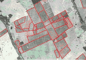
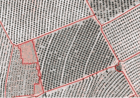
In the previous process the limits of the land parcels were highlighted, facilitating the task of the operator. The identification of land parcel limits were achieved analyzing the image on the screen and visually defining the limits, with the aid of the mouse. The area presented different types of cultures, principally coffee and fruit farms which were not highlighted. Figure 4 shows a concentration of citrus land parcels, in different strata, in one property.
Each one of the land parcels was adjusted to make a perfect closure of the polygon, generating the area and the perimeter and allowing the association of an “identifying unit” (parcel “ID”).
The parcels were classified in four strata, as a function of spectral variability of the stage, conforming to Table 1. Table 1. Strata used in mapping.
The four age strata were defined as functions of the spectral variability of the stages, relative to the degree of density of the plants, and that indirectly corresponds to an age strata (newer parcels show sparse trees; older parcels show trees that intersect). Beyond this, it is important to emphasize that this variability, along with the degree of density of the plants, can vary from photo to photo, depending on spacing, tract cultures, atmospheric conditions, time of acquisition (illumination) of the photo and solar effects.
The classification could then be carried out in sequence, in a manner which allowed the extracted information to have the greatest precision and best quality. The objective of classification standards is to be able to assign a pixel to one of various possible classes of interest, this being a basic tool of statistical decisions. The classification was based on two general principles: Every image component can be characterized in conjunction with its correlates in distinct regions of the spectrum (also called “spectral signature”). Objects of the same class have similar spectral signatures, this does not occur between different classes.
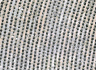
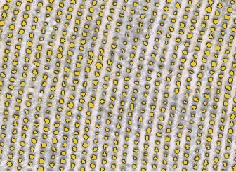
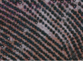
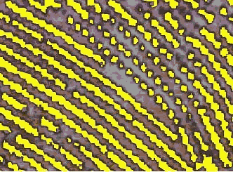
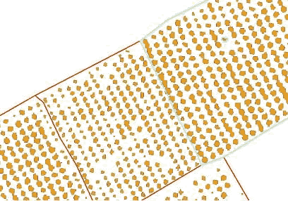
In carrying out the classification of images, seeking to identify each of the trees, two distinct situations were faced. The first is in respect to those areas with Type 1 parcels, in which the trees were perfectly identifiable, the planting was homogenous, the culture tracts were applied and the substrata barely appeared. Figure 5 clearly shows that the orthophoto (on top) allows a high performance classification, visualizing the result of the classification (center) and the result of data vectoring (below). In this situation, the counting was carried out in a totally automated (number of polygons) fashion by the system. Looking at Figure 6, with a Type 2 parcel, it is evident that the parcel conditions substantially impaired the classification. Difficulties were caused by the absence of culture tracts, problems in the area of phyto-sanitation, age or spacing (high density of plants). In many situations the trees were found to be interlinked and crossing making it impossible to individually distinguish them.
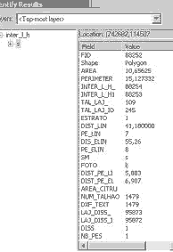
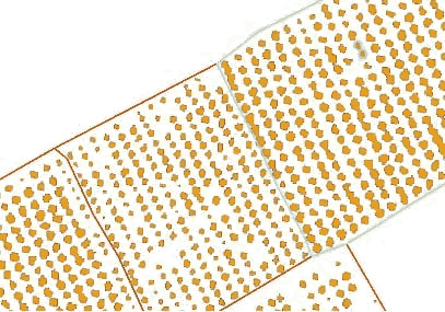
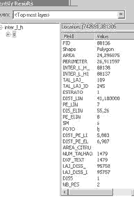
To confront this problem, IMAGEM developed an algorithm, based on the ALM language of Arc Info, which verified the attributes of previously classified units and, based on this analysis, computed the number of trees that each polygon represented, as in Figure 7 and 8. The algorithm accounted for all the trees included in the parcel in question, providing the final count as an attribute of the parcel. In the example in Figure 7, there is a polygon selected (ID 88252) in a parcel (ID 245), representing 1 tree (attribute NB_PES = 1). In the example in Figure 8, there is a polygon selected (ID 88136) in a parcel (ID 245), representing 2 trees (attribute NB_PES = 2).
Containing a total of 10 thousand orthophotos and 135 thousand parcels of citrus land, the volume of the data attained a total of 1,5 TBytes. To optimize both task time and the manipulation of images, Mr. SID was used to compact the images with the smallest radiometric loss possible. The final volume of the data was 200 GBytes.
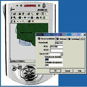
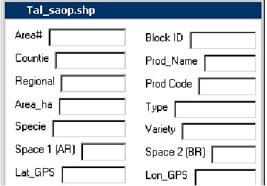
In order for the field technicians to be able to arrange the information to optimize the task of updating and for the insertion of attributes that were not within the scope of the project, a mobile solution was developed that utilized a Palm Top, GIS and GPS. The development of the mobile solution was achieved by adopting of a COMPAQ iPAQ, Esri Arc Pad, and a Trimble Pocket GPS. It included a total of 100 pieces of equipment, and the customization of formulas for the collection and systematic updating of data. This solution allowed the download of a predetermined area of interest, so that the orthophotos and the land parcels with their respective attributes could be carried in an Arc Pad. The connection with a GPS receptor allowed the insertion of new graphic elements, facilitating the identification of new areas or the exclusion of eradicated areas.
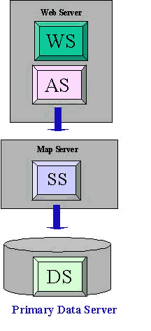
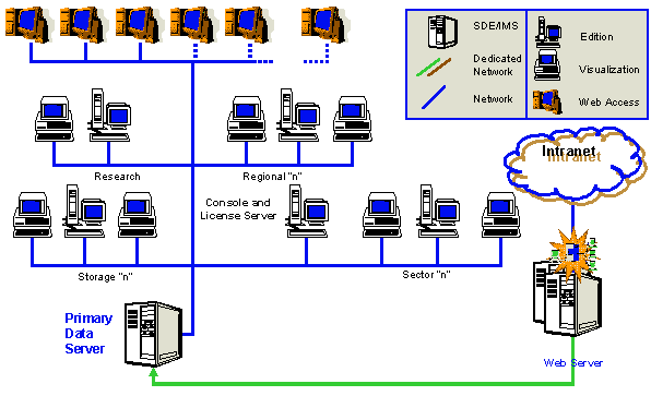
From the database consultations and spatial analyses can be run which can furnish allowances for the definition of better alternatives of action with the aim of [1] promoting the improvement of the performance of the diverse activities of planning, field information surveys and updating of database attributes, [2] guaranteeing a greater agility in the previously mentioned activities and [3] minimizing costs. The best way to achieve these goals is with an interface (Windows environment) through which the user makes a request (consultation) from the database. The connection is achieved using the ARC IMS, which processes the request and creates in the browser a table or a “jpg” with the map/result of the consultation. The average processing time is from 2 to 10 seconds, depending on the link between the user’s computer and the data server. The architecture of the proposed system should provide high availability and scalability with the capacity to serve up to 100 users. As illustrated in Figure 12, shown in sequence, all the system of user-requests was designed for high availability. WS/AS stands for the Web Server, responsible for the HTTP protocol communication and the Application Server (dynamic web site) to be implemented, responsible for the functions of user consultations. Arc IMS components are installed in this server which communicate with the SS. WS/AS can be allocated in the same server hardware and can be run by the structure already available in the business through their Intranet. SS stands for the Spatial Server, or map server, responsible for rendering the maps generated by the user requests. The Map Server is an intense processing machine and it is recommended that it be a machine with an Intel processor of 1 Ghz with 1024 Mb of RAM memory. The Arc IMS components are installed in this server for the generation of maps and access to the DS. The Web Server/Application Server and the Data Server could be machines already available. DS stands for the Data Server, where the Arc SDE and Informix licenses are installed, and that are used as repositories for geographic data. The corporate database server of the business may be used, however recommendations exist for configuring the DBMS in relation to the size of the data (data block) specific to the management of geographic data, beyond the recommendations for the coexistence of Arc SDE and DBMS.
The system can service a greater demand than that originally anticipated (50 users) as is necessary, with the addition of another Map Server (SS). The subsystem architecture for updating the geographic images involves the receiving of updated data and the same task in the repository of geographic data. This operation would be executed using the Arc GIS (Arc Map) software.
The following aspects may be cited as resulting benefits: Mapping of the citrus area: it was possible to identify the citrus areas and analyze the spatial distribution at the forefront of the existing infrastructure of this industry, in an area representing 83% of the production area of the country; Stratification and quantification of the planted area: the availability of the numbers of land parcels (in hectares) in each of the defined strata provided fundamental assistance for the planning studies of the sector; Estimates of the number of trees for the age strata: with the number of plants in each of the defined strata, detailed studies can be carried out on the number of trees that are not yet in a state of production, on the number of trees in full production and on the number of those trees which will soon be eradicated to make room for new plants or cultures; Assistance for regional productivity studies: Studies may be carried out on the prognosis and tendencies in production specific to each region of interest; Estimate error: the estimate error, when compared with real data from land parcels previously sampled, was 2.5%.
|
|||||||||||||||||||||||||||||||||||||||||||||||||||||
