Title
A Consultant’s Role in NPDES Stormwater Data Collection and Management for Municipalities
Abstract
Greenman-Pedersen, Inc. (GPI) has played an active role in supporting municipalities in the State of Maryland in achieving compliance of their stormwater National Pollutant Discharge Elimination System (NPDES) permits for Municipal Separate Storm Sewer Systems (MS4). A major portion of the support involves collecting and inventorying stormwater features, such as storm drain (SD) systems and stormwater Best Management Practices (BMPs). More recently the support is extending to the transfer and management of the data to the municipal clients, whose needs vary from NPDES compliance to managing their drainage assets. The purpose of this paper is to outline the changing role of the consultant in both data collection and data management of the GIS that stores the data associated with NPDES. Several Esri packages have been central to this process including: ArcPAD, ArcGIS, ArcView 3.2a and MapObjects LT. The role and benefit of each of these software packages relating to this project will be discussed.
Introduction
With the advent of the stormwater NPDES program for Phase I and more recently Phase II communities, managing drainage information has become crucial both for permitting compliance as well as sound infrastructure management. The initial phases of a NPDES program, known as Part 1, involves collecting and organizing the existing drainage data. In addition, data collection may also involve assessments of the drainage features, such as outfall screening, BMP inspections, surface water chemical analyses, etc. In addition, municipalities need to contend with ever expanding and aging infrastructure. Municipalities may need assistance to locate and manage their drainage infrastructure in a timely fashion, and consultants can provide support by developing collection applications that incorporate the power and flexibility of GIS to meet these needs. The next level of a NPDES MS4 permit is the development of a stormwater management plan, known as Part 2, which in general requires municipalities to show how water quality is maintained and where necessary improved. GIS will play a key role in developing, managing, and analyzing the overwhelming amount of NPDES stormwater data; and many municipalities may rely on consultants to achieve the benefits provided by GIS in a cost-effective manner.
Background
The NPDES program is an “unfunded mandate” stemming from amendments to the Clean Water Act, forcing municipalities to cope both with managing drainage infrastructure to ensure public safety as well as meeting permit compliance by using existing staff and resources, such as consultants. Some of the major categories of a NPDES MS4 permit are generalized below:
Source Identification - provides the basis for subsequent tasks and involves identifying stormwater features. At a minimum involves identifying SD outfalls, but may include delineating the SD network and structures that capture and route stormwater as well as BMPs. The source identification can include: collecting infrastructure location, identification, and characteristics; drainage area/land use; ownership; condition assessment; connections to local systems, receiving water body characteristics, etc.
Discharge Characterization - in general determines the location and magnitude of water quality problems with the results being used to assist in developing management programs and predicting their success.
Management Programs – involves developing programs that control the quality of stormwater runoff to the fullest extent possible. This includes many different approaches, such as detecting and controlling illicit connections; developing outreach and education programs; implementing an inspection/maintenance program for stormwater features, etc.
Purpose
Municipalities that must comply with an MS4 permit will need to be resourceful to address the requirements. Portions of the permit may already be accounted for through a variety of existing efforts, such as Capital Improvement Programs (CIP), roadway maintenance operations, watershed/drainage studies, Public Awareness Programs, etc. Municipalities are typically staffed with managers and engineers, and some may have staff dedicated to complying with NPDES regulations. However, many municipalities rely on outside resources, such as engineering consultants to support these activities and meet regulatory schedules when their MS4 permits are issued. Consultants provide an immediate technical resource as well as a management component since many may be working with several divisions of a municipality.
A consultant or a team of firms can support a municipality at various stages or technical levels. In some instances, such as municipalities that outsource engineering services or communities thrust into Phase II compliance, total reliance on consultants may be necessary to achieve compliance. Once a consultant(s) is involved, they uniquely share a portion of the responsibility of understanding and meeting the MS4 requirements as well as the other needs of the municipality. For example, relevant issues that may require consideration to bringing on-board consultants are:
- What is municipality’s permit status?
- Does their MS4 permit state the required drainage information?
- Is the level of detail for drainage information defined and a timetable provided?
- What internal resources, from maps to GIS staff, can a municipality can utilize?
- What are the users of the NPDES data and their needs?
- Can future review, editing, and reporting of data be anticipated?
A consultant may be involved peripherally or entirely, but they can provide support by the use of GIS applications that can range from “off-the-shelf” to custom interfaces
. The two phases a consultant may lend support follow the progression of a MS4 program, the first is the GIS Development to inventory stormwater features and the other is the GIS Application to manage the stormwater features.
Development of Stormwater Features GIS
To comply with NPDES goals and to effectively manage infrastructure, municipalities need to recover, inventory, and where possible inspect their SD systems and BMPs. This can be performed in several approaches, but in general comprises of office processing, field investigation, and GIS integration.
Office Processing
This involves locating and processing data, such as as-built plans, utility maps, aerial photography, drainage maps, etc. This is a lengthy process and requires diligence in uncovering the most recent data about the existing stormwater features. Data scrubbing includes identifying, characterizing, and labeling SDs and BMPs. Feature locations can be digitized directly in GIS or by CAD then imported into GIS, and attribute data is entered into databases. The data quality can vary, and mapping problems arise such as correctly assigning coordinates to register the plans. This task is typical of past consultant’s role.
Field Investigation
Usually a field investigation is required to verify SD and BMP locations plus attributes. When features were not located correctly or constructed, or additional structures were recovered, adjustments of the GIS model are required. The recent development of GIS, GPS, and field computer systems to digitally collect and edit this information greatly enhances the accuracy and expediting the updating of stormwater GIS model. Numerous tools are available to assist in the field investigation. These tools provide mobile computing that is a fundamental change since GIS is being brought out into the field. These are new tools that consultants are constantly evaluating and deploying in the field.
A useful and powerful field tool is Esri’s ArcPAD application on a field PC, which allows the use of GIS data developed in the office to be integrated with the GPS data collected in the field. Exhibit 1 shows a sample screen display. To make data collection easier and more efficient, standard data entries can be set by using pull down menus, numeric keypads, etc. This is a cost effective approach to editing and collecting stormwater data, especially small-scale projects that require immediate deployment.
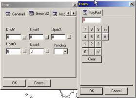 Exhibit 1 - Example of ArcPAD interface on a Field PC
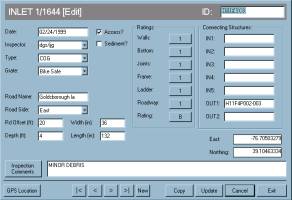 Exhibit 2 - Example of a VB Database Interface on a Field PC
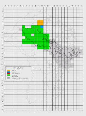 Exhibit 3 - Example of Daily Field Progress in ArcVIEW
Following the completion of the office and fieldwork, the compilation of the digital data is necessary. The geo-reference data associated with SD and BMP and base mapping are integrated into a GIS model, such as ArcVIEW. The base mapping usually includes roads, hydrology, and other relevant features such as watershed delineations, land uses, etc. The stormwater features, however, can be in different GIS formats. For example, a SD system is made of different structural components that can be displayed as points and/or arcs in GIS. Examples of point Structures are inlets, manholes, field connections, and outfalls. Examples of Linear Structures are pipes and ditches. Typically Point Structures are each given a unique ID that may be based on its location or sequential scheme. The Linear Structures can follow the same format but may further be defined by a combination of their upstream and downstream point structures. The objective of labeling schemes is to provide intelligence in the name and allow for future recovery of the system in the field based. These are issues typically pre-defined, but consultants can provide invaluable advice on appropriate naming schemas. Exhibit 4 shows an example of storm drain data in ArcVIEW. Either Points or Polygons, however, can describe a BMP feature. Exhibit 5 shows an example of BMP data displayed in ArcGIS.
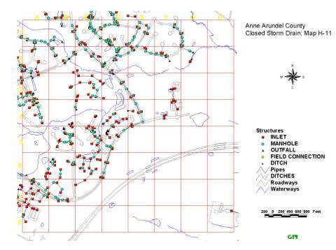 Exhibit 4 - Example of Storm Drain Mapping in GIS
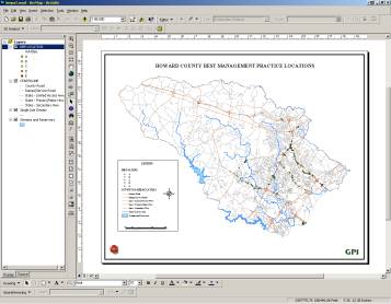 Exhibit 5 - Example of BMP coverages in ArcGIS
Ultimately when the data is compiled into a GIS model, municipalities will need to manage the data. Various needs to apply the GIS data may derive directly from NPDES requirements, in support of a stormwater asset management, data requests from other division, or other needs. For example, municipalities may need to export/import, view, query, and document stormwater data. For NPDES compliance, permit conditions require municipalities to prepare Annual Reports. The report covers each of the permit requirements and progress to-date must be described. In many cases, the development and use of GIS in NPDES related tasks must be demonstrated. For example ArcVIEW can be used to show annual field results. Exhibit 6 demonstrates the compilation of outfall screening and BMP inspections overlain on GIS mapping. Exhibit 7 demonstrates the compilation of SD systems and recent aerial photograph overlain on GIS mapping. These are excellent examples of how Esri’s products are to manage GIS data and provide the necessary mapping capabilities within cost-effective approach.
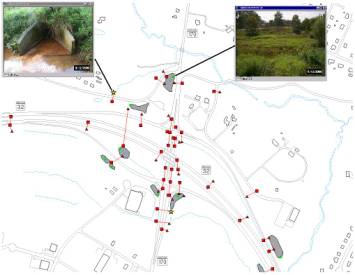 Exhibit 6 - Example of field data show in ArcVIEW
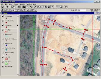 Exhibit 7 - Example of SD ArcView Shapefiles and Aerial Photography
For example, a VB application can provide a custom interface to interact in an understandable and straightforward format for stormwater data stored in database tables, GIS coverages, and various media files. This is critical because users must be able to first quickly identify features then view the associated inventory and inspection data for individual or group. An VB interface streamlines access via easy to use database and spatial query tools, and provides a auto-visual display of the feature location. These tools allow users to select the data they want without having to create cumbersome query strings or use complicated spatial tools. Exhibit 8 is an example of a custom application to mange BMP data.
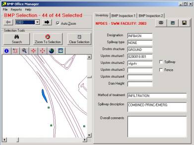 Figure 8 - Sample Screen of a Management Application using MapObjects LT
Other data needs are standard reporting where a standard data format is utilized. These can be developed to specific user needs, such as developing, work orders, cost tracking, or progress summaries for Annual Reports. Exhibit 9 is an example of a standard report developed from a custom application that shows GIS mapping, attribute summary, and digital site photos. Consultants who specialize in NPDES may also be experts in SD and BMP design/assessment, which can provide a municipality with turn-key expertise.
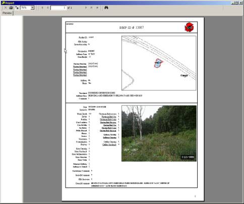 Figure9 - Sample Report from a custom Data Management Application
Ackowledgements
The authors would like to acknowledge the Highway Hydraulics Division (HHD) of Maryland State Highway Administration and the Infrastructure Management Division (IMD) of Anne Arundel County, Maryland for their contribution of material to support this paper. Specifically we would like to recognize the efforts of Mr. Raja Veeramachaneni and Ms. Sonal Sanghavi of HHD, and Mr. Darryl Hockstra and Mr. Andy Watcher of IMD.
Author Information
Peter Mattejat, PE, Water Resources Director, Greenman-Pedersen, Inc. (GPI), Jessup, MD (301) 470-2772, p_mattejat@gpinet.com
Eric Wilson, GIS Analyst, GPI. Jessup, MD, e_wilson@gpinet.com
Mark Day, Application Development Director, GPI. Babylon, NY, m_day@gpinet.com


