1.Introduction
2.Survey outline
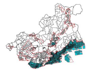
2.1.Reference limits of the survey
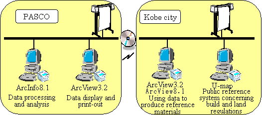
2.2.System structure
2.3.GIS Data
| Elements | Information level of map | Method of preparation |
| Topographical map(1/2500DM) | 2500 | Renewed by aerial photo survey |
| Regulatory system information | 2500 | Regulatory system zones entered as polygon data |
| Road polygon | 2500 | Roads extracted from topographical maps (1/2500DM) are converted into polygon data and divided by a representative width |
| Central road line | 2500 | Central road lines entered as line data |
| Building lot polygon | 2500 | Land use maps entered as polygon data |
| Block polygon | 10000 | Block area converted into Polygon data |
| Division polygon | 10000 | District polygon integrated into Town level |
3.Result of survey
3.1.Total Unit
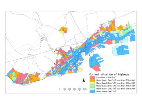
3.2.Current situation of highways
-
1) The total of road lengths over 12m in width
The central line data of the roads' length measurements and width were totaled for each town.
2) Calculation of road density for roads over 12m in width.
The road lengths for roads over 12m in width were calculated for each town by removing the polygon measurement areas.
3) Conditions of road line density
Table 2 below, shows the road line density for roads of over 12m in width and its results are shown in diagram 3.
Table 2. Classification of density of roads over 12m in width
| Method of classification | Color classification |
| Less than 1.5sq km | Red |
| More than 1.5sq km,less than 2.5sq km | Orange |
| More than 2.5sq km,less than 3.5sq km | Yellow |
| More than 3.5sq km,less than 4.0sq km | Green |
| More than 4.0sq km,less than 6.0sq km | Light blue |
| More than 6.0sq km | Red |
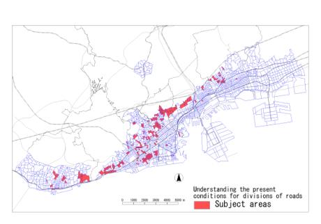
3.3.Understanding the present conditions for district of roads
-
1) Total road length
Central line data of the roads' length measurements were calculated for each division.
2) Total of road length for roads of width less than 4m
The length measurements and width of the central line data of the roads were calculated for each division.
3) Total building lot area
The area measurements for the building lot sector polygons were calculated for each division.
4) Calculation of road density
By removing the road length data from the building lots sector area, the number of roads of width less than 4m was calculated for each town.
5) Calculation of road density of roads of width less than 4m
Total road length of width less than 4m was divided by the total road length of the area to calculate a road rate for each area.
6) Extraction of the targeted district
From the above calculations, the targeted district was extracted and its results shown in diagram 4.
4.Conclusion
The results of this survey show:
1) GIS data was unified at about the 2500 level.
2) Various basic information was maintained as GIS data and saved.
3) Arc Info8.1 overlay function was analyzed leading to a rapid survey.
Acknowledgements
Supplementary notes
Kazuhisa Matsunaga
PASCO CORPORATION