The avalanche release area is an important parameter to be estimated for the avalanche hazard mapping procedure. While parameters like run-out distance or deposition height are usually easy to measure, the release area is often difficult to determine, due to terrain inaccessibility and/or bad weather conditions in the upper areas of an avalanche track.
In this work a detailed analysis of mountain topographies is performed to find general rules for the assessment of potential avalanche release areas. Using Geographic Information System (GIS) technologies in combination with Digital Elevation Models (DEM), historic avalanche release area records have been analysed with respect to topographic characteristics. This study is performed in the region of Davos (Switzerland), where an almost complete database of avalanche events over the last 50 years exists. Firstly, large scale topographic parameters are derived from the DEM in order to automatically define potential release areas. Secondly, every potential release area is characterised by smaller scale geomorphologic parameters. Finally, these geomorphologic parameters are analysed with respect to the avalanche frequencies observed in the different potential release areas. First results clearly demonstrate the correlation between the derived geomorphologic parameters and the avalanche occurrence frequency.
The definition of a potential avalanche release area is crucial for an avalanche expert who has to estimate the avalanche hazard for a certain site, since it determines - together with the fracture depth - the initial volume of an avalanche. This volume is an important parameter for the development of an avalanche on its way down to the valley bottom: A large initial volume allows a large avalanche to develop, with a long run out distance even if the snow conditions along the avalanche track are not favourable; small initial avalanche volumes usually lead to smaller run out distances unless the conditions along the path are very favourable. In addition, the topographic characteristics of an avalanche release area is one of the most significant parameters determining the frequency of the avalanche. A good knowledge of the avalanche frequency is crucial for the avalanche hazard mapping procedure (BFF/SLF 1984). Avalanche hazard maps in Switzerland are worked out by a combination of an analysis of historic events and avalanche calculations (Gruber 2001, Salm and others 1990). Historic avalanche events give an idea of the size and type of avalanche that may occur in the future. However, there is often not enough information available for a particular site to derive a valid statistic of the frequency of avalanches of a specific size. This approach aims to overcome this lack of information by performing a detailed statistical analysis over a large area, where a very good database of recorded avalanche boundaries is available. The concept is to relate patterns of avalanche occurrences to geomorphologic parameters so that the statistics can be transfer from this well recorded site onto less known areas using only the geomorphologic characterisation.
The method was developed using the historic avalanche occurrence recordings of the region of Davos (Switzerland). In this area an almost complete digitised database of about 4500 avalanche events over the last 50 years is available extending over about 300 km2. The historic avalanches are stored either as arcs or polygons with various attributes about the avalanche type and occurrence time.
The method is composed of two steps:
The goal of the first step is to identify all potential release areas and to split them into smaller coherent units that can be considered as standard potential release area (PRA) of one single avalanche event. This step is necessary because an objective and reproducible basis is needed to derive relatively homogeneous areas, that can be characterised within the second step. In the second step, small scale geomorphologic parameters were derived from the DTM to describe each PRA and to relate these characteristics to the avalanche frequencies of every PRA. Both steps are based on automatic AML-procedures so that they can be easily transferred to other areas. The DHM25 of the Swiss Federal Office of Topography (Swisstopo 2002) is used as DEM. This also enables the transfer to other areas in Switzerland, since this DEM is available for the whole Switzerland. In the following sections, the two steps are described in more detail.
In general, avalanches can initiate on any slopes with an inclination between 30° and 60° except if dense forest is available to prevent avalanche initiation (Salm, 1982). In theory it is possible, that all these slopes will release at the same time, but usually, avalanches occur on smaller portions that (a) are distinguished from each other by topographic features such as ridges for example and (b) show a certain topographic homogeneity within its area. Yet, a general definition of the criteria that separate neighbouring release areas from each other is not available. The goal of this step is to propose such a definition for a standard potential release area - remaining aware, that this definition might fail in some extreme cases. But for the purpose of this approach such a definition is essential to be able to automatically delineate potential release areas and to have an objective basis to make the statistical analysis of the topographic parameters between the various PRA in the second step.
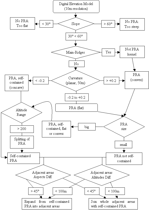
In Figure 1 an overview of the procedure for defining the PRA is shown in a flow-chart. Because avalanches can not start within densely forested areas, such areas were excluded from the analysis. As mentioned above, the most important topographic parameter is the slope angle. Below 30° the gravitational force is too weak to initiate an avalanche, whereas on slopes steeper than 60° avalanches are very frequent but of small dimensions, because no big snow deposition is possible on such steep slopes (Munter 1997).
Figure 1: Procedure for the automatic definition of the PRA.
The second criterion is the exclusion of main ridges from PRA and using them also as a separation feature for the PRA. The main ridges are automatically derived from the DEM using a procedure which is the combination of the two methods explained briefly in the following and in more detail in Bertogg, 2001:
The intersection of these two regions delineates the main ridges.
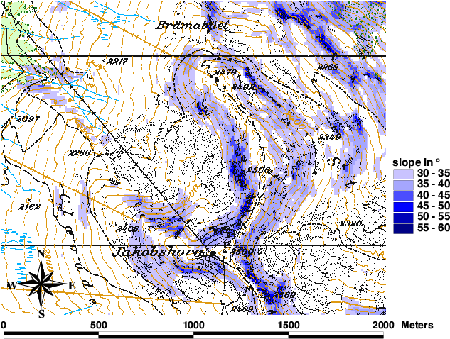
Figure 2: First selection of a potential avalanche release area based on slope-angle. (Digital Map Data PM25: © Swiss Federal Office of Topography, JD022302).
The resulting area has to be divided into smaller ones that are comparable to the observed release perimeters. The first idea was to identify them using the watershed procedure (ArcDoc 2001). The problem with this approach was the definition of a lower boundary for the flow accumulation procedure. Several approaches with different definitions of this lower boundary failed, since often very thin watersheds were delineated or alternatively one watershed turned out to be too dominant. In Figure 3 the result of such an approach is shown using a slope angle of 15° as a lower boundary.
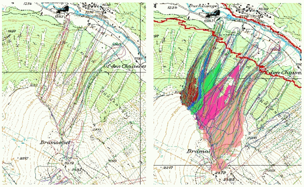
Figure 3: Left: Brämabüel area in the region of Davos (CH) with observed avalanche events. Right: Release areas defined using the watershed approach. The red line indicate the lower boundary. Although the two pink ones on the right (SE) side seem to be well-defined, the others are not good, especially the blue one. (Digital Map Data PM25: © Swiss Federal Office of Topography, JD022302).
This approach was abandoned in favour of another one that is related to the curvature of the terrain. The GRID command 'curvature' computes the curvature of the slope separated into two orthogonal components where the effects of gravitational processes are either maximized (profile curvature) or minimized (plan curvature) (ArcDoc 2001). For the definition of the PRA the plan curvature is used to separate concave areas from flat and convex ones (Figure 4, Figure 1). Note that the spatial resolution of the DEM has been reduced to 50 m so that only the large scale curvatures are considered, since the smaller scale topographic curvature changes are not capable of separating neighbouring release areas from each other.
Areas with a value of plan-curvature lower than -0.2 are considered concave PRA. Independent of size they are considered self-contained, i.e. they are classified as the kernel of one single potential release area. If the value of curvature is higher than -0.2, the size of the areas is taken as the criterion for determining wether the flat and convex PRA are big enough to be considered as self-contained. Small areas are classified as expansion areas in which the self-contained PRA can be expanded.
In the next step a self-contained PRA is split if its altitude range is more than 200 m. This differentiation is necessary since on steep and long slopes, where the critical slope angle never falls below 30° except for near the run out zone, the whole area would be assigned as one single PRA. This is not reasonable, since important criteria for the determination of avalanche frequency may vary along this distance, leading to a very inhomogeneous characterisation of the PRA. The value of 200 m was arbitrarily introduced by visual comparison of the results to the observed avalanche events.
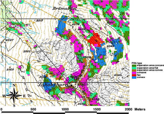
Figure 4: Curvature: pink shows concave, blue convex and red flat PRA self-contained. The other colours identify expansion areas. (Digital Map Data PM25: © Swiss Federal Office of Topography, JD022302).
Two additional criteria are used to arrive at the final result. Adjacent areas are merged if the altitude difference is less than 100 m and the mean aspect difference is less than 45°. In the remaining expansion areas the self-contained PRA can linearly expand. The comparison of Figure 4 and Figure 5 demonstrates the effect of the expansion of the self-contained PRA into the expansion areas; the blue line in Figure 5 outlines the boundary of the potential release areas resulting from this procedure.
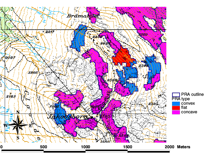
Figure 5: The PRA resulting from the automatic procedure. (Digital Map Data PM25: © Swiss Federal Office of Topography, JD022302).
The following parameters are considered to represent the characteristics of every PRA:
During the first step of the definition of the PRA, some expansion procedures were applied in order to assign the maximum extent of a potential release area. However, for the topographic characterisation of the PRA it is better to identify only the most representative area of the PRA and to neglect the boundaries that may differ significantly from the core area and therefore can influence the mean aspect or the curvature in a way that is not wanted. We decided to identify the centroid of every PRA and consider the ellipse defined by the geometrical parameters given by the CENTROID function in GRID (ArcDoc, 2001) as a good representation of the PRA. In Figure 6 the ellipses for the area in Brämabüel are shown. The intersection between every PRA and the related ellipses gives the area in which the analysis is performed .
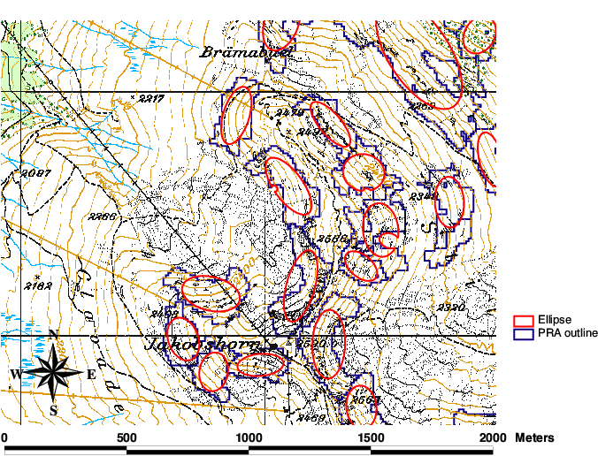
Figure 6: Ellipses related to the potential release areas used to identify the core for the characterisation. (Digital Map Data PM25: © Swiss Federal Office of Topography, JD022302).
In the following we illustrate first results of the topographic terrain characterisation for three PRA in the test area (Figure 7) and its relation to the avalanche frequency. At the first glance it is evident that the first two potential release areas (PRA1, PRA2) are quite similar but PRA3 differs, mainly due to curvature. What we expect is that the first two PRA have similar avalanche activities, which differ significantly from the third one.
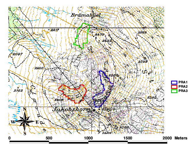
Figure 7: The three test potential release areas and past avalanche events. (Digital Map Data PM25: © Swiss Federal Office of Topography, JD022302).
Table 1 shows the values of the characterising topographic parameters for the three considered PRA. Analysing the past avalanche activity, we can say that in PRA1 and PRA2 respectively 35 and 34 avalanches occurred, while in PRA3 only 15.
| Mean slope | Min slope | Max slope | Mean aspect | Curvature | Distance to ridges | Number of avalanches | PRA1 | 38.6° | 30° | 49° | 302° (WNW) | concave | 0 m | 35 | PRA2 | 36° | 30° | 47° | 346° (NNW) | concave | 0 m | 34 | PRA3 | 34° | 30° | 40° | 276° (W) | convex | 30 m | 15 |
|---|
Although this procedure is only a first rough method which has to be refined, we had encouraging results. In fact its application to the three test PRA in Davos gives results confirming what we hoped to demonstrate: Avalanche sites with similar / different characteristics in the release area have similar / different avalanche activities.
In future this procedure will be applied to the entire region of Davos where avalanche data are available to enlarge the statistical basis. The goal is to obtain a catalogue of potential release areas characterised by many different combinations of topographical features.
This analysis of avalanche release areas is performed in an automatic way with a view to having a general and objective tool which could be helpful in delineating the possible release area for a specific avalanche site. The method proposed here requires validation. It's necessary to check for example the number of avalanches that occur within the defined potential release areas with the ones that are outside. Until now, no systematic validation has been carried out, but it can be said that a good percentage of historical avalanches fall within the boundaries of our defined PRA. There are also cases of avalanches that started at the same time from different adjacent release areas. Therefore we have to develop a procedure to deal with this possibility, that two neighbouring PRA can release simultaneously.
Another problem is how to define curvature, which is a scale-dependent parameter. A precise value of curvature has not been computed with GIS during the characterisation of the PRA, but only a rough classification into the classes convex, flat or concave. The method for the characterisation of the PRA needs therefore further refinement, considering additional parameters such as the size of the PRA.
Nevertheless of these deficiencies, the approach provides already some important help for the procedure of avalanche hazard mapping. The method is providing an objective tool for the definition of the avalanche release area extent. This helps to identify similar terrain constellation over a large area and to use their related historic avalanche data to asses the avalanche frequency in a less known site.
This work focuses on the release area, which is one of two important parameters related to the starting zone of an avalanche. It is a part of a more complex work to take into account also the fracture depth and the analysis of the meteorological and snow data.
ArcDoc, 2001: ArcInfo Online Help. ArcDoc Version 8.1 Service Pack 1. Copyright (C) 1982-2001 Environmental Systems Research Institute, Inc.
Bertogg, R. 2001. Analyse der Topographie von Lawinen-anrissgebieten im Lawinenwinter 1999. Diplomarbeit - Universität Salzburg.
BFF/SLF, 1984: Richtlinien zur Berücksichtigung der Lawinengefahr bei raumwirksamen Tätigkeiten. Bundesamt für Forstwesen (BFF) und Eidg. Inst. für Schnee- und Lawinenforschung (SLF). Eidg. Drucksachen- und Materialzentrale (EDMZ), Bern.
Gruber, U., 2001: Using GIS for Avalanche Hazard Mapping in Switzerland. Proceedings of the 2001 Esri International User Conference July 9-13, 2001, San Diego. http://www.Esri.com/library/userconf/proc01/professional/papers/pap964/p964.htm
Munter, W., 1999: 3x3 Lawinen: Entscheiden in kritischen Situationen. Agentur Pohl & Schellhamer, Garmisch-Partenkirchen. ISBN 3-00-002060-8.
Salm, B. 1982. Lawinenkunde für den Praktiker. Verlag Schweizer Alpen-Club, Bern.
Salm, B. Burkard, A. und Gubler, H.U., 1990: Berechnung von Fliesslawinen. Eine Anleitung für den Praktiker mit Beispielen. Mitteilungen des Eidg. Inst. für Schnee- und Lawinenforschung, Nr. 47, Davos.
Swisstopo, 2001: Swiss Federal Office of Topography. Product Information. http://www.swisstopo.ch .