DEVELOPMENT OF THE GEO-REFERENCED INFORMATION SYSTEM – SIGER AS THE CORE OF INGEOMINAS’ GEO-SCIENCE INFORMATION SYSTEM (SINGEO)
Héctor Hernando Torres Rojas*
Xavier Bohigas**
*Instituto de Investigación e Información Geocientífica, Minero-Ambiental y Nuclear
(Geo-Scientific, Mining, Environmental and Nuclear Research and Information Institute)
** ROCHE International
Keywords: National, Geoscience, Information, System
Abstract: National Geoscience Information System. INGEOMINAS (Instituto de Investigación e Información Geocientífica, Minero-Ambiental y Nuclear) is a public institution attached to the Ministry of Mines and Energy of Colombia, operating basically as a full geological and physical environment survey and as the mining sector research and development institute. It is the entity in charge of providing nationwide information on earth sciences and related technologies. The purpose of the SINGEO – Ingeominas’ Geoscience Information System is to provide the users with the necessary tools to support the compilation and integration of geoscience data (spatial and descriptive) and the generation of official products as defined by the organization in response to clients'needs.
INTRODUCTION
The institutional mission of INGEOMINAS is to provide information for a better understanding of the Earth, its evolution, composition, dynamics, resources, and geologic and anthropic threats through scientific research and multidisciplinary and inter-institutional work. Complying with this mission involves the constant generation of large volumes of geo-scientific data that must be organized, processed and transformed in useful available, and easy to understand information for the community. The purpose is not to duplicate existing data but to develop alliances among individuals and organizations that may be either suppliers or users or this information for the benefit of all of them. In the foreseeable future, someone will want information on a specific subject and, if that information is available, regardless of who has it or where in the world it is located, the user having found the required data, can download them from the Internet by using the facilities of the SINGEO, that INGEOMINAS, will develop through specific projects (Fig. 1).
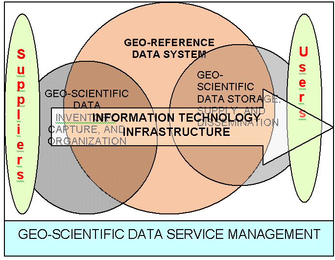
Figure 1: Institutional Projects to develop SINGEO
OBJECTIVES
- To provide access to data, information, and geo-science products
- To provide value-added to geo-science data in INGEOMINAS.
- To allow the conversion and integration at short term of existing data bases into the system.
- To allow field survey data to be captured in the system within a four-week term after field work is completed
- To support administrative principles on data accountability (only one area accountable for each type of data) and data availability (guaranteed access to the different kinds of data).
- To furnish geo-scientific data in standard format to support the generation of official products of the institution.
- To support standardized product generation (i.e., conventions, map formats, etc.)
- To allow the generation of products in hard copy or digital format.
- To supply basic geo-scientific data in standardized format to facilitate data exchange with systems outside SINGEO
- To allow the integration and management of results of specific tests conducted with other applications outside SINGEO.
- To allow the integration and management of basic information on geo-scientific documents.
- To allow access to basic information on scientific documents and their information layers.
METHODOLOGY
The DMR Macroscope methodology (Fig. 2) was adopted.
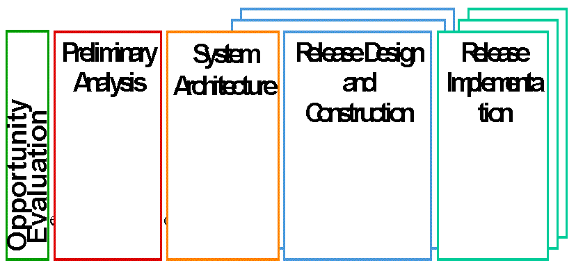
Figure 2. Methodology for developing the SIGER
CONTEXT OF THE SINGEO
The purpose of the system is to provide users with the tools for supporting data compiling and integration and the official generation of products, according to users’ needs. The system encompasses the following types of data:
- Documental data
- Cartographical data
- Topographical data
- Geological data
- Geophysical data
- Geochemical data
- Mining data
- Hydro-geological data
- Environmental data, among other
Fig. 3 shows the processes supported by the system and the relationships between them (the system encompasses all processes included in the grayest area of the diagram.)
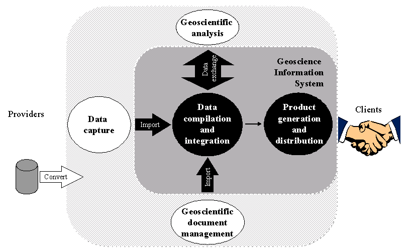
Figure 3: Context of the System
SINGEO ARCHITECTURE
- Data accountability involves two aspects: topics and territory.
- Product definition and representation will respond to users’ needs.
- Projects will be aligned with key products.
- Standards will be implemented at institutional level..
- Geo-scientific data compiling and integration is the responsibility of each technical area.
- Generation, (packing), and distribution of official products is the responsibility of the Information and Services Area.
System definition
The system is modular in structure and includes several subsystems, according to the institutional IGMX data model, and is based on the treatment required by the system to accomplish its objectives. These subsystems are:
- Work session management
- Document fund management
- Territorial data management
- Geological data management
- Geophysical data management
- Geo-chemical data management
- Mining data management
- Hydro-geological data management
- Environmental data management
- Product management
- System management
- Initial data base development
- System Modules and Data Model
INGEOMINAS has developed an implemented a database following an integrated and coherent conceptual data model called IGMX, (Fig. 4).
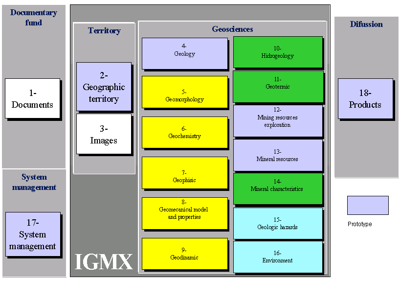
Figure 4. Institutional data model IGMX
Functional Principles
The system operates on the three main following principles:
- INGEOMINAS, must operate within a legal framework guaranteeing the availability of legal tools to insure acquisition of data from foreign agencies.
- Products must be defined according to users’ needs.
- Products must be standardized for use by different clients.
General Product List
Key products, at 1:500.000, identified by the institution to be initially supported by the system, are:
- The Geological Atlas of Colombia
- The Geophysical Atlas of Colombia
- The Geochemical Atlas of Colombia
- The Underground Water Atlas of Colombia
- The Metallogenic Atlas of Colombia
- The Mineral Resources Atlas of Colombia
- The Geochemical Anomalies Atlas of Colombia
- The Geological Threats Atlas of Colombia
Technical Guidelines
The hardware and software infrastructure includes the following components:
- SIG Software: Arc/Info y Arc/View, for data compiling, integration, search, and consultation.
- Sybase as Data Base Management System (DBMS), for descriptive data management.
- (Descriptive) data base Server
- Product Server
- PC Workstations
- Ethernet
IMPLEMENTATION STRATEGY
Considering the major scope of the system and its strong impact on the organization, the system is being implemented in several stages, each of which will allow the delivery of functional applications and benefits for the organization (Fig. 5).
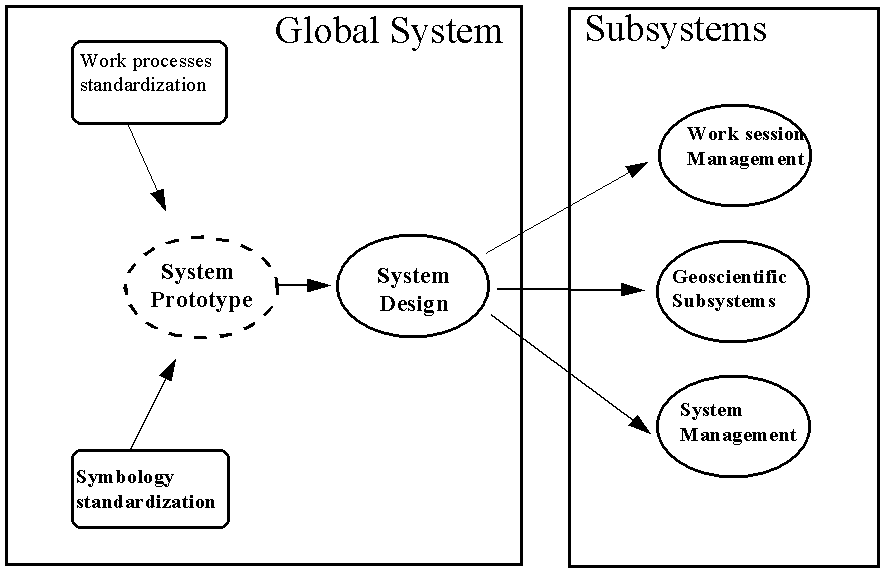
Figure 5. Implementation strategy
Standards Implementation
Prior to implementing the system, the organization must implement and use a large number of standards which, together with an adequate alignment of the system thereto, will insure that the organization obtains the benefits expected from the system. These standards are:
- Accountability for a single data type should fall on a single area, i.e., the compiling and integration of geology data are the responsibility of the Geology Area.
- Geo-scientific data are available to all areas of the organization. For instance, the Geo-physics area must be able to access all other data to use them it its projects.
- Definition of data-related standards: Definition of presentation forms, symbols, data representation, and legend of key products and their contents, which will lead to a single geo-scientific symbology for the entity and for the country.
- Definitions of standard work processes for a product type to always be developed and presented in the same way. This includes: the definition of standards related to data compiling and integration and to product generation and distribution.
Project Alignment
Prior to implementing the system, projects must be gradually aligned in key product preparation defined according to users’ needs.
Fast Product distribution in Hard Copy and Digital Form
To guarantee the success of the system’s implementation, the organization must be capable of rapidly delivering some tangible products. These must be quickly delivered to both internal and external clients. This is why the four best-structured products were chosen for this purpose.
PHASE 1 OF THE DEVELOPMENT AND IMPLEMENTATION OF THE SIGER, FOR 4 GEO-SCIENTIFIC PRODUCTS: GEOLOGY, GEOCHEMISTRY, METALLOGENICS, AND MINING INVENTORY.
This phase was divided in two stages: 1) detailed design and architecture of the SIGER, 2) Development and implementation of the SIGER.
Detailed design and architecture of the SIGER
The detailed design of the system was developed to describe the system’s mode of operation. This phase made it possible to establish the functional laws that will standardize the system, involving the following topics:
- High-level conceptual data model, a diagram showing the different entities and the relationships among them.
- Detailed conceptual IGMX V2.0 data model, a diagram showing the entities, their attributes and the relations among them. (Fig. 6)
- Functional data model, a diagram showing the entities, their associated attributes, and the characteristics of each of these attributes. (Type, default, etc.)
- Physical data model, implementation of the functional data model
- Functional principles, principles for system operation
- Function definition, description of unitary processes to be developed
- Functional rules, standards for system-user interface automated processing, etc.
- Organic rules, rules for unitary processes programming
- Technological environment, evaluation of and recommendations for the technological environment, including the network, the hardware, and the software. A new technological platform was proposed and approved for the SIGER (Fig. 7)
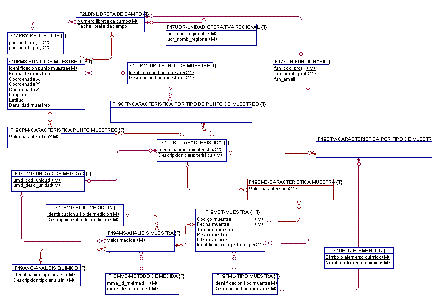
Figure 6. Detailed conceptual data model
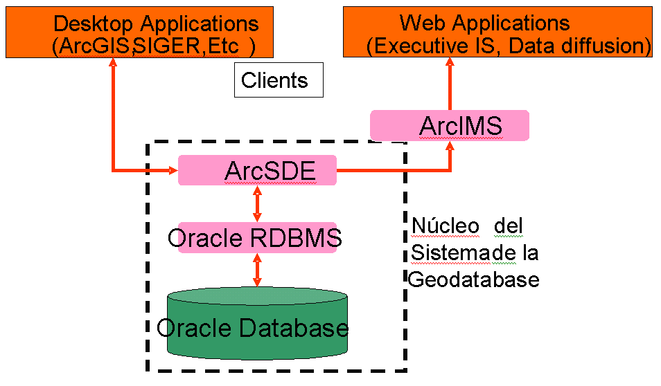
Figure 7. New technological platform
Development and implementation of the SIGER
The functional analysis for the different entities is conducted, the user interface description and the unitary process operations are made and validated; the code relating to functional specifications is generated, the functional test is performed, the system is tested, the system is implemented and users are trained. This relates to the following aspects:
- Functional specifications of unitary processes (Fig 8), a document for each unitary process to be developed, containing: the unitary process goal, user interface description (Fig 9), unitary process operation description and validation.
- Application, this is the code of all the unitary processes of the system, produced by programmers on the basis of functional specifications
- Functional test specifications, a result per each unitary process, it contains a description of test cases to confirm that each unitary process behaves according to functional specifications
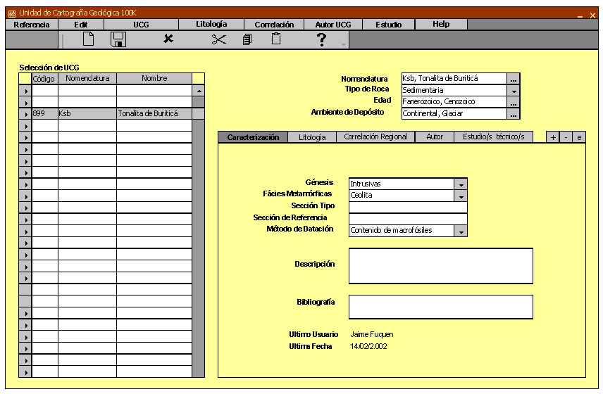
Figure 8. Functional Analysis
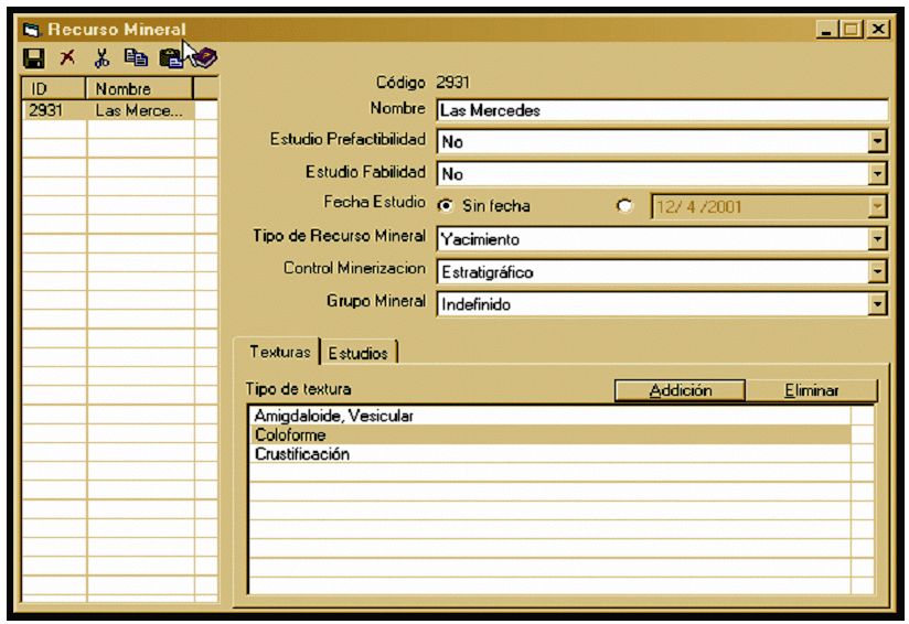
Figure 9. Graphic interface
- System test, testing to confirm that the system is capable of producing the four products. The entire process will be identified from the system’s inputs and outputs, real data will be used for this test (Fig. 10)
- Implementation strategy, description of when and how production processes will be implemented, it also describes the responsibilities of each step required for the satisfactory implementation of the system.
- Training material, documentation to support user training in system management
- Final report, includes the final versions of all results obtained during phase 1 and recommendations for future phases.
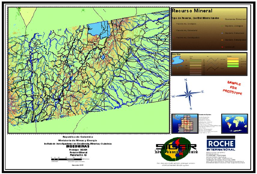
Figure 10. SIGER Test
CONCLUSIONS
- The fact of having a corporate data base will allow INGEOMINAS to accomplish institutional changes: Train staff on the use of the SIGER, adjust its production processes, acquire field data, continue to work in the definition of standards of the different geo-scientific topics managed by the institute
- Geo-scientific data will be kept in a corporate data base that will allow its updating and use by corporate technicians and by INGEOMINAS CLIENTS
- The SIGER will facilitate the process of obtaining institutional products in a standardized manner and in different formats: analog and digital
BIBLIOGRAPHY
DMR Group Inc., 1996. DMR Macroscope. P+OnLine. System Development Guide, V2.2.
INGEOMINAS, 1.997. Atlas Geológico Digital de Colombia.
Murillo, A., y otros, 1.994. Aplicaciones de un SIG en Geociencias, Modelo de Datos de Ingeominas, Área de Geología, Bogotá.
Roche International, 1.997. Geoscience Information System Preliminary Study, Santafé de Bogotá
Torres, H., 1.995. Análisis, Diseño e Implementación de una base de datos de geología, para el subsistema de información georreferenciada del Área de Geología del Ingeominas. Universidad Nacional de Colombia, Facultad de Ingeniería, Departamento de Ingeniería de Sistemas, Magister en Ingeniería de Sistemas., Santafé de Bogotá.
Torres, H., 1.998. Sistema de Información Geocientífica - Ingeominas, X Congreso Colombiano de Minería, Medellín.
United States Geological Survey, 1.995. Draft Cartographic and Digital Standard for Geologic Map Information