Nobody would disagree with the fact that developing a single layer of spatial data at country level, utilizing Remote Sensing and Geographic Information System (GIS) techniques, takes years. Governments, especially those of the third world; are investing a considerable amount of resources in the form of developmental grants and foreign aid to establish GIS in various institutions. However, it is a dilemma that these systems are often established without any inter-institutional coordination and thus result in highly incompatible (with each other) hardware, software and data coding procedures. Also such practices duplicate data and waste considerable effort and funds. This paper suggests that a single well-linked Geographic Information System is needed in Pakistan. It is proposed that a centralized, well-managed platform be established with various nodes at different locations. This is the only and the best way that a GIS can be a valuable and long-lasting asset in countries like Pakistan where developing and updating an information bank may become an impractical task.
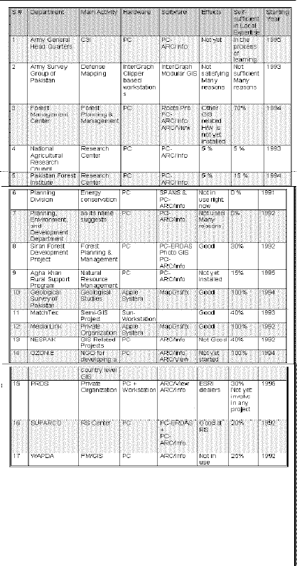
INTRODUCTION

With the adoption of the Pakistan National Conservation Strategy

(PNCS), Pakistan joins that group of countries which cares for

future planning and development within the context of a national

environmental framework. The ability to implement the

recommendations of technical experts, practitioners, and advocates

of good environmental practices, is the key to sustainable

development and changes within the country.


Pakistan is a densely populated country. With a population

growing rapidly at the rate of 3.2% annually, increasing pressure

is being placed on the nation's natural resources. Dealing with this

problem is made difficult by shortages of technical skills.


Apart from the issue of natural resource conservation caused by

rapid population growth, the accelerating pace of national

development due to rapid urbanization and infrastructure

development also creates an expanding need for more and better

information. This information in needed to ensure the efficient and

effective utilization of the resources being expended on these

facets of national development.


National priorities for dealing with resource management and

development issues are determined partly by international

obligations arising from international conventions to which

Pakistan is a signatory. Another significant influence shaping these

national priorities are the priorities of the donors of the aid which

Pakistan receives from the international community. This makes it

difficult to formulate a cohesive national strategy for coping with

the intensifying pressure on the nation's natural resources. But

given the limited resources and the skills limitations the country

faces, it is imperative that the country chooses carefully its

priorities for development


These choices are, of course, heavily dependent on the amount and

quality of information at the disposal of the nation's decision

makers, and when information itself is often limited and of dubious

quality, then the dilemma facing the country as it tries to advance

towards a "developed" state is obvious. The quality of spatial

information in Pakistan is a good example of the "information

constraint" facing the country.


SPATIAL DATA SOURCES AND ITS QUALITY IN PAKISTAN


GENERAL:

The quality of geographic data in Pakistan is erratic. Physical data

for some regions is reasonable, but in others is lacking. Statistics

are still rudimentary, maintained by or for specific departments and

usually are not correlated for general use.


BASE MAPS:

The Survey Group of Pakistan (SGP) is responsible for all base

mapping for the whole country. Unfortunately all such maps at 1:

100 000 or 1:25 000 scale are out of date. The topography and a lot

of other spatial information like roads, rivers, and place names,

forestry and other land-uses etc. were generated from field surveys

during colonial times. Periods of survey vary from 1906 to 1970.

Attempting to edge match adjoining map sheets will often betray

deficiencies in cartographic skills. Sometimes map sheet

parameters are defined in yards and miles and while others in

meters and kilometers. Only a spatial series has the national grid

printed on it.


AERIAL PHOTOGRAPHY:

SGP is also responsible for aerial photography but no up to date

aerial photographs (AP) are not available. In Pakistan's North West

Frontier Province for example, AP dates back to sixties and early

seventies and their utility has diminished due to rapid and

extensive changes in land use over the past thirty years. National

security concerns constrain both access to the exiting AP and the

opportunity for new aerial photography.


SATELLITE IMAGERY:

Commercially available satellite imagery provides a diverse and

increasing range of facilities for improving resource and

management. LandSat and SPOT cover all of Pakistan frequently.

Fortunately this technology is available in Pakistan. Pakistan's

Space & Upper Atmosphere Research Commission (SUPARCO) is

well equipped with Remote Sensing Interpretation facilities and

has also a small PC based GIS running PC ARC/INFO and ERDAS

software. Other sophisticated hardware is available for data

analysis. SUPARCO's technical expertise is involved in various

studies and in training in the use of remote sensing technology. But

SUPARCO's data procuring procedure, interpretation methods and

the accuracy of its work need improvement.


NEED FOR A SUSTAINABLE GIS


For the problems which Pakistan is trying to overcome GIS can be

valuable and long-lasting asset. Information can come from a wide

range of sources. To put it to the most effective use, there is a need

to integrate with the GIS data from many sources while

maintaining the integrity of the data itself. Sustainable

development of a GIS is however not an easy endeavor. "Where

should we begin?" and "How should we proceed?" are questions

that need particular attention. Clear priorities are needed, and

action should be based on these priorities.


Sustainable institutional development is needed in parallel with the

development of the GIS. Our institutions must be able to carry out

natural resources inventory with ground surveys; we need good

data management systems. We even need better methods for

maintaining proper land records which could be a vital component

of a spatial information system. Instead, repeated subdivisions of

private property as ownership passes from generation to generation

and lack of clear settlement of ownership rights to common

property have resulted in much litigation and uncertainty about

such basic data as land ownership. District revenue offices need to

upgrade land records and to open them to public inspection, a task

for which a GIS would be a great asset.


GIS CURRENT STATUS IN PAKISTAN


Presenting information through maps is a centuries old technique;

using computers to do it is recent. GIS softwares vary in their

features from simple map production to complex overlaying and

analysis. There are more than four hundred different programs for

automated mapping; of which some seventy are full GISs. Costs

vary from US $ 600 to US $ 30,000 and even more. Training needs

vary from a few hours to several weeks intensive programs.

Considering a country level database for Pakistan, involving a

massive amount of data and its extensive processing, PC

processing power is clearly inadequate so a workstation based GIS

will be needed.


The Government of Pakistan (GOP) is investing a considerable

amount of developmental grants and foreign aid in establishing

Geographic Information Systems and mapping facilities in various

institutions. These systems are however established without any

inter-institutional coordination and will thus result in highly

incompatible hardware and software, duplication of data and

inconsistencies of results. A considerable amount of foreign

exchange is also lost in the process. Table 1 describes the

current status of GIS in Pakistan.
PROPOSAL

A CENTRALIZED GIS SETUP


Maps are used for planning and development of natural resources,

command and control systems of defense and civil security and for

numerous other purposes. The responsibility for topographic

mapping and aerial photography lies with the SGP. SGP is a civil

organization which, for security reasons, is headed by a Surveyor

General and works under the strict control of Army General

Headquarters (GHQ). All departments which require topographic

maps make their request to SGP and many are permanently

registered with it for mapping and aerial photographs procurement.

It is therefore proposed that a centralized, well-managed GIS

platform be established in SGP with various sub-nodes at

ministries and sub-sub-nodes at different departments and its own

sub-offices at different locations. Diagram 1 is an example of the

proposed tree type Network.
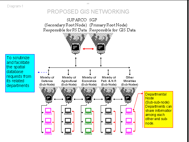
Availability of data in digital form is a prerequisite for a GIS, and

nobody would disagree with the fact that developing a single layer

of spatial data can take years using GIS/RS techniques specially in

a country like Pakistan where the quality of base maps is rather

questionable. New survey and conversion of existing archives of

basic scale maps into digital form is therefore an essential requisite

for establishing a nationwide GIS


Many of the governmental organizations may claim to be the

appropriate site for a centralized national GIS, but considering the

following points, it would appear that the SGP should logically be

allocated responsibility for this major undertaking.


*  All kinds of mapping and aerial photography archives are

already available in SGP.


*  Surveying and cartographic facilities an administrative

setup and staff already trained in some of the skills relevant to the

task are already at the disposal of SGP.


Hence new technology such as a Global Positioning System (GPS),

GIS or RS can be added on to the existing institutional capacity. A

satisfactory specification for the national archives of survey data

exists. Thus coding, labeling and annotation procedures can be

easily standardized and SGP can become an On-line Central GIS

Data Bank. Possibly SGP and SUPARCO could share some of

their expertise and facilities.


Security procedures can be easily implemented because the SGP is

under strict control of GHQ. SGP will be responsible for extending

the comprehensive digital data to various organizations with in the

country and abroad on request/payment. One of the major

advantages of SGP as a base is that the employees of SGP are not

transferable and once trained their expertise may be utilized

permanently in future. This is a welcome contrast to the situation

prevailing in many other government sector institutions where

frequent staff turnover hampers introduction of new technology -

especially the kind that requires extensive training - both "on the

job" and formal courses.


RECOMMENDATIONS:


*  SGP and other major users of SGP maps and spatial

information (SI) should collaborate with each other in the

establishment of a sustainable GIS at SGP.


*  SGP should convince basic scale digital mapping  users to

guide and help the development of an accelerated digital mapping

program with a future GIS data bank.


*  SGP should develop specifications for quality control, cost,

funding arrangements and timetables, for creating both basic scale

digital mapping and upgrade requirements.


*  SGP should develop a better update service for digital

mapping.


*  A program should be initiated for establishing a clear

understanding of GIS in the top management of Defense Ministry

and SGP.


*  Training in the modern surveying techniques and

equipment should be arranged before starting any further surveying

for digital mapping


*  SGP should establish standard some procedures for

recording topographic information in consultation with other

federal and provincial departments and


*  SGP should provide incentives to such institutions for

cooperating in these issues.


The ability to achieve truly integrated GIS depends on establishing

the appropriate information network. A Tree type network

methodology should be adopted by the SGP, SUPARCO and other

federal and provincial government departments. Information

should be shared between the central nodes and sub-nodes at

various locations all over the country.


Departments should be able to make a formal request through sub-

nodes at their premises or at their head offices after consulting  up

to date on-line dictionary provided by the central nodes.

Each department can have its own small scale on-site GIS facility

for overlaying, updating, and analyzing spatial databases according

to departmental needs. This will certainly reduce the duplication of

common data and lessen the training and  maintenance needs of the

departmental GIS sub-node.


CONCLUDING REMARKS:


In conclusion I would suggest that GOP should take some new

initiatives and measurements for establishing GIS and up to date

mapping facilities at SGP. SGP has to come out of its exclusive

possession strategies and must liaise with academic institutes as

part of its program of research and development for inter-

institutional coordination, command and control, planning,

development and most important digital terrain model (DTM).

Otherwise in the absence of reliable spatial information sustainable

and successful implementation of PNCS should not be expected.


ACKNOWLEDGMENTS:


I am  thankful to Mr. G A Neville: Chief Technical Advisor Forest

Management Center Peshawar and Dr. Syed Hamidullah:

Associate Professor of Environmental Geology at the National

Center of Excellence in Geology Peshawar University. for their

critical reading and  editing of the paper.


I am also extremely grateful to the Mr. Thomas Wernly,

Ambassador of Switzerland in Pakistan for the financial assistance

to attend Esri's user conference and Mr. Naveed Zaheer Mirza

from Pakistan Resource Development Services for complimentary

registration.


REFERENCES:


1. IUCN and GOP. The Pakistan National Conservation Strategy

(PNCS). April 1992. IUCN Karachi Pakistan.


2. Schmid, Peter. Use of GIS and RS in the Forest Management

Center of NWFP Pakistan. July 1994. Peshawar Pakistan.


3. Lord Chorley. Handling Geographic Information: Report to the

secretary of state for the Environment of the Committee of Inquiry

into the Handling of GI. Second Impression 1988. London: Her

Majesty's Stationary Office UK.


4. Seppe Cassetari. Introduction to Integrated Geo-Information

Management. First edition 1993. London UK:Chapman & Hall.


5. G.A.Neville. A GIS & RS in the Forest Management Center: A

Discussion Paper. June, 1994. Peshawar Pakistan.


6. IUCN and GOP. Sarhad  Provincial Conservation Strategy

(SPCS):Inception Report. October  1993. IUCN - SPCS Unit

Peshawar Pakistan.


7. Stan Aronoff. Geographic Information Systems: A

Management Perspective. Ottawa, Canada:WDL Publications.


8. Fazle Karim Khan. A Geography of Pakistan: Environment

People and Economy. Karachi Pakistan: Oxford University Press.


9. P.A.Burrough. Principles of Geographic Information Systems

for Land Resources Assessment. First Publication 1986, Last

reprint with corrections 1994. USA: Oxford University Press.
Current Activities:
My work as GIS Consultant in FMC is to support and assist for a
sustainable development of a Geographic Information System.
This includes training, maintenance and promoting a better
appreciation of GIS technology in NWFP and Pakistan by
providing GIS demonstrations, presentations and by writing about
GIS.
Previous Experience:
I have a six year experience of developing Geographic Informatio
System at different reputable organizations. My experience
includes working with USAID (Afghanistan), UN, Pakistan Army
and different Government and other Non-government offices.