ABSTRACT
Wuhan is the capital city of Hubei province, P. R. China. The shifting from planned economy to market economy has been a great challenge to the Urban Planning Bureau under the municipality. The challenge lies partially in finding new land for urban expansion as well as redeveloping within the inner cities. Under these circumstances, the Urban Planning Bureau initiated two projects: the Wuhan Master Plan Revision, in which the Spatial Development Plan forms an important part, and the Urban Renewal Planning in inner cities. The advantages of PC ARC/INFO were taken in both of the pilot studies, and the results were quite satisfactory. Based on the experience gained from the two projects, the paper also discussed some technical problems and made some suggestions.
Under the background of economic reform in P.R. China, Wuhan is facing many chances of development. The open door policy in coastal areas, the redevelopment of Pudong in Shanghai, and the initiation of the famous Three Gorges have created a favorable regional economic environment for Wuhan. On the other hand, as it is the hub of railroad, highway and waterway in central part of China, Wuhan has the great advantage in transportation. All these have provided Wuhan with the golden opportunities of booming in central China.
The opportunities are also great challenges to the municipality if considering the current situation in Wuhan. The need for finding new spaces for living and developing is restrained by many factors such as the Yangtze River, the widespread lakes around. With the adjustment of industrial structure and under the pressure of redevelopment in the inner city, the built up areas of Wuhan will unavoidably expand.
To respond to the shift from planned economy to market economy, the municipality initiated the Revision of Wuhan Master Plan, in which the Spatial Development Planning forms an important part. The prerequisite of the planning is the land suitability analysis.
The first step of the land suitability analysis is to find factors which constrain the development of the city. Such factors as land use, land form, land morphology, engineering geology, water supply and disaster prevention are evaluated and mapped on scale of 1:100,000, with total area around 9000 square kilometers of the municipality. The evaluation of these factors is by classifying areas into three or four levels according to their qualities for each factor, and by weighting these factors according to their importance.
For the factor Land Bearing Capacity, three grades are differentiated:
first grade: land bearing capacity is BIGGER than 15 tons per square meters
second grade: land bearing capacity is BETWEEN 10 to 15 tons per square meters
third grade: land bearing capacity is LOWER than 10 tons per square meters
For the factor Land Form and Flooding Prevention:
first grade:
second grade:
third grade:
For the factor Land Use suitability:
first grade: the areas unsuitable for agriculture
second grade: the areas with high agriculture productivity
third grade: the areas protected for scenery, woods and water areas
For the factor Disaster geology:
first grade: areas free from earthquake
second grade: areas with less earthquake destruction
third grade: areas influenced by earthquake
For the factor Transportation:
first grade: areas around intersections between first grade roads, first and second grade roads
second grade: areas around intersections between second grade roads, first and third grade roads
third grade: areas around intersections between second and third grade roads, the towns along first and second grade roads
Besides the factors acted as restrains to the analysis, several other factors which can act as impetus to the development. These impetus factors include power supply, water supply, ports, railway stations, airports and so on. They are made use of only for qualitative analyses. Based on the output of the individual reclassified maps for each factors and the land suitability evaluation map made from overlay of all these factors according to response weights as well as some other important elements like the total population and the size of present towns outside the built up area of Wuhan, the site selection has been made in three classes for the further development in the coming 20 years.
With the implementation of transformation from planned economy to market economy and the new policy of land lease, a great amount of investment from Hong Kong, Taiwan as well as other countries have been attracted for the real estate development especially in the inner city. the planning department can hard cope with situation on the one side many applications are to be checked, on the other side lack of efficient tools to access many of required data as well as many of the data are out of date and incomplete.
In order to solve the problem, a pilot project started in 1993, cooperated with the International Institute for Aerospace Survey and Earth Sciences (ITC), the Netherlands. Therefore a typical area of 470 hectare (13 streets from two districts) has been selected as study area. The following aspects are included:
(1) Building
All the buildings have been digitized from the topographic map (scale 1:2000) and following attributes have been included:
--- Building ID (9 digits, First digit-- District Code, Second and third digits-- Street Code, Forth and Fifth digits-- Resident Committee, Sixth digits-- Block Code, the Last Three Codes-- Individual Buildings).
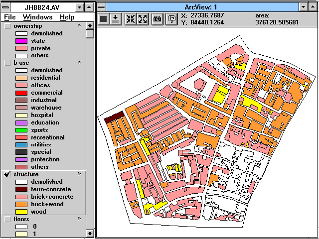
--- Building Usage/Function (Residential, Offices, Commercial, Industrial, Warehouses, Hospitals and Health Centers, Education and Research, Sports Facilities, Recreational, Utilities, Special function, Historical Buildings, Others).
--- Building Structure (Ferro-concrete, Brick-concrete, Brick-wood, Wood, Others).
--- Ownership (State, Private, Others).
--- Number of Floors.
--- Remarks for the Historical Protection.
(2) Land Use
--- Land Use ID (6 digits, First digits-- District Code, Second and third digits-- Street Code, the Last Three Codes-- Individual Buildings).
--- Land Use Code (According to the National Standard of Classification for Urban Land Use, including 10 Primary Classes, 46 Secondary Classes and 73 Detail Classes).
(3) Land Transferring
--- Land Use ID (6 digits, First digits-- District Code, Second and third digits-- Street Code, the Last Three Codes-- Individual Buildings).
--- Developers or Investors (Name, Type, Amount of Investment etc.).
--- Function of Individual Plot to be developed.
Other aspects including Road and Planned Road, Water Supply, sewage, Electricity, Cables, Gas Pipes etc. To update the map (the latest topographic maps were revised in 1988), An set of aerial Photographs have been taken by using Light Aircraft (the Power Glider) and Small Format Camera (Rolleifliex).
(1) PC ARC/INFO is capable in these projects, especially for Spatial Analysis in Planning stage and daily Urban Planning Management where updating of graphical and attribute data are their own responsibility and a great benefit can be made.
(2) PC ARC/INFO can meet the demands of urban planning and management in small cities and the district level in big cities in China due to a limit amount investment is available in most cases while Workstation version is preferable in big cities.
(3) Some suggestions based on PC ARC/INFO 3.4D plus:
To reach consistency of graphical accuracy, the Snap Distance is preferable to be able to set to the ground resolution i.e. one meter or ten meter instead of a relative value.
An Undo function is recommended in ArcEdit Module, the reason is that when user wants to move a Node, but Edit feature remain in Arc and forget to set to Node, the MOVE command can make a serious problem.
1. PC ARCEDIT User's Guide (V. 3.4D plus), Esri, 1992
2. National Standard of Classification for Urban Land Use GBJ 137-90, the Ministry of Construction P.R. China, 1990
3. Stan Aronoff, Geographic Information Systems: A Management Perspective, WDL Publications, 1993
4. D. R. HOWE, Data Analysis for Data Base Design, Edward Arnold, 1989
Huang Zhengdong
ECURSPAM
Wuhan Technical University of Surveying and Mapping
39 Luoyu Road, Wuhan 430070, P.R. China