Linda Culp, and Mark Woodall
Although the increase in ridership outpaced the growth in population, this growth has slowed dramatically since 1990, and in fact has declined since 1993. The local economy has experienced a recession, with regional job loss at more than 45,000 (2 percent) between 1990 and 1992. Local, state, and federal funding has tightened during this same period. Given these trends, the need for more effective planning and marketing of existing transit services has increased.
Other databases are maintained at SANDAG and frequently requested by transit operators. Regional growth forecasts are compiled for the region, cities, and communities for the years 2000, 2010, and 2015. Historical, current, and forecasted data (including population, housing, and employment estimates), crime statistics, and land use databases are also maintained. All of these databases are maintained by geographic coordinates, allowing them to be analyzed using a geographic information system (GIS). Transit operators often request data from several of these sources to be integrated and analyzed by various alternatives for a specific geographic area (examples include a future light rail corridor or an area surrounding a particular transit stop). These types of technical requests have been frequently handled by SANDAG using ArcInfo.
For several years, SANDAG has integrated GIS and long-range transit planning models to produce passenger forecasts of light rail extension studies. In the early 1980s, SANDAG developed a short-range transit planning PC application that was used by the operators directly to determine the population and employment within walking distance to proposed transit lines. GIS has also been used by SANDAG staff to develop maps and information for other transit planning projects.
Public transportation services in the San Diego region are provided by seven operators and are integrated into a coordinated regional system through agreements on fares, transfers, and public information. Two agencies provide overall coordination. The Metropolitan Transit Development Board and North County Transit District prepare short range transit plans annually with technical assistance and data provided by SANDAG. The five local operators also conduct transit planning in their service areas. SANDAG and each of the transit operators have developed a good working relationship and coordinate on all major public transportation studies in the region.
Currently, SANDAG and the region's operators are working together to develop and maintain a GIS application in ArcView 2 that staff from each individual operator can access directly. SANDAG chose ArcView 2 because of its compatibility with existing SANDAG databases and the fact that it provides GIS functions for non-GIS users. In the past, because of the specialized nature of GIS and extensive training required of staff, GIS services have been pooled at SANDAG and provided to operators on request. With the significant improvements that have been made in the field of GIS and personal computers, it is now possible to develop a PC-based GIS application that is user-oriented at a relatively low cost. Such applications are directly accessible by the region's transit operators, but periodically maintained by SANDAG. In addition, operators can request SANDAG to develop new GIS applications (i.e. transit marketing applications).
Direct Access: V2T gives operators more direct access to commonly used information previously provided by SANDAG. For the first time, operators are able to integrate information that is collected and maintained in-house using this system.
Geographic Analysis: V2T allows for analysis of data at various geographic scales, with the base geographic area smaller than a census block. Buffering and aggregating to virtually any size study area are more accurate, from the immediate area surrounding a transit stop or route to entire service areas.
Data Integration: V2T provides the operators with the capability to integrate data from a variety of sources. A common request from operators is to provide socio-economic data for areas surrounding a busy transit route. This type of integration is a central feature in the application.
Ease of Use: Perhaps the most important objective of V2T is that it is a GIS for non-GIS users. Transit operators are able to use this application with minimal training time and expense.
At the start of the project, a development committee was put together with staff from SANDAG and the transit operators. This committee designed the elements of the project, formulated responsibilities and time schedules, and discussed relevant applications. The group compiled a list of these applications to be included in V2T and reached consensus on a base set of applications including:
· Analyzing the socio-economic characteristics of areas surrounding transit routes and individual stops.
· Analyzing transit ridership by stop by time of day.
· Analyzing the physical characteristics of transit stops.
· Analyzing future growth areas for transit.
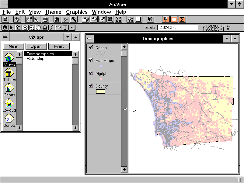
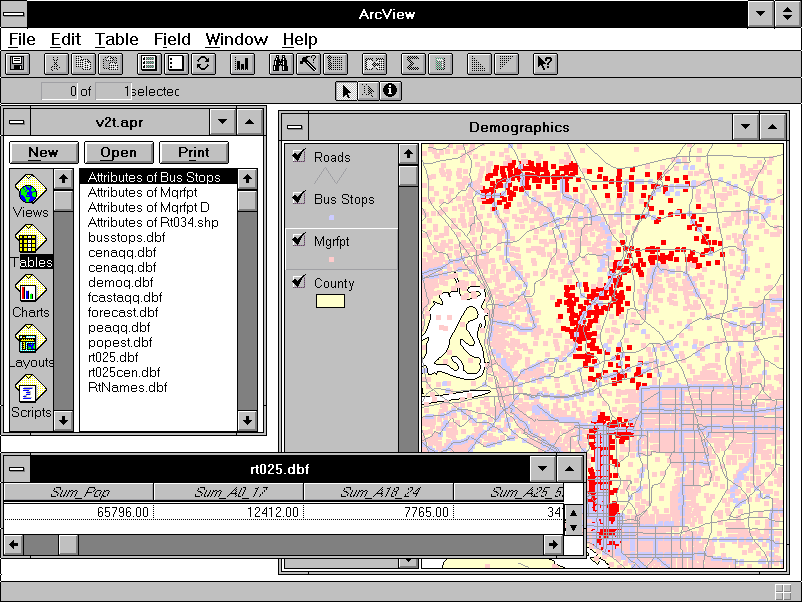
Both views use a county boundary theme and a major roads theme to offer visual references to locations within the region. Both views also use a bus stop theme. Features of this theme are depicted as points. Each point represents a bus stop/route combination. Using the identify tool in ArcView, the analyst can obtain detailed information about a particular stop.
Detailed geographic selection is possible in the demographic view through the MGRA theme. An MGRA (Master Geographic Reference Area) is the smallest unit of geography for which SANDAG provides information. It is generally the size of a census block, though may be smaller in some cases. There are over 25,000 MGRAs in the San Diego region. This level of geographic detail is required in SANDAG's overall modeling efforts to assure that data can be aggregated to any of the political or administrative boundaries that currently exist. In V2T the geographic detail of the MGRA theme boosts the accuracy of geographic selection, especially when the analyst asks the system to retrieve information about people who reside within a specified distance of a bus stop or collection of bus stops. This is a very common task in V2T and geographic accuracy is crucial to the process.
Although MGRAs possess shape and area, they are represented as points in V2T because of the performance penalties suffered when the system draws that many polygons. Polygon-filled maps are sacrificed in the trade-off for performance, but the transit operators did not specify this capability during the design phase.
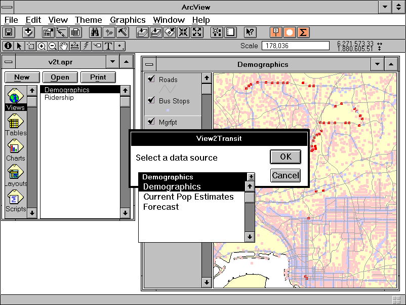
Once a set of MGRAs is selected in the demographic view, V2T offers a choice of three databases for summarization: demographic, current population and housing estimates, and regional forecast data.
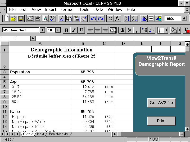
Grounded in the 1990 Census, the demographic database contains detailed demographic data, including age and sex breakdowns, household income distributions, mode to work (i.e. drive alone, carpool, transit, walk, etc), vehicle availability, and other characteristics of the residential population pertinent to transit planning and marketing. Employment by place of work is also included, giving the analyst information by place of residence and place of work in one database.
The estimates database yields information for more recent estimates of population and housing. This database includes housing units, occupied units, population, and group (civilian and military) quarters population for the years 1993 and 1994. This database is updated annually by SANDAG.
The third database that may be selected is the forecast database, which has population and housing forecasts for the years 1990, 2000, 2010, and 2015. This database is drawn from SANDAG's Series 8 Interim Forecast which has been sanctioned for planning purposes but is subject to change. The database will be updated as needed.
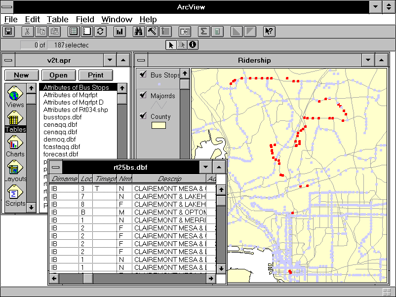
In the ridership view, summary and detailed transit ridership characteristics can be analyzed for a particular route. The transit stops database used by this application contains detailed information for each transit stop along each route in the region. For example, the analyst can determine which route(s) serve the stop, whether or not a shelter is present at the stop, and how many boardings and alightings occur at the stop on a typical weekday by time of day. These data are collected as part of SANDAG's Passenger Counting Program and are updated annually.
Occasionally, the analyst uses V2T to obtain a single statistic, such as the population within one mile of a park-and-ride lot. ArcView 2's on-screen presentation of data in tabular format is sufficient in this situation; the analyst scribbles a number or two and goes on. More frequently, though, the analyst seeks a number of statistics for a collection of routes and alignment alternatives. Because of this need to facilitate comparative analysis, and because ArcView 2's strengths lie in areas other than report writing, the V2T system includes several Excel 5.0 spreadsheets that provide both functions.
By virtue of ArcView 2 defaults, spatial queries in V2T return answers in a dBase file format. V2T permits the user to save these result tables under a name and directory of the user's choosing. The analyst can bring these tables into pre-formatted Excel spreadsheets and print them. The spreadsheets are designed under an assumption that the analyst has little or no experience with spreadsheets in general and Excel in particular. Clearly marked buttons perform everything from importing tables to printing information to changing the subject of a graph.
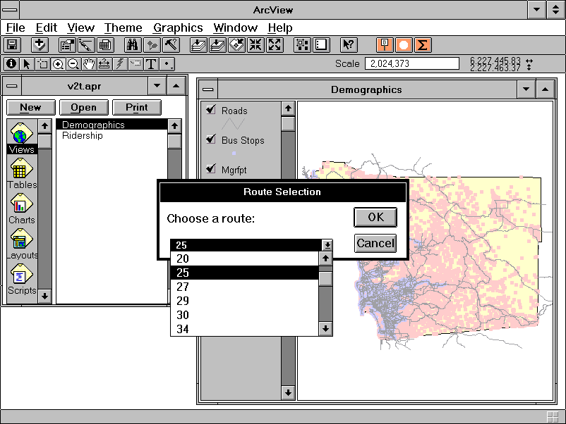
Question: What are the socio-economic characteristics of residents within walking distance to the bus route 25?
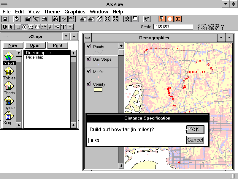
The demographic application in V2T contains the county boundary, MGRA, transit stop, and major roads themes (Figure 1). The Route 25 is first selected from the list of all transit routes using the first of three customized buttons (Figure 2). V2T then selects all stops for the route and highlights them on the view. By using another customized button, the area surrounding the Route 25 is defined as the MGRAs within one-third of a mile (Figure 3). Once these MGRAs are selected and highlighted, either the demographic, population and housing estimates, or forecast characteristics can be summarized (Figure 4). Figure 5 shows the resulting table of summarized data. Customized Excel spreadsheets provide a relatively easy means of generating output. Figure 6 shows a customized spreadsheet in which the dBase file is input and automatically formatted.
The result is a summary of the socio-economic characteristics of the 65,796 residents who live within walking distance to Route 25. Of note is the fact that 8.4 percent take public transportation to work, a much higher proportion compared to the region (3.3 percent).
Question: Since a relatively high proportion of residents use public transportation, including the bus, where are the busier segments of Route 25?
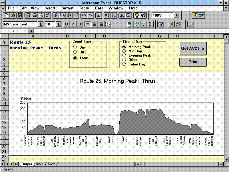
The ridership application in V2T contains similar themes. The Route 25 is selected in the usual way. Using one of the three customized buttons, a detailed ridership table is generated showing the activity at each individual bus stop (Figure 7). A customized Excel spreadsheet is also available which uses this table to create a chart of activity, in this case passengers riding through a particular stop (Figure 8). This spreadsheet can be used to determine the busier segments of the route during various times during an average day. (Note: The chart in Figure 8 shows both directions of the route. The "valley" in the middle of the chart indicates the directional change from inbound to outbound.)
Technology is emerging which puts more effective tools directly into the hands of transit planning and marketing staff, and this is the case with desktop GIS applications. Projects which have previously been done in-house by SANDAG GIS staff can now be done by the transit operator, with tools provided by SANDAG staff. The benefits to the transit operator include more immediate answers, the ability to ask related questions more easily, and new applications (e.g. incorporating in-house data). For SANDAG staff, resources have been freed up to work on other transit projects as well as additional V2T applications and functions.
One of the objectives of V2T is to provide GIS to non-GIS users, including preprogrammed functionality. While in-depth knowledge of ArcView 2 is not necessary, the more familiar the transit analyst is with the software, the more results are possible especially in other areas not specifically related to the two applications in V2T. These include incorporating data not maintained at SANDAG and functions such as addressmatching. Using V2T to obtain more knowledge of ArcView 2 will be of great value.
To date, V2T is in the beta testing stage. Two transit operators are acting as beta sites and evaluating the overall project, performance, databases, buttons, and user's documentation. General release of version 1 is due in June 1995. Also at that time, there will be a one-day training session for interested transit professionals including hands-on training in ArcView 2 and View2Transit.
This study illustrates the level of cooperation and the effective working relationship which exists between SANDAG and the transit operators providing service in the San Diego region. Questions such as analyzing the alternatives to a new trolley line, to identifying the potential riders of a bus route extension, to analyzing boardings by time of day can now be answered more easily. Planning and marketing efforts to enhance the current level of transit service and increase ridership are benefiting from View2Transit.