ABSTRACT Despite the recent spread of CAD and GIS Technology in Greece, most of the employees of the Technical Services of the Municipalities, are still using old traditional techniques in map designing.
Although many relevant research projects have been elaborated by Universities and other research organizations, the difficulties in applying their results to the daily working procedures of the technical stuff of the Municipalities are huge.
This happens firstly because these results applied in a theoretical level, without beeing accompanied by user friendly tools and techniques, make the establishment of a GIS system hard. Secondly the employees are not motivated to learn and use the new methods in their daily work.
In the Dept. of Topography of T.E.I. of Athens, where we focus on the application of scientific innovations, we strongly believe that all these new systems of map designing will have extremely good results in every day practice, if they are user friendly even to non-experts.
This belief is supported by the succesful research project we made for Municipality of Markopoulo, after a request made by Muncipal Society for Developement of Markopoulo (M.S.D.M.). What we had to do was to design with the SML a user friendly interface based on Arcplot of PC-ArcInfo, for this concrete region of Attika. We used pull-down menus and helpfull screens, in which we tried to describe in very simple Greek, what the user had to do, so as to design and illustrate easily and quickly a large rate of thematic maps for daily use.
INTRODUCTION
Within the scope of Municipal Society for Development of Markopoulo
(M.S.D.M) activities, for the creation of a Cartographic Information System
whose aim would be the efficient use of a digital spatial information
background, the Dept.. of Topography of Technological Educational Institution
(T.E.I) of Athens was assigned to research into the technical and financial
possibilities of an Automated Cartographic Information System in the
Municipality.
The research process was part of the application of a project called
"Business Competitiveness" which was financially co-supported by the
European Communities Social Fund (E.C.S.F). This project promotes the
co-operation between Universities and the Business World.
The final proposal, which was submitted by Andreas Tsatsaris and Tomas
Antoniou in April 1994, through the Dept. of Topography of TEI Athens and
concerned the actions and the realization stages, was approved by the
Ministry of Labor in September of 1994.
Following the approval, the project was financed by E.C.S.F. (75%) and
M.S.D.M. (25%).
The research team which was formed to realize the project consisted of:
Project Leaders
prof. ANDREAS TSATSARIS, Surveyor Engineer of National Technical University
of Athens (N.T.U.A.).
Lecturer at the Dept. of Topography of
Technological Educational Institution (T.E.I.)
of Athens.
prof. TOMAS ANTONIOU, Surveyor Engineer of T.E.I. of Athens.
Laboratory Lecturer at the Dept. of Topography of
Technological Educational Institution (T.E.I.) of
Athens.
Scientific Contributors
prof. DIMITRI KATSIERIS, Surveyor Engineer of National Technical University
of Athens (N.T.U.A.), Msc in Remote Sensing of
University of Delfth.
Dean of the Faculty of Technological Applications of
T.E.I. of Athens.
prof. DIMITRI TSOUROPLIS, Surveyor Engineer of National Technical University
of Athens (N.T.U.A.).
Head of the Dept. of Topography, of T.E.I. of
Athens.
prof. ELENI PETSA, Surveyor Engineer of National Technical University
of Athens (N.T.U.A.).
Lecturer at the Dept. of Topography of
Technological Educational Institution (T.E.I.)
of Athens.
Assistant Research Staff
SERAPHIM ALBANIDES, Surveyor Engineer of T.E.I. of Athens.
Agelos Agelakis, Surveyor Engineer of T.E.I. of Athens.
George Aerakis, Surveyor Engineer of T.E.I. of Athens.
Konstantine Astaras, Surveyor Engineer of T.E.I. of Athens.
Konstantine Foskolos, Surveyor Engineer of T.E.I. of Athens.
Anastasia Delipalta, Surveyor Engineer of T.E.I. of Athens.
Maria Evangeliou, Surveyor Engineer of T.E.I. of Athens.
Sotiria Marini, Surveyor Engineer of T.E.I. of Athens.
Epaminondas Valtinos, Surveyor Engineer of T.E.I. of Athens.
Evangelos Mendonidis, Surveyor Engineer of T.E.I. of Athens.
1. MENTION OF THE ACTIONS AND GOALS OF THE PROJECT
The project focused on the following briefly mentioned actions:
a. Recording of the problems concerning ways of the production of automated
cartographic compositions in combination with the information
which emerges from the problems of this particular Local Community.
b. Collection, classification and scale of existing data connected with the
detected problems.
c. Detection and valuation of the interdependency of the problems.
d. Development and formulation of the Methodology through witch the
visualization of data is feasible.
e. Documentation of results.
1.1. The project Goals
Medium-term Goals
a. Creation of the conditions necessary for the right use of the project
results on M.S.D.M. and the Municipal Council part.
b. Installation and experimental function of the producted software
(Municipal Map), for the automated production of cartographic compositions
in the real life working conditions.
c. Exploration of the applicable possibilities within the grid of Municipal
activities.
d. Self-financing possibilities of the Automated Cartographic Information
System.
Long-term Goals.
a. Creation of a digital cartographic background in the Municipal of
Markopoulo and installation of a geographic data base of such a form that
the data could be directly usable in the National Cadastral without any
further expense.
b. Development of a Multimedia Spatial Information System (MSIS).This
system will manage spatial information concerning any specific spatial
Municipal unit, providing the user with multiple form data, (vectorized
data, satellite images, aerophotographs, simple photographs, texts,
statistical data, etc.), which will enable him/her to update, edit, study
and analyze spatial phenomena in wide scale.
2. THE STUDY AREA
2.1 A general view
The Municipality of Markopoulo in Attika is situated about 30 km east of
Athens and borders on:
North with Municipalities of Spata and Peania.
South with Municipalities of Keratea and Communities of Kalivia Thorikou
and Kouvara.
West with Municipalities of Peania and Koropi.
East with Gulf of Evoikos.
According to the National Statistical Services of Greece the area of
Municipality of Markopoulo is 81,844 square km. As far as its area is
concerned Municipality of Markopoulo is the 7th Municipality in Attika and
occupies the 2.80% of the whole prefectures area.
It is very important to report here, that the 66.70% of the whole
Markopoulo's area, (54,611 sq. km), is rural area.
The kind of land under crop and the areas which are irrigated are mentioned
in the table bellow:
Kind of Land under Crop Irrigated (sq. km) Not Irrigated (sq. km)
Vineyards 27,840 4,300
Abroriculture areas 8,020 420
(Olive-tree areas 4,900
Pistachio-tree areas 1,500
Almond-tree areas) 500
Arable areas 485 105
Horticultural areas 448 448
Fallow areas 8,909
(Source: Ministry of Agriculture. Direction of Statistics. Year 1993).
Despite the fact that there are a few mountains with low altitude, such as
Merenda (614.00 m.), Kastro (429.00 m.), Korifi (400.00 m.) and others
surrounding the Municipality of Markopoulo, it has been characterized as a
flat area, which has an average altitude of 80 meters.
Most of the 20 Kilometers of the area's coastal zone are exploitable
beaches.
2.2 History
Historically Municipality of Markopoulo seems to be in the same location
from the mythical years. According to Archaeologists, seven of the twelve
cities of Kekrops were established into the present boundaries of
Municipality of Markopoulo. In short:
The ancient Municipality of Prasies which then was a port, nowadays is the
settlement of Porto Rafti which is also a port.
The ancient Municipality of Vravrona is nowadays Vravrona, where recent
archaeological excavations have brought to light the remains of the ancient
settlement.
The ancient Municipality of Kithirou is nowadays the region of Kipi with a
significant number of archaeological finds.
The ancient Municipality of Kikina is nowadays the region of Kiknia with a
lot of archaeological finds, too.
There are three more regions where the archaeological excavations brought
out a large number of finds. The ancient Municipality of Angelis is
nowadays site of Angelisi. The ancient Municipality of Mirinnounta is
nowadays site of Merenda. Finally the ancient Municipality of Agnounta is
nowadays site of Skoundra.
2.3 Population
Every ten years the National Statistical Services of Greece conducts the
general census.
In the table bellow are mentioned the results from 1981 and 1991 census,
for the Municipality of Markopoulo:
District Areas Popul. 1991 Popul. 1981
Markopoulo (center of the Munic.) 4,109 6,116
Agia Triada 77 -
Vravrona 81 -
Koulidas 185 288
Poria 6 -
Hamolia 130 -
Porto Raftis 3,238 2,984
TOTALS 9,826 9,388
(Source: Census Greece 1981 and 1991. National Statistical Services of
Greece).
2.4 Economy
The percentages occupational allocation of the financially active
population of the Municipality of Markopoulo, according to the sectors of
economic activity are:
Primary Sector 18.40%
Secondary Sector 36.50%
Tertiary Sector 45.10%
(Source: Financial statistics for the Municipality of Markopoulo. National
Statistical Services of Greece).
Whereas one should expect that because of the large extend of the rural area
the financially active population of the Municipality of Markopoulo would
be mostly occupied in the Primary Sector of economy, the major occupation
of the population is in the Tertiary Sector.
Generally, with a small declination in the Secondary Sector the same goes
for the rest of Attika's Prefecture, as far as occupation of the population
is concerned.
This switch from Primary to Tertiary sector is believed to have happened
mostly because of two reasons. Firstly, due to the weakening of the rural
partnership "MARKO" which was founded in 1914 and crucially contributed to
the development of the Municipality of Markopoulo; secondly, because of the
enlargement of the Porto-Rafti settlement which in combination with the rest
of the coastal zone and its Port, is today not only an important trade and
transportation seaway junction, but also a successful holiday resort.
3. THE USER INTERFACE "MUNICIPAL MAP".
From the brief description of Markopoulo we have already seen, it follows
that a Municipality with such a variety of activities and spatial phenomena
is worthwile being integrated and analyzed through the GIS technology.
It should be noted that in Greece, there is only a small number of
Municipalities which are simultaneously Urban, Rural, Industrial,
Archaeological, Mining and Coastal areas.
However, in the most of those Municipalities there are not trained
technical employees able to work and carry through a project using the new
technology.
So, in the Dept.of Topography of Athens T.E.I. the aim of this project had
to focus on two different aspects:
Firstly, to design a user friendly even to non experts interface, which
should be developed by means of a time honoured GIS system and secondly,
the designing should be open and dynamic to technological and institutional
evolution.
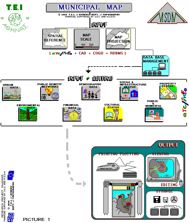
Finally the project was based on the PC ARC/INFO and the user interface was
designed through PC ARCPLOT. The bellow information mentions the kind of
data we had in our command, the design of the geographical database and the
thematic layers identified.
3.1 The primary Cartographic material.
The primary Cartographic material we used as background in database design
is mentioned in the table bellow:
Service Direction Departement KIND OF CARTOGRAPHIC
MATERIAL
National Statistical Census Cartographic Topographic Maps for the
Services of Greece Center and Port of
Markopoulo.
Scale 1:5000
Hellenic Military A' Providing 1. Topographic Maps for
Geographical Service the whole Municipality
Scale 1:5000
2. Topographic and
Thematic Maps for the
whole Municipality.
Scale 1:50000
3. Aerial Photographs
for the Center of the
Municipality.
Scale 1:16000
4. Coordinate locations
of the
National Triangulation
Network in Azimouthal and
and Equid-dist.projection
Ministry of Planning Surveying Applications Town Planning Maps for
and Public Works the Center of the
Municipality
Scale 1:2000
Athens' Municipality Topographic Maps for
the whole Municipality.
Scale 1:10000
Technical Services of Topographic Maps of
the Municipality of applications for the
Markopoulo accession of new areas
in the town-planning.
Scales 1:1000
1:500
3.2 The logical design of the Geographical Database.
Good database design ensures not only the smooth progress but also the
success of the whole project. Professional analysts usually underline the
significance of this step, because a well-designed database saves time and
money during the development of a project. It is very important to have
all the necessary geographic features at the time of the analysis instead of
spending energy during the "real thing".
Our demands, which were our guide in the geographical database design, are
mentioned bellow:
Database design must ensure:
a. Rapid and clear localization of an area according to Spatial Reference
of the Municipality.
b. The ability to use the whole already existing cartographic material for
editing and simultaneously allow the user to choose according to his
demands map compositions in any scale and any projection.
c. The ability to represent "the real world" as fields of the database, in
an easy and comprehensible way to any user.
d. The ability to look for, manage and represent any component of the
database, in the boundaries of the Municipality.
e. The necessary accuracy for every cartographic production, which ought to
fluctuate according to the user's demands.
The Geographical database consists of the bellow general entities:
1. Spatial Planning
2. Urban Planning and Cadastral Status
3. Natural Environment and Limitations
4. Substructure, which devides into four subunities:
4.1 Public Benefit Networks
4.2 Social Status
4.3 Cultural Status
4.4 Public and Municipal Services
5. Geographical Financial Definitions.
3.3 Data layers and attributes.
The geographic features that should be included in the database are
determined. The class used to describe each feature is decided and the
associated feature attributes are identified, depending on the requirements
of the analysis and map products.
The particular research project involves the following criteria:
a. The existence of a cartographic background, which should be
appropriate for representation of any geographical data.
b. The ability to use a significant number of locations, which belong to
the National Triangulation Network.
c. The localization of distinct areas, where a considerable range of
natural and human activities are present.
d. Accessibility to the areas chosen for data collection.
e. The ability to keep the time of data collection in low levels.
f. The ability to keep the time of of editing in low levels.
The diagram bellow represents schematically the project's flow chart:
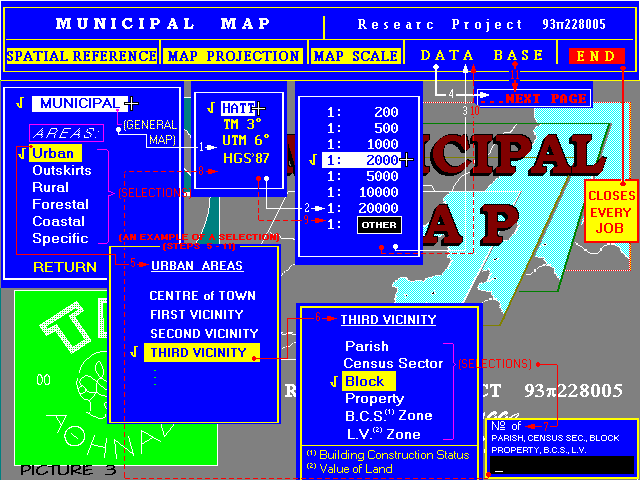
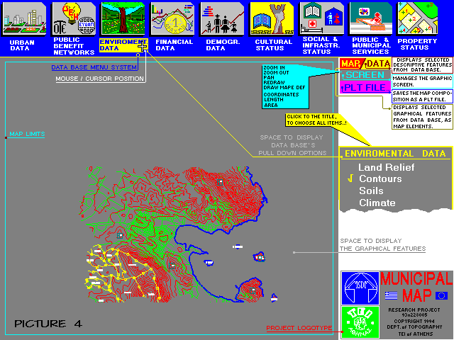
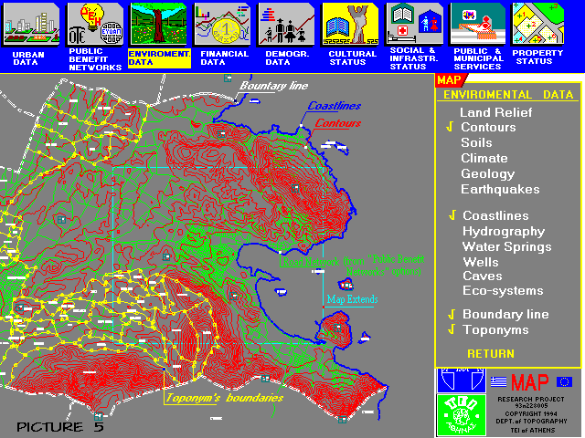
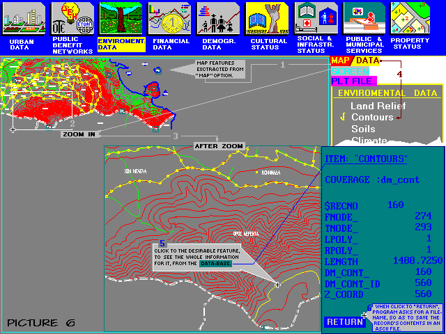
Using the general entities of the geographical database and the above

requirements, the data layers identified for the project are mentioned as

follows:

Coverage                                            Feature Class

Center of the town                          Polygon  -  Line

Vicinities                                  Polygon  -  Line

Outskirts areas                             Polygon

Rural areas                                 Polygon  -  Line

Forestall areas                             Polygon

Coastal areas                               Polygon  -  Line

Specific areas                              Polygon

Parishes                                    Polygon  -  Line

Census sectors                              Polygon  -  Line

Building Construction Status Zone           Polygon  -  Line

Land Value Zone                             Polygon  -  Line

Blocks                                      Polygon  -  Line  -  Point

Land Properties                             Polygon  -  Line  -  Point

Buildings                                   Polygon

Buildings Boundary Lines                    Polygon  -  Line

Cooperatives Properties                     Polygon  -  Line  -  Point

Church Lands                                Polygon  -  Line  -  Point

Big Estates                                 Polygon  -  Line  -  Point

Holdings                                    Polygon  -  Line  -  Point

Parcels                                     Polygon  -  Line  -  Point

Public Lands                                Polygon  -  Line  -  Point

Land Relief                                 Line  -  Point

Contours                                    Line

Soils                                       Polygon  -  Line

Geology                                     Polygon  -  Line

Climate                                     Line

Earthquakes                                 Point

Coastlines                                  Line

Rivers                                      Line

Dried-up streams                            Line

Gullies                                     Line

Water Springs                               Point

Wells                                       Point

Caves                                       Polygon  -  Line  -  Point

Natural Systems                             Polygon  -  Line

Municipality Boundary Lines                 Line

Toponyms                                    Polygon  -  Line  -  Point

Road Network                                Line  -  Point

Railways Network                            Line  -  Point

Coastal Lines                               Line  -  Point

Garbage Collection Network                  Line  -  Point

Power Grid                                  Line  -  Point

Main                                        Line  -  Point

Water Supply                                Line  -  Point

Sewerage                                    Line  -  Point

Telecommunication Network                   Line  -  Point

Municipality Lighting                       Line  -  Point

National's Triangle Network Locations       Point

Nursery Schools                             Polygon  -  Point

Primary Education                           Polygon  -  Point

Secondary Education                         Polygon  -  Point

Higher Education                            Polygon  -  Point

Hospitals                                   Polygon  -  Point

Clinics                                     Polygon  -  Point

Firsti-aid Stations                         Polygon  -  Point

Health Centers                              Polygon  -  Point

Community Clinics                           Polygon  -  Point

Old-people Homes                            Polygon  -  Point

Churches - Monasteries                      Point

Monuments                                   Point

Archaeological Sites                        Polygon  -  Point

Museums                                     Point

Associations                                Point

Libraries                                   Point

Cultural Centers                            Point

Cinemas                                     Point

Theaters                                    Point

Special Interested Buildings                Polygon  -  Point

Munic. Campings                             Polygon  -  Point

Munic. Parkings                             Polygon  -  Point

Munic. Amusement grounds                    Polygon  -  Point

Munic. Cemiteries                           Polygon  -  Point

Munic. Taxes' Zones                         Polygon  -  Point

Munic. Police Activities Sectors            Polygon  -  Point

Banks                                       Point

Town Hall                                   Polygon  -  Point

Telecommunications Offices                  Point

Power Service Offices                       Point

Water Supply Service Offices                Point

Post Offices                                Point

Telephone Boxes                             Point

Public-pillar Boxes                         Point

Public Garbage-cans                         Point

Public Urinals                              Point

Rural Lands                                 Polygon  -  Line

Grasslands                                  Polygon  -  Line

Waterlands                                  Polygon  -  Line

Redistribution Lands                        Polygon  -  Line

Irrigated Lands                             Polygon  -  Line

Arable Lands                                Polygon  -  Line

Horticultural Lands                         Polygon  -  Line

Arboriculture Lands                         Polygon  -  Line

Fallow Lands                                Polygon  -  Line

Forestall Amusement areas                   Polygon  -  Line

Forestall Roads                             Line

Fire-cover Zones                            Polygon  -  Line

Kind of forestall trees                     Polygon  -  Point

Stock Units                                 Polygon  -  Line  -  Point

Kind of animal per Unit                     Point

Fishing Zones                               Polygon  -  Line

Number of Fishing Boats per Zone            Point

Shell Cultivation Zones                     Polygon  -  Line

Industrial Zones                            Polygon  -  Point

Location of Raw Materials                   Polygon  -  Point

Handicrafts                                 Polygon  -  Point

Buildings under construction                Point

Buildings' Extensions                       Polygon  -  Point

Buildings' Demolition                       Polygon

Mining Zones                                Polygon  -  Line

Tourist Zones                               Polygon  -  Line

Hotels                                      Polygon  -  Point

Rooms to Let                                Polygon  -  Point

Campings                                    Polygon  -  Point

Wholesale Trade                             Polygon  -  Point

Retail Selling                              Polygon  -  Point


The pictures bellow represent samples of views appeared when "Municipal

Map" is running.
REFERENCES

Burrough P.A. Principles of Geographical Information Systems for Land

Resources Assessment. Oxford University Press, Oxford 1987.

Libieratos E. Cartography and Introduction to Thematical Compositions.

Zitis, Thessaloniki 1988.

Maniatis I. Formation of an integrate Cadastral Information System for

Greece. Aristotle University of Thessaloniki, Thessaloniki 1985.

Parashakis I., Papadopoulou M., Patias P. Automated Cartography. Zitis,

Thessaloniki 1990.

Tsenes E., Tsagaratos S.,Spanos L. Project for development of the

Municipality of Markopoulo of Attika's Prefecture. Ministry of Planning and

Public Works. 1991

Understanding G.I.S. The ArcInfo method. Esri, Redlands 1990.