 Carolyn Syms Luna, William P. Egetter
Disclaimer: Portions of this paper do not represent adopted policy of the County of Riverside, Board of Supervisors, or the Transportation and Land Management Agency and represents only the opinion of the authors. April 5,1995
The County of Riverside has developed a parcel based Geographic Information System over the last eight years. This system, a multi-department GIS, is managed by the Transportation and Land Management Agency. This paper discusses the approach that the County has used to perform environmental monitoring and develop standards for biological surveys so that policy decisions can be made for development related projects using the parcel base. This paper discusses a variety of issues that were examined to develop the necessary applications with specific emphasis on Federally listed endangered and threatened species, AMLs and procedures to present the information in a comprehensible format to a variety of users with differing areas of expertise. The problems encountered in developing the standards and the ongoing process the County is using to refine that process is discussed. Actual and potential problems with using environmental data gathered at certain levels of accuracy when applied against the parcel base are discussed as well as some future directions the County will be taking to further refine its environmental and related policy making applications.
Riverside County was established in 1893. One of the larger counties in the United States, it covers an area of approximately 7300 square miles containing over 586,000 assessed parcels. During the past ten years the area has experienced extreme rates of growth. The GIS system is one of the systems implemented by the county in an attempt to keep up with the rapid growth experienced within this area. In October of 1992, the County completed the conversion of the unincorporated parcel base within the County and linked it to the County Assessors Tax roll.
The County through its efforts over the past 6 years to protect the Stephens Kangaroo Rat (SKR), listed as an federally endangered species in 1988, has become a recognized leader in the efforts to protect endangered species. Through these efforts, the GIS has provided information and a variety of maps and products designed to designate potential impacts of endangered species on parcels of land within the county. In December of 1993, a GIS Agreement for data sharing was developed and adopted between the U.S. Fish and Wildlife Service (USFWS) - Carlsbad Office and the County to provide for transfers of GIS information between the Service and the County. This agreement was most recently used to provide the Service with parcels and SKR information so they could determine the effects of allowing disking for weed abatement of properties to protect against wild land fires.
Due to the geographic size of the county and the number of cities within the county it has two regional councils of government. Both COG's; Western Riverside Council of Government(WRCOG) and Coachella Valley Association of Governments (CVAG) are engaged in some phase of multi-species habitat development.
In response to the March 25, 1993 federal listing of the coastal California Gnatcatcher (Polioptila californica) as a "threatened" species, the WRCOG, the Riverside County Habitat Conservation Agency (RCHCA) and the Riverside County Regional Parks and Open Space District (RCRPOSD) commissioned Phase I of a multi-species habitat conservation plan (MSHCP). Phase I has just been completed and released that covers approximately 1,320,131 acres within the WRCOG region. Phase I of this program was designed to gather and organize existing information on current and future land uses, generate new information where gaps exist, and develop tools to evaluate potential alternative Coastal Sage Scrub/California Gnatcatcher reserve designs.
The development and focus of this study has been hindered by the logistics of having several governmental agencies involved in the development of the plan. During the very early phases of the process agencies and groups not involved with the County GIS efforts made incorrect assumptions concerning the availability of data from the county, funding requirements, and staff resources within the County. This resulted in delays and other problems that needed to be resolved before data could be delivered to consultants. Funding issues have also delayed progress on this plan. One major deliverable that has been received from this project is an updated vegetation map for western riverside county. Due to funding constraints any additional work in the WRCOG multi- species arena is not envisioned at this time.
Additionally, CVAG is in the process of developing a Memorandum of Understanding (MOU) between its member jurisdictions and appropriate Federal and State resources agencies outlining the conditions and terms for embarking upon a multi-species effort in the eastern portion of Riverside County. As with WRCOG's multi-species effort, capturing reliable funding sources is critical to the success of developing an effective MSHCP. Recently, with some seed monies from a variety of sources, spring biological surveys for a variety of plant and animal species are being conducted. Based on our previously referenced WRCOG MSHCP experience, the County's GIS created base maps for the field biologists to utilize during their surveying, in lieu of having the biological community rely on a variety of sources to use as base maps. As to whether or not the level of resources that are be needed from the County to complete an acceptable MSHCP in the eastern portion of Riverside County are questionable due to existing County budget and funding problems.
In an effort to streamline the time that it took for the public sector to commission a biological survey, the County of Riverside revised its biological survey reporting standards in early 1990. Most notable in this revision was that the 3 party contact provision was dropped. However, a MOU with the County is one of the requirements that needs to be satisfied before a biological survey report can be considered by County staff.
It is unclear as to whether or not earlier streamlining efforts have resulted in biological survey reports containing mapping inconsistencies. Nonetheless, some of the mapping inconsistencies that have been noted by County staff when reviewing general and focused biological survey reports submitted to the County are:
It is not uncommon to find that the property identified in the biological survey is not the same piece of property that the development permit is sought after.
Additionally, some biological survey reports identify inaccurate terrain. This error is quickly detectable since in most of these cases the terrain of the parcel that was surveyed for does not match the correct ground conditions. However, this is generally not the case where a focused field survey is being performed for a Federally listed "endangered" or "threatened" species by a biologist in possession of the requisite federal and state permits necessary to conduct the survey.
Due to the County's fiscal constraints staff reductions have occurred in those areas of County government that are fee supportive therefore impacting departments that serve the development industry. The majority of biological reports are accepted at the TLMA Public Information counters. In an effort to continue to provide acceptable levels of service to the public, a checklist summary sheet was recently developed for the biologist to complete and attach to his/her biological report. The summary sheet essentially enables County staff to quickly evaluate what course of action needs to be taken in order to further process any accompanying permits that are contingent upon receipt of the biological report. Additionally, specific mapping criteria of the subject property is also required to accompany the survey summary sheet.
The survey summary sheet accomplishes two purposes:
Provides a vehicle to a fiscally strained County to maintain acceptable customer service levels; and,
Secures biological data and incidental information that is parcel based for eventual inclusion into the County's GIS.
Biological reports are now being received with this new format. When staff resources and funding become available it is our intention to transcribe these reports into the system within specific biological reporting layers. The County is continuing to discuss how the biological reports and formats can be modified so that critical information can clearly be identified. The County is presently in the process of acquiring PC notebooks with GPS PCMCIA cards for a GIS Traffic Accident analysis and location project. Once these systems are obtained it is our hope a system can be developed that will address the environmental concerns that can be used in the field to address these issues. We are particularly interested in handling the following items:
Identification of the parcel boundaries, streets intersections and the general location of the property.
Identification of areas surveyed or transects walked on the parcel.
Development of polygons, arcs, and points with geocoding to identify biological resources.
Creation of an electronic file that can be submitted to the County with the report that will be ready for inclusion within the GIS system.
The County also functions in a development role in providing new infrastructure or upgrading existing roads and facilities. It is the County intention to first require these enhanced biological surveys on public works projects undertaken by the County. For many projects the County is required to obtain environmental clearances, have biological surveys performed, monitor conditions and provide mitigation. By having more precise biological surveys, recordation procedures and reporting standards the County believes that costs for environmental issues on these public works projects can be reduced.
All data layers are managed with ArcInfo Librarian within the County's GIS system. It has been very difficult for the county to acquire accurate layers of information representing environmental concerns. Presently the County is actively tracking three major species through the GIS. These include the Fringe Toed Lizard, Stephens Kangaroo Rat and the Gnatcatcher. Additional layers are being developed as time permits but these are presently the only ones available for reporting the public information counters. These environmental layers are presently handled through three basic methods.
The first method involves polygons representing the actual preserve areas that have been developed to protect the species. Usually there is another layer associated with the actual preserve that represents a fee area boundary. These fees are collected on development and serve to either expand or maintain the preserves. The first method is represented by the Fringe Toed Lizard and when used with the parcel base provides a definitive method of determining both actual parcels representing preserves and the area associated with fee collections.
The second method involves a fee boundary, study areas and areas of potential habitat that are all handled through polygons. These three layers are used to determine what fees and studies will be required on any particular parcel. The County has had considerable problems with the development and implementation of this method. The fee boundary covers approximately 915 square miles in Western Riverside County and was not defined to parcel boundaries, sections or township lines. However, the SKR study areas were developed by identifying parcel boundaries when the polygon layer was developed. Major problems in rectification, positioning and accuracy were encountered in the conversion of the historical habitat when we received the information from a consultant who was working for the County. Originally developed on a PC based ArcInfo system it was necessary to develop methods to adjust this data so that coordinates were properly established and the data matched the county's parcel base to make the process and data user friendly while complying with the implementation agreement.
The third method uses a vegetation layer to determine areas by habitat type that may be occupied by the California Gnatcatcher. Since California Gnatcatchers, a federally listed "threatened" species protected under the provisions of the Endangered Species Act, are obligate residents of Coastal Sage Scrub habitats, the vegetation layer is used to identify as to whether or not coastal sage scrub habitat is located on a parcel in question. Additionally, elevation is factored in with respect to this bird species. In the WRCOG's MSHCP Phase I study is was reported that; "The overall analysis of elevation indicates that California Gnatcatchers ar found at elevations below 2,500 feet and this finding is consistent with Atwood and Bolsinger (1992)." County staff can confirm that this is the case based on biological surveys submitted to the County for review.
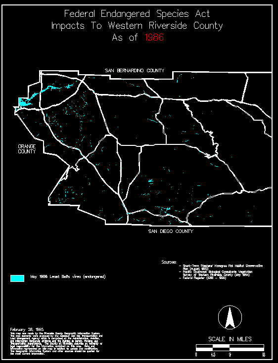
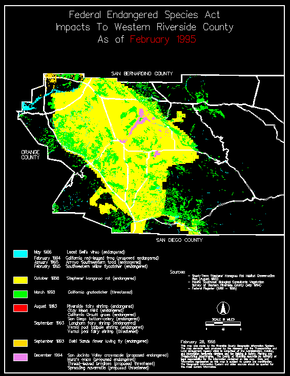
The preceeding maps were developed from the environmental data layers. These maps were recently used to demonstrated the impact of the Endangered Species Act to Western Riverside County over the past ten years.
In combination with the development of the environmental layers it was necessary to develop applications that utilized these layers. The first efforts focus on developing a series of maps concerning the SKR study areas and fee boundary. The fees are used by the Riverside County Habit Conservation Association (RCHCA) a joint powers authority to acquire land for the development of a conservation plan for the SKR and prepare a multiple species habit conservation plan. These GIS maps are used by the RCHCA for its planning efforts and by TLMA for its public information counters. These maps are also sold over the public information counters to interested individuals in both color and blue line reproductions at cost. The GIS maps are used as the major exhibits for the SKR long term conservation plan that should be completed by this summer.
Application development has occurred over the past 2 years through the development of maps and the release of several different version of APN_INFO/PARCEL_INFO. This application provides a method of information retrieval through the Agencies GIS based on a Assessors Parcel Number, Address, Owners Name, Legal Description and by graphically pointing to a area or parcel. The application then returns a list of approximately 45 attributes developed from data bases and layers within the library that is used for research and at the public information counters. We are currently estimating that it is saving the Agency approximately $150,000 to $200,000 per year in staff time. This application is more extensively described in another paper " IN A PUBLIC INFORMATION ENVIRONMENT DATABASE MAINTENANCE AND QUERYING" presented at this conference by Mark Lopez and Don Duncan.
The Endangered Species Act is of course implemented and enforced by the United States Fish and Wildlife Service. However, while the service selects and lists the endangered species it is left up the County or City using whatever tools, knowledge or procedures they can develop to interpret and implement the act for their organization and the property owner. In this unfunded mandate, the majority of the costs for implementation have been placed upon the local jurisdictions and has resulted in different methods of implementation even within the same region. Acquiring the appropriate environmental clearances from the Service for projects has been difficult for the County to acquire an we suspect would be very difficult for the individual property owner to work their way through the process. The major developers and engineers are usually aware of the problems they must address to conform with the Endangered Species Act. However, this is not the case for the small contractor or individual. There has been several occurrences of abuse and threats towards county staff as they attempt to describe the process and procedures the individual must follow to comply with the Endangered Species Act.
With the Parcel_Info application any individual, engineer or developer that is interested in developing a parcel can go to any TLMA public counter and inquire on parcel specific information. The major environmental constraints that may be present on the parcel they have plans to develop can very quickly be identified. This method of using the GIS to provide parcel based information directly to the public provides a consistent methodology for the application and interpretation of the requirements for these endangered species in the entire unincorporated areas of the County of Riverside.
As the number of proposed listings of endangered and threatened species continues to grow especially in California, the Republican Congress is now taking aim at the Endangered Species Act (ESA). The ESA is up for reauthorization and congressional members are hearing their constituents more loudly than ever about the economic impacts to land development and the timber industry, pressures imposed on agricultural activities and questioning the listing process itself. On December 15, 1994, The United States Fish and Wildlife Service (USFWS) published a proposed rule to list Four Southwestern California Plants as Threatened or Endangered. This proposed rule prompted the County Board of Supervisors to very seriously consider terminating County participation in any aspect of ESA compliance and implementation because of frustration with enforcement of the act. This consideration prompted both a public hearing on the listing as well as the recent appearance of a contingent of USFWS officials headed by Mollie Beattie, Director of the (USFWS) at a County Board of Supervisors meeting. The Secretary of the Department of the Interior also recently selected a site in Western Riverside County to announce his "Ten Principles For Federal Endangered Species Act Policy" to the nation.
The County recently has adopted legislative policy as it pertains to the Endangered Species Act (ESA) Reauthorization. A summary of the 10 points are as follows:
Provide for comprehensive habitat based conservation plans, whereby landowners, local governments and others can be assured that land use activities will not be disrupted and additional conservation actions will not be required regardless of subsequent species listings.
Require proposals for listing of species as endangered or threatened be supported by specific types of biological data meeting minimum scientific standards.
Provide a definition of "species" which ensures that: 1) species are taxonomically distinct, and; 2) protection is not afforded to individual population segments of species whose overall populations are not considered at risk.
Modify the definition of "take" to: 1) apply to affirmative attempts to injure, harm or kill a listed species directly, and; 2) exclude destruction or adverse modification of habitat determined by a qualified biologist to be unsuitable for a occupation by a listed species regardless of season.
Provide categorical exemption for routine maintenance and emergency repair of public facilities and infrastructure.
Provide an exemption for new projects crucial to public health and safety when predetermined reasonable mitigation has been established.
Require processing and review of permit applications, habitat conservation plans, and Section 7 consultations to be subject to specific dates of completion and deemed approved if not completed as required.
Require an analysis of the economic impacts of a species listing.
Provide federal financial assistance to assist in the development and implementation of local habitat conservation plans.
Require consultation with affected local jurisdictions prior to a notice of a proposed listing appearing in the Federal Register.
The County intends to continue to work towards redefining the standards for submission of biological surveys that will ultimately result in the submission of an file that will be suitable for inclusion within the GIS as part of the development review process. These standards will require the use of GPS systems to locate parcel boundaries, fixed objects and areas of biological concern for endangered species. Polygons, arcs or points will be geocoded based on standards developed by the County for inclusion within the GIS as part of the biological review process.
Efforts are now underway through discussions to develop a biological pre-review, review and peer review process with the Biological Resources Information Unit ("BRIU") as part of the Urban and Environmental Outreach Program, for University of California, Riverside (UCR). These discussions are being carried out by a committee composed of University staff, Environmentalists, Developers/Engineers and County staff. Impacts on processing, costs and acceptance by the development community must be resolved along with procedures to transfer information from the County and UCR systems must be developed before this new biological review process can be implemented.
The WRCOG and CVAG MSHCP efforts mentioned earlier, ultimately impact the unincorporated parts of the County for the following reasons. Cities don't have large landholdings within their jurisdictions that are vacant and undisturbed. If they do, the parcel is probably an island in a sea of high density residential development or commercial ventures. The likelihood that the parcel has multi-species value is further reduced by the lack of connectivity to other parcels having similar vegetation categories or types. Therefore, the unincorporated lands in the County are generally the lands slated for preservation, since the natural resources are still relatively intact and in a configuration that affords the natural resources protection from encroachment of a disturbing nature. Additionally, the patterns of ownership in the unincorporated County lands are such that large swaths of land can still be found under one ownership. Therefore, there are less parties to work with. The present state of fiscal uncertainty that Federal, State, County and local governmental have to contend with only further challenges us in this arena. The fiscal ramifications to the "Unincorporated County" in the development of a MSHCP needs to be clearly evaluated. Member cities in the two COG's need to evaluate the benefits that they will be accruing under a MSHCP at the County's expense and formulate a palatable partnership of cost/benefit sharing. As a result these plans and studies will reviewed very carefully by the County and the Board of Supervisors who will ultimately make the decision on any course of action the County chooses to take in the implementation of a plan that addresses unincorporated areas and endangered species.
One of the major problems encountered in these efforts has been in the acquisition and validation of information regarding the location of endangered species. The recent efforts by the Service to list new species resulted in a great deal of frustration at the local level. While we were attempting to address the concerns of property owners and developers and work towards protecting species and developing multispecies habitat conservation plans a great deal of credibility on these efforts was lost with the process used on this attempted listing. To reduce or eliminate some of these problems at the local levels we propose the following:
Regional/County systems be provided with GIS endangered species layers for any species listed or proposed to be listed accurate to the parcel base. These layers would be then used to determine what further biological surveys would need to be performed prior to any development of a particular parcel.
Local property based GIS Systems be used to notify all concerned organizations, agencies, and property owners of any impending proposed listing of new species including the scheduling and notification of hearings. Full reimbursement of local costs for notification by the Federal Agencies would be required so that this did not become a unfunded mandate.
Analysis and documentation of actual impacts of public works facilities construction on actual habitat disturbed and a more careful recognition of existing conditions. Currently many public works projects are being delayed, public safety is jeopardized and project costs are increased due to unnecessary procedures and mitigation requirements. For example; the County recently incurred major mitigation costs for a project where we were replacing a low water crossing (ie a road or strip of pavement over a wash) with a new bridge structure.
Reauthorization of the Endangered Species Act based on the ten policy items as adopted by the Riverside County Board of Supervisors on March 21, 1995.
USFWS needs to provide affected organizations, agencies and property owners with acceptable biological survey protocols prior to the date of the proposed listing.
USFWS during the listing process of a species will issue all applicable federal permits to qualified biologist prior to the date the listing takes affect. Additionally the Service will maintain a list of federally permitted Biologist and provide the list and will as any updates, to any entities affect by the listing.
These recommendations cover several major elements: information, notification, reality, modifications to existing legislation and procedures for implementation. While everyone recognizes that science is never fixed, it is now the time for all of the parties involved in implementing or responding to the Endangered Species Act to reach a compromise. Not every species can be protected and not every development can occur in every location. However, the economic realities, existing land use, parcels, and costs involved in developing new infrastructure, commercial, farming, and housing or the other consideration of holding land for environmental habitats must be analyzed. If a compromise cannot be reached, the opportunity to protect some species, develop multispecies habitat conservation plans, and address environmental concerns will be lost.
County of Riverside GIS, " Data Dictionary Reference", an un-published County of Riverside internal document, last revised on January 17,1995.
The entire GIS Data dictionary is available on diskette and can be obtained upon request in a wordprocessing format and/or ANSI text format by sending a self addressed, stamped mail envelope and a 3 1/2" 1.44MB diskette to the author.
Lopez, Mark and Duncan, Donald " IN A PUBLIC INFORMATION ENVIRONMENT, DATABASE MAINTENANCE AND QUERYING" a paper presented at the Fifteenth Annual Esri User Conference, May 1995.
Press Enterprise article (March 8th,1995) concerning the appearance and comments of Mollie Beattie (Director USF&W ) at the March 7th County Board of Supervisors meeting.
Press Enterprise article (April 1st,1995) concerning the appearance and comments of Bruce Babbitt (Secretary of the Interior) regarding the County's SKR long term plan.
GIS Agreement 93-07-09 as adopted by the USF&W and the County of Riverside Board of Supervisors on 12/14/93.
County of Riverside Board of Supervisors, Agenda Item 3.27 Adopted on 3/21/95 Endangered Species Act Reauthorization Legislative Policy.
Western Riverside County Multi-Species Habitat Conservation Plan, Phase I - INFORMATION COLLECTION AND EVALUATION prepared by Pacific Southwest Biological Services, Inc in association with KTUA and Terra Madre Consultants prepared for Western Riverside County Habitat Consortium. February 1995