ABSTRACT:
The City of Sedona, Arizona, has been slowly developing its GIS (Geographic Information System) since the City's incorporation in 1988. By attending GIS conferences and keeping up-to-date with GIS publications, staff members have noted that little emphasis has been placed on GIS applications in small communities. Indeed, many of the extraordinary GIS applications showcased in conferences and expositions are usually applied to cities or regions that encompass large study areas with seemingly massive amounts of good data and the GIS software, tools, staff and budgets to produce outstanding applications and results. Often this is not possible for small communities where poor or non-existent data, a lack of awareness of the potential of GIS by elected and appointed officials, limited resources, staffing and significant budget constraints can hinder the development of a viable, functioning GIS.
A GIS, however, is as valuable a planning and research tool in a small community such as Sedona, as it is in a larger or more sophisticated study area.
This paper will describe the approach taken by the City of Sedona, with its small one-and-a-half-person staff, to develop and apply its GIS. Approaches taken by the City to attempt to resolve the problems discussed above will be addressed. Emphasis will be placed on the methods used by the City to address such issues as data acquisition, education of public officials on the possibilities of GIS, developing support for the GIS program, funding, current GIS applications and the City's future vision for a comprehensive MIS (Management of Information Systems) Division.
BACKGROUND TO THE CITY OF SEDONA:

The City of Sedona, with an estimated 1995

population of just under 9,000 residents, is

located about 120 miles north of Phoenix and 25

miles south of Flagstaff in north-central Arizona.

Located at the south end of Oak Creek Canyon and

surrounded by National Forest lands, pristine

wilderness areas, and stunning natural red rock

formations and canyons, the City has been and

continues to be a major national and international

tourist destination attracting in excess of 4

million tourists annually, many of whom use Sedona

as an intermediate destination on their way to or

from Grand Canyon National Park.  As a result of

its unique scenery and relatively laid back

lifestyle, the town has continued to expand in

size as it accommodates new residents, new

businesses and its booming tourist industry.


As the community is located partially in both

Yavapai and Coconino Counties it has traditionally

been managed by the county governments located in

Prescott and Flagstaff, respectively.  Due to the

pressures of continuing growth and development,

and genuine concerns for the integrity of Sedona's

fragile natural environment, coupled with the need

to establish a coordinated sewer infrastructure,

the community finally approved a measure to

incorporate as a City and establish a City Council

and staff.


Accordingly, in January, 1988, the City of Sedona

was officially incorporated, an Interim City

Council was appointed, and the process of

establishing a City staff was initiated.  On July

1 of the same year, the City assumed zoning

jurisdiction from the Counties for an area of

approximately 19 square miles, 50% of which is

National Forest lands.


EVOLUTION OF MIS AND GIS IN SEDONA:

The foundation for the City's eventual GIS was

established by a far-sighted member of the Interim

City Council who realized the importance and value

of GIS, and who especially realized the value of

implementing such a program in the development of

a new City structure.  As a result of his efforts

in 1988/1989, the City contracted with Cooper

Aerial Inc. of Phoenix, Arizona, to produce aerial

photographs, topographic maps at 2 foot contour

intervals, and planimetric data useful for the

City's eventual GIS needs. This planimetric data

included such elements as pavement edges, power

lines, street centerline, fire hydrants, 10 foot

contours, building footprints, etc.  At the same

time, a single version of PC ARC/INFO with PC TIN

was purchased as well as an HP DraftPro EXL pen

plotter.


Little progress occurred in the development of a

GIS for the City however, as no trained staff

resources were allocated to the development of the

GIS program.


At this time, the City had purchased a number of

computers (3 in the FY1988/89 budget), that were

generally assigned to secretaries within

departments.  As the number of departments

expanded and staffing levels increased, the number

of computers also grew, so that now in 1995 the

City has 52 computers in use.  An important reason

for this increase is that in January,1992, a new

staff member was hired into a full time GIS

Coordinator position.  His experience with

ArcInfo and computers in general provided a much

needed injection of vitality and direction into

the City's then virtually dormant GIS program.

Within a few months, specific useable layers out

of the 1988 planimetric data had been established,

the GIS Division was reorganized and policies and

procedures for the conversion of data were

established.  Through this time the first GIS maps

were produced, including for example the Sedona

Community Plan Map, Capital Improvement Plan Map

and Official City Street Map.  Perhaps most

importantly, a clear and concise vision for the

future of GIS and MIS in the City was also

drafted, and communicated to the City Manager and

City Council.


Development of a Vision Statement for the City's

MIS and GIS needs had some unanticipated

advantages and disadvantages.  Under the GIS

Coordinator's guidance, and continuing support for

hardware and software acquisition from City

Council, the City staff became increasingly

literate in the use of computers while, and as

noted above, the total number of computers in use

in the City expanded.  Fueled by the need to

perform better to satisfy the ever increasing

needs of the development community and citizens

alike, staff members were allocated their own

computers.  Local networks were established in the

various City office buildings, and computer

literacy, experience and service to the public

increased dramatically.  All this had a cost

however, as working alone, and now promoted to MIS

Coordinator, the majority of time necessary to

devote to MIS related functions, (including MIS

Division administration, PC management and

software update and maintenance, network

administration and maintenance, and development of

the data base and billing system for the

Wastewater Department) hindered the progress in

GIS development.  As a result, the continued

development of the GIS program stagnated, and

little further work was completed in layer

preparation or data development.


The author of this paper is a planner by

profession and educational background.  As such, I

have always appreciated the techniques developed

by Ian McHarg in the late 1960's for overlay

analysis of data as a technique for understanding

and evaluating the potential of a parcel of land

to sustain development.  By laboriously producing

hand-drawn maps, overlaying them together, and

manually identifying the unique attributes of each

component, the author eventually realized that he

was manually doing the work of a computer driven

GIS!  After understanding the potential of our

fledgling PC ARC/INFO system, I successfully

convinced the head of the City's Department of

Community Development, with whom I have been

employed since February 1991, that it would be in

the Community's best long-term interest if we were

to commit the necessary time and effort to develop

and expand our skills in GIS development and

utilization.  Shortly thereafter, I commenced my

own training in ArcInfo through ALRIS (Arizona

Land Resources Information System), a division of

the Arizona State Land Department.  After

completing this training in February, 1994, it has

been possible for me to reduce my planning and

development review responsibilities sufficiently

to spend 50 - 75% of my work week in GIS tasks

(for example, developing layers) and mostly MIS

tasks(developing a comprehensive data base for the

Department of Community Development, as will be

briefly described in the following section).


CURRENT STATUS:

In 1988/89 after incorporation, aerial photographs

and planimetric data useful for the City's

developing GIS system were produced. However,

since 1989, the City has been without a parcel

data layer, which is really the foundation for

further development of our GIS.  In February,

1995, we were finally provided a comprehensive

parcel layer for the entire City through the

generosity and cooperative assistance of Yavapai

County, with whom we work regularly in a local

user's group.


A comprehensive list of the layers that have been

developed, and that will be developed now that we

have accurate and acceptable parcel information,

is available form the author.  Generally, our

existing layers include 2 foot and 10 foot

contours, FEMA 100 year flood plain boundary,

building footprints (1988 and 1992), City

boundary, USFS boundary, major drainages, section

and quarter sections lines, major highways, street

centerlines, parcels (1992), sewer phases, trails,

voting sites and others.  Proposed layers include

archaeological and historical sites, zoning

districts, subdivisions, sewer and other utility

infrastructure, and easements.


While at first glance it may appear that we have

progressed well in our layer development, Figure 1

diagrammatically illustrates the current status of

our GIS layers.  While we may have procured the

majority of our layers (polygon, point, line)

anticipated for the City's needs, considerable

work remains to be accomplished and is continuing

in attaching data to these layers.  In terms of

applications and program development, while we

have not yet developed any turn-key systems, we

are, however, currently capable of producing slope

analyses manually, albeit not yet in our

ultimately desired state of efficiency.
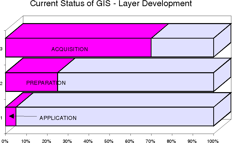
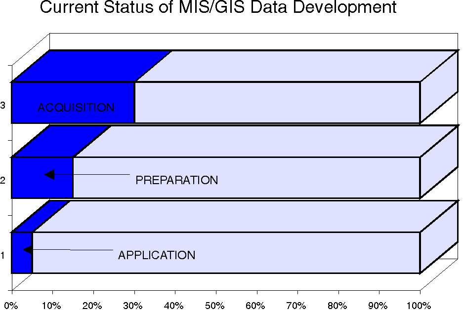
Figure 2 illustrates the current status of MIS/GIS

data development.  This is the area of our

greatest weakness in our GIS program to date, and

considerable work is underway in the development

of data useful for our GIS which can be attached

to existing and proposed layers.  For example, one

of the author's major MIS/GIS responsibilities is

the development of a consistent and uniform

approach to the management, storage, updating and

retrieval of data currently stored throughout the

Department of Community Development in a variety

of mediums (ie. files, maps, computer applications

e.g. Q&A and Excel) and in many different locations

(i.e. individual staff members files or computers,

assorted centrally located files, and anywhere

else we can find to put it).  This will be

possible through the development of a unified

Department Data Base in FoxPro (eventually to

become a City-wide data base) that will be

directly linked to our GIS potential, so that the

data can be readily displayed and analyzed in
 geographical form using ArcView, the desktop GIS

developed by Esri.
Again, in terms of applications and program development, the day to day use of the Wastewater data base represents our best MIS application in use so far. At this time the City has purchased a total of 2 PC ARC/INFO licenses together with PC TIN. In addition, two copies of ArcView 2 have been purchased and are used frequently in both the MIS Division and by myself in the Department of Community Development. PROBLEMS ENCOUNTERED, AND SOME SOLUTIONS EMPLOYED, IN DEVELOPING A GIS FOR THE CITY OF SEDONA: A. Personnel and equipment resources: Problem statement. While the City of Sedona in its relatively short history as an incorporated community has invested substantial monies in data acquisition, hardware and software to make the City's GIS a reality, it has failed to commit the necessary staff resources and training to successfully develop, operate and maintain a viable City GIS. Solution. Sedona's experience, probably not unlike that of other communities, has shown that staffing, with not only qualified individuals, but also enough of them to allow for focussed commitment to system development, is essential to the long term community benefits ultimately available through GIS. As obvious as this may sound, the solution to turning the City's floundering early attempts at a GIS into a fully functioning system came through the hiring of a trained and experienced GIS staff member. Through his efforts, a comprehensive vision statement for the City's GIS was formulated and distributed, data was converted into a useable format and layers developed, and the first GIS maps were produced. This step was critical to the future expansion and development of the City's GIS, because at last some tangible results of the City's investment in the system were produced which were used as examples and "sales tools" for the procurement of additional resources. B. Data issues: Problem statement. While the planimetric data derived in 1988 has been useful for the production of such applications as slope and viewshed analyses, the official City Street Map and general maps such as the Community Plan Map, no parcel cadastral data has been available until very recently. As a result it has been impossible to develop detailed maps showing, for example, land use, subdivisions, land ownership, etc., and of course, no parcel specific applications or queries were developed. Solution. An option we considered to secure parcel data was to 'COGO' the data from known survey information. This would have been a time consuming and expensive process. Fortunately, we learned that the Board of Supervisors for Yavapai County had authorized the expansion of the County's GIS program, and county-wide aerial photography was undertaken in the Spring of 1992. This data has been made available (at no cost) to all communities with GIS systems within the County. We received our final quality controlled data in late February, 1995. Now that the initial start-up problems and "gremlins" have been rectified, yearly updates of the data are planned. Clearly, the City got lucky in its procurement of this accurate no-cost parcel/cadastral data. The lesson learned from this experience though is clear; it is vitally important to maintain open dialogue with higher level government agencies at, for example, the county and state level, as often these agencies with their larger budgets and staff will be able to produce data that small communities are unable to because of budget and staff constraints. C. "It takes so long to get it done!": Problem statement. Yes, it does take a long time to implement a GIS, especially with limited resources, a limited commitment from past senior management and elected officials, and only a one-and-half-person staff to implement it. Technically, the MIS/GIS Coordinator is the full time GIS person (although up until recently MIS responsibilities consumed most of his time) and the author (as a planner with the Department of Community Development) is the half-time GIS person. The length of time it has taken to get just this far in our GIS development has been most frustrating for us, as we can visualize a functioning GIS program, understand its benefit and value, and yet do not have the time nor full resources to make its development occur as quickly as we would like. Such is often the case not only with newly incorporated communities, but often with smaller towns and unincorporated areas with limited budgetary constraints as well. Solution. The Taoist adage that "a journey of a thousand miles begins with a single step" is just as pertinent to new world technology development, as it was to the ancient Emperors of China when first asserted thousands of years ago. Patience and perseverance are essential. It takes a long time to change the minds and habits of people who have operated in a completely different paradigm for years. We have come to accept that if a little bit is done each day towards the full implementation of a GIS for the City of Sedona, then better to gratefully accept a little progress than no progress at all. The perseverance aspect of our approach in Sedona, coupled with a genuine need for an accelerated development program of the GIS as our City expands and application benefits become more apparent, has led us to promote and facilitate work sessions with our City Council, key management personnel and City staff in general. The purpose of these meetings has been to reiterate the past commitment of the City to GIS, to explain its value and benefit by demonstrating some proposed applications that would, for example, help alleviate problems with the City's wastewater system, identify traffic impacts, and determine areas of significant growth. Also, a specific work session was held with the City Council to motivate a case for the expansion of the MIS Division with the author assisting the MIS Coordinator in the position of GIS Analyst, and the appointment of a full-time PC Technician to take care of the City's hardware, software, network and Bulletin Board System needs. These meetings have proven to be invaluable in that they have enabled the Council to "get to grips" with problems in the MIS Division, and to address them in the budget for next year. The important and simple message we have learned is that it is imperative to be both patient and persistent in the initiation and pursuit of constructive, focussed dialogue with decision makers in order to sell the need for GIS and to enlist their support in making it a reality. D. Education of City officials: Problem statement. As the City organization and staff developed and grew, early priorities were not specifically oriented towards the development of the GIS. Staff resources were instead (of necessity for a newly-incorporated community) focussed on developing state-mandated zoning mechanisms and a Community Plan, designing and developing the City wastewater system, etc. Because of this, and a lack of an early focus on the development of the City's GIS and its capabilities, a continuing problem is the lack of understanding by elected and appointed officials, and to a lesser extent now by senior staff members, of what a GIS really is. Too often the perception continues that GIS is an expensive way of making pretty computer generated maps, and the true analytical value of GIS remains misunderstood or altogether unrealized. Solution. Until a clear and concise vision statement for the MIS division was developed and distributed, not much attention to its possibilities for the City's future were considered. Even then with other pressing priorities, it was difficult for the City management to allocate the additional financial resources necessary for the meaningful development of the GIS. A 'grassroots' effort to enlist support from the author's supervisor and that of fellow staff members ultimately helped to promote an awareness of the value of GIS. By distributing articles from GIS magazines, talking about the possibilities of GIS in our real-world context and its potential for saving time and effort in addressing citizen queries, and fostering greater staff efficiency and improved customer service, a sense of curiosity and appreciation for the GIS program was ultimately created. In addition, general presentations were made to the City department heads, to which staff members and elected officials were invited, in order to encourage a new GIS-way of thinking. As a small community with large needs and yet limited resources, we are resigned to the fact that education and promotion of our long range system needs will be an on-going process in order to enhance our community's level of understanding of GIS. Not only is it hard to break old habits, and get staff members thinking in terms of the need for regularly updating and recording data in the data base, but we have learned that the further we continue with the storage of information on paper in files and file cabinets, the longer it will take to "catch-up" as a result of our past habits. With the high volume of work to be done tracking new growth and development, it is absolutely essential to ultimately overcome the perception that new approaches to data management take too much time to learn, and will interfere with a busy work day. The key element we discovered was that it is essential to be persistent in spreading the word about GIS's value, explaining how its use will save time and answer questions and perform tasks in minutes and hours that would have otherwise perhaps taken days or weeks to complete. As we are developing and expanding our data base for eventual attachment to our GIS, some approaches we are using to alleviate this problem include:E. Budget constraints: Problem statement. Financial conditions in America are such that most government organizations these days are faced not only with budget cutbacks and limited financial resources, but also high levels of competition for the use of those public funds, all for commendable and worthwhile projects. This is certainly true of the City of Sedona. Nonetheless, and in spite of a recently imposed State spending limitation, we have been fairly successful in procuring financial support for a more rapid expansion of the MIS Division than occurred in the City's first few years. However, our big dream of a workstation GIS environment may still have to wait a few more years! Solution. We used a number of simple, yet effective, techniques to achieve many of the GIS accomplishments made to date. A few of these are briefly discussed below:
- The use of volunteers from the community to assist with data compilation, sorting and entry.
- Establishment of regularly scheduled mini-meetings with key staff members to review the progress of new projects and record any data updates as necessary, and to remind staff again of the value and benefit of GIS.
- Circulation of the department Data Dictionary so that staff members, even if they just skim through it, will gain at a minimum some additional understanding of the data base and GIS development.
- At regular staff meetings, keep the other department staff members informed of progress, new developments, updates, etc.
F. Dealing with isolation: Problem statement. A small rural community like Sedona is not only geographically isolated from larger communities with established GIS systems, but also at times appears to us to be technically isolated as well, by virtue of the fact that as a user of PC ARC/INFO little literature is available to describe PC-based applications, issues or concerns. Most of the current literature focusses on the extraordinary GIS applications usually applied in cities or regions that encompass large study areas with seemingly massive amounts of good data and the GIS software, tools, staff and budgets to produce outstanding applications and results. Also, we have yet to secure and use additional data lines and get access to the Internet. Solution. We quickly learned that there is considerable value to be gained by reading about the techniques and approaches used by all users of GIS systems world wide. While many applications may not be directly applicable to our small town situation, the fascination of studying successfully applied GIS projects is extremely motivating and has helped us remain focussed on the vision of GIS for the City of Sedona, especially when at times it has not looked too promising. The importance of staying current with new trends and techniques cannot be emphasized enough. It is equally important to be in communication with fellow users at both the state and local levels. As members of both the Arizona ArcInfo User's Group and Yavapai County ArcInfo User's Group, we have benefitted from open friendly discussions with other users. By hosting the summer meeting of the Arizona ArcInfo User's Group in July, 1994, we received significant exposure both locally and in the Esri ARC News Summer/Fall 1994 edition (Volume 16 No. 3, page 41). This provided impressive ammunition in our discussions with City Council members on the development of our GIS. CONCLUSION/VISION FOR THE FUTURE: In this paper the author has tried to show that the City of Sedona has already made a significant commitment to the establishment of a GIS, particularly with regard to the investment in time and financial resources allocated to staff and personnel, the acquisition of hardware and software, and the continued development of our data and layer needs. However, as the preceding discussion has also shown, we still have a long way to go in establishing and realizing the full analytical potential of our GIS. A first step to accomplish this, given that at last we have an accurate parcel layer for the City, will be to finalize the development of our data bases and to attach this data to our GIS layers. This will then become the foundation for our GIS, the platform upon which its future will be built, as we progress with the development of valuable problem-solving applications. Having now as the MIS staff made realistic promises to senior staff members and our elected officials on the capabilities of the City's GIS, it is up to us to prove its value and benefit by producing and applying some GIS applications that will help us to resolve critical issues faced by the City at this time. One such application will be with the Wastewater Division. As noted earlier, one of the prime issues motivating the incorporation of the City was the need to address wastewater disposal in the Sedona area to reduce non-point source pollution in Oak Creek. This has been accomplished in part through the design, development and construction of a wastewater treatment facility operated by the City, with its associated pump stations, sewer lines, etc. The development of the system has not been without its share of problems, however, and financial constraints, legal disputes, construction difficulties due to the prevalence of hard rock in the area and a lack of planning has brought on many delays, complications and lots of general confusion in areas such as billing, hook-up fee collection, etc. A logical application of the City's GIS in this context would include identification of paid and unpaid system users, accurate calculations of estimated and actual flows, and together with an application to monitor and evaluate areas of highest construction activity and growth, the ability to better plan and implement the construction of future phases of the overall system. Other applications that will be implemented as soon as possible include analyses of growth and development within the City relative to housing needs, zoning categories, etc; detailed traffic analysis and modelling; stormwater analysis and planning; fire hydrant and water supply inventory and planning to address concerns for fire safety; and finally applications in forward planning initiatives, such as the West Sedona Highway 89A Corridor Study. Some final comments on our vision for the future of GIS in Sedona. Essentially our goal is to have accurate up-to-date information available to all City users across our local network. In order for this to be accomplished, a number of significant upgrades will be required,including replacement of our existing PC based GIS environment with a workstation system; expansion of our existing network to a Novell configuration to accommodate data transfer between users and a new accounting package; purchase and installation of ArcView 2 for at least each City department (for some departments such as Community Development, additional licenses will be purchased); implementation of a Bulletin Board System so that members of the public can access information from City Hall via modem, thereby hopefully helping to reduce the amount of traffic on City highways; and finally, connection to the Internet to permit global exchange of information and ideas. We have come along way since the first days of our GIS back in the late 1980's, and we still have a long way to go in order to accomplish the real life analytical GIS applications that we strive to produce. However, with the foresight, patience and determination that we gained from our past experience, we are confident that we can accomplish our goals and vision for a viable effective GIS for the City of Sedona. REFERENCES:
- Creative budgeting. While it has the potential to get most Accounting Departments excited, and while legal and financial priorities exist, it is valuable to pursue creativity with adopted budgets to the extent that funds from one account may be internally reallocated to another in order to achieve important goals. For example, the author's attendance at the GIS/LIS Conference in Phoenix last year was made possible by "persuasive bargaining" with fellow staff members who were willing to forego their own program and personal development objectives to support our long term GIS needs. Careful documentation of reallocated budgeted funds is, of course, required.
- We have found that it is important to volunteer the use of personal vehicles for transportation to and from out-of-town training sessions and conferences, because this saves the City money and shows a commitment and willingness by a staff member to contribute to an event that ultimately will significantly benefit that staff member. As an example, when the author completed his ArcInfo training through ALRIS, he used his personal vehicle to travel to Phoenix and stayed with a friend to save on accommodation expenses. It worked, as he would not have otherwise secured the approval to complete this training.
- It is important to be open about GIS, to share knowledge gained from conferences and meetings, and to distribute it to senior staff members and elected officials. We have found that by getting these important decision makers excited by the possibilities of GIS by showing them new products, techniques, etc., then come budget time, we have a greater chance of gaining approval for those exciting new tools and products on our wish lists.
Ian L. McHarg, "Design With Nature" - first published by Natural History Press, Garden City, New York, 1969