Jeff Cargin, John Dwyer
Federal law requires that each state be responsible for ensuring that low-level radioactive waste generated within its borders is disposed of safely. A state may do this individually, or may combine their efforts with other states and form a compact. Pennsylvania, Maryland, West Virginia and Delaware have joined to form the Appalachian Compact, with Pennsylvania agreeing to site the first low-level radioactive waste disposal facility (LLRWDF) for the Compact. The screening process, designed to locate a suitable site for the facility, is now underway. This statewide screening is a time-consuming, rigorous effort, and a Geographic Information System (GIS) has necessarily become an integral part of the process. Screening is divided into two major portions: Disqualification (determining where the facility cannot be located), followed by Evaluation (determining where the facility should be located). This paper will discuss the siting process in general, focusing on the use of the GIS to track data, automate tasks and simplify the overall process. Topics covered include: incorporation of regulations into a spatial database; quality assurance procedures involved in the Project; and involvement of the public in the siting process.
1.0     INTRODUCTION


Federal law requires that each state be responsible for ensuring that the

low-level radioactive waste generated within its borders is disposed of

safely.  A state may do this individually, or combine its efforts with

other states and form a compact.  Pennsylvania, Maryland, West Virginia,

and Delaware have joined to form the Appalachian Compact, with

Pennsylvania agreeing to site the first low-level radioactive waste

disposal facility (LLRWDF) for the Compact.  The screening process,

designed to locate a suitable site for the facility, is now underway.  This

statewide screening is a time-consuming, rigorous effort, and a Geographic

Information System (GIS) has necessarily become an integral part of the

process.  Screening is divided into two major portions: Disqualification

(determining where the facility cannot be located), followed by Evaluation

(determining where the facility should be located).  This paper will

discuss the siting process in general, focusing on the use of GIS to track

data, automate tasks and simplify the overall process. Topics covered

include: incorporation of regulations into a spatial database; quality

assurance procedures involved in the Project; and involvement of the

public in the siting process.


2.0     REGULATORY BASIS FOR THE PROJECT


Fifteen years ago, only three states had disposal facilities for low-level

radioactive waste (LLRW): South Carolina, Nevada, and Washington.  In

order to achieve a more equitable sharing of the responsibility, the

United States Congress passed the Low-Level Radioactive Waste Disposal Act

of 1980 and the Low-Level Radioactive Waste Policy Amendment Act of 1985.

These acts required states to ensure that wastes generated within their

borders were disposed of safely.  The acts also encourage states to form

"compacts" of two or more states sharing a single regional facility.  As

an incentive, a compact can legally exclude outside states from using its

disposal facility.  As a result of this legislation, in 1985 Pennsylvania

joined with Delaware, Maryland, and West Virginia to form the Appalachian

States LLRW Compact under the Appalachian States LLRW Compact Act.


Pennsylvania, as the largest producer of LLRW of the four Compact states,

was selected to host the first LLRW disposal facility.  In 1988, the

Pennsylvania legislature passed the Pennsylvania Low-Level Radioactive

Waste Disposal Act, specifying technical, financial, and policy

requirements.  Regulatory responsibility for implementing the requirements

was granted to the Pennsylvania Department of Environmental Resources

(DER).  The regulations for carrying out the 1988 Act are specified under

25 Pa. Code Chapter 236, effective October 28, 1989.  The DER was

responsible for choosing a contractor to site, design, build, operate, and

decommission the facility.  Chem-Nuclear Systems, Inc., (CNSI) was chosen

as the contractor. Law Environmental, Inc., (LAW) was subsequently chosen

as prime subcontractor to CNSI for siting the facility.


The process for siting and licensing the facility is divided into two

phases.  In Phase I (Screening), the entire Commonwealth is screened to

find three potentially suitable sites.  These three potentially suitable

sites are then submitted to the Pennsylvania Environmental Quality Board

(EQB); upon determination by the EQB that these three sites are among the

best in the Commonwealth, the Phase II siting begins.  Phase II involves

detailed site-specific characterization to determine which of the three

sites is best suited for the disposal facility, and the submission of a

license application for that site.


As part of the Phase I Screening process CNSI was required to submit a

Siting Plan, detailing the process.  The Siting Plan, approved in August

1991 (Rev. 0; current version is Rev. 2, dated April 1994), divides the

statewide screening process into two parts, Disqualification and

Evaluation. Disqualification was divided into three stages:  state-wide;

regional; and local.  Evaluation too was divided into Evaluation Screening

and Site Selection.  (These various portions of the screening process are

further described below.)  The guidelines provided by DER for producing the

Siting Plan required the use of a GIS in the siting process.  As a result,

GIS, and specifically ArcInfo, has been and will continue to be an

integral part of the entire siting process.


3.0     SITING PROCESS


The overall siting process for the Pennsylvania Low-Level Radioactive Waste

Disposal Facility consists of two phases - Phase I, Screening, and Phase

II, Characterization/Licensing.  The Phase I Screening process consists of

three portions, as shown in Figure 1: Disqualification, Evaluation

Screening, and Site Selection.  These various components are described in

further detail in the following sections.
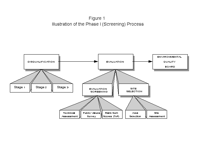
3.1 Disqualification
The disqualification process uses a staged approach to systematically
eliminate areas of the state that are not suitable for siting a low-level
radioactive waste disposal facility. Disqualified features are identified
in the Chapter 236 regulations; these regulations were interpreted for use
in the siting process and a series of disqualifying criterion statements
were developed to reflect the regulations.
During the disqualification phase of the project, a total of 18
disqualification criteria were processed, which involved the application
of 35 individual disqualification data layers (see Table 1). Each data
layer was prepared as an individual GIS coverage in ArcInfo. The
disqualification data layers covered a wide range of size and complexity,
from extremely small coverages such as National Fish Hatcheries (four
polygons and 300 acres disqualified) to extremely large coverages such as
Geologic Stability (nearly 20,000 polygons and 423,000 acres
disqualified), and Exceptional Value Wetlands (5,500 polygons and 9.9
million acres disqualified).
TABLE 1
Application of Disqualifying Criterion Statements
Disqualifying (DQ) Stage Stage Stage
Criterion Statement One Two Three
DQ-01- Masking Facilities X
DQ-02 - Active Faults X x
DQ-03 - Geologic Stability X
DQ-04 - Slope X
DQ-05 - Carbonate Lithology X X,x X,x
DQ-06 - River Floodplains X
DQ-07 - Coastal Floodplains X x x
DQ-08 - Important Wetland X
DQ-09 - Dam Inundation X
DQ-10 - Public Water Supply X
DQ-11 - Surface Water Intake X
DQ-12 - Wildlife Area Boundaries X X,x x
- National Park Systems
- National Forests
- National Wildlife Refuges
- National Fish Hatcheries
- National Wild and Scenic Rivers
- PA Wild and Scenic Rivers
- National Wilderness Preservation Systems
- PA Natural and Wild Areas
DQ-13 - State Forests and Game Lands X x x
- State Forests
- State Game Lands
DQ-14 - Watersheds X x x
DQ-15 - Oil and Gas Areas X X,x X,x
- Gas Storage Areas
- Oil and Gas Fields
- Oil and Gas Wells
DQ-16 - Agricultural Land X
- Agricultural Security Areas
- Class I Soils
DQ-17 - Mines X X,x
DQ-18 - Protected Area Boundaries X X,x X,x
- National Natural Landmarks
- National System of Trails
- National Register of Historic Places
- State Park Systems
- County Park Systems
- Municipal Park Systems
- Historical and Museum Commission Lands
X - Denotes Stage where criterion was first applied
x - Denotes that previously applied criteria are re-applied
Early in the process it was apparent that the GIS could be used to
significantly increase the efficiency in which the DQ criteria were
applied. Disqualification was applied in a three stage process, with
Stage One being applied at a statewide scale (1:250,000), Stage Two at a
regional scale (1:50,000), and Stage Three at a local scale (1:24,000).
The staged approach was used to apply criteria that removed large areas at
an early stage in the process. Once an area is disqualified by one
criterion, there is no need to look any further in those areas for any
other disqualifying features. By applying large, statewide disqualifiers
at Stage One and Stage Two, the GIS could be used to prepare plots of
disqualified areas, which were then used to reduce the level of effort
required for delineation and digitizing of disqualified features during
Stage Three.
The Stage Three coverages posed a special challenge for coverage
development. Many of the individual coverages were so large that
combining all of the digitized files into a single data layer coverage
required a significant effort. An even more difficult task was combining
all of the individual data layer coverages into a single composite
statewide coverage. As individual coverages were combined, the size of
this coverage grew so large that it reached a point were it was not
feasible to work with without dissolving. Therefore, as each individual
coverage was added into the composite, it was dissolved to reduce it to
the smallest size possible. Even with this technique, however, the size
of the final Stage Three disqualification coverage was well over 100 MB,
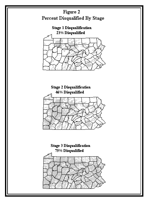
with a total of over 100,000 polygons. The disqualification process
eliminated approximately 75 percent of the state from consideration as
potential disposal facility site. Figure 2 illustrates the area and
percent disqualified for each of the three disqualification stages.
3.2 Evaluation Screening and Site Selection
The Evaluation portion of Phase I Screening consists of two parts;
Evaluation Screening and Site Selection. In Evaluation Screening, the
remaining non-disqualified portions of the state are screened as to their
favorability for siting the proposed facility. A series of 14 additional
criteria are currently being applied, each of which designates an area as
either more favorable or less favorable for licensing. The process then
combines these technical scores (T) with a public values survey to factor
in public rankings (P) and develop an overall rank-sum index score for each
area, with the top 50-100 areas moving forward into Site Selection. This
process, know as the TxP process, ensures that public input is included in
the final determination of potential sites.
The evaluation screening criteria are categorized into groups known as
Major Factor Groups (MFG). There are a total of nine Major Factor Groups,
each containing one or more individual criterion statements, as shown in
Table 2. Three of the MFGs - Geology, Surface Water Features, and Water
Supplies - have been designated as Key MFGs for Evaluation Screening.
This designation indicates that an area must score favorably for each
individual criterion within the Key MFGs in order to be considered as a
potentially suitable site and move forward in the process. The public
rankings of the Key MFGs will still determine an area's overall rank-sum
index score, but any areas which receive a less favorable score during the
technical assessments for any one of the Key MFGs will be deferred from
consideration prior to applying the public rankings.
TABLE 2
Evaluation Criterion Statements Sorted By Major Factor Group
Evaluation Screening Site Selection
Criterion Statement Criterion Statement
Land Use
SR-02 Federal/State SL-01 Masking Facilities
Prison Lands SL-02 Conditions of Ownership
SR-03 Public Gathering SL-03 Planning and Zoning
Places SL-04 Safety Services
SL-05 Utilities
SL-06 Economic Conditions
SL-23 Public Gathering Place Impacts
Transportation Effects
SR-07 Road Hazards SL-07 Connecting Road Condition
SL-08 Connecting Road/Bridges
SL-09 Safety of Roads
SL-10 Distance Along Connecting Roads
SL-24 Potential Transportation Hazards
SL-25 Residential Dwellings
SL-26 Public Facilities
Weather
SR-08 Severe Weather SL-27 Severe Weather Conditions
Conditions
Geology *
SR-09 Tectonic Framework SL-11 Capable Faults
SR-10 Carbonate Lithology SL-12 Proximity to Epicenters
SL-13 Geomorphology
SL-14 Geologic Evaluation
SL-15 Soil Conditions
SL-28 Tectonic & Geologic Structure
SL-35 Exploration & Exploitation
Surface Water Features *
SR-12 Erosion SL-16 Surface Hydrology
SR-13 Surface Water SL-17 Storm Events
Features SL-29 Upstream Modification
SL-30 Erosional Processes
Water Supplies
SR-14 Groundwater Table SL-18 Surrounding Water Supplies
SR-16 Surface Water SL-31 Depth to Groundwater Table
Features SL-32 Aquifers
SL-33 Adjacent State Boundary
Wildlife
SR-17 Wildlife Area Bnd's SL-19 Federally Protected Species & Habitats
SR-18 Watersheds SL-20 PA Protected Species & Habitats
SL-34 Watershed Impacts
Natural Resources
SR-21 Mapped Natural SL-21 Commonwealth Resources
Resources
Cultural Resources
SR-20 Protected Area SL-22 Geologic Features
Boundaries
* Denotes a Key Major Factor Group
The GIS plays an integral role in the application of Evaluation Screening.
Many of the individual screening criterion statements involve buffering
coverages to identify less favorable areas. For example, it is less
favorable to be within one mile of a Wildlife Area Boundary. Since
Wildlife Area Boundaries were previously identified during the
Disqualification phase, applying this screening criterion becomes a simple
task of buffering an existing coverage by one mile. Other criteria,
however, such as Road Hazards, present a much more difficult challenge.
The Road Hazards evaluation involves investigating each
non-disqualified/non-deferred area to determine if it is possible to
travel from the nearest limited access highway to the area without passing
through four intersections in any given one-mile segment. Given the fact
that this evaluation must occur on a statewide basis, and that there are
over 1,500 possible exit points from the limited access highway system,
this quickly becomes a monumental task. ArcInfo's networking
capabilities are being utilized to automate this analysis to the extent
possible to minimize the amount of manual effort involved.
The GIS is also perfectly suited for applying the TxP process. Once
individual screening data layer coverages have been completed and combined
with the previously disqualified areas, each non- disqualified polygon
that has passed the Key Major Factor Group analysis will have an item in
the polygon attribute table reflecting the technical score from each of
the 14 evaluation screening criteria. From there it is a simple task to
assign the public rankings to each polygon and develop an overall rank sum
index score. Following this step, a bottom-up iterative process will be
initiated to identify a threshold rank-sum score that will result in the
selection of approximately 50- 100 highest scoring areas to move forward
into Site Selection. However, simply selecting areas on the basis of the
overall rank-sum score may result in the selection of very small areas.
Since there are minimum area requirements for the site (for example, the
site must be approximately 500 acres), each area selected must be checked
to determine if these area requirements are met. Once again, the GIS can
be used to completely automate this process and remove the need for manual
evaluation. Using this method, the highest scoring 50-100 areas which meet
the minimum area requirements will be moved forward into the Site
Selection phase of the project.
In Site Selection, the remaining criteria are used to narrow consideration
from the 50-100 areas introduced from Evaluation Screening to a subset
from which three potentially suitable sites are chosen to be submitted to
the EQB. While the details of the Site Selection process are still being
developed, in general the first portion of the process involves the
application of certain evaluative criteria as more or less favorable, in a
manner similar to that of Evaluation Screening, in order to narrow the
subset of available areas. This portion of the process will be handled in
the GIS in manner similar to that of Evaluation Screening.
The subsequent portion of the process involves a more intensive gathering
and compilation of data for the remaining areas for use by a Site
Selection Panel, which then selects three potentially suitable sites from
among the candidate areas. This portion of the Site Selection process
uses publicly available information to make a preliminary determination of
whether a site meets the necessary regulatory requirements and performance
objectives. (The final determination is made during Characterization
based on on-site investigations.) The GIS is also an important component
of the Site Selection portion of the siting process. In order for the Site
Selection Panel to make best use of the necessary data (which includes
information on geology, hydrogeology, hydrology, flora and fauna, local
zoning, property ownership, and much more), the GIS team will develop an
ArcView interface, which will allow the Site Selection Panel to examine the
inter-related data sets for a given site, as well as make site-to-site
comparisons.
3.4 Site Characterization
During Site Characterization, detailed studies will be performed on the
three potential sites approved by the EQB in order to determine which of
the three would be the best location to site the facility. Evaluations
performed during characterization include groundwater flow modeling and
geologic evaluations, meteorological and air quality studies, and habitat
and wetland studies. Characterization is planned to be performed over a
time period of at least one year so that seasonal data can be collected at
each of the three potential sites.
Because of the intensive data collection involved in a study of this
nature, the GIS will be an essential tool to be used in the management of
the spatial data collected. It is anticipated that extensive use will be
made of automated data collection devices, such as electronic data loggers
and GPS units. An extensive relational database will be established to
manage the data efficiently and link it to its spatial components in the
GIS.
In order to make the GIS most efficient, it will have to be accessible to
as many people as possible. Applications will be developed, using both
ArcInfo and ArcView, to make the system usable by people who are not
experienced GIS operators. In this manner the system will be available to
site geologists, engineers, and scientists to aid in decision making
throughout the process. The data from each of the three sites will also
be available through a central GIS office to the project management and
administrative personnel to assist in the development of progress reports
and financial statements.
4.0 QUALITY ASSURANCE
On a project of this magnitude, Quality Assurance (QA) procedures are of
the utmost importance. LAW has established an entire series of formal
project procedures which assure that the quality of the work will meet the
high standards set for the project (ASME NQA-1). Many of these procedures
were developed specifically for controlling activities associated with the
GIS, such as backup procedures and digitizing procedures. The following
section will discuss several of the key QA techniques used on the project.
Since most of the spatial data entered into the GIS is digitized manually,
a great deal of effort was put into developing a set of procedures that
could be used to standardize digitizing tasks and allow for efficient
digitizing while still meeting the project's quality standards. Two
digitizing procedures were developed, one for ArcInfo and one for
AutoCAD. At its peak period during Stage Three Disqualification, the
project required a staff of nearly 60 digitizers in 13 different offices
across the United States; the QA procedures ensured that the digital
files received from one digitizer would be identical in format to those
received from another. This, in turn, allowed the GIS staff, using Arc
Macro Language (AML), to automate the process of transferring the digitized
files into ArcInfo coverages and resulted in a substantial time savings
to the project.
While QA procedures provide overall guidance for performing project
activities, task-specific work is controlled through the use of written
work instructions. For digitizing staff, the work instruction references
the appropriate QA procedure(s) and, in addition, identifies any
task-specific instructions required to complete the work, such as the
file-naming convention to be used for a particular data layer.
Once each map has been digitized, a checkplot is produced for each source
map to verify that the digitizing has been completed properly for that
map. Each checkplot must undergo a triple review process before it is
accepted into the GIS. In addition to this review process, the project QA
staff also performs an independent review of each batch of maps being
digitized. This checkplot review process also occurs at each step of the
coverage building process after digitizing, up to and including the
creation of final composite coverages for each stage of the project.
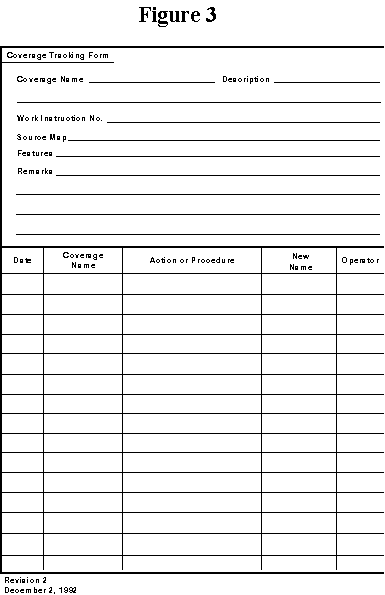
Tracability is essential during the coverage creation process; the QA
procedures provide a method for documenting each step in the process. The
primary tool for providing the documentation is the Coverage Tracking Form
(see Figure 3). This form is used to document each activity associated
with coverage development, beginning with the digitizing process and
continuing through each post-digitizing activity performed on the
coverage. The Coverage Tracking Form indicates the coverage name and
description, the Work Instruction number under which the work is
performed, any pertinent remarks about the coverage, and a specific
listing of each activity performed, including its date and the operator
who performed the work.
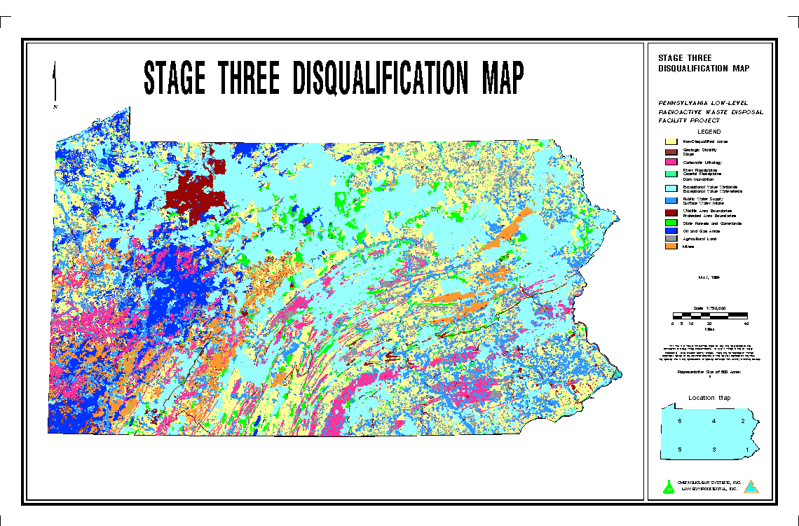
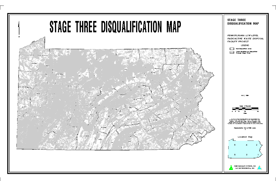
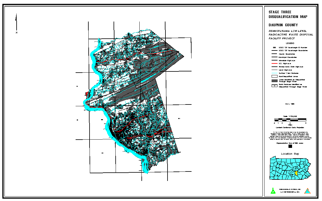
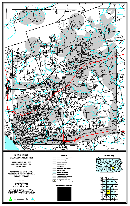
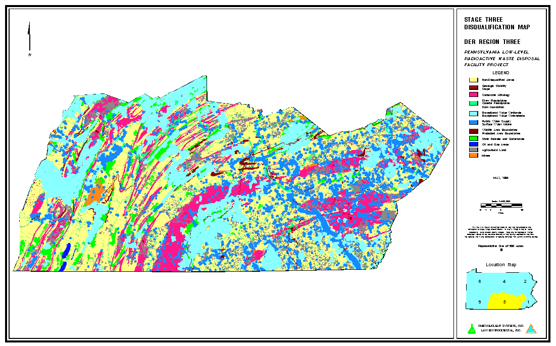
Even with extensive quality assurance procedures, on a project of this

magnitude it is inevitable that errors will occur at some point in the

process which will require that corrective action be performed on a

previously completed coverage.  To address this situation, LAW developed

its Error and Omission (E&O) tracking system.  When an error and/or

omission is discovered, an E&O Tracking Form is completed which documents

the problem and identifies the appropriate corrective action.  The form

also identifies any other coverages that are either directly or indirectly

affected by the error or omission.  The form is placed into the active E&O

file until all necessary corrections have been made to the coverage or

coverages affected by the problem.  Once all corrections have been made,

the E&O form is formally signed off by the appropriate management staff

and quality assurance staff and the E&O is officially closed.  This system

provides an efficient way of tracking errors which in many cases can have

long reaching affects on other coverages and data layers and which may

take some time to resolve.


5.0     PUBLIC INVOLVEMENT


Involvement of the public in the siting process at every possible point is

essential to the overall success of a project such as this.  The GIS has

been a valuable tool in making this public involvement possible.  The

ability to produce hardcopy maps, at varying scales, of the multitude of

features involved in the project has been a key to the successful

dissemination of the project's progress to the public.


At the completion of each phase of the project, a series of public meetings

is held across the state to present the information to concerned

citizens.  To date, public meetings have been held at the completion of

Stage One Disqualification (November, 1991), Stage Two Disqualification

(February, 1993), and, most recently, Stage Three Disqualification (May,

1994).  The Stage Three public meetings involved an extensive map

production effort.  A series of maps were produced which illustrated the

disqualification process at a variety of scales.  On a statewide scale of

1:750,000 each individual disqualification criterion was plotted in a

different color, and, in addition, each was plotted in the same shade of

gray.  Between the two maps the public could visualize what areas of the

state were disqualified and which particular disqualifiers eliminated the

most area in different regions of the state.  The same information was then

produced for each of the six DER regions at a scale of 1:400,000.


Moving to a more localized scale, a 1:150,000 scale series was prepared for

each of the 67 counties in the state.  These maps showed the composite

disqualified areas in gray, but also added local features such as roads,

streams, and USGS 7.5-minute quadrangle boundaries.  These maps allowed

the members of the public to generally locate themselves within a county

and identify which quadrangle they were interested in.  Finally, each of

the 872 quadrangles in the state was prepared at a scale of 1:24,000.

Again, these maps included the disqualified areas in gray, as well as the

roads, streams, and municipal boundaries.  Using these maps, members of the

public were able to locate the precise location in which they were

interested and determine whether or not it had been disqualified.  The

project team received numerous compliments on the clarity and usefulness

of the display maps from members of the public, including those who may

have been opposed to the project in general but still appreciated the

level of effort put forth to present the project information in an

understandable manner.


The project team continues to receive requests for maps even now at a rate

of approximately 15 to 20 maps per week.  It is estimated that over 10,000

original maps have been produced and submitted to various public agencies

and citizens since the completion of Stage Three Disqualification.  This

type of effort could not have been accomplished without the use of a GIS.

By using AML, the project team was able to automate the entire map

production process, allowing plots to be produced around the clock.  This

capability of producing customized maps for release to the public has

proved to be an extremely valuable asset to the project in terms of public

involvement.  Examples of some of the maps prepared for public distribution

are shown in the following figures.
ACKNOWLEDGEMENT


The authors wish to acknowledge the management and staff of Chem-Nuclear

Systems, Inc., for their cooperation and support in the production of this

paper, and throughout the entire GIS siting effort.