 Figure 2.1 Functional Description
Greg Thomas
Responsible watershed management has become the subject of increasing public attention due to a combination of natural events and government legislation. Efficient and accurate stormwater modeling capabilities are necessary to support demands for development while minimizing impacts downstream. Current "semi-automated" procedures for modeling stormwater behavior required tedious and time-consuming data collection, manipulation, and data input preparation activities. Computer-based models present primitive punchcard-like interfaces for entering data and commands and produce volumes of output in non-graphical, tabular report format. Calculating parameters such as drainage area, curve number, and time of concentration can take weeks for a single watershed. This presentation describes application of new computer technology to improve stormwater analysis activities.
This paper will demonstrate application of a suite of stormwater modeling tools that can help engineers conduct analysis in a fraction of the time required using conventional methods. These tools are based upon Geographic Information System (GIS) software and databases. The presentation will include a brief overview of the widely-used models that form the basis of the software suite: TR-55, TR-20 and HEC-2 models. It will include an in-depth examination of the functionality and integration of the models and their enhancement through GIS. The presentation will also describe the GIS database components necessary to support stormwater modeling.
The process of watershed modeling has changed little over the past 25 years. Engineers pour over numerous maps and source documents to collect information regarding terrain, land cover, soil types and stream channel locations for a study area. This information is compiled, organized, encoded then entered into a computer system in terse punch card format. The data is processed through model algorithms which produces reams of tabular reports. These tabular reports are examined by highly trained personnel to interpret results. This process is repeated, adjusting input variables, until the engineer determines that an accurate representation of the watershed and drainage facilities is achieved.
Innovative System Developers, Inc., under the sponsorship of Prince George's County, Maryland, embarked on a project to modernize this process in 1992. This program called for the integration of several independent storm water models into a state-of-the-art computer system based on geographic information system (GIS) technology.
Project objectives included: Faster review of plans submitted by developers Improved staff productivity More accurate prediction of the effects of development on county watersheds
The system would feature modeling capabilities from headwater to outfall, estimating storm runoff volume, time to peak and surface flood elevation levels. All functionality would be accessible from a point-and-click graphic computer environment. Model input would come from the county-wide GIS database. Output would include map compositions as well as tabular reports.
The storm water system, called Geo-STORM™, was developed in three phases, one for each model component. This approach was natural, since each model component addressed a different aspect of the overall solution. The models employed are US Department of Agriculture, Soil Conservation Service's Technical Release 55 (TR-55) and Technical Release 20 (TR-20), and the US Army Corps of Engineers' HEC-2.
The TR-55 component addresses storm water behavior during initial overland flow. Specifically, it calculates drainage area, curve number and time of concentration for small watersheds. Output produced by TR-55 provides input to the second component, TR-20. TR-20 models storm water behavior through drainage network channels and reservoirs, computing peak discharge and times of occurrence. These discharge values in turn provide input to the third component, HEC-2. This model considers the effect that culverts, bridges, weirs and other obstructions have on storm water flow. Output from HEC-2 refines rating table information in the TR-20 model, yielding an iterative process that improves model results. HEC-2 also calculates water surface elevation, which can be used to delineate flood plain extents.
All three of these models were integrated into the ArcInfo® GIS, produced by Environmental Systems Research Institute, Inc. in Redlands, California. ISD's Geo-GUIDE™ product, a graphic user interface to ArcInfo, provides a friendly environment for interacting with the GIS and storm water models. The storm water model applications is built using a combination of programming languages, including: ArcInfo's Arc Macro Language (AML), FORTRAN, C, AWK and csh. The software is supported on Sun, HP, DEC Alpha, IBM, and Data General workstations.
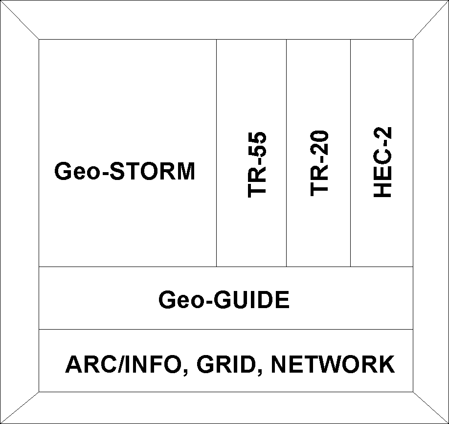
Geo-STORM encompasses the TR-55, TR-20, and HEC-2 models. These models are all contained within a graphic user interface environment within the ArcInfo GIS. The software is written in the ArcInfo fourth generation language, arc macro language (AML). There are external calls to the operating system only to execute the TR-20 and HEC-2 FORTRAN compiled models. The graphic user environment that is being used is a product developed by Innovative System Developers, Inc. called Geo-GUIDE. It is a graphic user interface to ArcInfo. A graphic showing the functional description of the applications is shown in figure 2.1.
Figure 2.1 Functional Description
The three models are integrated within the Geo-STORM software to provide a common interface and environment for the entire stormwater modeling procedure. The common interface provides easy interaction between the models as well as within each model. Switching between models is hardly noticeable, and outputs from one model are used as inputs to another model.
The TR-55 model application has been embedded within the TR-20 model application. The outputs from the TR-55 model become input values to the TR-20 input file. The TR-20 model application provides the discharge value as an input to the HEC-2 model, while the output from the HEC-2 model can be directly inserted into the TR-20 model as rating table information.
All the applications are accessible through a graphic user interface for ArcInfo. This provides ease of use to non-GIS professionals and allows the engineers to do their job. The models are embedded within the Geo-GUIDE graphic user interface which provides plotting, reporting, and querying capabilities for the stormwater modeling software suite.
There are many enhancements that are provided to the stormwater modeling solution through the use of GIS.
The ArcInfo GIS provides many powerful functions that aid in stormwater modeling. It is able to perform huge overlay processes, that take weeks to do by hand, in a matter of minutes. The tedious work of delineating subareas is a simple process for the GIS because it is able to read the surface and determine the highest points around an area. The process of determining the weighted curve number is completed by simply overlaying the landcover and soils data and creating polygons with the curve number values associated with them.
Another enhancement to the stormwater models is the ability to graphically depict output from the models. In TR-55 the subarea can be viewed on the screen with the time of concentration flow path with each flow type color coded. In TR-20 the hydrographs are plotted in a graph format to better describe the flow of water through the watershed. In HEC-2 the flood plain is created and can be overlaid with roads and buildings in order to really see what is being affected by the flow of water.
The link to the GIS database within the software supports easy change of variables within the model and quick re-execution. Having the database link also means that the data is always available for easy accessibility in the future when something changes in a watershed.
The GIS also provides many options for input data sets such as landcover, soils, and topography. If you don't have a dataset there are many ways to get it. There are many public data sources that have these data sets and usually for small fees. The stream network is not even required because functionality within the software can create a hydrologically correct stream centerline.
The many benefits of incorporating stormwater models into a GIS have significantly reduced the amount of time required to perform accurate stormwater analysis. The powerful functionality, great graphics, database link, and readily available data sets all enhance the stormwater modeling process.
The TR-20 software is organized into projects. This is a data storage scheme that holds all GIS coverages, grids and attribute tables in an ArcInfo workspace. Using the project to contain all the information allows the user to operate on many projects within a single TR-20 session. A project is created when a new TR-20 job is to be run.
When a project is opened, the database in the project is searched to see if any data has already been created. If there is any data, then it is opened and displayed on the screen. This makes it easy to continue working on an existing project.
There are a minimum of three data sets or themes that must be present to run the TR-20 software. They are: landcover, soils, and topography. A fourth data set, the stream network, is required, however, it can be produced from the topography set. These data sets are created by selecting the ArcInfo coverages that define them, and then mapping attribute values from those coverages to known software values.
Using ArcInfo coverages or grids as data sets allows for many different sources of data to be used in this model. The data sets can come from a local GIS database or any public data source such as the United States Geological Survey, and the United States Department of Agriculture Soil Conservation Service, etc. The variety of possible sources enables the user to acquire the data relatively inexpensively.
The first stage of running TR-20 is specifying the input data, this data is then used to create the input file. Using the GIS, this process is virtually automatic. Any data set in the GIS can be graphically displayed including: the stream network, topography, soils and landcover themes. Viewing these layers can help the user to decide where to place cross sections and the upstream and downstream ends of structures. The location of these positions can be specified by simply pointing and clicking with a mouse.
Once the positions have been determined, the rating tables for the cross sections can be entered or retrieved from the database. The program can retrieve the rating table from the GIS if it is stored as an attribute. Otherwise, the data can be entered through the graphical user interface. These values are put into an input file that is being created for the current TR-20 run.
After the cross section positions have been determined the software can immediately determine the curve number, drainage area, and time of concentration values for all the subareas, and creates output reports which can be viewed and printed. These values as well as the subarea boundaries are depicted in figure 3.1.
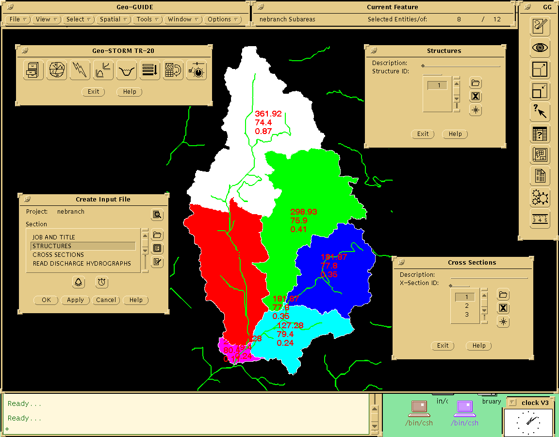
Figure 3.1 Subareas with CN, DA, and Tc
The TR-55 functionality is embedded in the TR-20 software. The weighted curve number (CN) and the drainage area (DA) are computed using the landcover, soils, and topographic database layers from a user specified design point. The design point can be anywhere along the stream network, and is selected by pointing and clicking with the mouse.
A coverage is produced showing the boundary of the subarea. This is graphically depicted in the GIS by a polygon coverage. The area of the polygon is already stored in the GIS as a default attribute and the CN is easily computed by spatial overlay functions. The GIS performs the overlay function and calculates a CN value, for the specified subarea, in a matter of minutes.
The time of concentration (Tc) for each subarea is computed using a GIS function that finds the shortest path between two points taking into consideration slope and landcover type. The Tc is computed from the three basic flow types: sheet, shallow concentrated, and channel. To determine the Tc, a point is graphically selected on the ridgeline using the mouse. Its path, from the point on the ridgeline to the design point, is automatically determined. A coverage is then created depicting the path that was determined. The land cover and elevation attributes are extracted from the GIS, and a report is created showing the distance and the Tc. This is easily recalculated by selecting a different point on the ridgeline. In the GIS the path is created as a line coverage and an attribute is assigned to the three different flow types. Using this attribute as a color symbol the flow path can be viewed showing each flow type in a different color.
The Geo-STORM software allows the user to perform what if operations where the user can change the land cover element of the database and recalculate the model values. Land cover areas can be selected using tools such as a box, polygon, or radius, or by overlaying another GIS database layer, such as property lines. The CN and Tc can then be determined based on the modified landcover type.
Default parameters can be set for use in calculating the CN and Tc. These values are stored in the GIS and can be updated at any time. The values that can be changed are the rainfall amount for each storm year, Manning's coefficient for each landcover type, and the CN value for each hydrologic soil group within each landcover type. Other values that can be set are the wetted perimeter and hydraulic radius of the stream.
In order to construct the standard control information for the TR-20 input file, the overall stream network must be analyzed with respect to the subareas within the watershed. The GIS provides tools that make this an easy process. Within the GIS the stream network is associated with the subarea data. This assigns the TR-55 values, CN, DA, and Tc, to the proper stream segments. Using the GIS datasets, the stream network is traversed from the top of the watershed to the last design point. The software is able to determine when a specific type of routing is needed, reservoir or reach, based on the GIS database information. The software is able to internally control the input and output hydrograph values and determine the order in which the subareas should appear in the standard control.
To run the model, the TR-20 input file must be created. This is a simple process of writing the database values to an ASCII text file. The database aspect of the GIS makes sure the data is in the correct position. The user does not have to worry that a value is out of the entry field or that a section is out of order in the input file. Each section is put into the input file in the correct position automatically.
After the input file has been created, the TR-20 model is executed using the specified input and output files. Once the model calculations are complete, the hydrograph elevation and discharge values, for all subareas, are extracted from the output and placed in the database.
Hydrographs are developed for runoff and local drainage along the channel, combined and routed as necessary to the outflow point. The software supports viewing of flood hydrographs for all subareas. This allows the user to compare the hydrographs of the subareas in the watershed. Figure 3.2 displays an example of output hydrograph data from a TR-20 run.
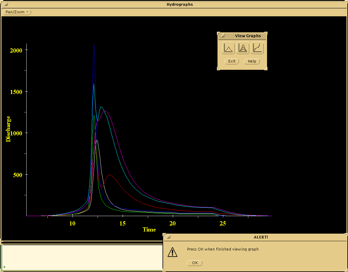
Figure 3.2 Output hydrograph from TR-20
The HEC-2 software is organized into projects. This is a data storage scheme that holds all GIS coverages, grids and attribute tables in an ArcInfo workspace. Using the project to contain all the information allows the user to operate on many projects within a single HEC-2 session. A project is created when a new HEC-2 job is to be run. The stream reaches that are to be included in the new HEC-2 job are selected from the screen and stored in the project.
When a project is opened, the database in the project is searched to see if any data has already been created. If there is any data, then it is opened and displayed on the screen. This makes it easy to continue working on an existing project.
In the HEC-2 software there are a variety of ways to create the input file. Every input record available in the HEC-2 software is accessible, so there is the possibility of manually entering all the data; however, the software provides many ways to interact with the GIS to create the input file.
Users are given the opportunity to enter as much or as little data as they want and the software will use the default value for any data that was not entered. If a cross section does not have a GR record then the elevation and station data will automatically be derived from the topography and a GR record will be created. If a reach length has not been determined the software will automatically determine it. If all the cross sections around a normal or special bridge have not been specified then the software will add the necessary cross sections. If a required record has not been entered a warning will be issued to the user telling which record is missing.
All job control records, cross section records, split flow records, bridge records, and change data records are accessed from within the software through an easy to understand graphic user interface. The records are presented using the card name and common terminology. This allows experienced as well as inexperienced users access to the HEC-2 model.
The HEC-2 software supports graphically positioning a cross section using the mouse. Just a point and click and the cross section has been specified. Other graphic functions include moving the cross section up or down the stream or deleting the cross section from the current project.
Once a cross section position has been specified many pieces of information can be retrieved from the GIS. The GR data records are automatically created when the user draws a line across the stream at the position of the cross section. The software reads the topographic data along this line and creates the GR data records.
Once the GR data records have been created a profile of the cross section can be viewed. The stations are graphically depicted so the left and right bank stations can be specified with the click of a mouse button. Once selected, the left and right bank stations are color coded, so that the user can easily identify them. The left and right bank station values are entered into the X1 record.
The left and right bank and channel reach lengths can be determined with the press of a button. The bank reach lengths are calculated from the bank stations of the current cross section to the previous cross section. The channel reach length is calculated by traversing the stream network. All these values are then entered into the X1 record.
Bridge and culvert data can be automatically determined from the GIS as well. Given just a few bridge attributes, the BT and GR records can be constructed for the bridge. All cross sections around the bridge are automatically positioned and all variables are entered. A special bridge or special culvert record can be added at the push of a button, and cross sections around the bridge or culvert are updated to reflect this change.
Another way to enter data into the GIS database is provided in the software by means of reading in an existing HEC-2 input file. The program reads and recognizes all the records and puts them into the database. Then all the user must do is graphically specify the position of all the HEC-2 cross sections, and the attribute data is attached to the graphic data.
Once the cross sections have been positioned, running the HEC-2 model is just a matter of pressing a button. The model is executed using the specified input and output files. After the model execution, the water surface elevation data is extracted from the output file and put into the database. The output file that is created can be viewed on the screen or printed.
The water surface elevation data that is extracted from the output file is associated with each graphic cross section position. The elevation data is used in association with the topography to produce a graphic depiction of the flood plain. The flood plain is interpolated between cross section positions in order to depict the flood plain throughout the entire HEC-2 run. A graphic of a flood plain created from a HEC-2 run is shown in figure 3.3.
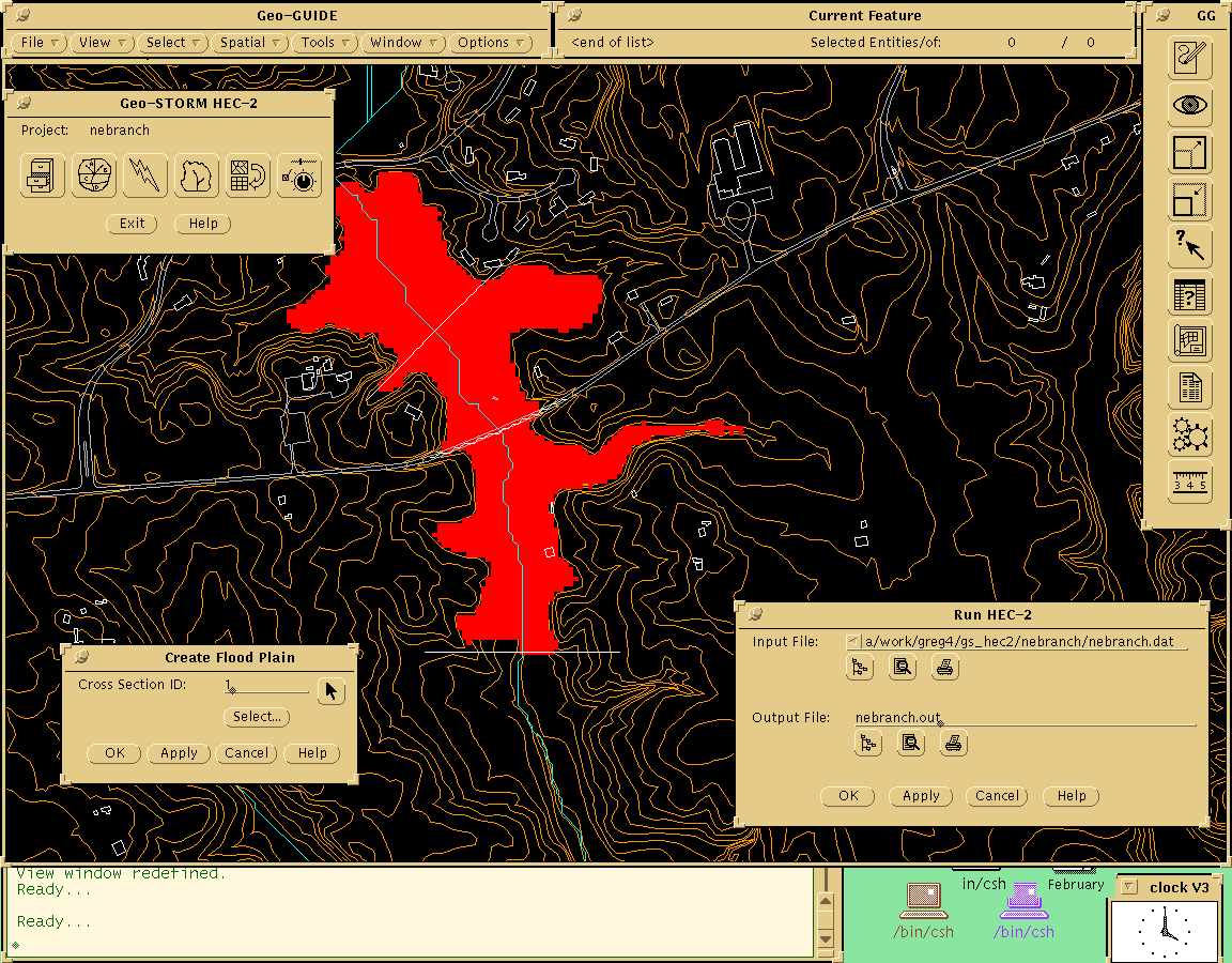
Figure 3.3 Flood plain created from HEC-2 output data.
There are many advantages to having the stormwater models executing within a GIS environment. The direct link to the GIS database, many options for using data, great visual interaction, and the powerful functionality contained within the ArcInfo GIS that makes the mundane processes of stormwater modeling much simpler and quicker.
The Geo-STORM software was created with an easy to understand graphic user interface. This was provided to help users interact with the software and perform modeling quickly. The software was also written within a graphic user interface to ArcInfo, Geo-GUIDE, which provides many further functions that allow users to interact with ArcInfo to produce plots and reports, and do spatial analysis.
Many aspects of the software are easily changeable. The characteristics of a subarea, such as the landcover type, can be changed very easily to model future conditions. Properties for all the models are defined and easy to change through the interface. Using the database element of ArcInfo all the data records can easily be changed. The database element also insures that the data is always in the proper format for the input file.
Using the GIS, graphic capabilities are greatly enhanced. The software provides the ability for users to view a 3-D perspective of a subarea. Hydrographs created in the TR-20 model can be displayed in graph form to compare upstream and downstream values. Using the elevation data and the topographic surface the flood plain can be created and viewed. Other layers, such as roads and buildings, can be overlaid on the flood plain to see what the effect of the water is on the real world. The cross section profiles can be drawn on the screen so the user can pick the right and left bank stations as well as create output plots.
The network feature of the GIS is used to automatically traverse the stream network to build the standard control in the TR-20 model. The network feature is also used to compute channel reach lengths in the HEC-2 model.
Geo-STORM is a complete GIS-based stormwater modeling solution. The solution contains the TR-55, TR-20, and the HEC-2 models. It is a complete solution because it allows hydrological engineers and hydraulics engineers to model stormwater from ridgeline to outfall in an accurate, efficient manner.
The functional analysis section of this paper demonstrated how the application of GIS-based stormwater modeling tools can help engineers conduct analysis in a fraction of the time required with conventional methods. Using a GIS system, especially one like ArcInfo, to help in stormwater modeling brings about many benefits. They include graphic output capabilities, easier what if analysis, and an easy to understand graphic user interface. This allows the engineers to work through many more scenarios to make better informed stormwater decisions.
1. United States Department of Agriculture Soil Conservation Service Engineering Division. Second Edition June 1986. Urban Hydrology for Small Watersheds Technical Release 55.
2. United States Department of Agriculture Soil Conservation Service. Draft of Second Edition. May 1983. TR-20 Computer Program For Project Formulation - Hydrology.
3. United States Department of Agriculture Soil Conservation Service. Amendment 6 March 1985. National Engineering Handbook; Section 4 (NEH-4) - Hydrology.
4. United States Army Corps of Engineers. September, 1990. HEC-2 Water Surface Profiles User's Manual. Hydrologic Engineering Center.
5. Environmental System Research Institute, Inc. 1992. Understanding GIS - The ArcInfo Method.
coverage a digital version of a map forming the basic unit of vector data storage in ArcInfo
cross-section boundary geometry of the stream; ground surface profile. Required at representative locations, such as where changes occur in discharge, slope, shape, or roughness; where levees begin or end; and where bridges, culverts or control structures such as weirs appear along the stream.
data point location along the ground surface profile of the cross-section, identified by its horizontal distance from the zero point on the left side of the stream, looking downstream. Synonymous with station point.
GIS a computer system capable of holding and using data describing places on the earth's surface.
grid a raster data set used with ArcInfo's GRID module where data is stored in row and column format.
layer a data set composed of one theme such as soils or landcover.
point of interest location on a stream channel that represents a cross section position.
station point synonymous with data point.
reach length the measured distance between cross-sections.
subarea one or more portions of the watershed under study that is/are hydrologically homogenous in size, landuse, and rainfall distribution representative of the watershed.
subwatershed synonymous with subarea.
workspace a directory where coverages and grids are stored and contains an info directory storing database tables.
Greg Thomas
Project Manager
Innovative System Developers, Inc.
5950 Symphony Woods Rd. Ste. 311
Columbia, MD 21044
Telephone: (410) 997-3358
Fax: (410) 997-3560