 USING ArcInfo TO COMPLY WITH NATIONAL POLLUTANT
DISCHARGE ELIMINATION SYSTEM (NPDES) REGULATIONS
William Kaftan
USING ArcInfo TO COMPLY WITH NATIONAL POLLUTANT
DISCHARGE ELIMINATION SYSTEM (NPDES) REGULATIONS
William Kaftan
USING ArcInfo TO COMPLY WITH NATIONAL POLLUTANT DISCHARGE
ELIMINATION SYSTEM (NPDES) REGULATIONS
NPDES regulations are a result of the re-authorization of
The Clean Water Act of 1987. They require permit applications
and compliance for municipal storm-drain systems for
municipalities having populations of 100,000 or more. Programs
involve a storm-drain utilities inventory system,
water-quality sampling, and long range storm-water-quality
management. This paper presents Riverside County,
California's, application of ArcInfo to comply with these
requirements. It also presents the County's use of ArcInfo
to manage and make equitable the Clean-water/Storm-water
property tax assessment which is used to fund the NPDES
program.
THE STORM-WATER/CLEAN-WATER PROTECTION PROGRAM
History
The Riverside County Storm-water/Clean-water Protection
Program was developed in response to the federal regulations
authorized in the Clean Water Act. These National Pollutant
Discharge Elimination System (NPDES) regulations require local
authorities to control non-point source pollutants from
entering the Nations Waterways.
When Congress adopted
the Federal Clean Water Act of 1972 it required that a permit
be obtained to discharge pollutants into the waters of the
United States. In 1983 the EPA conducted a study which
concluded that storm-water run-off from urban and industrial
areas contained the same types of pollutants as point-source
or industrial discharges. Therefore storm-water run-off was
considered just as much of a threat as industrial
discharges.
In 1987 the Clean Water Act was amended to include this
non-point source storm-water run-off. In November of 1990 the
EPA published final regulations and the County's Storm-
water/Clean-water program was formed following these
regulations.
Regulatory Structure
The authority to implement and enforce this program lies
with the California State Water Resources Control Board
(SWRCB). Subsequently there are nine Regional Water Control
Boards (RWQCB), three fall within Riverside County.
THE FUNDING SOURCE
History
Although the Federal Government mandates this program it
does not fund it. To fund this program the County of Riverside
formed County Service Area 152, (CSA 152) which appears on the
County Property Tax Bills. In the first year of the existence
of CSA 152 it was determined that no parcel should be charged
more than $10 for it's contribution to the CSA. At this time
there was; however, no exemption criteria so every tax
assessment was set at $10.
As time went on it was determined that it was unreasonable
to levy an "equalized" parcel charge against all parcels in
the County. It had been previously established through
litigation that "a special assessment is a charge levied
against real property particularly and directly benefited by
a local improvement, in order to pay the cost of that
improvement." It was then decided that the area and the land
use of the parcel should be factored into a formula to
determine how much a parcel's assessment should be.
So a study of each land use and it's relationship to the
amount of storm-water run-off pollution was made and a factor
for each land use was determined for an assessment formula.
For example, commercial or industrial land uses received a
much higher land use factor than golf courses or residential
areas. Some land uses, for example vacant, would not be
charged.
ASSESSMENT CALCULATIONS
Creating Rate Areas
The Assessment Formula needed one more factor to be
complete, a RATE. For example, the formula was to look like
this:
AREA * LAND-USE-FACTOR * RATE = ASSESSMENT
If you know the total area for each assessable land use
designation, then applying the land use factor to each of
these totals will give you the total Benefit Assessment Units
(BAUS). For example:
AREA * LAND-USE-FACTOR = BAUS.
Knowing the total BAUS of an area, and how much revenue
will be needed to administer the program to the area (the
COST), one can determine the RATE for an area. For
example:
RATE = COST / TOTAL-BAUS
Since much of Riverside County is un-urbanized and
virtually uninhabitable, it was determined that two areas (
ZONE-A "more urbanized" and ZONE-B "less urbanized" ) should
be created and the "RATE" for ZONE-A should be substantially
higher than the "RATE" of ZONE-B. The more "urbanized zone"
would receive a higher level of service, including street
sweeping and catch basin cleaning, which causes the "COST" to
administer the program to be driven up. In both "urbanized"
and "less urbanized" zones , the "RATE" would be a direct
calculation based on the level of service.
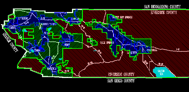
The County's GIS was used to form ZONE-A and ZONE-B. It was
decided that three criteria would be used to determine where
the "more-urbanized" and "less-urbanized" zones would be
established.
A. Population per square mile.
B. Parcels per square mile.
C. Parcels with structures per square mile.
The first step in determining the zones was to establish
a study areas. Study areas are polygons having common
attributes which comprise the entire County and divide it into
many parts. Each of these study areas are analyzed and rated
for the three criteria (common attributes).
One could have formed study areas using townships or
sections, however; parcels would be severed by the study area
boundaries causing confusion in the final analyses when
ascertaining which parcels belong to which zone. It was
decided, therefore, that the study area boundaries should be
derived from parcel lines.
In Riverside County, historically, the entire parcel layer
was mapped by the Assessor's Office and placed in Assessor's
Books. These Assessor's Books are stored in the Assessor's
office for public record. The books consist of 11 by 17 inch
pages and are about 3 inches thick on average. The area
covered by an Assessor Book is contiguous.
The first three digits of the nine digit Assessor's Parcels
Number (APN) indicates in which Assessor's Book the parcel can
be found in. The nearly 7300 square miles in Riverside County
are divided into 534 Assessor's Books. The books having more
dense development cover a smaller area so the distinction of
Assessors Book Boundaries is finer in the more urbanized
areas. In the final analysis, it would take a table of only
534 records to determine which zone any parcel belongs to
using the first three digits of the Assessor's Parcel Number.
For these reasons the Assessor's Books were used as study
areas.
The next step was to assign attributes in the Assessor's
Book Coverage's PAT to store the values for population,
parcels, and parcels with structures. The number of parcels
and parcels with structures could be easily summed up with
links to the assessor's database. Population values were a
little harder to calculate. This method involved a polygon
overlay with census block coverages. If a census block fell
totally within an assessor's book polygon then the total
population attributed to that block would be added to the
population value of the Assessor's Book polygon. If a census
block fell partially within an assessor's book polygon, then
the ratio of that area, that fell within, over the total area
of the census block would be multiplied times the population
attributed to the census block and added to the population of
the Assessor's Book. Once the totals for population, parcels,
and parcels with structures were calculated in the Assessor's
Book PAT, the Assessor's Book polygon area attribute was used
to determine per-square mile statistics for the criteria.
Statistics were run on population per square mile, parcels per
square mile, and parcels with structures per square mile to
determine minimums, maximums, means, averages, and totals.
Using these statistics, cut-off values were established as
such.
A. Population per square mile...........200 people.
B. Parcels per square mile................100 parcels.
C. Parcels w/structures per square mile....50 parcels.
Any assessor's book which exceeded at least two of these
categories would be considered a "more-urbanized" assessor's
book and added to ZONE-A.
Next a study of the COST to service ZONE-A and ZONE-B was
conducted. It was then necessary to summarize the total BAUS
for each zone. (see formula for calculating BAUS mentioned
previously.) Having the Total BAUS for each zone and knowing
the COST to implement the program, the RATE was calculated
with the previously mentioned formula.
Investigating Land Use Discrepancies
Although the Assessor assigns a land use designation to
each new parcel created, in many cases, these values may have
to be altered. For example, a parcel may be assigned an
agriculture land use but since the owner has put up a fruit
stand, the actual land use is commercial with regards to our
assessment program.
Since we have a land use layer in one of our GIS libraries
that concerns itself with "actual land use", as it was derived
from areal photographs, we can draw this layer on the screen
to help determine "actual land use" for the assessment, or we
can perform polygon overlays, with background processes, to
check new assessments for discrepancies between the "actual
land use" and the land use assigned by the Assessor as part
of an update to the Assessment Database.
Resolving Acreage Discrepancies
When a new Assessor's Parcel is created it's acreage, if
available, is entered into the Assessor's database, which is
linked to the GIS Parcel layer PAT by the Assessor's Parcel
Number. (APN) Many times when Assessor's personnel enter the
APN into the Assessor's Database, they do not have acreage
information. Without a parcel's acreage it is impossible to
determine the parcel's assessment. Since the parcel probably
has been digitized into the GIS Parcel layer, the acreage
information may be extracted from GIS, as part of the
assessment database update process, while producing a
report.
In many cases some of the area of a parcel may be actually
undeveloped land, although the entire area of the parcel is
classified by a land use code which generates BAUS. For some
of the higher rated land use codes ( for example commercial
codes ) undeveloped land may create a large unfair assessment.
The Landuse Layer may give a good idea of how much a parcel's
acreage is actually developed when intersected with the Parcel
Layer.
Screening Unusually High Assessments
When calculating NPDES assessments an exception report is
printed out for any assessment over 100 BAUS ( 100 times the
RATE ). These exceptions are investigated. In many cases, new
assessments may have to be equalized or given an alternative
acreage or land use designation in the NPDES Assessment
Database.
The Override NPDES Database
When assessments are unfair using assessor's land use or
acreage data, override data elements are created in the
exception data fields. Of course the actual Assessor's data
is never altered. Therefore the Override Database continues
to grow as parcels are reviewed because of exception reports,
or inquires from the public. In all cases, if override data
exists, it is used in the assessment calculation.
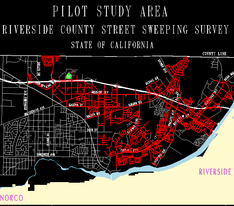
DETERMINING STREET SWEEPING ROUTES
Street sweeping is considered a Best Management Practice
(BMP) towards compliance with the NPDES regulations. Many
pollutants that wind up in our storm-drains can be found on
the street, deposited by automobiles or dumped by residents
of the neighborhood.
Considering limited fiscal resources, the task of
determining which, of the thousands of streets, will be swept,
is made possible by our Street Sweeping GIS application.
Structuring the Database
The following three factors were determined to be relevant
in selecting prime street sweep candidates:
1. Land use
2. Surface type
3. The existence curb and gutter
Certain land use codes, for example High Density Single
Family Residential or Commercial Strip Development, are
considered high priority land use's when selecting candidates
for street sweeping.
The Riverside County GIS Land Use Layer has 129 unique land
use classifications connected to the Landuse PAT related by
a landuse code. Of these 129, we determined 58 to be the
landuse types through which street primary sweeping candidates
pass. An info key-file was created for selecting these land
use codes by copying the Landuse Look-up Table and purging the
unwanted records.
The road Centerline Layer in our GIS classifies our roads
in terms of surface type, whether the road is owned by or
maintained by the County, and the General Plan type. Selection
key-files were created in the same way, as mentioned
previously, with landuse designations. County maintained paved
roads were (for example) the primary target for street
sweeping in this regard. Of the 30 centerline classifications
we have, 9 of them were used in our selection key-file.
The County maintains a separate database as part of the
Pavement Management System, that may be linked to the GIS
Centerline Layer AAT by a road number. The road number
historically was created for record keeping including
maintenance and cost accounting. This database allows us to
determine whether a road has curb and gutter on one or both
sides.
Next an identity is performed on the Centerline layer using
the Land Use Layer as the identity coverage thereby adding
land use attributes to the arc attributes of a county wide
street sweeping coverage.
Establishing Selection Criteria
Now, having a county wide line coverage with attributes for
the three criteria previously mentioned, and having created
the info selection files identifying the attributes of the
prime candidates, we are able to select arcs for street
sweeping in Arcplot using the Reselect command with the Key-
file option.
Creating Street Sweeping Zones
Obviously when selecting Road Candidates for street
sweeping on a county wide basis (Riverside County is about
7300 square miles) you are attempting to create several
different street sweeping routes, rather than one route.
When you select streets based on the previously mentioned
criteria, you will have many different fragments of streets
somewhat connected but more so connected in areas of dense
development.
We will now want to form street sweeping zones which
determine where a route will be created. When we created our
street sweeping route study areas, we decided that if a street
sweep candidate (SSP) fell within 1/2 mile of another SSP, the
two candidates should be considered part of the same route.
In other words, we are not willing to drive more than 1/2
miles over streets we do not target for sweeping to get to a
street we target. In resolution, we buffered 1/4 mile (1320
feet) around our "prime targets" as the first step in creating
our street sweep zones within which we created our routes.
This created a number of polygons greatly varying in area.
The smaller polygons were zones where few "candidates" were
in proximity to each other and the larger polygons indicated
areas where many candidates were in proximity to each other.
Using summary statistics, knowing the per-mile cost of street
sweeping, we were able to estimate how much it would cost to
implement street sweeping in each zone. Our intent is to
implement street sweeping in as many of the largest zones as
possible within budget limitations.
Adding Links
After selecting a zone, for implementation of the Street
Sweeping Program, a refined study was made using GIS. A menu
driven application was developed that enabled the analyst to
add to or remove streets as candidates, interactively, for any
zone, in an effort to create logical connected routes. The
user is able to query all the attributes of any arc, or set
of arcs, and generate statistics about landuse, surface type,
mileage, and costs, while viewing the arcs graphically with
various geographic features in the background. Finally, one
may generate a statistical report accompanied with maps of
each of many alternative routes. Finally, upon selecting an
alternative, the maps and reports are used in the bidding
process by various street sweeping services companies.
Funding
A GIS application is now being developed, for the County
of Riverside, to determine those parcels which are benefited
directly by street sweeping. The application will not only
determine which parcels lie adjacent to a route, but also will
calculate an assessment based on cost per-mile to sweep and
the amount of frontage attributed to the parcel.
With the Parcel layer linked to the Assessor's database,
tax assessments will be automatically generated and forwarded
to the Auditor/Controller's Office to be added to the property
tax bill.
THE STORM-DRAIN INVENTORY
NPDES regulations state specifically that an inventory of
the Storm Drain System be created and maintained. We have
chosen to create this inventory as a layer in our GIS
library.
We also will produce the Storm Drain Facilities and
Drainage Easement Map Book, as part of our compliance to these
regulations. The Stormdrain layer is a line coverage with line
and node attributes and the Drainage Easement layer is a
polygon coverage with polygon attributes.
Stormdrain Line Attributes
SD-NUMBER is used by the County for accounting and
maintenance history tracking purposes by the field crews. If
there is a maintained road associated with the stormdrain
line, then this field will be the same as the maintained road
number.
WIDTH is width of the facility in inches. If the facility
is a pipe (round) the width will be the diameter. If the width
of the facility varies, then the average width will be the
WIDTH.
DEPTH is the depth of the facility in inches, from the top,
to the bottom. The depth is not measured from the surface of
the ground to the top or bottom of the facility. If the
facility is a pipe (round) the DEPTH will be the diameter. If
the depth of the facility varies, then the average depth will
be the DEPTH.
TYPE is the major classification of the facility
distinguished by a code that relates to an info file that
provides a symbol and a description in cross reference. This
field is redefined into two categories, P-TYPE and R-TYPE.
CONTACT This field holds an associated record number to a
related CONTACTS file. The CONTACTS file contains information
concerning 'who to contact' for maintenance, access
permission, reporting of emergencies, pre-excavation
information (etc).
PLAN-NUMBER The improvement plan (design) file number as
provided by the Survey Department.
P-TYPE The physical classification of the utility, or what
type of construction it is. This code references a description
in a related file having the following classifications:
OPEN DIRT DITCH
OPEN ROCK LINED DITCH
OPEN CONCRETE CHANNEL
UNDERGROUND AQUEDUCT
REINFORCED CONCRETE PIPE
CORRUGATED METAL PIPE
PLASTIC VINYL PIPE (P.V.C.)
R-TYPE The legal implications of responsibility and use.
This code references a description in the related file having
the following classifications:
COUNTY MAINTAINED
FLOOD CONTROL MAINTAINED
C.S.A. MAINTAINED
NON-MAINTAINED PUBLIC USE
NON-MAINTAINED PRIVATE
CITY MAINTAINED
MAINTAINED BY OTHER ENTITY
Stormdrain Node Attributes
TYPE The type of in-line structure for the stormdrain
layer. Each code is linked to a description and symbol in a
related file. The descriptions are as follows:
CONNECTION TO OTHER SYSTEM
CURB CATCH BASIN
DRAINAGE INLET
DRAINAGE OUTLET
GRATED CATCH BASIN
MANHOLE
CONTACT This field holds an associated record number to a
related CONTACTS file.
FL-ELEVATION The elevation at the position of the node on
the flow line of the storm drain utility.
GR-ELEVATION The elevation at ground level above the
position of the node.
Drainage Easements Polygon Attributes
DATE-RECORDED The recordation date of the instrument or map
that created the easement.
REFERENCE A reference to the document that created the
easement.
Illicit Discharges
NPDES regulations state that illicit discharges should be
tracked and action should be taken to legalize them. Our NPDES
Stormdrain layer will allow us to locate and track proceedings
against illicit discharges through our stormdrain maintenance
record tracking system.
Pollutant tracing
Each stormdrain line is created or edited to have a
direction of flow. (The to node is always downstream). In the
future we will test water quality at sampling stations along
the stormdrain. A sampling station test result file will be
linked to the stormdrain node attribute table.
Our Parcel Layer Polygon Attribute Table will be linked to
a Standard Industrial Code (SIC) Table by Assessor's Parcel
Number. This table will indicate what types of industrial
activities, take place on the parcel. Another table which
associates pollutants with the (SIC) code will be created and
linked to the SIC Table by SIC-CODE.
The Stormdrain nodes will be linked to the Parcel Layer
Polygon Attribute Table by performing an identity process.
Stormdrain nodes will also be related by Assessor's Parcel
Number.
When a contamination is identified at any of the sampling
stations, a tracing program will be executed which searches
upstream, following a pattern of from-nodes and to-nodes,
identifying all parcels of land which exist upstream from the
sampling station that detected the pollutant. The parcels with
SIC codes that are linked to the pollutant will be highlighted
and listed in an exception report.
Contact Agencies
It has been determined that in the event of an emergency,
for example, a broken or clogged storm drain line, when the
County is reached one may locate a storm drain facility by an
address, or by a parcel owner's name, or any other feature(s)
in the GIS. The user may then point to the stormdrain and
obtain the organization, phone number, and person responsible
for the maintenance of the facility.
CONCLUSION
After the EPA had determined that non-point (from urban
storm water run-off) pollution contributes as much pollutants
as point source (industrial discharges), to our nations
waterways, the Clean Water Act was amended to include
non-point source pollutant controls. This amendment has been
reviewed and interpreted by the EPA, who has published the
NPDES regulations.
In following these regulations, Riverside County has made
use of its GIS in several different aspects. Riverside County
has piloted a GIS storm drain inventory and drainage easement
layer. We believe these layers will prove to be much more
effective than conventional tabular inventory systems as they
will be used to create the Storm Drain and Drainage Easement
Map Book. Furthermore, upstream contaminant tracing and
hydrological flow modeling will be possible using these
layers.
We have also been generating NPDES tax assessments to fund
our program with our GIS. We have created and maintained
assessment rate areas based on geographic "urbanization"
criteria to more closely relate those assessed to those
benefited. We have used our GIS to research and uncover
assessments that need to be more closely examined and
equalized.
Realizing that street sweeping is an important BMP to
implement, we have, using our GIS, determined street sweeping
routes while targeting county maintained roads having certain
landuse, pavement type, and design characteristics to make the
best use of the limited money available for street
sweeping.
William Kaftan,Engineering Systems Programmer Analyst
Riverside County Geographic Information System
4080 Lemon Street, mail stop 1260
Riverside, CA 92501
Telephone (909) 275-2086
Fax: (909) 275-6814