In 1994, the Louisville/Jefferson County Information Consortium (LOJIC) completed the first update of its ArcInfo planimetric and topographic base map of Jefferson County, Kentucky. The base map update began with a detailed change detection effort performed by LOJIC staff utilizing satellite imagery and aerial photography to determine those areas of the county that most required updating. Update areas were quantified and prioritized based on the magnitude of change, user requirements and budgetary limitations. The resultant project, completed by Analytical Surveys, Inc. (ASI) through the use of photogrammetric superimposition techniques, involved the update of nearly one half of the 390 square miles of LOJIC base mapping. This paper describes the change detection process, project specifications, general compilation techniques and quality control procedures used for the base map update, as well as subsequent modifications and retiling of the base map to enhance the functionality of the overall photogrammetric database.
INTRODUCTION


The original LOJIC base map, photogrammetrically compiled to National
Map Accuracy Standards at a scale of 1((=100( from 1986 and 1989 aerial
photography, contained 25 layers of planimetric and topographic data
controlled to the Kentucky Coordinate System, NAD83 and the NGVD29. The
approximately 390 square miles of  LOJIC Plan/Topo Data (PTD) was
organized into a standard ArcInfo librarian database consisting of
1,030 contiguous tiles of digital map data. The PTD served as the
foundation database for the multi-agency LOJIC GIS in providing primary
geographic reference for the subsequent creation of additional layers
such as land parcels, street centerlines/address ranges, flood limits,
watersheds, soils, political/administrative districts and sewer
infrastructure. The PTD rapidly became the authoritative base map of
Jefferson County, Kentucky and was used to support myriad public and
private development projects as well as a primary source of revenue in
the sale of LOJIC GIS products and services.


The importance of the PTD to LOJIC users coupled with the fact that
nearly all other layers in the LOJIC GIS are either tied to or derived
from a subset of the PTD, resulted in the demand for an updated base
map even before the completion of the original conversion.
Photogrammetric recompilation of at least some portion of the PTD, with
adherence to the original compilation/database specifications, was
determined to be the only viable approach to maintaining the detail and
accuracy standards of the original data (see Appendix 1). Since
budgetary limitations dictated that recompilation of the entire county
was not feasible (original conversion costs were $3.1 million) an
internal study was initiated to determine which areas of the county had
undergone significant change. The study served to define the relative
magnitude of the change; cooperatively determine the priority of each
change area; and obtain the maximum photogrammetric update within
existing budgetary limitations.
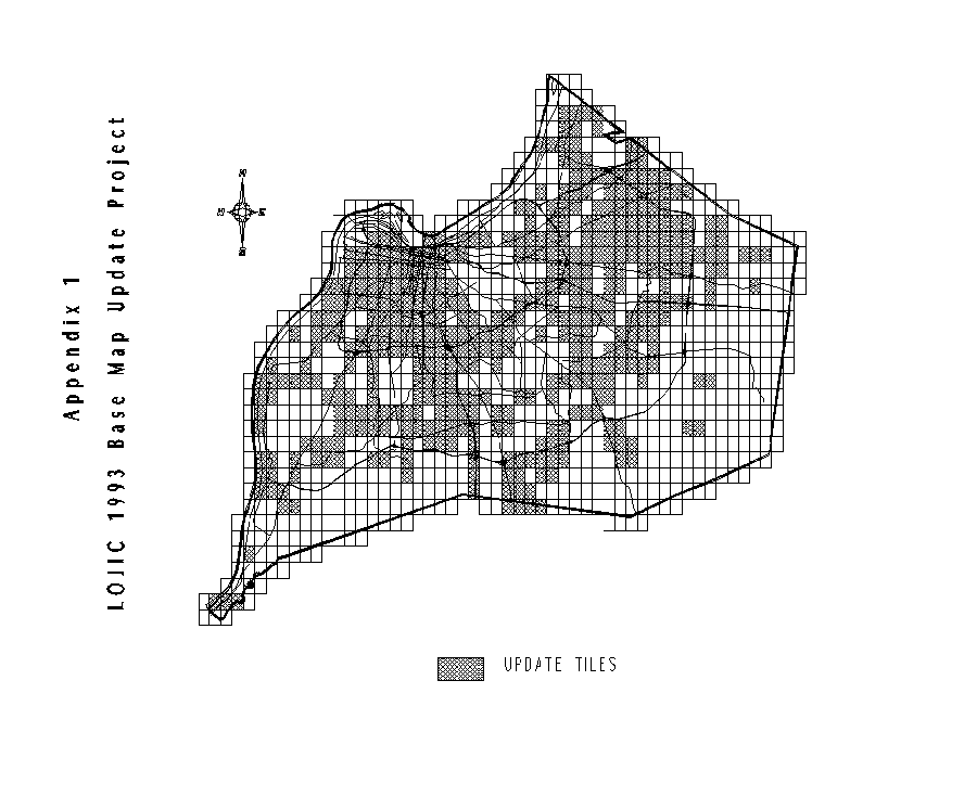
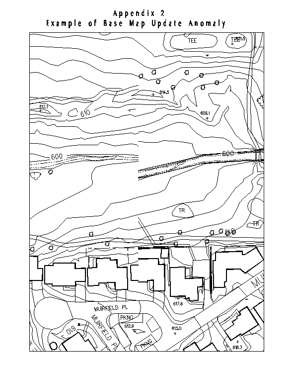
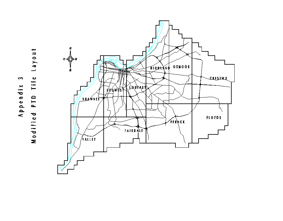
CHANGE DETECTION In the original LOJIC base map, the western 60% of Jefferson County was compiled from 1986 aerial photography and the eastern 40% from 1989 photography. Well before the completion of the base mapping project in August of 1990, it became apparent that some level of updating was needed as soon as possible. Residential and commercial land development activities remained fairly active throughout the duration of the base mapping project. According to Louisville and Jefferson County Planning Commission records, approximately 8,000 new subdivision lots were created from 1988 through the first quarter of 1992. Approximately 6,000 permits were issued for single-family residential units during the same period of time. Midway through the base mapping project, LOJIC staff and Plangraphics, Inc. attempted to formulate a change detection plan based on the use of existing permit data and other hardcopy records from the Planning Commission, City Inspections/Permits/Licenses, County Code Enforcement and the Property Valuation Administrator. Existing records from these agencies were gathered for specific areas of the county to evaluate their usefulness in determining the location and magnitude of development and construction activities. This exercise revealed that existing agency records lacked the spatial and descriptive information necessary to serve as a reliable source for monitoring changes in the developed landscape. The reliability of using permit records as change indicators will improve over time as more development review agencies utilize LOJIC to track specific development and construction activities. As a short term solution, LOJIC staff implemented a change detection study based on detailed visual analysis of satellite imagery and aerial photography as a means of identifying and categorizing areas of the county which were most deserving of planimetric/topographic map updates.Change detection source materials The primary photographic source materials used by LOJIC staff in defining/categorizing change areas throughout the county included 1(=660( aerial photography (from 1986, 1989 and 1991) and 1"=2,000' satellite change analysis imagery prepared by SPOT Image Corporation and Earth Satellite Corporation (EarthSat). Aerial photography meeting specifications and flight line layout identical to that of the 1986 and 1989 flying was obtained in the Spring of 1991 for purposes of change detection and possible use in the actual map update process. LOJIC also obtained SPOT satellite imagery from Spring 1988 (the earliest imagery of Jefferson County on file) and new imagery from Spring 1991 to coincide with the latest air photo acquisition. Both images consisted of digital raster files captured at ten-meter pixel resolution. The 1988 image was geo-referenced to Kentucky State Plane, North Zone (NAD 83) with the 1991 image rectified to the 1988 scene. Once the two image files were geometrically registered to the same base, they were displayed together as a composite photograph. By assigning the blue/green image bands to the 1988 scene and the red band to the 1991 scene, it was possible to display areas of change as the result of pixel by pixel analysis of differences in image signature caused by variations in object reflectance. Areas which had not changed appeared on the composite in shades of gray, while areas that had changed appeared as red/blue features. Most urban change such as new buildings, roadways, parking lots and major excavation represented a change in reflectance from dark to light and appeared as shades of red on the composite image. Changes related to finish grading, increased vegetative cover and standing water represented a change in reflectance from light to dark and appeared on the composite as shades of blue. EarthSat also included LOJIC tile and municipal boundaries on the final 1:24,000 composite change detection imagery to provide a consistent visual reference to the LOJIC map data. EarthSat created an ArcInfo polygon layer of change areas from imagery pixels having a "red" signature value threshold which represented the reflectance variance from dark to light. LOJIC staff had hoped to use this data to forego the task of digitizing specific change area boundaries for purposes of defining and categorizing change per tile. The relatively narrow comparison threshold used in aggregating red/blue pixels coupled with the spatial filter used to mask out change features smaller than approximately two acres, resulted in image-based change polygons that lacked the level of detail and comprehensiveness required to justify the use of this data as the only source for locating areas of change. In light of this, LOJIC staff proceeded with a complete frame by frame comparison of existing aerial photography, using the composite satellite imagery as a visual reference, as the means to more specifically define and classify change areas throughout the county. Aerial photo analysis Since the flight lines for the three years of aerial photography were nearly identical, contact prints from the different photo dates proved to be comparable in coverage area. LOJIC staff identified specific frames from the 1986 and 1989 photography used in the original base map compilation and compared them to the 1991 photography. Variations in features between the different years of photography were delineated on county quadrant maps produced for this purpose from the LOJIC GIS. LOJIC staff further updated the results of the change detection analysis using Spring 1992 photography, as well as Spring 1993 photography which was used for the actual photogrammetric updates. Change classifications. Each change area polygon identified from the aerial photography and delineated on the quadrant maps was assigned a classification code according to the following types of change as interpreted from the satellite imagery and the aerial photography. Code Description 1 Major buildings - Addition/demolition of large structures such as factories, office parks, warehouses, etc. 2 Minor buildings - Addition/demolition of smaller structures such as single houses, storage buildings, single-use commercial buildings, etc. 3 Major roads - Addition/demolition of major thoroughfares such as interstates, ramps primary roads, connectors, etc. 4 Minor roads - Addition/demolition of secondary/local streets including small subdivisions, etc. 5 Major miscellaneous - Addition/demolition involving large paved areas and major construction sites. This classification is a primary indicator for new developments involving combinations of features (i.e. structures, roads, parking lots, grading) in previously undeveloped land. 6 Minor miscellaneous - Addition/demolition of smaller paved areas, grading and other minor construction. This classification is a primary indicator of small additions to existing subdivisions. Only areal features identified from either individual or stereoscopic photo images were considered, captured and coded as valid changes. Changes in point features (i.e. poles, manholes, etc.) were not evaluated. Areal features considered as changes for purposes of this analysis included buildings comparable to single residential structures or larger; roadways longer than twenty feet; and other change areas (i.e. grading, paving, etc.) greater than or equal to 5,000 square feet. Change areas were digitized into LOJIC as a single ArcInfo polygon layer. Each polygon was assigned the appropriate classification code and the entire layer was intersected with the PTD tile index layer to identify specific tiles that contained various combinations of change classifications. Plots of the county quadrants were produced to illustrate the spatial distribution of the change areas, as well as those tiles which contained no apparent change. Of the total 1,030 tiles of base map data, 469 (46%) were found to contain some type of change area. Of these, 342 tiles were found to contain major change classifications. The decision was made to proceed with the update of the tiles which contained major changes and the update of additional tiles should the project budget allow. The scope of work eventually negotiated with Analytical Surveys, Inc. (ASI) involved the photogrammetric update of 425 tiles of base map data. The overall scope of work for the base map update project was driven by the following assumptions: 1. All layers of the selected tiles would be photogrammetrically updated, regardless of the photo models involved. 2. Photogrammetric compilation using Spring 1993 photography and stereo superimposition would provide the most appropriate detail and accuracy. 3. All horizontal/vertical control from the original base mapping would be transferred to the 1993 photography for use in developing another full-county control solution. This was especially practical given the distribution of change areas and the marginal cost savings of partial control solutions. 4. Flight lines for new photography would be controlled along tile centers to minimize the number of photogrammetric model sets. OVERVIEW OF PHOTOGRAMMETRIC UPDATE PROJECT The photogrammetric update to the LOJIC base map was achieved through the successful completion of the following project phases within a one year project duration. Each project phase was undertaken following written notification to proceed and acceptance of all work and deliverable materials associated with each preceding phase of the project. Initiation Phase . Preparation of aerial photography flight plan . Acquisition of Spring 1993 aerial photography and related products . Transmittal of all control photos, film diapositives, analytical triangulation solutions, and ArcInfo digital map library databases from the original LOJIC PTD to ASI . Preparation and review of draft Procedures Manual for the update project . Transfer of photo control from the 1986 photography to 1993 photography and completion of new analytical triangulation solution Prototype Phase . Photogrammetric update of ten contiguous tiles of PTD selected as an initial test of production procedures and project specifications . Delivery and joint review of check plots, digital map tiles and aerial photo enlargements for the prototype area . Preparation of final Procedures Manual revised to reflect modifications in production and technical specifications resulting from the experience with the prototype Production Phase . Produce photogrammetric updates of 415 tiles of LOJIC PTD by priority production areas defined by LOJIC . Delivery of check plots, digital map tiles and aerial photo enlargements for each priority production area . Detailed check of all production area materials by LOJIC with resultant edits and corrections reflected on final mylar plots and ArcInfo files of each PTD tile Aerial Photography and Control The Spring 1993 aerial photography used for the update project was acquired for the entire area of Jefferson County along east-west flight lines centered on existing PTD tiles. This allowed for maximum model coverage for each tile and minimized the number of aerial enlargements required for performing content checks and verification of the planimetric detail within each tile. The photography was acquired at a photo scale of 1(=660( at an altitude of 4660( in order to support the accuracy and level of detail required for the update project. Each flight line was 4000( apart with 60% forward gain and 30% sidelap. This resulted in 35 flight lines to cover the county, with the longest flight line consisting of 62 models and the shortest consisting of 4 models. A fully analytical aerial triangulation control solution was generated for the entire area of the county using the 1993 photography with photo control cross-pugged from the 1986 photography. Since the flight lines of the two acquisitions were not identical, as a general practice two flight lines of 1986 photography were used to cross-pug control points to the 1993 photography. In cases where the positional accuracy of the control point was questionable, the point was used only for vertical control. Appropriate pass-points were added as needed once all cross-pugging was accomplished for each flight line. Following the stereoscopic review of all control points, appropriate block adjustments were performed and ground control files and model diagrams were generated. The decision to acquire aerial photography of the entire county and regenerate county-wide analytical triangulation solutions proved to be most appropriate given the random spatial distribution of the update areas and that no new ground surveys were needed to fill gaps in the previous control network. Having county-wide photography and control also provided the ability to easily expand the scope of the photogrammetric update during the life of the project, or any time thereafter. Compilation and Processing The photogrammetric update was accomplished by ASI through the use of Zeiss P-33 stereoplotters equipped with superimposition. Attached to the P-33 is a computer terminal and an imaging device in the operator viewing optics. As the operator digitizes data features, they are drawn or displayed on the terminal and in the instrument. This allows the operator to view vector data superimposed on the stereoscopic photo image while progressing through the model. Because the P-33 has interactive graphics capabilities, the ASI was able to perform edits to the digital map file, remap/update map data and scan each layer in the tile for any feature changes. Prior to the digitizing of the update areas, the PTD ArcInfo tiles were converted by ASI to their proprietary APS format for purposes of breaking the digital map tiles into appropriate file units that corresponded with convex hulls of photogrammetric models. Each model file unit was then translated from APS to Microstation format for updating using the P-33 instrument. The models were then thoroughly reviewed and updated layer by layer within the Microstation environment. In the update process, ASI categorized change areas as requiring either remapping or simple updating based on the relative extent and magnitude of the change as observed via aerial photo enlargements and stereoscopy. In most cases, this effort validated the earlier change detection analysis performed by LOJIC staff. Relative changes in terrain contours were the primary criteria for defining those areas which required remapping versus updating. ASI graphically bounded or "fenced" all change areas, deleted all existing vectors/points inside the fence and all new vectors/points outside the fence and edge matched new data to existing data to ensure feature continuity. Contours in areas defined for remapping were completed by the process of collecting terrain masspoints and breaklines in appropriate areas and generating required contours through an automated interpolation process. In areas of change defined by minor alterations in terrain or limited edits (additions/deletions) to planimetric features, contours were added as digital linestrings and subsequently broken into masspoints for inclusion into the required terrain points layer. Following an internal data quality check against photo enlargements, ASI updated street centerlines/names prior to final editing and processing in APS to develop appropriate topology and ensure overall spatial continuity of the data. The edited APS files were then reassembled into tile format and converted to ArcInfo for production and delivery of initial check plots and digital files to LOJIC for verification. The resultant ArcInfo tiles and layers were required to exactly match the structure, format and feature attribute tables of the original PTD, with the minor addition of a single INFO item (REV_ID) to all layers which was used to identify all new features added as a result of the update process. All updated tiles represented the specified data layers as spatially continuous, without artificial discontinuities associated with photogrammetric sheets or model edges. QUALITY CONTROL The goals of the quality control procedures which were implemented for this project were designed by the LOJIC/ASI team to verify the overall completeness, accuracy and data format of the newly updated PTD tiles. It is beyond the focus of this paper to describe the admittedly rigorous efforts at data quality assurance which were enforced by ASI throughout the life of this project, but rather to limit the narrative to a brief overview of the data validation performed by LOJIC staff. The process of performing a detailed tile-by-tile review of the photogrammetric data generated by ASI was divided into two interrelated tasks: an automated examination of all the ArcInfo data layers using custom quality control AML's and ArcView; and an evaluation of the data content through the use of vellum check plots against aerial photo enlargements. Both tasks involved a systematic approach involving data verification, errata reporting and, when necessary, data correction and revalidation. Digital Layer Verification Each updated PTD tile was initially loaded to a temporary workspace on the LOJIC system for processing and validation. LOJIC staff processed each tile layer through a set of AML routines, written by ASI to first verify the existence of all appropriate data layers, proper feature attribute table formats, item definitions and depending on the data layer type (point, arc, polygon) specific checks for redundant feature coding, topology, and node/label errors. The routines produced detailed reports for each tile which listed the findings for each layer as well as an overall pass/fail judgment. Any tiles which failed this automated verification were rejected and subsequently corrected for resubmittal. Despite the convenience and rigor of the quality control routines, a detailed visual examination of each data layer was deemed appropriate and necessary to the overall effort of determining that all required data was actually present. LOJIC staff used ArcView as the most appropriate tool for performing a cursory review of each and every data layer for spatial extent, general format, completeness and functional ArcInfo structure. The review in ArcView of those layers which were not required for plotting on final reproducible LOJIC map sheets was of particular interest to the LOJIC project team. The ArcView layer review was designed to augment the results of the automated quality control routines. Anomalies discovered as a result of this review were also recorded and reported for appropriate corrective action. Check Plot Verification The project specifications called for the production of vellum check plots which included nearly all layers of the PTD at a scale of 1(=100( covering half-tile areas for use in verifying content and completeness of each tile. The check plots were generated by ASI via Arcplot using standard symbology in which all features that were new or revised were symbolized with red linesets/markersets, while all features that were unchanged from the original compilation were symbolized in black. The simple separation of symbology in old/new features on the check plots enhanced the content check by allowing LOJIC staff to readily interpret the extent of the change areas, focus attention on revised areas and quickly scan areas that contained other more sporadic revisions. Following a cursory review to determine that all layers were present and plotted to scale with appropriate symbology, each check plot was carefully reviewed grid by grid through direct overlay comparison against mylar reproductions of the corresponding a The final project specifications defined tolerance thresholds for feature content for each of the PTD layers involved in the update project. While the overall goal of the update project was for complete capture of all photogrammetric data and certain layers were required to be 100% complete (one edit call and the entire tile was rejected), other layers had content tolerance thresholds slightly less than 100% based on the number of edit calls to total number of features in each tile. Layer Content Tolerance Levels Layer Content Requirement Airport Runway/Taxiway 100% Buildings>100 square feet 100% Contours 100% Drainage arcs 98% Drainage points 90% Hydrography arcs 100% Miscellaneous arcs 95% Miscellaneous arcs 90% Misc. Structure arcs 95% Misc. Transport. arcs 98% Roadway arcs 100% Recreation arcs 98% Recreation points 95% Railroad arcs 100% Street Centerlines 100% Spot Heights 95% Utility Lines 100% Utility points 90% Vegetation arcs 100% Vegetation points 90% Each check plot included a summary of total feature counts and allowable feature content tolerances for each tile layer. Total edit calls for each tile layer were compared to the tolerances and those layers which exceeded the allowable tolerance required appropriate correction. The results of the digital quality check, ArcView layer review and the detailed content check were totaled for each tile and formed the basis for acceptance of the tile for final submittal or appropriate correction by ASI and additional review by LOJIC staff. Final data submittal included the updated ArcInfo tile which replaced the original tile in the PTD library and mylar plots of each revised map sheet. Update Anomalies The update of only selected tiles of the PTD resulted in a number of data layer mismatches and discontinuities across the boundaries of updated/non-updated tiles (see Appendix 2). This was most evident with linear features such as edge of pavement, hydrographics and contours as well as structure polygons. LOJIC staff is attempting to correct as many of the predominant planimetric feature edgematch anomalies as possible through heads-up digitizing from enlargements of aerial photography. Methods for resolving contour and mass point anomalies are being evaluated as part of the larger goal of incorporating site specific development plans submitted in digital form for review within the LOJIC GIS. DATABASE MODIFICATIONS Immediately following the completion of the update of the LOJIC PTD and coincident with the release of ArcInfo 7.0, LOJIC staff performed a detail evaluation of the overall database structure which resulted in a much streamlined librarian database (see Appendix 3). The original database consisting of 1,030 tiles needed to be modified to allow LOJIC users to take better advantage of advancements in hardware, software and database functionality since the creation of the PTD in 1988. The original database design reflected the early emphasis on the use of the PTD as a source for hardcopy cartographic products and as background data for the creation of many other LOJIC GIS data layers. The original tile structure inhibited the use of the library as a "seamless" spatial database required to support more responsive applications. The most important modification to the PTD involved the redesign of the library to consist of ten large contiguous tiles having similar data densities. The drastically reduced number of tiles allowed much more efficient use of spatial/item indexing in performing queries against the PTD and eliminated the need for casual users to have intimate knowledge of the library tile structure in their routine use of LOJIC data. Also, several important but lesser used layers of PTD were simply removed from the library database. The elevation mass points which were used to generate contours and served as the basis for terrain modeling via TIN were archived to CD-ROM. The layer remains in the modified PTD library templates and index and the layer itself may be reloaded to the library upon request. The street centerlines layer was also removed from the PTD as this data now exists as a separate ArcStorm database of centerlines and address ranges which are maintained independently of the PTD. More subtle modifications to the PTD involved the elimination of original attributes and codes which were either redundant or served no useful purpose, the creation of Text Attribute Tables and annotation subclasses, and the generalizing of contour arcs from their original 0.5' length to 1.0'. These modifications also served to reduce the overall size of the original PTD from 4.1 gigabytes to 1.3 gigabytes. CONCLUSIONS The photogrammetric update of the LOJIC PTD met a fairly immediate need for more current base map data. The photogrammetric techniques, equipment and expertise required for the ongoing maintenance of this type of spatial database are, however, totally outside the realm of any municipal GIS installation. LOJIC will, no doubt, continue to look to photogrammetric data conversion vendors as an appropriate resource for maintaining the accuracy and level of detail of the PTD. The expense and project duration involved in total reliance on photogrammetry have caused LOJIC users to explore alternative methods for incorporating site specific development plans into the GIS as the basis for more timely interim updates. Driven by the ultimate goal of prescribing the submittal of development plans in standardized digital form and inter-agency plan review within the LOJIC GIS, this would at least create much more reliable and quantifiable change indicators which may be used to justify future ad hoc photogrammetric updates. APPENDICES