In this paper we illustrate the application examples and the map database construction for the DIS implemented ArcInfo.
To aim in an efficient decision making process for emergency operations such as monitoring of the damage, resource deployment and prioritizing recovery efforts, Disaster Information Systems (DIS) has been developed at several municipal governments. The system is designed to
It is important to have a proper grasp of the changing situation during a disaster. GIS has a capability to support emergency measures. It can make the situation maps combining stored location data and gathered disaster information. The maps displayed on the screen correspond to the time spans of a disaster, which are categorized as escape, rescue, emergency relief and continuing relief. In the relief period, for example, town tract and traffic regulated road layers would be selected to indicate damaged homes for each town and the route for transporting the needed materials. It would be utilized for emergency management decision making.
Although several abilities of GIS have been proposed for supporting emergency management, it is crucial for GIS to visualize the damage situation taking the numerous item into account. It is therefore necessary to display the damage maps reflected the latest information as quickly as possible in order to make a rapid recognition. This fundamental function depends upon not only hardware, but also map-data structure. For instance, subdivided tract layer like a parcel will be expected to increase a transaction process for linking to the damage data because of the number.
We have developed several GIS applications that were incorporated into DIS. Those applications called Map Information System (MIS) are based on the ArcInfo. It is a part of DIS and has focused on representing disaster situation visually. This paper will depict examples of the map database construction for the DIS.
stage 1 - Prefecture level; scale is 1/100,000.
stage 2 - District level; scale is 1/25,000. It consists of several cities.
stage 3 - City/Ward level; scale is 1/10,000 to 25,000.
stage 4 - Map quadrangle; scale is 1/2500.
These can have effect on the following points:
There are two type of coverages which are stored into the MIS: Static and Active. The static coverages play a roll of showing a background. The active coverages can be changed considering attribute to reflect the damage situation data transmitted from the data acquisition system within the DIS.
The kinds of layers are different among each stage. Though some of them are common beyond stages (e.g., road line, local government office), layers are arranged to suffice needs that are depend upon the map-scale and emergency operations. School and hospital location layers, for instance, have been stored under stage 3 level because those are helpful for local response/recovery effort. The separation also results in a prompt and legible map avoiding to show the large number of those facilities (over one hundred per city/ward) on the screen.
The following is a list of the coverages implemented into the DIS.
Administrative boundary - polygon
This coverage is a basis on which disaster information map is
illustrated. Each polygon in the coverage subdivided unit corresponding
to each stage; stage 1 and 2, 3, 4 is city/ward/village, town tract and
subdivided tract respectively. The active layer, which are upper than
stage 3, represents the damage situation.
Road, River, Railway - line (polygon at stage 4)
These are static layer that makes map perceptual. Active layers were
created based on these layers. Line features of the roads which will be
regulated as routes for transporting emergency resource, major rivers
under monitoring and railway were extracted and assigned the section
linking to the data acquisition system.
Facility location - point
The following is the example type of facilities incorporated into the
MIS. Facilities which are concerned in the emergency measures (e.g.,
bridge, school, hospital) have active attribute. The MIS can inform the
status whether they are available or not.
Petrochemical complex - polygon
Like an administrative boundary layer this layer was also created to
monitor the plant site.
Stage 4 maps are digital vector data derived from an urban planning division. They provide detailed perception showing house feature, symbol of land use and other topographic features. They are expected to have a household name for each house polygon. However, there are few data satisfied that condition because of their cost and time-consuming data processing. To remain the legible map on the monitor and get a good drawing performance, the displayed area at stage 4 is likely preferable less than 500m x 500m.
Prepared information for each facility and jurisdiction in DIS can have many items. The hospital data contained attributes such as name, address, phone numbers, type of consultation, the number of beds, and so on : those are over 20 items. There are also attributes that have to be updated every year. It makes database huge and needs a robust database management system with efficient transaction performance. Therefore, it is preferable to separate detail attribute from GIS database rather than contain all the attributes in each features. Consequently, each facility point and line feature in the MIS was assigned basic attributes (e.g., name, symbol number for display) and code which is common to detail attribute database.
In each stage, it is possible to draw facility location mark and line feature over the damage status shading map so that it can make an organized damage map. For example, to prioritize rescue activity, facility location of socially weak such as a kindergarten in the school coverage, elderly and disable site in the welfare building coverage can be indicated over the shading map of home destruction.
The drawing functions are defined as follows:
Area selection: select a stage and an area name.Background map: draw background feature and name.
Facilities location: draw mark of the location
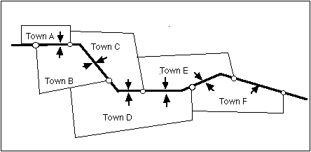
Damage status: ranking shade map based on the report as a city/ward and subdivided town tract (detail report) unit. The damaged number of People (missing, injured), Homes (damaged, flooded, burn out) and Lifeline (power, gas, water, phone) are shaded on the administrative boundary coverage. In the detail report, damaged/recovered sections of the road/river/railway and facility points are displayed.
Recovery progress: The difference between damaged and recovered Lifeline number are shown as a ranking map on administrative boundary coverage.
In addition to those functions, the MIS has a retrieving function to identify the map feature on the screen. The name of the facility and the code can be obtained to retrieve more detail information from database.
An overlay process was treated with the administrative boundary coverage to create sections in the road/river coverage. Each section was assigned tract codes of the both sides that the section is adjacent to or through. The sequential numbers from the beginning section to the end can be illustrated using textural reports containing from/to tract name.
The set of DITs is also able to be stored in each directory/folder on computer disk. Actually to realize individual management for disaster several disk linking each disaster ID were created. This would be helpful to manage historically by changing a storage disk related to time periods.
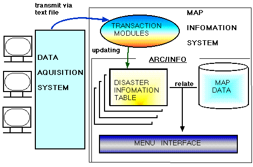
For making rapid updates to the DITs, transaction modules written in FORTRAN were implemented into the MIS. The data acquisition system within DIS collects report data using town/facility name. It also synthesizes a text file that contains town/facility code extracted from the database and damage number/status. The MIS receives the file in a proper time span. Every time when the file is transmitted the modules start their task running within independent ArcInfo sessions. Hence, display task using AML/MENU can see the renewal DITs without waiting the transaction process.
In the indicating the status, RELATE function was adopted to join the DIT with active coverages. The aim to reflect the latest DITs was achieved by changing the direction to be related.
It is necessary, for instance, to maintain the freshness of socioeconomic data that are overlaid with the stricken area polygon for damage assessment. In the detail scale like stage 4, each stricken site location should be plotted in more actual position/area: an application example can be seen in the Disaster Prevention Information System of Tokyo Metropolitan Government using video imagery transmitted from helicopters. If the GPS/GIS running on the hand-held computer is applied, damage sites which are not distinguished from the sky can be gained at the field and sent into the system as quickly as possible.
GIS so far has been capable to view the imagery data. Urban planning and resource management agencies have started to combine vector map data used to be stored and aerial digital photography. For DIS as well, it is expected as the latest and rather cheap source in which decision makers can identify land cover like open space and densely built-up area at a glance. If sets of image data are used, the data store structure should be taken into account to get a tolerable speed because of the volume that might reach to gigabit order for one prefecture.
We should explore the integrated system using GPS, imagery viewing and other state-of-the-art tools surrounding GIS to accomplish comprehensive emergency management decision making.
Okajima,M. et al.(1991)"The Disaster Prevention Information System of Tokyo Metropolitan Government: Disaster Information and ArcInfo", Proceedings of the Eleventh Annual Esri User Conference.
Okajima Masao.(1994)"Application of Digital Aerial Photograph-Aerial Photo Retrieving System (kouku shashin kensaku system)", Journal of Japan Society of Photogrammetry and Remote Sensing, Vol 33, No 4.