The Flight application automates and adds accuracy to the aerial photography process. Prior to the development of this application, photographers and pilots used landmarks and guesswork to determine a flight line's beginning and ending location. This application provides an accurate georeferenced flight path. Pilots, utilizing an onboard GPS receiver, are able to fly the predetermined flight lines. The Missouri Highway and Transportation Department has developed an efficient method of determining and executing an accurate flight line by coordinating GIS and GPS technology.
The Missouri Highway and Transportation Department (MHTD) has been using GIS technology for several years in various projects and applications. The GIS staff consists of personnel from the GIS Section of the Planning Division with programming support from the Information Systems Division. ArcInfo and ARCVIEW2 are used extensively for Planning's activities and to a lesser degree in other MHTD divisions. GIS and its possible uses are quickly being realized by other divisions.
One of the primary sources of information for the department's design operations is aerial photography. Aerial photographs are acquired by pilots of the Equipment and Procurement Division and photographers of the Photogrammetry Section of the Design Division. The flight planning necessary to determine the locations of the flight paths for this photography is very repetitive and time extensive.
The original method of determining the location of the flight path was a manual, inaccurate hit-and-miss process. Lines were drawn on one-half inch to the mile county maps with a ruler and pen. After the lines were drawn the only information the pilots had was a rough location of the flight line on the map. The pilots flew to the site using Variable Omni Range (VOR) or flying to a city or town and following roads. The pilots spent a lot of time getting oriented before the actual photo run was flown.
In 1991, the department's Beechcraft King Air C90 aircraft was equipped with a Trimble Navigation 2000 GPS receiver. A detailed geographic location of the plane was now available to the pilots in flight. The pilots knew where they were located, but did not know the exact coordinates of where they were heading. Once the location was visually pinpointed, they had to circle around and get lined up for the flight. The photographer still had to use visible geographic features such as roadways, creeks and patches of trees to start and stop the camera at the correct location. Flights had to be repeated if the flight path was missed. The need for a precise method of flight path location had become evident to the pilots and photographers.
In 1993, a Yeoman Marine Digitizer Board was acquired and placed in the pilots' office at the airport hangar. This digitizer was simply used as a map georeferencing tool. First, the county maps were taped to the digitizer and registered using at least three known longitude and latitude tic marks off the map. The beginning and ending points of the flight lines were then digitized. The puck was equipped with a liquid crystal diode which displayed the longitude and latitude of a location on the map. The pilots then recorded the longitude and latitude to help them make their photo runs.
This procedure was an improvement over the manual interpretation from a map. However, many flight paths in several parts of the state are photographed during each flight session. Each flight was usually on a different map, and each new map had to be taped to the digitizer before it could be georeferenced and digitized. This process worked well, but eventually developed into a tedious and time consuming process.
In March, 1993, the rains began and the record rainfall continued through the fall. On July 1, 1993, Governor Mel Carnahan declared a state of emergency for many Missouri counties along the Mississippi and Missouri Rivers. By July 15, more than 500 square miles of land were flooded causing the evacuation of 15,000 Missourians.
By July 31, 1993, the flood had claimed 45 lives nationwide, 24 of those from Missouri. More than $10 billion in damage spanned nine Midwestern states. Fifty-nine counties and St. Louis were declared disaster areas. Every previous water level record was surpassed by the Flood of 1993. For example, the Missouri River at Jefferson City, with a flood stage of 23 feet, crested at a record 38.6 feet, 4.4 feet higher than the previous record set in 1951.
By August, roads and bridges started reopening. On August 14, 1993 Route 54 at Jefferson City was reopened because the contractors and MHTD crews worked 12-hour shifts, 24 hours a day. The highway was rebuilt in a record 18 days! By November 3, 1993 all major river crossings in the state were open for the first time in four months.
The Flood of 1993 destroyed everything in the Jefferson City flood plain, including the airport where MHTD pilots were located. The department's planes had been relocated prior to the flood, but the pilots' work area and digitizing equipment were lost. The department temporarily had no method of obtaining the longitude and latitude coordinates to make use of the plane's onboard GPS equipment.
At MHTD, the aerial photo flight season is from December to April while the leaves are off the trees. The pilots were concerned about the upcoming flight season given past timetables and the loss of their office, equipment and records. The department's highway construction program timetable would have to be delayed if the aerial photographs for the reconnaissance and design stages of highway construction were not available as scheduled. The head pilot decided to ask the Information Systems Division programming staff to help expedite the process.
ArcInfo was being used to do analysis of highway data, but no tools for other day-to-day processes had yet been developed. Several library layers of data including waterways, roadways, railroads, bridges, and public land surveys were already in place. The tile structure of the library is based on the county boundaries of Missouri. MHTD uses Universal Transverse Mercator (UTM) coordinate system based geographic data. ArcInfo had the building blocks to develop an application to fill the needs of the pilots.
The solution to the problem was straightforward. Simply project locations from the GIS database coordinate system into longitude and latitude referenced locations. Personnel from the Information Systems and Planning Divisions developed a prototype that was ready to show by the end of the same business day. The prototype was presented to the pilots and proved that GIS could provide the type of coordinate data they needed.
The prototype was created using ARCPLOT. A few layers (county boundaries, state highways and hydrography) of data for Cole county was displayed on the screen. The user was then prompted to select the starting point and ending point of a flight path using the mouse. These two locations were captured using GETPOINT and GETLASTPOINT. They were assigned to variables and then written to an ASCII text file. ARCPLOT was then exited and a PROJECT from the UTM coordinate system to geographic reference locations was performed on the text file. The longitude and latitude values corresponding to the selected points were then written to the display screen.
After reviewing the prototype, the pilots requested the development of an application to generate the longitude and latitude information. The basic underlying algorithm was easy to implement. However, providing the user with an easy-to-use graphical interface was the challenge.
While the prototype application accomplished the task performed by the Yeoman digitizer board, the pilots took advantage of the opportunity to customize the application to their specifications. In order to make flight planning more efficient, the project request included:
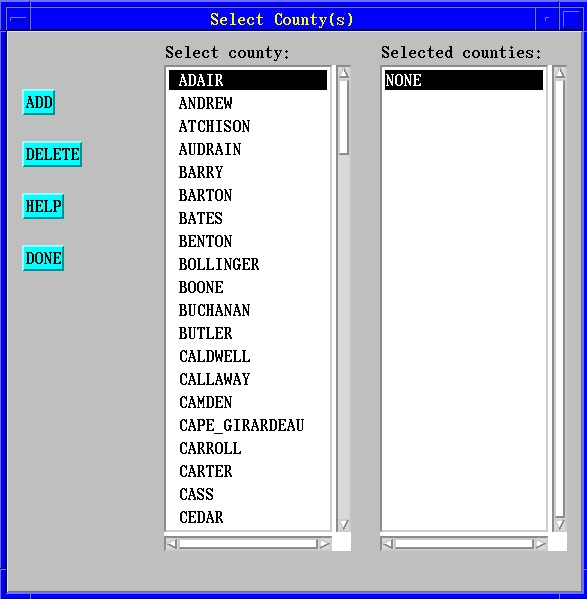
Flight is designed to be operated by the pilots without the support of a knowledgeable ArcInfo user. A UNIX script, executed from the command line, starts up ArcInfo and the menu driven application. Temporary workspaces are created in the user's home directory to allow multi-user access to the application. A county or several counties covering the area of the flight path are selected from a menu displaying the county names. The county name(s) selected are then cross-referenced with the corresponding tile(s) in the map library. After the geographic area is selected, a default display of county boundaries, main hydrography, and the highway network is brought up on the screen. Further customization of the screen with all hydrography and local roads to makes locating the flight paths easier is also available. The highway network has been enhanced with custom shield markersets to make identification of the roads easier.
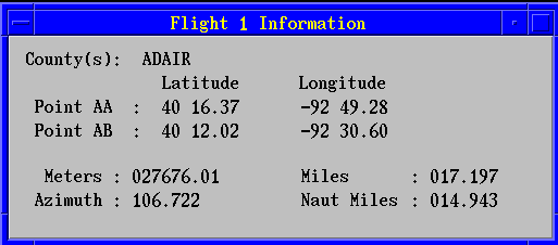
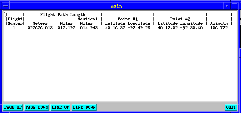
Two types of flights can be planned. One to create a single flight path and another to create parallel flight paths. When creating a single flight path the first and second end points are selected with the mouse. The UTM coordinates are captured and written to an ASCII text file. These coordinates are then PROJECTed into longitude and latitude with the geographic projection option. At this time, several calculations are performed to provide the distance of the flight path in meters, miles, and nautical miles. One mile extensions of the flight path at both ends, and the flight path's azimuth are also calculated.
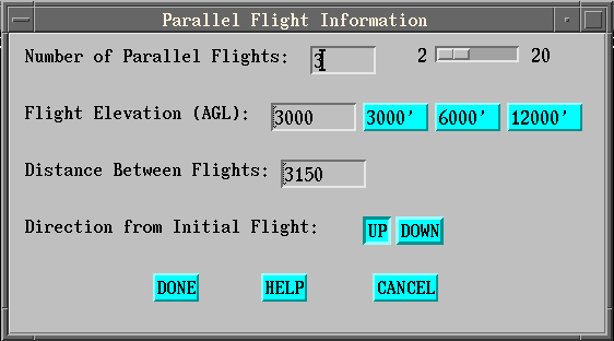
The other type of flight path is a parallel flight path. This option allows the creation of several adjacent, parallel paths. Parallel flights are used when taking aerial photographs of cities or major construction sites. The number of parallel paths, flight elevation, direction from initial flight, and the distance between paths are all available options.
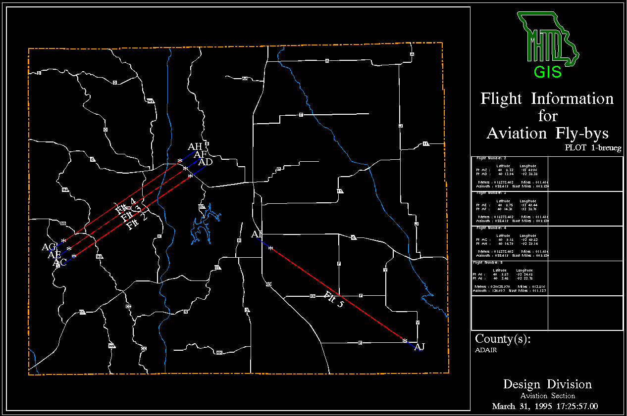
After the flight path processing is complete, the display screen is updated. Flight numbers are labeled on the flight path, the end points are labeled with unique, two- character waypoints and one mile extensions of the flight path are drawn. The calculations are displayed in a pop up menu and added to the map in an information area. The map is sent to a plotter and the pilots receive a hardcopy map with all necessary information for the flight.
Drawing and zooming options are available to customize the map display. At any time, the map on the screen can be plotted and tabular data can be printed. A plot manager to view, replot and delete plots was also added to the application. The plot manager has saved time for the pilots when plotters have gone down or maps were misplaced and need to be replotted.
One of the greatest benefits derived from using the Flight application is the amount of time saved. The pilots can access the application from their desktop instead of commuting to the airport hangar. The need for visual orientation of the flight path is no longer necessary because of the availability of the longitude and latitude points and their onboard GPS equipment. Less flying time generates savings in aircraft fuel costs and the pilots and photographer can accomplish more flight runs in a flight session. It has been estimated that up to $500 a flight session is saved with the GIS and GPS technology.
Users report the Flight application very easy to operate. Flight planning is now a less tedious process. The longitude and latitude points generated by the GIS are more accurate than those previously obtained from the county maps and the Yeoman digitizer board. The proven accuracy of the data has made the starting and stopping of the camera more reliant on the GPS readout than on physical landmarks on the ground. Less time has been spent on repeating flight sessions due to errors in locating flight paths. The availability of parallel flight planning has made the photographing of large areas easier to accomplish due to knowing the exact coordinates of each flight path in the series.
A new version of the Flight application is currently being developed. The aircraft will be equipped with an ARNAV Star 5000 GPS receiver for the 1996 photo season. This new equipment allows the input of longitude and latitude coordinates through a laptop computer connected directly to the GPS unit. The application will be enhanced to generate the longitude and latitude points with greater degree of precision. The data will be written to a floppy diskette in a format readable by the software packaged with the ARNAV GPS unit.
Another feature to be added to the application is a historical view of the flight lines flown during the flight season. After a flight line is generated, it will be added to a coverage for future reference. The pilots will be able to select flight lines and get access to the flight line information previously generated. Flight lines no longer needed can be deleted from the coverage. This enhancement makes the re-flying of a flight path easier with minimal flight processing needed.
ArcInfo has made the flight task easier for our pilots to accomplish and has saved time and money. This application has put the power of ArcInfo into the hands of non-GIS experts and simply adapted the current methodology with new technology. It has stepped over the boundary of GIS and spatial analysis to create a tool that improves the quality of a primary department activity.