Through an innovative joint development project, Merrick & Company, headquartered in Aurora, Colorado, and the City of Glendale, Colorado are developing a municipal geographic information system that is fully integrated with a pipe network hydraulic model of the City's municipal water distribution system. The integrated GIS-Hydraulic Model will be used for interactive evaluation of proposed system changes, and for regular water distribution system management and maintenance.
The City of Glendale's Public Works department has provided water to the residents of this community for many years. Glendale, like many other communities across the country, has found itself faced with increasing demands for water and has sought to implement new technology as a means to more efficiently manage and operate their system.
Merrick & Company is a Colorado-based, full service consulting engineering firm that provides a wide range of services including photogrammetric mapping, GIS development, and public works engineering.
I. INTRODUCTION
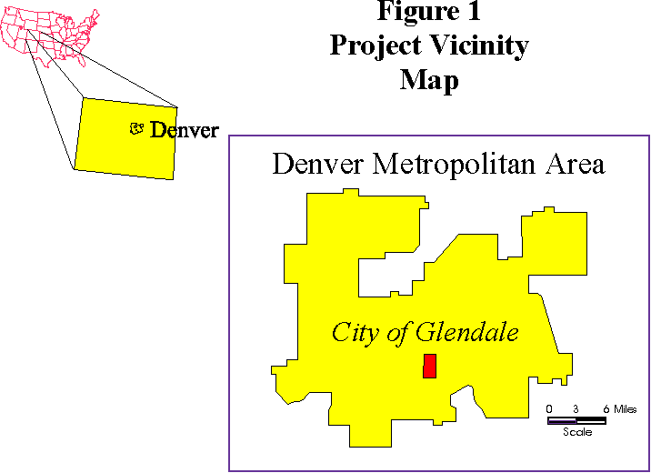
Through an innovative joint development project, Merrick & Company, headquartered in Aurora, Colorado, and the City of Glendale, Colorado are developing a municipal geographic information system that is fully integrated with a pipe network hydraulic model of the City's municipal water distribution system. The integrated GIS-Hydraulic Model will be used for interactive evaluation of proposed system changes, and for regular water distribution system management and maintenance. The City of Glendale, Colorado is a historic part of the Metropolitan Denver Area that is totally surrounded by the City and County of Denver, but is actually part of Arapahoe County. With a total land area of less than 1 square mile, Glendale houses one of the highest concentrations of apartment and multi-family housing in the region. A strong retail and entertainment trade help make Glendale a destination for business and leisure, and it is conveniently located near downtown Denver and the central business district. Figure 1 shows the location of Glendale within the Denver Metropolitan Area.
Merrick & Company is a Colorado-based, full service consulting engineering firm that provides a wide range of services including photogrammetric mapping, GIS development, and public works engineering. Merrick's staff of over 500 people company-wide has expertise in virtually every engineering discipline. In addition, Merrick's photogrammetry and GIS specialists have provided services across the country to communities developing GIS databases for a variety of purposes. The City of Glendale funded Merrick's production of the aerial mapping, GIS database development, and the water distribution system simulation. In turn, Merrick provided the GIS-Model linkage software development. The final result of this joint development effort is a fully integrated GIS-hydraulic modeling application that the City will use to manage their existing system and evaluate future system changes.II. PROJECT OBJECTIVES
Several main objectives were identified for this project. First, the City desired updated planimetric and topographic mapping to replace their existing mapping which had become outdated since its production in 1985. Second, the City required an analytical tool to allow them to quickly evaluate changes to their municpal water distribution system. Third, Merrick & Company desired completion of the development of a GIS-based water system modeling application which was begun as a research and development effort prior to contracting with the City of Glendale. The final objective was to provide the City with a user-friendly analytical tool that did not require advanced training in GIS software to use.III. AERIAL MAPPING AND PHOTOGRAMMETRY
Merrick provided the City with feature painting specifications and control survey guidelines to be used in preparation for the aerial photography. The City arranged for ground control surveying and using City crews, painted all ground features to be captured for inclusion in the GIS. Table 1 contains a listing of the features compiled from the aerial photography. Aerial photography was flown in July 1994 at a scale of 1" = 300'. While foliage was high at that time of year, the commercial nature of Glendale's landscape meant that very few point features were obscured by foliage. Table 1: Compiled Map Features Abbrev. Feature Description ------- --------------------- ADA Handicap Ramps ARV Air Release Valves Bike Bike Paths BL Building Footprints BO Blow-off Valves BV Backwards Valves CONC Curbs, Sidewalks CP Control Points DENVER Denver Water Pipes Drive Driveways EC Pipe End Caps FH Fire Hydrants Fire Fire Service pipes FL Fences, Retaining Walls HY Streams HY Ponds HY Creeks HY Irrigation Ditches HY Culverts LEAD Lead Walks LSS Landscape Point Features LU Land use - playgrounds LU Land use - schools LU Land use - Parks Miscpt Misc. Points MSS Misc. utility poles PARK Parking lots PE Paved Roads PE Unpaved Roads PE Paved Alleys PE Unpaved Alleys PE Trails PE Bridges PO Power Poles PO Light Poles PO Power/Light Poles SS Glendale San. sewer manhole SS Denver San. sewer manhole ST Street Centerlines SW Glendale Stormwater manholes SW Catch basins SW Drop inlets TOPO Index contours TOPO Inter. contours TOPO Spot Elevations TR Cross walks TR Painted lines TR Traffic signs TR Traffic light poles Valley Valley pans VG Vegetation VT Valve vaults WELL Glendale Wells WM Glendale water meters WM Denver water meters WV Glendale water valves WV Denver Water valves WWTP Waste water treatment plant valves Merrick's in-house mapping department performed fully analytical aerotriangulation on the aerial photographs and compiled all visible ground features listed in Table 1. Merrick designed ArcInfo database structures for all mapped features and planimetric feature coverages were produced in ArcInfo. Final map and database editing was performed in ArcInfo.IV. WATER SYSTEM DATABASE DEVELOPMENT
Prior to this project, the City did not have a computer-based facility management system. Their facility information for the water system was completely maintained on hard-copy utility drawings which contained various attribute information such as pipe material, diameters, and valve locations. In order to take full advantage of the information contained on the utility drawings, Merrick digitized the pipe and valve locations from the existing utility drawings including feature attributes for material and diameter. Digitized water valve point features were then used to register the digitized pipe arc features to 359 water valve point features compiled from the aerial photography. Discrepancies between digitized and compiled point feature locations were resolved by careful review of the City's utility drawings and discussion with City staff. The resulting pipe coverage contained 180 individual pipe arc features with material and diameter attributes included in the feature attribute table.V. GIS SOFTWARE AND COMPUTER PLATFORM SELECTION
Some of the main concerns the City had regarding selection of software and hardware for their in-house system were cost, simplicity, and flexibility to allow future growth. Since the City desired to minimize the complexity and costs of hardware and software, a PC-based system was selected. A 486-based PC was chosen as the computer platform for the system. In addition, evaluation of available PC-based GIS packages rapidly lead to selection of ArcCAD from Environmental Systems Research Institute, Redlands, California (Esri) as the preferred choice, primarily due to its direct compatibility with ArcInfo.VI. DATABASE CONVERSION FROM ArcInfo TO ArcCAD
The coverages developed during the mapping portion of the project were created in ArcInfo Version 6.1.1 on a Sun Sparc2 Workstation. These coverages were converted to single-precision export files (.e00) from ArcInfo and were transferred via Merrick's local area network to a 486-based PC running AutoCad Rel. 12c4 for Windows and ArcCAD Rel. 11.3 for Windows. All coverages were imported to ArcCAD via the built-in import function. Successfully importing ArcInfo coverages to ArcCAD involves several steps. The most critical fact to consider is that ArcCAD requires all user -defined feature ID's to be unique. However, this is not a requirement in ArcInfo. The implications of not uniquely defining feature user ID's is that user-defined attribute values will be destroyed if topology for a theme is rebuilt. Before the export files were created in ArcInfo, user ID's for all coverage attribute tables were calculated to equal the record number. This insured that no duplicate user ID's would exist in the attribute tables imported to ArcCAD. Once the coverages were imported, themes were defined in the current drawing file for each class of planimetric features. ArcCAD themes must be defined with a unique feature class, therefore when a coverage contained more than one feature type, multiple ArcCAD themes were required to access all features in the GIS dataset. For example, an ArcInfo Net coverage that contains both arcs and polygons would include an arc attribute table (.AAT) and a polygon attribute table (.PAT). Therefore, two separate themes would be required in the ArcCAD drawing for this coverage, one each for the arc and polygon features. A corresponding AutoCad layer definition was created in the drawing file for each defined theme. The drawing file layer definitions facilitate display of ArcCAD features as AutoCad entities for graphic manipulation and editing. ArcCAD maintains an internal linkage between the GIS feature and its corresponding drawing entity. It is this entity-feature link that is at the heart of ArcCAD's capability for graphical manipulation of geographic data. Maintenance of the correct entity-feature linkage proved to be one of the greatest considerations during the application development phase of this project. Once the themes and layers were defined, selected themes' features were displayed permanently as AutoCad entities. The displayed features provided a graphical background for geographic analyses with the system and included building footprints and annotation, pavement edges, water pipe lines, and water valves. The many other themes' features are only displayed on an as-needed basis. This served to minimize the size of the drawing file and significantly improve overall system performance.VII. APPLICATION DEVELOPMENT: Network Simulation Extension (NSE)
PURPOSE
Merrick named this application the "Network Simulation Extension to ArcCAD" or NSE. This name was selected because the application extends ArcCAD's capabilities to include network modeling, an option that was not available in ArcCAD alone. The primary purpose for developing NSE was to allow an end-user to perform hydraulic model simulations directly from within the ArcCAD GIS. The application was designed to manage the entity-feature linkages for the user, maintain correct topology, and to provide numerous tools to allow the user to change water distribution system components either graphically or by editing feature attribute tables. In addition, the application performs all data retrieval and replacement tasks for the user so that knowledge of the database structures is not required.BACKGROUND
Concurrent with the mapping and database development tasks, work was underway to design custom software to facilitate the seamless operation of a hydraulic network simulation model within ArcCAD. The availability of this type of application was researched prior to undertaking this project. None were available that achieved the objective of operating the hydraulic network simulation by directly using the data from the GIS database tables. Hydraulic simulation models that were investigated included KYPIPE from the University of Kentucky, CYBERNET from Haestad Methods, Inc., and EPANET from the U.S. Environmental Protection Agency. While all of these programs performed the required hydraulic computations adequately, all have unique graphical user interfaces and maintain separate databases for model input which made them less adaptable for use with ArcCAD. KYPIPE was selected as the model for use in this project mainly due to its computational integrity and because of its wide acceptance throughout the engineering industry. Merrick contacted the University of Kentucky to purchase a custom version of their KYPIPE model without the graphical user interface that is usually packaged with the program. In addition, the custom version was re-compiled to support extended memory. This enhancement made the program compatible with the ArcCAD-based modeling application under development.ASSUMPTIONS
Several assumptions were made during program code development. The first assumption was that an NSE workspace has been correctly established. This means that all necessary theme, layer, and block definitions exist in the ArcCAD drawing and that the database structures for feature attribute tables are defined as required by NSE. The next assumption is that the original "as-built" coverages compiled from the aerial photography should be maintained in an "unchanged" condition unless actual changes are constructed and reported by the City. This assumption was made so that the original GIS databases are not be corrupted during "what-if" analyses using NSE.PROGRAM DESIGN
AutoLISP, a programming language within AutoCad, was used for virtually all NSE routines. In addition, many of the routines included in the ArcCAD Extensions to AutoLISP that were packaged with the ArcCAD software were used. These included numerous functions, accessible only through AutoLISP, that made possible access to features, their associated entities, and their attribute data. Feature attribute table structures were designed to match the various input data blocks of the KYPIPE program. KYPIPE's input data is organized in the following blocks: system data; constraint data; label data; regulating valve data; pipeline data; pump data; junction data; output option data; limited pipe output data; limited node output data; extended period simulation setup data; tank data; flow meter data; pressure switch data; and various model change data. Attribute tables were structured with data items of the correct size and type to match each item required by KYPIPE. Input data blocks that had no features associated with them, such as EPS setup data, were maintained as record themes in ArcCAD. Record themes were created to store non-graphic data required by the KYPIPE model. Table 2 below lists all the model-specific themes and a description of their purpose. Table 2: NSE Theme Definitions Feature Theme Class Description ------- ------ ----------------------------------------- EPSDAT Record Setup data for Extended Period Simulation EPSTANK Point Point features for water tanks/reservoirs FH Point Fire hydrants FIRESVC Arc Fire service pipes to buildings FN_LUT Record Fixed Grade Node Number look-up table JN_LUT Record Junction Node Number look-up table NODE Point Hydraulic model nodes LU Poly Existing Land use polygons NODE_LUT Record Model Node number look-up table PIPE Arc Water distribution system pipes PNUM_LUT Record Pipe number look-up table PRSWTCH Point Pressure switches for EPS PUMP Point Pumps - Inline SERV_AREA Poly Water Service Area Polygons SYSDAT Record System data for model run TITLE Record Model title records for current simulation VALVE Point Water system valves VALV_LUT Record Valve number look-up table WELLS Point Glendale supply wells WM Point Glendale water meters WTRSVC Arc Glendale water service lines to buildings Maintenance of the hydraulic model's pipe connectivity was essentially handled by ArcCAD. However, additional attributes were added to the pipe feature attribute table to allow a fixed, model from-node and to-node label to be assigned for each pipe. ArcCAD's internal from- and to- nodes that are defined in the arc-node topology change many times as the theme is modified and topology is rebuilt. The apparent redunduncy of a separate from- and to- node label attribute for each pipe was necessary because modelers need to have a way to uniquely identify a specific water system component by the same label or ID number for all analyses. Several global routines were written to handle repetitive tasks required by all of NSE's functions. Examples of these repetitive tasks include: rebuilding a theme's topology after a system component location change; re-displaying a theme's features as drawing entities to re-establish the entity feature links; and filtering the drawing entity database to isolate a particular type of entity after a user point pick selection. Much of the complexity of NSE's functions is required to maintain ArcCAD's dual databases. Any operation that modified a displayed features' entity location requires updating both the GIS dataset for the theme and re'displaying' features to re-establish entity feature linkages. However, attibute-only changes to a feature can be made in the appropriate feature attribute table without modifying the drawing entity database. Four main categories of functions were developed for NSE. These are: functions for adding new system components such as pipes or pumps; functions for editing or removing existing components; simulation model setup functions; and results evaluation functions. NSE functions make extensive use of AutoCad's programmable Dialogue Control Language (DCL) to provide the user with familiarly formatted dialogue boxes for data input and editing. This gives the finished application the familiar look and feel of all the other AutoCad and ArcCAD dialogue panels. Figure 2 shows a typical NSE dialogue box for data display and attribute editing.
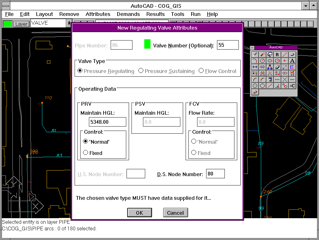
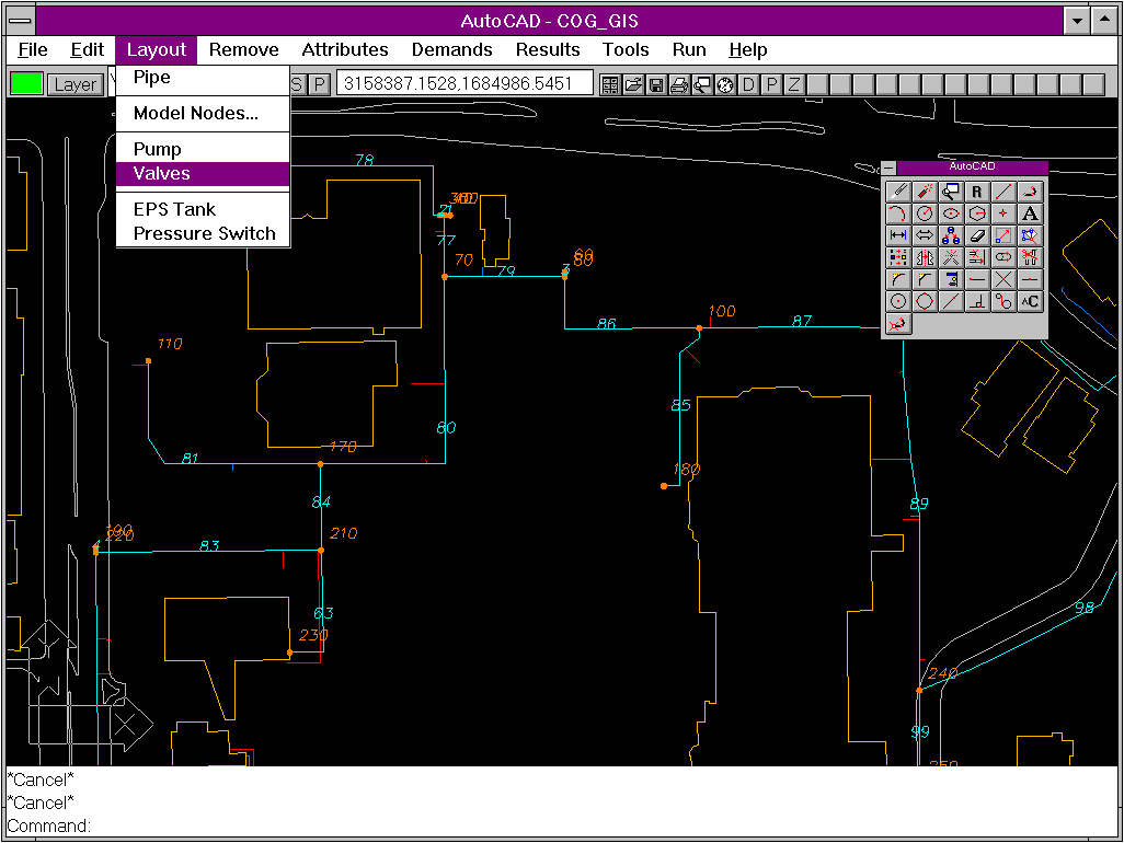
Figure 3 shows the NSE menu bar as it appears inside ArcCAD.  All NSE

functions are accessed via AutoCAD's standard pull-down menu

interface.  The NSE application is accessed from an additional menu

selection from ArcCAD's Analysis menu item.
Input data for a model simulation is retrieved from the attribute tables primarily using ArcCAD's DBDUMP function. NSE retrieves data items for each pipe and system component, orders them as required by KYPIPE, and dumps the information to an ASCII formatted text file. KYPIPE then reads this file as input for a simulation. In the same way, NSE reads KYPIPE output data from an ASCII file and places model results for pipes and nodes in output tables. These output tables are then accessed by NSE's output display functions to either display graphic results on-screen or print tabular reports. Example output display functions include: pipe flow directions; coloring pipes by user-selected parameter such as velocity or flow rate; and labeling node pressures. In addition, all of ArcCAD's built-in query functions are available to the user to perform unlimited combinations of queries.WATER SYSTEM DEMAND GENERATOR
One of the most time-saving capabilities of NSE is automated computation of water system demands. NSE incorporates a demand- generator that intersects a land use polygon theme with a water service area polygon theme to compute system demands based on land use. This allows a user to change land use attributes such as population density and per-capita water use under average day and maximum day conditions via a dialogue box. Using the new attributes, NSE computes system demands at each model node automatically. Then, a simulation can be run to quickly evaluate system impacts under the new demand conditions. This capability provides the modeler with an efficient way to evaluate a wide variety of demand scenarios, all within the GIS environment.PROGRAM DEVELOPMENT LIMITATIONS
Developers and users will encounter several limitations when creating applications in the ArcCAD/AutoCAD environment. Most noticable are the inherent limitations of the AutoLISP language. Since AutoLISP code is interpreted, debugging is a slow process. Several after-market tools have been developed to aid in the code creation and debugging process, however it can still be very time consuming. AutoCAD's Dialogue Control Language (DCL) presents another set of challenges to developers. This is a format-sensitive language and a much care must be taken when creating applications that employ interfaces created with DCL. Dialogues created with DCL experience unexpected changes when moved to different platforms. Dialogues developed on one machine may appear differently on another. This characteristic forces either a machine-specific application development or extensive testing if the end platform is not known. NSE's dialogues have been designed for compatibility with a variety of platforms and to appear consistently from one platform to the next. The functions packaged with ArcCAD as the Extensions to AutoLISP are very useful and sometimes indispensable to developers. However, the functions are extremely sensitive to correct syntax. Many of these functions require that all arguments be passed as character strings. Therefore, frequent type switching from integer and real to character string format is necessary. This is generally rather inefficient and can be a source of numerous errors.VIII. NETWORK MODELING
Merrick's agreement with the City provided for development and calibration of an existing-conditions model of the water distribution system. The City provided water utility billing data that contained actual water use by account for a period of two years prior to this study. Initial demand estimates were made after studying existing land uses and analyzing the water utility billing information provided by the City. Model calibration was accomplished using hydrant test data provided by the City. This information consisted of flow and residual pressure measurements at numerous hydrant locations throughout the City. These measurements were compared to model-calculated flow and pressure data. Adjustments were then made to pipe roughness coefficients (Hazen-Williams C) and to estimated system demands until observed test values were acceptably reproduced. The calibrated model will be used in future analyses to evaluate proposed system changes due to new development, replacement of equipment, and conversion from the existing well water supply to a direct pipeline connection to the City of Denver's system. NSE's functions proved very helpful in quickly developing and analyzing the City's water system. Running additional simulations during the calibration process and making changes to parameters for individual system components is made a simple task by the tools that have been developed.IX. PROJECT SUMMARY
The objectives of this multi-purpose project were to provide the City of Glendale with a state-of-the-art GIS database containing virtually all visible planimetric features. In addition, development of an initial water distribution system model to serve as the basis for future evaluation of the City's system was required. Creation of customized software to completely integrate the modeling functions as an extension of the capabilities of ArcCAD was intended to allow the City to perform analyses of the impacts on the water distribution system from proposed developments. Keeping the system PC-based would allow the City to begin working with GIS for minimum initial cost. Through the course of this project, some of the original visions for the ultimate use of the GIS databases and the NSE applications changed. Due to budget and staffing constraints, the City of Glendale decided not to bring the entire system in-house as originally planned. This decision was made primarily because the City's Public Works department functions with a relatively small staff. Existing responsibilities and other time commitments of staff members made taking on the additional tasks of GIS database administrator and water distribution system analyst infeasible. Instead, the City decided to retain Merrick & Company to store their databases and provide on-going support services for GIS analyses and engineering. Merrick will provide services to the City on an as-needed basis and will perform various analyses for many of the City departments using the City's GIS. In addition, Merrick will perform water distribution system analyses as they are needed in the future. Updates to the City's GIS are already under way, necessitated by the continued development and growth that has occurred. As funding and staff resources become available, the City may again pursue bringing their GIS in-house. Merrick & Company is continuing development of other custom applications for specific client needs. NSE provides an excellent tool that can be easily applied to other cities systems to efficiently use data stored in their GIS to analyze their water distribution systems. And, through the insights that were gained from this project, many new ideas have come for cost-effective ways of integrating GIS technology into engineering applications.X. RECOMMENDATIONS
ArcCAD presents a very viable alternative to organizations that want to develop GIS capabilities without the hardware and software expenses associated with implementing ArcInfo on a workstation. ArcCAD's compatibility with ArcInfo allows easy integration of ArcInfo databases. This gives an organization flexibility in obtaining data and constructing databases. Because ArcCAD operates inside AutoCAD, users untrained in UNIX and ArcInfo systems can get "up-to-speed" quickly, thereby reducing training costs when compared with other systems. The AutoCAD environment lends itself well to development of custom applications that can access the functionality of ArcCAD's GIS tools. This accessibility can allow an organization to make greater use of the databases they have invested in. Through joint venture projects like this, Cities can receive added value from their investment in database development and GIS technology to maximize benefits gained. By working with Merrick & Company, the City of Glendale has developed a sophisticated GIS and engineering tool that can serve as the foundation for future management of the City's resources. As technology continues to advance, Glendale's approach to this project will position them very well to make best use of limited resources while keeping up with technology.REFERENCES
ArcCAD Programmer's Guide. Environmental Systems Research Institute, Inc.,1992. Wood, Don J.. KYPIPE 2 User's Manual. Civil Engineering Software Center, College of Engineering, University of Kentucky, Lexington, KY, November 1991. AutoLISP Programmer's Reference Manual. Autodesk, Inc., 1992. AutoCAD Customization Manual. Autodesk, Inc., 1992. AutoCAD Advanced Tools. Autodesk, Inc., 1993. Walski, Thomas M.. Analysis of Water Distribution Systems. New York: Van Nostrand Reinhold Company, 1984. Hampe, Kurt et. al.. Killer AutoCAD Utilities. Indianapolis, IN: New Riders Publishing, 1993. Using AutoCAD Release 12. Que Development Group. Carmel, IN: Que Corporation, 1992.
John D. McLaughlin, P.E.
GIS Applications Engineer, Merrick & Company
2450 South Peoria Street
Aurora, Colorado 80014
Telephone: (303) 751-0741
Fax: (303) 745-0964