Nobuko NAKAMURA, Yuzuru KIKUCHI, Seizaburo ABE
The GIS is widely applied for forest management purposes in Japan recently. We already have developed a Forest Management Database that is covering about 150,000 hectares of forest areas in the Chiba Prefecture. Our new project has been started as an extension of the Forest Management Database project to properly analyze the function of the forest areas. The existing forests are not only important as materials but also very essential for the human beings and for the environmental protection.
The project area was selected for the evaluation methodology for the Forest Management System and following analyses were conducted:
(i) Location of the forest areas responsible for rain water storage,
(ii) Identifying the forest areas capable for wood production, and
(iii) Locating the forest areas suitable for recreation planning.
The final result maps were produced depicting the different forests rankings. The above outlined analysis established the model for evaluation and methodology for the Forest Management System.
Forests play a major role in supporting the life of mankind. For example, supplying timber, storing water, preventing landslides or debris flows, providing protection from strong winds and purifying the atmosphere. Recently, people have come to appreciate forests not only as a source of timber, but as a place where contact with nature can be enjoyed. That is to say, the recreational possibilities offered by woodlands have gradually come to be recognized.
In Japan, the increase in imports of foreign timber has been accompanied by a fall in domestic prices, and a growing shortage of forestry workers and increase in their average age has led to a stagnation in timber production activities. As a result, the number of forests left to deteriorate is tending to increase. Generally in Japan, forests are divided into managemental units or compartments, that are further subdivided into subcompartments and managed using registers. In the register is recorded the area, types of trees, soil and other information with respect to each managemental unit.
However, in order to improve the current condition of forests and manage them, it is necessary to obtain a firm grasp of the location of forests in need of maintenance or conservation. To achieve this, Geographic Information System (GIS) technology is needed to effectively manage both the geographic information and register information.
This report describes efforts taken to produce a method for making a functional evaluation of forests using GIS technology.
Chiba Prefecture is located to the east of the Tokyo metropolitan district. The total area is approximately 515,000ha. The northern region of the prefecture is mainly plains, the southern region being formed from 200m~300m hills. Suburban farming flourishes in the prefecture which boasts third place nationwide in terms of agricultural produce.
Nevertheless, the north-west region is a metropolitan suburb, with economic development and urbanization progressing at a rapid pace. About 80% of the prefectural population lives there. With the progressing urbanization has come land development for large scale projects and disorderly developments that continue to reduce the amount of forest land. Also, with the increasing imports of foreign timber and labor shortages, the future of the remaining forests is in danger.
In response to the above mentioned problems, in 1993, the Enterprise for the Maintenance of Forest Basins was set up in Chiba Prefecture with the aim of maintaining and preserving these forests. Of the 158 national planning districts, the Chiba forests come under two planning districts, one for the northern region and the other for the south. Furthermore, in order to take full advantage of the potential of the forests, the forest areas are further divided into 11 subbasins for their planning and management. In Chiba Prefecture in 1987, prior to the setting up of the enterprise, the ArcInfo system was introduced, and a GIS database formed, based on Chiba's forestry information.
Using this database, an analysis was made of timber resources and status of the timber production infrastructure, the forest watershed protection function and condition of forest maintenance, the comprehensive use of the forests, and conditions of the local forest habitat. During the current year, an initial trial was carried out in an effort to evaluate the forests of two of the 11 subbasin areas.
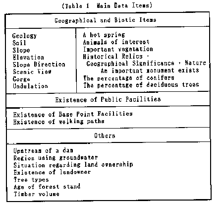
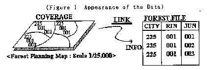
In Chiba Prefecture, the forestry management is administered not only with regard to the managemental units of compartment and subcompartment, as was described above, but uniquely uses the managemental units of compartment, semi-compartment and subcompartment. The database, as shown in Figure 1, is composed of attributes based on the register information, and local maps of the various semi-compartments. The semi-compartments were stored in the database at a scale of 1:25,000, each with about 30,000 polygons. As the subcompartments are minute maps, they are not included in the database. The attributes, based on the register information, are updated annually. The main items are shown in Table 1. In addition to the items listed in the table, there are coverages on 136 forestry related items stored in the system.
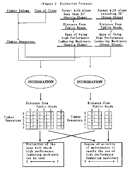
This analysis evaluated the forests in terms of their timber production potential (Figure 2). To make the most effective use of timber resources, if the distance from nearby roads was short, and the timber resources were abundant, the forest was considered a "high timber potential forest". Firstly, in computing the magnitude of the timber resources, the types of tree and timber volume were integrated. Considering the types of tree, those types useful as timber (cedar, cypress etc.) were given a high rating value. A rating value for the timber volume was also applied. Next, the slope determined the type of machinery that could be brought in and used, so the forests were divided into those having a steep slope and those with a gentle slope. Also, in order to determine the ease with which forestry equipment could be brought in, the distance from available roads was evaluated. Finally, all of the various values were integrated and the results were organized into five ranks.
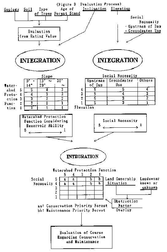
This analysis was performed to evaluate the latent function of the forest in restraining headwaters, and to evaluate also the level of requirement for this function. In other words, the ability of the forest to store water i.e. reservoir ability, and the location of the forest, were evaluated with respect to the social necessity (Figure 3).
In evaluating the reservoir ability, factors such as the geology and soil, category of forest, age of forest stand, and steepness were used. The elevation of the forest location, whether or not the forest lies upstream of a dam or in a region where groundwater is used, were factors used for the evaluation of the social necessity. Particularly in cases where the forest lies upstream of a dam or in a region where groundwater is used, a high rating value was ascribed. Finally, the factors for reservoir ability and social necessity were integrated. Of the forests that rank highly in social necessity, those having a high reservoir ability evaluation were made "conservation priority forests", and those having a low reservoir ability evaluation are made "maintenance priority forests". To determine the obstruction factor with regard to conservation or maintenance, forests for which the location of the landowner is known and those for which the location of the landowner is not known were differentiated by overlay process.
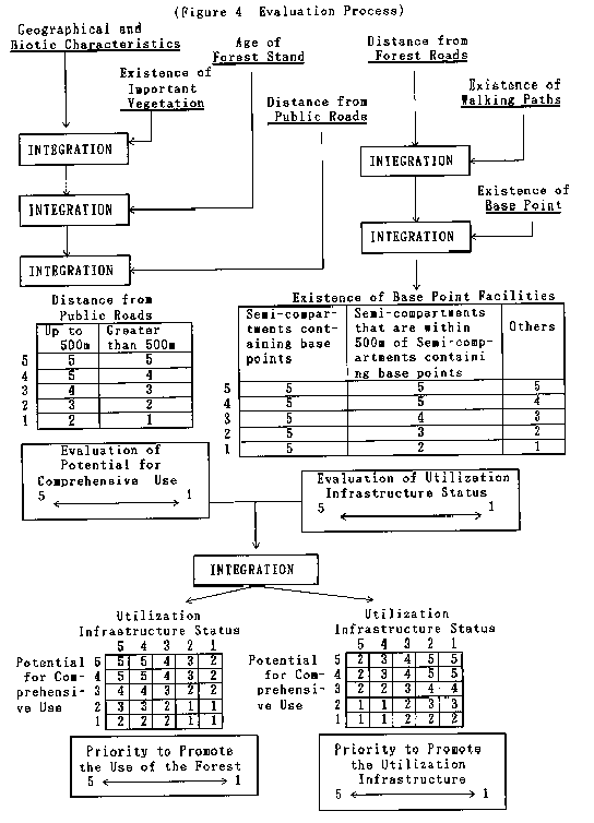
This analysis was used to evaluate the comprehensive use (recreation, health, culture etc.) of forests. This particular function of the forest is of special importance in Chiba, as the forests lie within a distance that enables day trips for people living in the suburbs of Tokyo. For this evaluation, as the uses of the forests are multifarious, there are many items that enter into the reckoning (Figure 4). The items to be evaluated can be divided into the following four major categories:
(i) Geographical and biotic characteristics
(ii) Distance from roads/accessibility
(iii) The existence of public facilities
(iv) Vegetation
Firstly, the items to be considered in evaluating the geographical and biotic characteristics include, "whether the scenery is pleasing or not", "whether or not there is a valley", "whether there is an abundance of fauna and flora", "what percentage of the trees are coniferous". These factors are conditions related to the nature and location of the forest (Table 1: Geographical and Biotic Items).
In particular, forests having important vegetation or an old forest stand were given a high rating value. This was because a gorge with old and magnificent trees was considered more suitable for the needs of comprehensive use than a forest with young growth. Forests that were located relatively close to public roads (less than 500m) were adjusted to a higher rating value. These values were used to make the evaluation of the potential for comprehensive use of the forest.
The existence of public facilities (camping grounds, forest roads etc.) was then evaluated. The rating value resulting from the existence of these facilities was used to evaluate the usage infrastructure status.
The respective rating values for the potential for comprehensive use and the utilization infrastructure status were then integrated. If the rating for the potential for comprehensive use of the forest is high and the utilization infrastructure status of the forest is also high, then this forest is highly valued as a forest suitable for comprehensive use, and this also indicates the existence of substantial public facilities. In other words, the "priority to promote the use of the forest" is high. On the other hand, if the potential for comprehensive use is high but the utilization infrastructure status is low the forest is evaluated as a forest suitable for comprehensive use, but means that there is a lacking in the infrastructure provided for making use of the forest. For this reason, it is considered that the "priority to promote the usage infrastructure" is high.
By expression using maps, the current condition of forests, and the location of forests in need of maintenance were immediately recognized. Three evaluation results were described. In the case of forests which are ranked as high timber potential forests and at the same time have high reservoir ability, there is a need to study whether the forest should be preserved for the headwater restraining function or should be exploited for the lumber. Also, forests that have a high ranking both in terms of their high timber potential and their suitability for comprehensive use, have to be studied to determine how they best be used. These problems have to be considered taking into account the condition of the surrounding forests, and a comprehensive judgement formed, based on the results of the three evaluations. For this reason, it is felt that the use of GIS to form these evaluations was effective.
However, the procedure carried out to perform the evaluations was a first time trial, so setting of rating values or establishment of evaluation items were established on a trial-and-error basis. Therefore, there are many points that need improvement before the results can be used in actual forest planning studies.
By re-evaluating the points needing improvement, this evaluation method will be arranged to establish a technique to construct a system for the evaluation of forests. If the evaluation items and rating values that were determined by trial-and-error being freely chosen, characteristics other than timber production, or forest headwater restraining function, will be evaluated. Also, it is necessary to update the data used in the evaluation, to keep abreast of changing forest information. How to effectively manage and maintain the database is also an important issue requiring attention.