This study is part of an assessment of water supply needs and sources in which the St. Johns River Water Management District (SJRWMD) has been required to identify areas expected to have inadequate water resources to meet the future water supply demand in the year 2010. The approach to this assessment was to utilize regional ground water flow models and local analytical ground water flow models to evaluate the effect of increased pumping on the ground water flow system. To ensure the adequate placement of the locations of current ground water flow models and delineate areas where new analyses should be performed, a GIS methodology was developed using an overlay procedure with gridded surfaces to identify areas that have a high potential for (1) vegetative impacts, (2) saltwater intrusion, and/or (3) an increase in public water supply demand. Eight thematic grids were created, each of which bears some relational aspect to the three potential hydrologic impacts considered. The grids consisted of eight hydrologic, demographic, and vegetative surfaces. Based upon the distribution of the data and the hydrology, the data within each grid were weighted from 1 to 5, where 1 represented the least significance in causing or contributing to one of the three areas of evaluation, and 5 represented the greatest significance in causing or contributing to one of the three areas of evaluation. Each of the grids were weighted against each other based upon how each factor influenced the impacts being evaluated in the study. The designated weights were multiplied by each grid, then all of the grids were added together to produce a final grid of scores. The boundaries for the seven regional ground water flow models and the large public and private water utility service areas were overlaid on the final grid. The results confirmed that the locations of the ground water flow models were consistent with the results of this analysis. This information will also be used to identify areas where future analyses need to be performed.
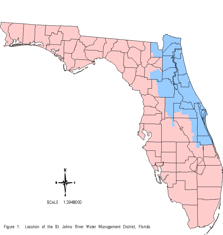
The St. Johns River Water Management District (SJRWMD), located in northeast Florida, along with the other four water management districts in the state, was charged by the state legislature to perform a needs and sources assessment of current and future water supply demands. Within the over 12,000 square miles of SJRWMD, ground water is the preferred source for public, agricultural, and industrial water supply. Ground water is primarily derived from the Floridan aquifer, which is a semi- confined limestone aquifer that extends from southeast South Carolina, southern Georgia, and southern Alabama through Florida. Current ground water use for the 4,638,000 people in SJRWMD is 1,090 million gallons per day (mgd), and ground water use is projected to increase to 1,490 mgd by the year 2010.
Florida Administrative Code and Florida Statues require water management districts in Florida to identify “specific geographical areas that have water resource problems which have become critical or are anticipated to become critical within the next 20 years.” SJRWMD is assessing water supply needs and sources using regional numerical ground water flow models and local analytical ground water flow models to project which areas are expected to have inadequate water resources to meet the anticipated water supply demand in the year 2010.
To ensure adequate placement of the locations of the regional and local ground water flow models and to identify areas were future work may need to be performed, SJRWMD completed a study, using a geographic information system (GIS) methodology, parallel to the ground water modeling that identifies areas having the potential for public water supply problems. The study discussed in this paper details the methodology and results using a GIS approach to identify areas having a high potential for (1) vegetative impacts or changes, (2) salt water intrusion, and/or (3) an increase in public water supply demand.
The study area covers the entire SJRWMD. SJRWMD includes all or part of 19 counties in northeast Florida, extending from the Florida-Georgia state line in the north to Vero Beach in the south. The eastern border of SJRWMD is the Atlantic Ocean, and the area of jurisdiction extends as far west as central Florida. Wetlands, lakes, and springs are important features of the landscape; however, they are not persistent and are dispersed throughout SJRWMD. Land surface elevations change from 0 feet above mean sea level (msl) to approximately 310 feet msl.
The hydrogeology and other related parameters that would affect public water supply problems vary significantly throughout SJRWMD. The hydrogeology typically consists of a surficial aquifer, a semi-confining unit, and the Floridan aquifer, which is the primary source of water supply. In some areas the surficial aquifer is productive enough to be a source for public water supply, and in other areas the surficial aquifer is non-existent. The hydrogeology also varies from regions where no confining unit is present to regions with a confining unit many hundreds of feet thick. The Floridan aquifer, in some locations, is near land surface and in other locations it is at depths of 500 to 1,000 feet. Chloride concentrations vary from no potable water through the entire Floridan aquifer to very good water quality. The decline in the elevation of the potentiometric surface of the Floridan aquifer varies in SJRWMD based upon the hydrogeology and amount of new withdrawals in the last 10 years and the aggregation of withdrawals over the last 50 years.
The GIS platform that was used consisted of a SUN Sparcstation II using SunOS 4.1.3 (UNIX), running ArcInfo 6.1.1 (Esri, 1992). Much of the work completed on the project was done via an X-Windows connection between a local personal computer and a workstation.
The methodology essentially was an overlay procedure in the GRID module of ArcInfo. Boniol et al. (1993) determined that a 380-foot cell size provided a good calibration between the actual and simulated 1990 potentiometric surfaces; therefore, all the grids were created with a grid cell size of 380 feet.
Eight surfaces were created, each relating in some way to (1) vegetative impacts, (2) salt water intrusion, and/or (3) increases in public water supply demand. Based upon the distribution of the data and the hydrology, the data within each grid were weighted from 1 to 5, where 1 represented a factor having the least affect on the impacts being evaluated and 5 represented a factor having the greatest affect on the impacts being evaluated. The grids also were weighted against each other on the same scaling system, from 1 to 5, based upon the interrelationships among the grids which would influence the impacts being evaluated in this study. Each grid was multiplied by the designated weight, then all of the grids were added together to produce a final grid of scores.
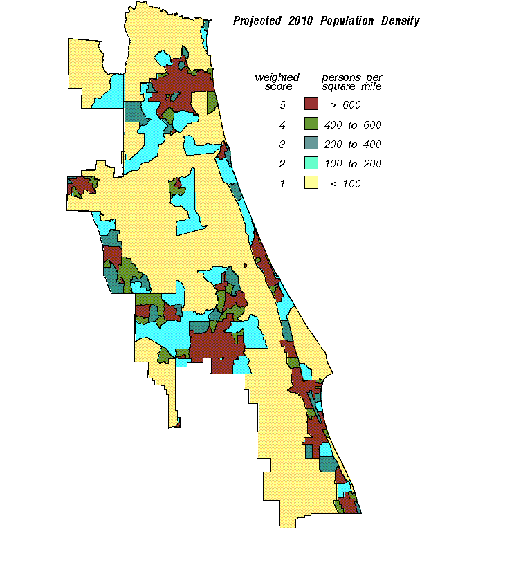
The surfaces used in this project consisted of (1) long-term decline in the potentiometric surface of the Floridan aquifer, (2) short-term decline in the potentiometric surface of the Floridan aquifer, (3) confining unit thickness over the Floridan aquifer, (4) vertical head difference between the Floridan aquifer and the surficial aquifer, (5) percentage of fresh water in the Floridan aquifer, (6) horizontal distance to areas of no potable water in the Floridan aquifer, (7) wetland locations, and (8) projected 2010 population density.
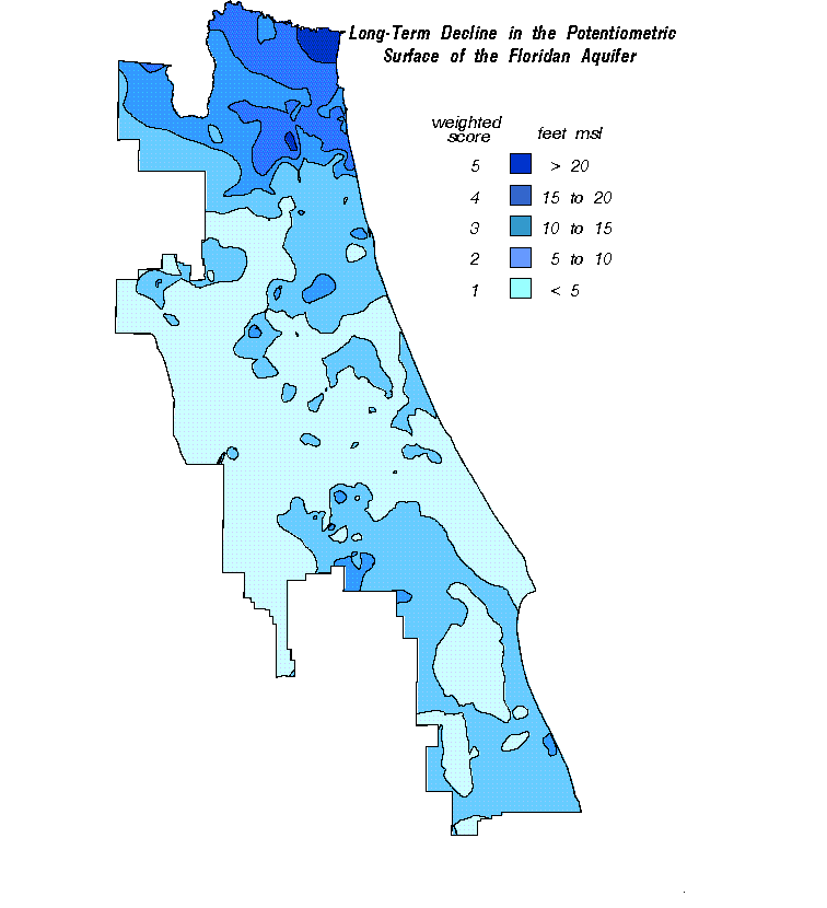
This surface represents the long-term change, entirely in the form of decline, in the water level of the Floridan aquifer. This grid was selected to represent the overall decline in the potentiometric surface of the Floridan aquifer due to long- term development in SJRWMD, from 1936 to 1990.
The predevelopment surface, created primarily from 1936 data, was a U.S. Geological Survey (USGS) contour map (Johnston et al., 1980) where the contours represented the potentiometric surface of the Floridan aquifer in feet above mean sea level. The map was digitized into the GIS. The coverage was processed through the triangulated irregular network (TIN) module, then through the GRID module to create the final grid representing the predevelopment potentiometric surface of the Floridan aquifer.
The 1990 potentiometric surface of the Floridan aquifer (Boniol et. al., 1993) was similarly created and used previously as part of the SJRWMD recharge project. This surface began originally as a point coverage of monitoring well water levels from May 1990. The point coverage was processed through the TIN module and then the GRID module to create a grid of the 1990 potentiometric surface of the Floridan aquifer.
The final surface was calculated by subtracting the predevelopment potentiometric surface grid from the 1990 potentiometric surface grid. This procedure produced a surface showing the amount of long-term decline in the potentiometric surface.
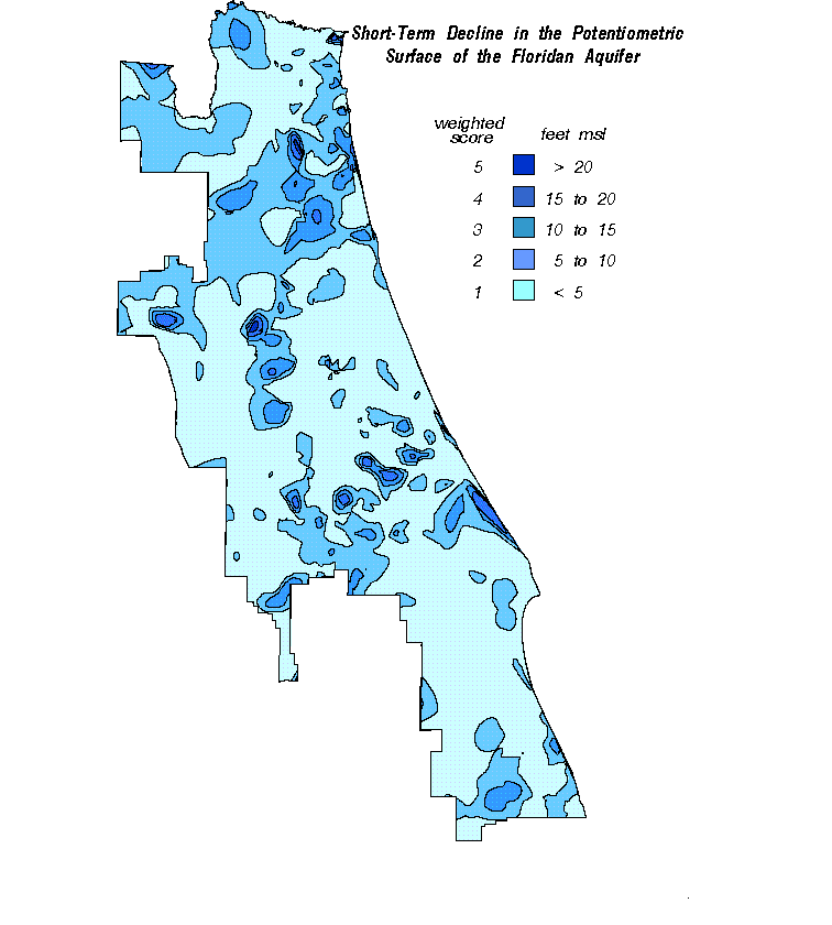
The short-term decline in the potentiometric surface grid represented the change in the water level of the Floridan aquifer from 1980 to 1990 caused by recent economic development and the associated increase in water supply demand in SJRWMD.
The 1980 potentiometric surface was created using monitoring well water levels from May of 1980. The coordinates and water levels of the well points were used to create a point coverage. A TIN surface was created from the point coverage and a grid surface was created from the TIN surface using the ArcInfo GRID module. The 1990 potentiometric surface, previously described, was again used in the analysis. The 1980 potentiometric surface grid was subtracted from the 1990 potentiometric surface grid to create a grid showing the short-term term decline in the potentiometric surface change of the Floridan aquifer.
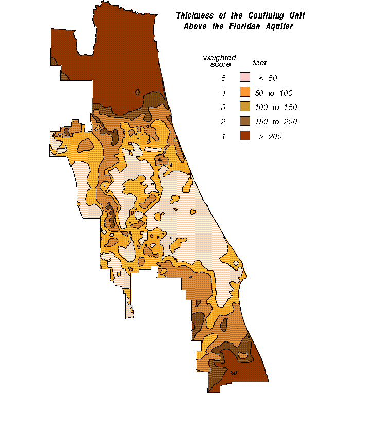
This surface represents the amount of confining material through which water flows that is recharging to or discharging from the Floridan aquifer. This surface is important for determining vegetative impacts. The thicker the confining unit, the less induced drawdown that will occur in the surficial aquifer due to pumping in the Floridan aquifer. The less induced drawdown in the surficial aquifer, the fewer vegetative impacts.
The thickness of the confining unit surface also was used as part of the SJRWMD recharge project (Boniol et al., 1993). The initial coverages were compiled by evaluating geophysical logs throughout SJRWMD to determine the top of the confining unit and the top of the Floridan aquifer. Both of these coverages were processed through the TIN module and through the GRID module. Then the top of the confining unit was subtracted from the top of the Floridan aquifer to obtain the thickness of the confining unit above the Floridan aquifer.
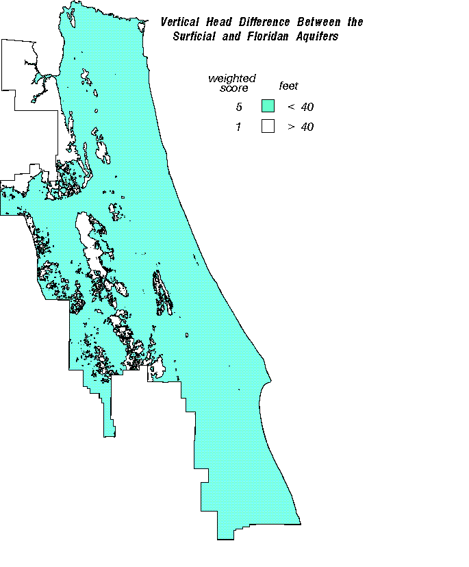
The vertical head difference shows the pressure difference between the surficial and Floridan aquifers. This pressure difference is significant, as it is a factor controlling the amount of water being recharged to or discharging from the Floridan aquifer, as well as the amount of upwelling of poor quality water in the Floridan aquifer. Areas with a high positive vertical head difference provide very good recharge to the aquifer; however, vegetative impacts can be significant because of the continual drainage of water from the surficial aquifer. Areas with a high negative vertical head difference are susceptible to salt water intrusion, because they are discharge areas where water is upwelling from the lower saltier portion of the Floridan aquifer to the upper portions of better water quality.
The vertical head difference grid was created originally for use in the SJRWMD recharge project (Boniol et al., 1993). Two grids were used to create the vertical head difference grid. The first grid was the 1990 potentiometric surface grid already discussed above. The second grid was a grid of surficial aquifer water levels. To create the surficial aquifer water level grid a regression equation (Y= 0.901x - 1.61) was used showing the relationship between land surface elevation and the depth to the water table. A grid of hypsography was then processed through the regression equation to create a depth to the water table surface. The depth to the water table was subtracted from hypsography to yield elevations of the surficial aquifer. The 1990 potentiometric surface grid was subtracted from the surficial aquifer water level grid to produce the vertical head difference between the surficial and Floridan aquifers grid.
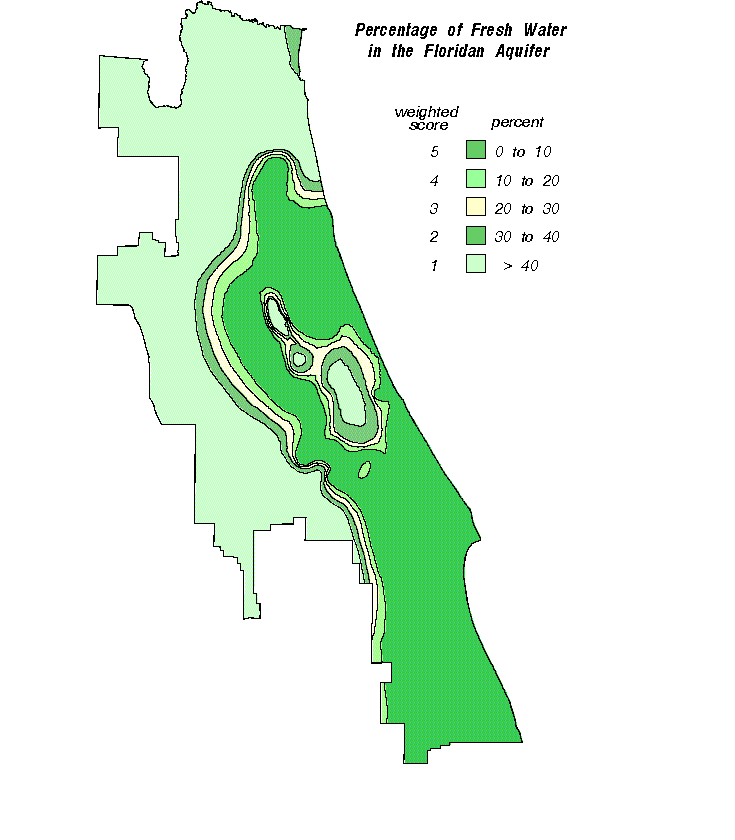
The Floridan aquifer, in some locations, is greater than 1,000 ft thick; however, not all of the water in the aquifer is potable. Potable water is defined as water containing chlorides or sulfates less than 250 milligrams per liter (mg/L), with a total suspended solids (TDS) concentration less than 500 mg/L. The percentage of fresh water grid indicates how much of the water in the Floridan aquifer is actually potable relative to the thickness of the aquifer.
To produce this surface, first a coverage was produced showing the thickness of potable water in the Floridan aquifer. Causey and Leve (1977), of the USGS, prepared a water quality map that was used as a base map for this surface. The map was digitized into the GIS and the contours were then edited based upon current information from ground water flow models, monitoring wells, and time-domain electromagnetic (TDEM) studies. A TIN surface was created from the contours, then a grid surface was created from the TIN surface. The grid surface was evaluated to ensure it matched the edited contour coverage.
A map showing the total thickness of the Floridan aquifer was digitized into the GIS from Miller (1986). This contour coverage was processed through the TIN module, then through the GRID module to produce a grid representing the total thickness of the Floridan aquifer.
To calculate the percentage of potable water in the Floridan aquifer, the following equation was used: (thickness of potable water MINUS total thickness of Floridan aquifer) MULTIPLIED BY 100 DIVIDED BY total thickness of Floridan aquifer
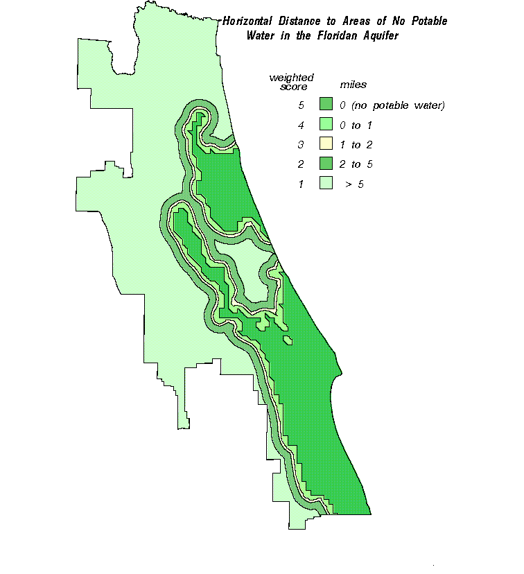
This surface was selected to give credit to those areas far from areas with poor water quality. It was assumed that the further a wellfield was located from the areas of no potable water, the less susceptible the wellfield was to water quality problems.
The area of no potable water, identified as the area where the chlorides were greater than 250 mg/L throughout the entire aquifer, was selected out of the thickness of potable water coverage. The ArcInfo NEAR function, which calculates the distance from any point to the nearest point, node, or arc, was used to calculate the distance of any potential wellfield from the area of no potable water. The NEAR function in ArcInfo was run on the point coverage to determine the distance at each point, representing a potential wellfield, to the areas delineated as having no potable water.
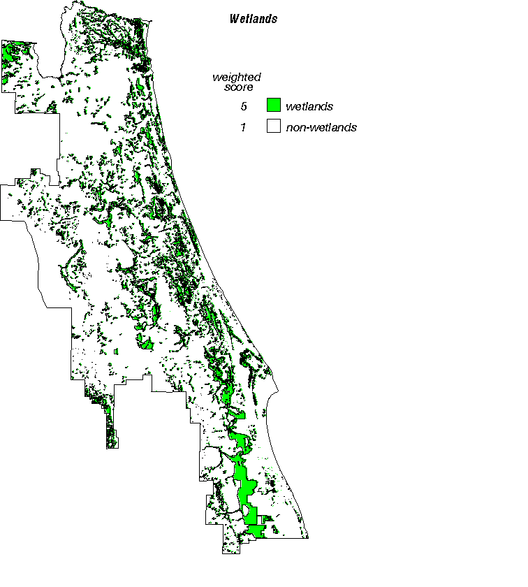
The wetland areas were of particular concern to this project because of the potential for vegetative impacts caused by increased withdrawals from the Floridan aquifer. Vegetative impacts can result from withdrawals in the Floridan aquifer. Withdrawals from the Floridan aquifer can induce drawdowns in the water level of the surficial aquifer which have the subsequent potential of affecting vegetation.
The wetland surface was created from the hydrography layer in the USGS Digital Line Graph (DLG) coverage. The layers designated as wetlands were reselected from the coverage and placed in a separate coverage. The layers reselected were hydrography, intermittent water bodies, deep water wetlands, marsh or wetlands, and mangroves. The polygon coverage of wetlands was processed through the GRID module to create a grid representing wetlands.
The projected population surface was selected to indirectly identify areas where future water withdrawals are expected to be large. This was the only surface that was able to incorporate some future or anticipated changes into the study.
The projected 2010 population density surface was created using a coverage of 1990 census tract population data. The 1990 population data were projected to 2010 by multiplying the census tracts within each county by a percentage representing the projected population change between 1990 and 2010 on a county level. After calculating the projected 2010 population figures, the population value for each census tract was divided by the area of the census tract to obtain the projected 2010 population density in persons per square mile. Dividing the 2010 population figures by the area of each census tract normalizes the data by accounting for varying population figures over varying census tract sizes.
The data in each grid were evaluated based upon the hydrogeology and a histogram distribution of the data. The data values for the items in each grid were weighted from 1 to 5 using a separate lookup table for each grid. A value of 1 indicated a factor having the least significance in causing or contributing to one of the three areas of evaluation, and a value of 5 indicated a factor having the greatest significance in causing or contributing to one of the three areas of evaluation. The items for each surface were weighted as shown in each figure.
A histogram distribution of the data was created for each grid. In some cases the distribution of the values led to the assigned weights, as was the case with the potentiometric surface grids. For other surfaces, weights were determined based upon knowledge of hydrology and geology and the relative influence of the factor or surface on (1) vegetative impacts, (2) salt water intrusion, and/or (3) an increase in water supply demand.
The vertical head difference between the surficial and Floridan aquifers grid was difficult to categorize into weights because at one extreme vegetative impacts occur and at the other extreme saltwater impacts occur. It was assumed that saltwater intrusion impacts could be more accurately accounted for, therefore, areas with low values having the potential for saltwater intrusion were weighted the highest. Specifically, in the wetlands surface, it was assumed that there would be little or no affect in locations where there were no wetlands; consequently, wetlands were weighted the highest.
The grids were also weighted against each other, by multiplying each grid by a factor ranging from 1 to 5. The grid affecting the overall weight the most received a weight of 5. The grid receiving a weight of 1 affected the overall score the least. The weights given to each grid are listed in Table 1.
Table 1. Grid weights
SURFACE......................................WEIGHT
long-term change in the.........................1
potentiometric surface of the
Floridan aquifer
short-term change in the.......................3
potentiometric surface of the
Floridan aquifer
confining unit thickness above the...........3
Floridan aquifer
vertical head difference between the........ 3
surficial and Floridan aquifers
percentage of potable water in the...........1
Floridan aquifer
horizontal distance to areas of no...........1
potable water in the Floridan aquifer
wetlands.....................................3
projected 2010 population density............5
The weighted grids were overlaid and weighted against each other before being added together to create a cumulative final score grid. The horizontal distance to no potable water grid and the percentage of fresh water grid were weighted using a value of 1 because they are conceptually and physically similar to each other. This weighting procedure causes the general distribution of the data to automatically appear twice in the overall scores. The long-term change in the potentiometric surface grid was weighted using a value of 1, and the short-term change in the potentiometric surface grid was weighted using a value of 3 because the current and near-future changes were more important to this study. The confining unit thickness above the Floridan aquifer grid was weighted with a value of 3 because it is an important factor affecting vegetative impacts. The vertical head difference between the surficial and Floridan aquifers grid was also weighted with a value of 3 because it affects both vegetative impacts and saltwater upconing. The wetlands grid was weighted with a value of 3 because of the high sensitivity of wetlands to changes in the water table and a general emphasis in Florida to preserve and/or enhance wetland functionality. The projected population density grid was weighted the highest, with a value of 5, because this is the only surface that accounts for projected future changes.
The possible range of scores on the final grid was from 20 to 100, where 20 indicated the least potential for impacts and 100 indicated the greatest potential for impacts. The distribution fell in to a classic bell-shaped histogram. The low, medium, and high potential categories were selected based upon the distribution. The public water supply service areas and regional ground water models were overlaid on top of the grid.
The low potential category was selected to have scores less than 40, the medium potential category, where the bell of the histogram occurred, was selected to be between the scores of 40 and 60, and the high potential category was selected to have scores greater than 60.
Several distinct areas show a high potential for these water resource problems. The Atlantic coastal areas show high scores, as do the Gainesville and Ocala areas. These areas appear with high scores due to several compounding factors. Along the coast these factors include the presence of poor quality water, the distance to poor quality water, changes in the elevation of the potentiometric surface of the Floridan aquifer, and large population projections. High inland scores occurring at Gainesville and Ocala are due to large population increases and changes in the elevation of the potentiometric surface of the Floridan aquifer, as well as to a thin confining unit in the Ocala area. Other areas showing a high potential are located north and northeast of Orlando. This area shows high scores due the occurrence of poor quality water, wetlands, negative vertical head difference, and significant change in the potentiometric surface of the Floridan aquifer.
The locations of the water supply service areas further defined those areas that need special attention, although it should be noted that some wellfields do occur outside of the water supply service areas. The cumulative effect of all the wellfields in an area can cause a general decline in the elevation of the potentiometric surface outside the water supply service areas.
The locations of the regional ground water flow models were overlaid on the final scored surface and the distribution of the regional ground water flow models shows that virtually all of the areas that have high scores fall within the flow model boundaries. It may be necessary to develop more site-specific subregional ground water flow or transport models to fully understand the effects associated with future water supply development. Several cities that fall outside any of the regional ground water flow models, including Ocala and Vero Beach, have been evaluated with local-scale analytical models.
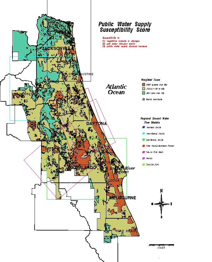
Those areas identified as having a high potential for vegetative impacts, saltwater intrusion and/or an increase in public water supply demand are apparent using this GIS methodology to overlay related grids. The results support the locations of the regional numerical ground water flow models and the local analytical ground water models. High potential for impacts is evident in the coastal areas where the combined effects of salt water, declines in the potentiometric surface of the Floridan aquifer, and high population density are the greatest. Several coastal cities, including Daytona Beach, have already found it necessary to move wellfields further inland due to saltwater encroachment. Areas of large potential impacts are in the Upper St. Johns River Basin and the major municipalities. An extensive area north and east of Orlando is currently identified as a water use caution area.
The methodology used in this study provides a tool which could be used to identify areas in need of water resource assessment and as an approach to evaluate the need for and location of new numerical and analytical ground water flow models.
Boniol, D., M. Williams, and D. Munch. 1993. Mapping recharge to the Floridan aquifer using a geographic information system. Technical Publication SJ93-5. Palatka, Fla.: St. Johns River Water Management District.
Causey, L.V., and G.W. Leve. 1977. Thickness of the potable-water zone in the Floridan aquifer. Map Series No. 74. Tallahassee, Fla.: U.S. Geological Survey,
[Esri]. Environmental Systems Research Institute. 1992.. ArcInfo Release 6.1.1, Redlands, Calif.
Johnston, R.H., R.E. Krause, F.W. Meyer, P.D. Ryder, C.H. Tibbals, and J.D. Hunn. 1980. Estimated potentiometric surface for the Tertiary limestone aquifer system, south-eastern United States prior to development. Open File Report 80-406. Atlanta, Ga.: U.S. Geological Survey.
Miller, J.A. 1986. Hydrogeologic framework of the Floridan aquifer system in Florida and parts of Georgia, Alabama and South Carolina. Professional Paper 1403-B. Tallahassee, Fla.: U.S. Geological Survey.