David Weinstein, Kass Green, Jeff Campbell, and Mark Finney
ABSTRACT


Research scientists and forest resource managers have long sought the
ability to model wildfire behavior.  Considerable effort has been directed
toward understanding the science of fire behavior and developing computer-
based modeling techniques for predicting fire growth.  Recent advances in
the field of fire science, along with the availability of high resolution
remote-sensed satellite imagery, powerful image processing software,
Geographic Information Systems (GISs), and affordable computer
hardware has enabled the development of sophisticated, yet easy to operate
fire simulation applications.

A fire simulation application, FIRE! has been developed which integrates
state of the art fire behavior modeling into the ArcInfo GIS environment.
The model's user interface has been designed so that advanced computer
and GIS skills are not required by for model execution.  The model puts the
power of comprehensive fire behavior prediction into the hands of qualified
on the ground resource managers where it can be most effectively applied.


INTRODUCTION


Fire plays a very significant role in the management of pine forests of the
Southeastern United States.  Both wildfires and controlled prescribed
burning significantly affect forest management activities from timber harvest
scheduling to reforestation and thinning operations.  Wildfires destroy
thousands of acres of prime forest land every year while controlled burning
helps to maintain a manageable fuel loading for forests susceptible to
destructive wildfires.  With the added complexity of managing productive
forests which also support active military operations and training,
monitoring and controlling both wild and prescribed fires is a particularly
challenging charge for the Division of Forestry at the Camp Lejeune Marine
Corps Base in eastern North Carolina.

Throughout the country as well, personnel, equipment, and financial
resources are tremendously strained  in the struggle to contain and
extinguish wildfires.  Thousands of firefighters and support staff are
engaged and millions of dollars are spent annually to preserve and protect
human lives and personal property as well as valuable timber and recreation
resources.  Twelve hour work days for weeks at a time in hazardous
conditions are not uncommon for wildfire fighting personnel during heavy
burning seasons such as those encountered during the past several years.

The continued emphasis on safety and resource protection by the numerous
state and local agencies charged with combating wildfire has increased the
need for more accurate and dependable tools for wildfire management.  For
several years, forest fire management personnel have utilized fire behavior
models such as BEHAVE (Andrews, 1986) to aid in predicting fire
behavior and subsequently mapping probable scenarios of fire spread
during a given time period.  BEHAVE is a non-spatial fire behavior
prediction tool.  Utilizing inputs of fire fuel type, topography data, weather
data, and initial fuel moisture data, BEHAVE calculates fire behavior and
fire characteristics for a given area.  While BEHAVE is very useful for
predicting fire characteristics for a given land area, the output is inherently
non-spatial.  In other words, the spread rates, flamelengths, fireline
intensities, and heat calculations generated by BEHAVE are applicable only
so long as the specified fuel type, topographic, and weather related
parameters do not vary.  As the topography or fuel model changes or as the
weather patterns shift, BEHAVE results must be recalculated in order to
provide an adequate approximation of fire behavior for the new input data
regime.  Considering the complexity of fuels, topography, and weather over
a given landscape during a period of time, efficiently and accurately
predicting fire behavior characteristics for a wildfire over time utilizing such
techniques is inefficient and often impractical.

However, through the incorporation of GIS technology, developing detailed
fire behavior predictions for numerous scenarios becomes not only possible
but incredibly efficient and effective.  The forest fire behavior model
developed for this project incorporates spatial fuels and topographic data,
temporal weather and wind settings and initial fuel moistures into the
prediction of forest fire behavior across both time and space.  The model
puts the power of sound, accurate, and efficient fire behavior modeling
technology into the hands of forest fire management personnel charged
with coordinating the containment and extinguishing of wildfires.  The
model can become one of the most effective tools for managing personnel,
financial, and equipment resources for battling one of the most destructive
and dangerous forces of nature.

PRODUCTS REQUIRED

The primary data source for the forest fire fuel model classification was
Landsat Thematic Mapper imagery, geocoded and terrain corrected to UTM
coordinates.  Landsat TM sub-scene from Path 14, Row 36, acquired
August 8, 1993, was utilized for this project.  The date of imagery was
chosen due to its combination of minimal cloud cover, optimum sun angle,
and optimum vegetation vigor and reflectance characteristics.  In addition,
1:15,840 scale color infra-red aerial photography for the study area was
utilized extensively.  The acquisition date of the photography was March 6,
1993.  Although collected during different seasons, the aerial photography
and satellite imagery were collected within five months of one another, thus
minimizing the amount of landcover change occurring between the two
dates of data collection.

Image classification was enhanced through the use of ancillary GIS data
layers.  Ancillary data utilized for the forest fire fuel model classification
included various ArcInfo GIS coverages representing past and present
land-use and land-cover characteristics.  The ancillary GIS coverages were
used to help ensure quality control during iterative and final fuel model
classifications.  The fuel classification was further refined through the
development and application of GIS models which examine the relationship
between overstory vegetation types, soil types, recent forest management
activities, forest fire fuels.  In addition to the fuels layer, canopy density,
slope, elevation, and aspect layers are direct inputs to the fire behavior
model.  Within the Camp Lejeune Marine Corps Base, however, the effect
of topography is minimal.  A total elevation change of approximately 35 feet
is present on the base.

Extensive use was made of field collected data, which was critical to both
fuel classification and calibration of the fire behavior model.  Ground data
for fuels, overstory and understory vegetation cover, and tree crown cover
was used to establish field training sites for image classification.  The
training sites were used to calibrate the computer classification of the image
to the actual fuel characteristics observed on the ground.  Data were
collected on field data forms which include delineations of fuel type on
aerial photography and draft classification maps.

Field data from past prescribed burns and wild fires collected by Camp
Lejeune Forestry Division personnel were extensively used in the fire
behavior model calibration process.  Base forestry division personnel
consistently collect detailed data regarding fire behavior (spread rates,
flamelengths, burn perimeter, etc.) for fires burning on the base.  Global
Positioning System (GPS) units are used to map fire perimeters.  The fire
behavior model was calibrated using this detailed data from past fires to
ensure the most accurate and reliable fire behavior predictions under local
conditions.  The incorporation of this past fire behavior data during the fire
behavior model calibration was among the most important tasks of the entire
project.  Calibration involves comparing predicted spread with observed fire
patterns for each fuel type.  The results yield an adjustment factor for each
fuel type that makes model predictions more accurate for the particular fuel
types and burning conditions.

METHODS

Fuels Layer
A combined supervised/unsupervised approach was used to classify the
Thematic Mapper imagery (Congalton et al., 1992).  All classification work
was performed using ERDAS (Atlanta, Georgia) image processing
software.  The imagery was classified into the thirteen models described by
Anderson (1982) and two non-fuels classes.  Anderson produced a
similarity chart for cross referencing the 13 fuel models he developed to the
20 fuel models used in the National Fire Danger Rating System.  The
classifications used for this project are listed below:

Fuel Model/Class	Model Description/Typical Complex

Grass and Grass-Dominated Models
	1	Short Grass (1ft)
	2	Timber (grass and understory)
	3	Tall Grass (2.5+ ft)

Chaparral and Shrub Fields
	4	High Pocosin/Chaparral (6+ ft)
	5	Brush (2 ft)
	6	Dormant Brush, Hardwood Slash
	7	Southern Rough/Low Pocosin (2-6 ft)

Timber Litter
	8	Closed Timber Litter
	9	Hardwood Litter
	10	Heavy Timber Litter and Understory

Slash
	11	Light Logging Slash
	12	Medium Logging Slash
	13	Heavy Logging Slash

Non-Fuel
	14	Water
	15	Bare/Non-Flammable

Each fuel model listed above is represents specific measure of fuel loading:
surface area to volume ratio of each size group, fuel depth, fuel particle
density, heat content of fuel, and moisture of extinction values.  This
description provides the necessary information for each fuel model to allow
for the automated modeling and calculation of fire spread rates and other fire
behavior characteristics provided in the GIS fire behavior model described
below.  The final raster classification of the forest fire fuel models was
converted from ERDAS format to ARC GRID format for incorporation into
the development and implementation of the fire behavior model.

Tree Crown Closure
A raster forest crown cover layer was also developed through classification
of the Landsat TM imagery.  Initially, "Water", "Bare/Non-Flammable",
and other non-forest fuel classes previously identified in the mapping of the
forest fire fuels were masked from the imagery.  These areas were assigned
a crown cover class of 0%.  For the remaining areas, a series of
unsupervised classifications was completed and labeled with one of the
following crown cover classes:

		  1 -	20% 	Tree Crown Cover
		21 - 	50% 	Tree Crown Cover
		51 - 	80% 	Tree Crown Cover
		81 - 	100% 	Tree Crown Cover

The resulting raster tree crown cover classification was also converted from
ERDAS format to ARC GRID for incorporation into the development and
 implementation of the fire behavior model.  The tree crown cover data layer
influences the effect of wind direction and incoming solar radiation in the
fire behavior model.

Upon completion of the raster fire fuels classification, polygon creation
algorithms developed by Pacific Meridian were utilized to convert the raster
GIS coverage into an ArcInfo polygon coverage.  In the coverage, each
polygon was assigned a label depicting its forest fuel model class.  The
polygon coverage was produced to provide base forest managers with a
vector coverage of fuel type which they can utilize alone or in conjunction
with other vector and raster data layers for future landscape analysis
projects.  The polygon coverage of forest fire fuel type was not directly
utilized in the fire behavior model development or implementation.

Model Development

Following the fire fuels classification, Pacific Meridian developed a new fire
simulation application, known as FIRE!, which brings fire modeling
capabilities to the ArcInfo GIS environment.  FIRE! is an ArcTools-based
application that allows a user to interactively specify all the required spatial
and non-spatial parameters and specify the time, duration, and locations of a
multiple ignition fire simulation.  Vector representations of fire perimeters
are graphically displayed as the simulated fire advances.  Potential flat
terrain spotting is computed and displayed for each perimeter.  At the
conclusion of the simulated burn, FIRE! also displays raster representations
of time of arrival, heat, fireline intensity, rate of spread, and flame length
for the burned area.  Plots of the simulation results may be generated using
built-in plotting templates or customized by the user with the full suite of
plotting tools available in ArcInfo.  All of the output data is preserved as
ArcInfo coverages and grids, which may be further analyzed by the user
with the full range of capabilities of the ArcInfo GIS environment.

The engine of the FIRE! application, responsible for all the complex
computations necessary for simulating fire behavior is FARSITE (Fire Area
Simulator) (Finney, 1993), a C++ program developed by Systems for
Environmental Management with support from the National Interagency
Fire Center (National Park Service) in cooperation with the Fire Behavior
Research Work Unit of the USDA Forest Service Inter mountain Fire
Science Laboratory.  FARSITE  interacts seamlessly within the ArcInfo
environment as a component of FIRE! enhancing the spatial display and
query capabilities of the GIS for fire modeling and analysis.  Figure 1
outlines a flow diagram for FIRE!.
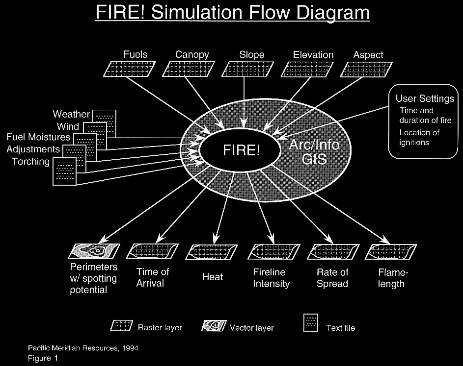
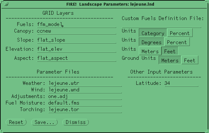
FIRE! allows a user to model fire behavior by defining a fire "scenario".
The scenario is comprised of three sets of input parameters: landscape files,
run parameters, and ignition locations.  A Geographical User Interface
(GUI) has been designed to allow the user to easily specify and edit the data
and parameters necessary to execute each simulation scenario set.  The first
set establishes the spatial and temporal data to be utilized by the model.  The
user specifies the appropriate fire fuels, canopy cover, slope, elevation, and
aspect layers required for the simulation.  In addition, non-spatial data sets
including weather, wind, initial fuel moistures, and fuel model adjustment
factors can be created, specified, and edited.
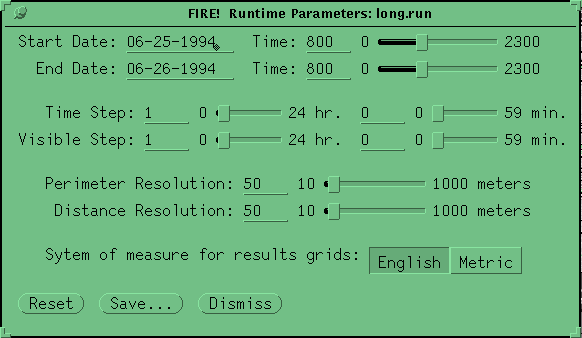
Run parameters include simulation start and end times along with the spatial
and temporal resolution of fire growth calculations performed during the
simulation.  For instance, a spatial resolution of greater than the raster
resolution may be specified for scenarios covering very large areas in which
only a gross estimation of fire behavior over a long time period is desired.
Specifying a greater spatial resolution reduces the computational
requirements of the model resulting in a faster simulation.  However,
scenarios requiring detailed information regarding fire behavior throughout
a simulation area should utilize a spatial resolution at least as small as the
input data sets provide.
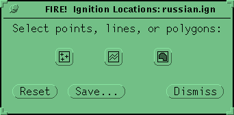
Finally, a data set identifying the location and configuration of a fire ignition

must be specified.  Fire ignitions may be established as points, lines, and/or
polygons and are entered interactively by clicking on the screen at the
desired ignition locations.
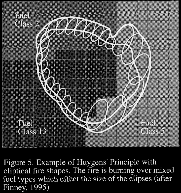
After defining the burn scenario, the model simulation can be executed.  As
the model performs the necessary fire behavior calculations, vectors are
displayed indicating the fire's perimeter at user-specified time intervals.  The
vectors may be displayed over the fuels raster data layer or the original
Landsat TM imagery.  At the completion of the simulation, raster data layers
are produced providing the flamelength, fireline intensity, time of arrival,
heat per unit area, and rate of spread of the fire for every pixel within the
burned perimeter.

FIRE! has been designed and developed to overcome many of the
shortcomings encountered with past fire behavior models.  Fire modeling in
the past suffered from two important limitations: the non-spatial qualities of
early methods based solely on BEHAVE, and the limitations of raster-based
models that followed.  FIRE!   employs the most recent developments in
wave-based fire modeling.  Wave-based models have been shown to yield
the most accurate modeling results available to date.

Early modeling efforts relied on BEHAVE, a non-spatial  model for
estimating fire characteristics, such as flame length, rate of spread, etc., for
a homogeneous surface.  Fire managers had to perform three labor intensive
tasks manually: delineating regions of homogeneous fuel characteristics,
computing BEHAVE statistics for each of these regions, and propagating
the fire front based on expert knowledge of fire behavior under local terrain
and wind conditions.  After each iteration of manual propagation of the fire,
the steps would then have to be repeated.  Modern spatial techniques still
use BEHAVE algorithms for computing fire characteristics while providing
automated methods for propagating the fire across a heterogeneous
landscape.

Raster-based spatial models rely on cellular propagation methods.  Cellular
models use the constant spatial arrangement of a cell or raster landscape to
solve for time of ignition (Finney, 1995).  The fire is propagated through
the raster in checkerboard steps, with cells igniting based on the
characteristics of other cells in their neighborhood.  Studies have shown this
technique to yield distorted representations of fire shapes owing to the
necessity of growing the fire from each burning cell in discrete steps in a
fixed number of cardinal directions available to the grid.

Vector or wave type models have been shown to closely simulate fire
growth with varying winds (Anderson et al.,1982; French, 1992).  Wave
models recognize the inherent wave-like behavior of wildfire; that is, that
the front propagates as a wave, shifting and moving continuously in time
and space.  Wave models solve for the position of the fire front at specified
times (Finney, 1995).  FARSITE uses a technique for wave propagation,
known as Huygen's principle (Anderson, et al., 1982), to expand surface
fire fronts in two dimensions (Richards, 1990) (Figure 5).  While rasters
are still used to represent the underlying landscape, and to record fire
characteristics during the simulation, the fire perimeters are processed and
stored as continuous vectors.
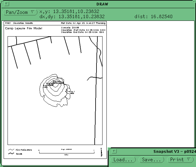
The Graphical User Interface (GUI) developed for the execution of the GIS-
based model allows natural resource managers not intimately familiar with
computers or GIS to effectively utilized the fire behavior model.  By
developing and incorporating a user friendly user interface for growth
execution, this model puts the power of fully utilizing the functionality of a
fire behavior model into the hands of a much wider range of resource
managers and technicians.  With minimal computer training and experience,
nearly anyone can identify and edit the necessary input data, develop a burn
scenario, execute the model, analyze the results, and produce hard copy
results output without ever being required to specify command line
instruction for direct computer interfacing.

Outputs

After defining the burn scenario, the model simulation can be executed.  As
the model performs the necessary fire behavior calculations, vectors are
displayed indicating the fire's perimeter at a user-specified time interval.
The vectors may be displayed over the fuels raster data layer or the original
Landsat TM imagery.  At the completion of the simulation, raster data layers
are produced providing the flamelength, fireline intensity, time of arrival,
heat per unit area, and rate of spread of the fire for every pixel within the
burned perimeter.  Figures 6 and 7 present example output files from a
FIRE!  simulation.

DISCUSSION

While the results of FIRE!  are, of course, only as good as the information
and assumptions entered into each scenario.  FIRE! is the first model that
integrates advanced wave-based fire simulation methods with a widely
utilized GIS platform in an easy to use, fully graphical environment.  Some
potential enhancements to the model include:  improved handling of torching
and spotting, with predictive techniques for simulating spot fires; real-time
updates of developing weather and wind patterns recorded in the field
during an actual burn; and interactive simulation of containment efforts by
allowing the user to create firelines and backfires during a burn.

One possible future application of FIRE! is integrating change detection
analysis using digital satellite imagery with fire fuels mapping and forest fire
behavior modeling.  For instance, a fire fuel model classification can be
developed from Landsat TM imagery for vast forested areas simultaneously.
Then, using change detection analysis techniques, regions of bug killed
forests may be identified and mapped again using Landsat TM imagery.  By
comparing the original fuels classification with the mapped areas of change
due to bug kill, updating of the fuels classification may be accomplished.
With the pre- and post-bug kill data sets, fire behavior analysis can be
completed using FIRE! for both fuel type scenarios.  This type of analysis
may be extremely beneficial for evaluating the potential effects of forest
management activities related to forest pest management to potential forest
fire behavior.  Such applications of FIRE! will allow the economic costs
and benefits of resource management decisions to be considered along with
ignition risk, and fire effects allowing for an informed, pro-active fire
management strategy.

REFERENCES

Anderson, D.G., E.A. Catchpole, N.J. DeMestre, and T. Parkes.  1982.
Modeling the Spread of Grass Fires.  J. Austral. Math Soc. (Ser.B) 23:451-
466.

Anderson, H.E.  1982.  Aids to Determining Fuel Models for Estimating
Fire Behavior.  USDA Forest Service General Technical Report INT-122.

Andrews, Patricia L.  1986.  BEHAVE:  Fire Behavior Prediction and Fuel
Modeling System-Burn Subsystem, Part 1.  USDA Forest Service General
Technical Report INT-194.

Congalton, R.G., Green, K., and Teply, J.  1993.  "Mapping Old Growth
Forests on National Forest and Park Lands in the Pacific Northwest from
Remotely Sensed Data".  Photogrammetric Engineering and Remote
Sensing, Vol. 59, No. 4, April 1993, pp. 529-535.

Finney, M.A.  1993.  Modeling the Spread and Behavior of Prescribed
Natural Fires.  In proceedings of the 12th Conference on Fire and Forest
Meteorology.  October 26-28, 1993, Jekyll Island, Georgia.

Finney, M.A.  1995.  FARSITE. Fire Area Simulator.  User's Guide and
Technical Documentation. Version 1.0.  Systems for Environmental
Management.

French, I.A..  1992.  Visualization Techniques for the Computer Simulation
of Brushfires in Two dimensions.  M.S. Thesis, University of New South
Wales, Australian Defence Force Academy, 140 pgs.

Richards, G.D.  1990.  An Elliptical Growth Model of Forest Fire Fronts
and its Numerical Solution.  International Journal of Numerical Meth.
Engineering.  30:1163-1179.
Jeff Campbell
Pacific Meridian Resources
421 S.W. 6th Avenue, Suite 850
Portland, OR 97204
Tel: (503) 228-8708 Fax: (503) 228-8751
E-mail: pmrp@teleport.com
Mark Finney
Systems for Environmental Management
PO Box 8868
Missoula, MT 59807
Tel: (406) 329-4837 Fax: (406) 329-4877