INTRODUCTION
Concerns about the impacts of farming on water quality prompted the establishment of the President’s Initiative on Enhancing Water Quality in 1989. Five study sites were selected by the United States Department of Agriculture (USDA) to address the water quality concerns. These five study sites are known as Management Systems Evaluation Areas (MSEAs). A major objective of the MSEA project is to evaluate the impact of alternative farming strategies on surface and ground water quality and to promote best management practices that enhance overall water quality.
Goodwater Creek watershed, the site of Missouri MSEA, is an agricultural basin and has a significant potential for soil erosion and surface and ground water contamination. Pesticides, particularly atrazine, and nitrate from fertilizers are the main potential water pollutants in the area. Water samples collected from stream monitoring stations and wells revealed that Atrazine concentrations in stream flow from the Goodwater Creek watershed have ranged from less than 1 to over 100 ppb (parts per billion), and nitrate - N concentration in ground water ranged from 0 to over 20 ppm (parts per million) (Blanchard et al., 1993). The maximum contaminant level (MCL) of atrazine set by the US Environmental Protection Agency (EPA) is 3 ppb for drinking water and the MCL of nitrate for drinking water is 10 ppm. Although Goodwater Creek watershed is not a source of drinking water, it feeds indirectly into the Mark Twain Reservoir, which is drinking water source for communities in northeastern Missouri.
Over the past years, a series of studies have been undertaken by soil scientists, hydrologists and agricultural economists to assess the effect of farming practices on water quality in the Goodwater Creek watershed at the plot and farm field scale. Water quality samples have been collected and analyzed to represent the influence of current farming systems on surface and ground water quality (Blanchard et al., 1993). Alternative farming systems involving different combinations of crop rotation, tillage methods and agricultural chemicals have been evaluated on replicated research plots in terms of economic and environmental effects and tradeoffs (Ma and Prato, 1993; Prato et al., 1993).
The purpose of this study is to develop methods and data for evaluating environmental consequences of alternative land management practices at the watershed scale. In particular, the Soil and Water Assessment Tool (SWAT) model is coupled with a geographic information system (GIS) to evaluate surface and ground water quality in the Goodwater Creek Watershed with respect to sediment, nutrients and pesticide loads. SWAT requires numerous input parameters, thereby requiring a tremendous amount of time and expertise in the modeling process. Using GIS, the parameter data can be generated and updated effectively.
Specific objectives of the study include: 1) to utilize ArcInfo GIS to compile, manage, analyze and display SWAT input and output; 2) to evaluate the current water quality status in Goodwater Creek watershed and to identify the areas that exceed water quality MCLs; 3) to determine water quality results of alternative management strategies at the watershed scale; and 4) to compare the water quality results of current and alternative farming systems and identify the best management practices (BMPs) for the watershed.
STUDY AREA
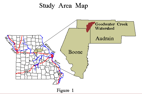
Goodwater Creek watershed is located in Audrain County and Boone County in north-central Missouri (Figure 1). The watershed covers 28 square miles (72.5 square kilometers). Agricultural lands occupy more than 78 percent of the watershed. The predominant crops in the watershed include corn, sorghum, wheat and soybeans. The dominant soil types are Mexico silt loam, Mexico silty clay loam and Putnam silt loam. The elevation ranges from 770 feet to 880 feet.
The MSEA alternative farming practices being evaluated in this study are: 1) corn-soybean rotation, high agrichemical input, minimum till; 2) sorghum-soybean rotation, medium agrichemical input, minimum till; 3) corn-soybean-wheat rotation, low agrichemical input, minimum till; 4) corn-soybean rotation, high agrichemical input, no till; and 5) sorghum-soybean rotation, high agrichemical input, minimum till.
THE SWAT MODEL
The Soil and Water Assessment Tool (SWAT) was developed by USDA-ARS to predict the effect of alternative agricultural management practices on water, sediment and chemical yields from river basins. The model is physically based and operates on a daily time step basis, and is capable of simulating long periods of output for computing the effects of management changes.
The SWAT model allows a watershed to be subdivided into subbasins and simulates at the watershed and subbasin levels. The SWAT input file structure consists of seven watershed and nine subbasin input files. Watershed input files contain general data bases and parameters about the watershed while subbasin input files contain input data that are specific to each subbasin.
The major output components of the SWAT model include surface hydrology, weather, sedimentation, nutrients, pesticides, groundwater and lateral flow, and crop yields. Sediment, nutrient and pesticide yields are considered the primary indicators of water quality. Calculation of sediment yield in SWAT is based on the Modified Universal Soil Loss Equation (MUSLE). Nutrient and pesticide yields are determined by soil type, management practices, tillage operations and the amount of fertilizer and pesticides applied, and are estimated in surface runoff, lateral flow and percolation.
METHODS
SWAT requires numerous parameters to simulate for a continuous- time and a large-scale basis. Thus the most critical component of the modeling process is collection of required data to drive the model. The data for most of these input parameters can be directly extracted from a few GIS layers. Other parameters need to be developed with manual assistance and linkage to GIS spatial databases.
Basic GIS Layers
Four basic GIS layers are required to extract spatial input for SWAT model. These layers are topography, hydrology, soils and land use. For each of these layers, the processing techniques used and the development of individual parameters are discussed below. During the course of this project, these procedures have been incorporated into a series of ARC Macro Language (AML) programs to accomplish the tasks of continual updating and rapid re-computation of the input parameters as alternative scenarios develop. The Center for Agricultural for Agricultural, Resources and Environmental Systems (CARES) created some of these layers in another MSEA related study.
1. Topography
An elevation layer is used to develop the necessary topographic inputs for the SWAT model. The layer was created by digitizing contour lines off USGS 7.5 minute quadrangle maps. The elevation coverage is used to generate a hydrologically correct digital elevation model (DEM) of 1-acre cell size with the TOPOGRID function. The TOPOGRID module is facilitated with a drainage enforcement routine which clears all spurious sinks not identified as known topographic depressions. The flow direction of each grid cell is derived from the DEM grid using the FLOWDIRECTION function and is used as input to the WATERSHED function to determine subbasin outlets and drainage contributing areas to the outlets. The process results in the identification of 58 natural subbasins in the watershed with an average area of 1.33 square kilometers (Figure 2).
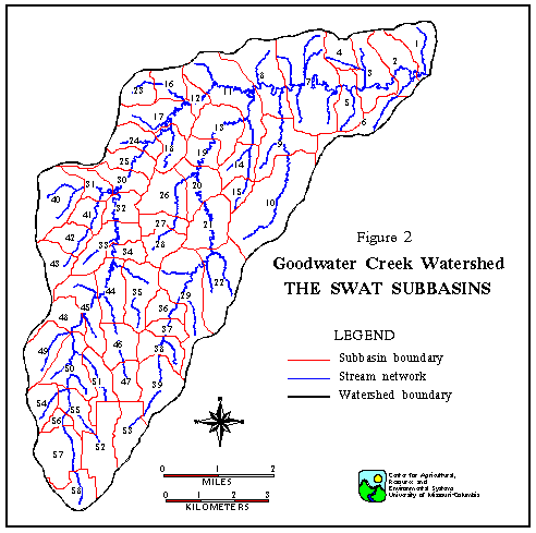
Conversion of the subbasin grid to a polygon coverage is accomplished by using GRIDPOLY, which converts the grid layer back into a coverage containing polygons with step-wise boundaries. The subbasin polygon boundaries are then smoothed to resemble natural drainage divides. Areal calculations for each subbasin are generated automatically when the polygons are created.
Computation of overland slope steepness for each subbasin involves calculating slope percent rise for each cell in the DEM grid via the SLOPE function and averaging the resulting values within each subbasin. The subbasin id is used as the common item for transferring slope data from the slope grid to a subbasin polygon coverage.
2. Hydrology
A hydrographic layer containing the watershed stream network is used to develop the channel input data. The stream network is digitized from USGS 7.5 quadrangle maps. For stream channels, the SWAT input data include channel length, channel slope, channel top width, channel depth, Manning’s n values, the hydraulic conductivity of the channel alluvium, and USLE K factor. The data parameters are required for the main channel and the longest channel in each subbasin. The main channel of a subbasin is the one that flows from subbasin inlet to the subbasin outlet while the longest channel is the stream segment between the subbasin outlet and the most distant point in the subbasin.
The main channels and the longest channels are selected out respectively to create two new arc coverages. Stream lines in each coverage are cut into segments with subbasin polygons and encoded with respective subbasin ids. The length of channel is calculated automatically for each subbasin when the channel segments are formed. The elevation of the two end-nodes of each stream segment is determined with elevation TIN (triangulated irregular network) model and TINSPOT function. The slope of channel is determined by dividing the channel length with the elevation difference between the “starting” and “ending” nodes.
Hydraulic conductivity and USLE K are supplied by county Soil Conservation Services (SCS) soil reports. These parameters are associated with soil types and are linked to the soil data base. The channel coverages are overlaid with the soils layer to determine the percentage length of each channel segment fall in each soil polygon. A weighted average approach is then used to compute hydraulic conductivity and USLE K factor for the main and longest channels in each subbasin.
A flow path database of the main channels is developed by determining the receiving subbasin for any given subbasin and is used to construct the routing configuration for the watershed. An AML program (FIG.AML) developed at CARES accomplishes the constructing process. The program defines a cursor pointing at the subbasin data base and links with the channel flow path data to route and add flow through the watershed. The routing algorithm of FIG.AML is based on a study by Arnold et al. (1993).
3. Soils
The source for soils information is the SCS soils maps at 1:24,000 scale. The soils layer is overlain on the subbasin layer to compute the dominant soil type for each subbasin. Within each subbasin, soils are assumed uniformly distributed. The resulting seven dominant soils include Mexico silt loam, Mexico silty clay loam, Putnam silt loam, Adco silt loam, Belknap silt loam, Leonard silty clay loam and Wilbur silt loam.
4. Land Use
Land use data are based on interpretation of 1990-1991 aerial photos and crop history data which describe actual crops planted in a specific farm field in a given year. Four years of crop record data from 1990 to 1993 were collected from local ASCS offices. However, about 15 percent of the fields lack any crop records. The prevailing land uses or crops in the watershed include corn, soybeans, sorghum, wheat, hay, pasture, forest, urban , water body and road.
The crop record data are converted into INFO tables and linked to the land use spatial layer to generate four annual crop history coverages. Average areal percentages of crops are computed on the basis of four years of crop data to represent current farming practices. These crop percentages are used to further subdivide subbasins into sub-subbasins without spatial positioning. In order to reduce the amount of computing time and yet maintain reasonably accurate land management information, two pre-processing steps are taken to adjust the crop percentages. First, the adjustments are made in the use of overall watershed crop percentage data for the subbasins with more than 50 percent of no data crop lands. Second, any land uses or crops occupying less than 7.0 percent of the subbasin are dropped and the percentage areas are allocated to the remaining categories on weighted basis. Thus the total percentage of land uses or crops in each subbasin maintains 100 percent. As a result, land use categories are narrowed down to include corn, soybeans, sorghum, wheat, hay, pasture, forest and urban. Each subbasin contains 2 to 5 categories. A total of 259 land use based subbasins are generated for the Goodwater Creek watershed.
Other Parameters
1. Management Input Data
Management input files of current and alternative farming strategies are compiled for land use categories including corn, sorghum, soybeans, wheat, hay, pasture, forest and urban. Each management file includes data for management operations such as planting, harvest, tillage operations, and pesticide and fertilizer application. Inputs include dates, operation type code and application amounts. These input parameters for the current farming practices are gathered through various sources. The main sources include 1994 Missouri Farm Facts (1994), Grain Crop Pesticide Use in Missouri (1992) and personal communications with MSEA project researchers and university extension scientists who have conducted field observations in the watershed for years. The management input data of alternative farming systems are mainly derived from the MSEA Management Plan (Kitchen, 1993).
By compiling detailed management files, the option of using actual nutrient application is chosen over the automate application option. Thus, management code input files (*.mco) contain no data.
2. Soils Data
Soils input files are developed for the six dominant soil types present in the watershed by using SWAT supported RUNSOIL program. Two SWAT soils data bases SOILCAL.DAT and SOILCMZ.DAT contain such information as bulk density, available water capacity, saturated conductivity, particle size, organic carbon and maximum rooting depth for thousands of soil types. The RUNSOIL program extracts data from the soils data bases and creates a soils input file for each soil type desired.
3. Soil Runoff Curve Number (CN)
Soil runoff curve number is the SCS antecedent moisture condition II curve number and is used to estimate runoff volume in model simulation. The SCS curve number varies from place to place based on hydrological soil group, hydrologic condition, management practice and landuse. Based on SCS soil reports for Audrain and Boone counties, the majority of the soils are classified as belonging to SCS hydrological soil group D in “good” hydrologic condition. Thus CN values are chosen from a SWAT data table based on the hydrologic soil group and crop type.
4. Weather and Rainfall Data
Required weather and rainfall data include monthly average, maximum and minimum temperatures, daily precipitation and rainfall frequency in the study area. The weather input file (*.wgn) is generated by running the model supported GETWEAT program given the approximate latitude and longitude coordinates of the Goodwater Creek watershed. The same weather and rainfall conditions are assumed for each subbasin since the Goodwater Creek watershed covers a relatively small area of 28 square miles.
All climate adjustment factors are set to zero percent based on the proximity of the Columbia, MO weather station used in GETWEAT to the Goodwater Creek watershed. No climate adjustment allows the use of actual simulated weather data with regard to rainfall, temperature, radiation and humidity.
5. Channel Dimension Parameters and C factor
Stream channel parameters not directly extracted from the hydrographic layer include channel’s roughness coefficient (Manning’s n values), channel width and depth. One approach would be to utilize GIS to estimate the channel dimension based on hydrologic, land use and soils properties (Srinivasan and Arnold, 1994). In this study, actual measurement data of channel width and depth are available through other research projects (Heidenreich, 1995). The channel dimension data contain 43 measurements and vary very little throughout the watershed. Therefore, an average value of the measurements is used for all channels.
USLE cover factor C for stream channel is uniformly set to 0.5 for this study. The C factor value is allowed between the range of 0 to 1, where C = 1 indicates no vegetation covering the stream channel; and C = 0 indicates the channel is completely protected so no degradation can occur. On observing stream vegetation covering condition in the field, it is considered that a medium stream C factor value 0.5 appropriately approximates the area.
6. Others
No pond input files (*.pnd), reservoir input files (*.res) and lake water quality input files (*.lwq) are generated for the study because no significant ponds, reservoir or lakes are present in the watershed. The only water bodies in the watershed are a few small agricultural ponds ranging from 0.05 acres to 13.3 acres.
The USLE erosion control practice factor P is associated with land slope and slope length. Based on actual slope data in the watershed and a P-factor table by Wischmeier and Smith (1978), two P values are used for the area, namely P = 0.60 for subbasins with 1 to 2 percent land slopes and P = 0.50 for others.
Model Application
The current farming practices and five MSEA alternative farming practices are being evaluated with the SWAT model. Each model run uses a 20 year simulation. Because land use management is the only target in this evaluation, all input files except management files remain unchanged for each model run.
EXPECTED RESULTS
The SWAT model is currently being refined to run alternative land management scenarios, and the simulation outputs are being interpreted and analyzed. SWAT generates voluminous simulation results for hundreds of components. Each component is reported in monthly and annual summaries for each subbasin and the overall watershed over the 20-year time span. Water quality results consist of sediment, nutrient and pesticide yields. Outputs involving nutrient and pesticide yields are far more numerous, including concentrations in surface runoff, leaching, transport by sediment, and so on.
The interpretation of water quality results is expected to include: 1) comparing average annual and monthly watershed values of each water quality component among the different land management practices, and 2) comparing and mapping average monthly and annual subbasin outputs of each water quality component for each farming system.
SUMMARY AND CONCLUSIONS
Agricultural practices generate potential pesticide and nitrate contamination for the surface and ground water in the Goodwater Creek watershed, Missouri. The SWAT model is used to assess the impact of current and alternative farming practices on water quality in the area. The modeling process involves acquiring input data, running the model and analyzing the results. ArcInfo is used to generate and update the input parameters in an automated manner.
A GIS data base containing topography, hydrology, soils, and land use and crop histories is created and used as basic sources of input parameters for the SWAT modeling. In this study the watershed is subdivided into 58 natural subbasins based on the topography and hydrology in the area, and further subdivided into 259 second level subbasins according to crop percentages in each subbasin. SWAT simulates sediment, pesticide and nutrient yields at the watershed and each subbasin outlet. The simulations are being performed on current and five alternative farming practices respectively. The outputs allow for geographical and temporal examination and comparison of water quality status within a single management practice and across different farming systems.
ArcInfo proves to be an efficient tool in deriving the information needed to run the SWAT model. Yet, the amount of time and expertise required are still very much dependent on the goals and scale set for a specific project. AMLs developed through the course of this project have allowed rapid updating of input files and large scale simulating of numerous subbasins to become feasible. These AML programs can be used in similar SWAT modeling studies and can be further integrated into a graphic menu interface. Undoubtedly, future water quality modeling studies will rely heavily on the use of ArcInfo and the development of AMLS and menu interfaces.
ACKNOWLEDGMENTS
The research is conducted through a grant from The Center for Agricultural and Rural Development (CARD), Iowa State University. The writers are grateful to CARD. The writers also wish to acknowledge Raghanvan Srinivasan, Jeff Arnold and Nancy Sammons, USDA-ARS at Temple, TX, who have been providing generous help on revising the SWAT model to meet the specific needs of this project.
REFERENCES
Arnold, Jeff G., R. Srinivasan and B.A. Engel. 1993. Flexible Watershed Configurations for Simulating Models. unpublished report.
Blanchard, Paul E., Newell R. Kitchen, William W. Donald and Lynn K. Heidenreich, 1993. Ground water transport of agricultural chemicals at the Missouri MSEA. Proceedings of 3rd Annual Water Quality Conference, Feb. 4-5, 1993, Missouri Agricultural Experiment Station, p93-99.
Heidenreich, Lynn K., 1995. Analysis of Alternative Atrazine Policy Impacts on Surface Water Quality Using SWAT. Master thesis in progress, University of Missouri at Columbia.
Integrated Pesticide Management Unit (IPM), 1993. Grain Crop Pesticide Use in Missouri, 1992. Pesticide Impact Assessment Program report, USDA ES 92-EPIX-1-0069, 6/1993.
Kitchen, Newell, 1993. The MSEA Management Plan. Unpublished Report.
Ma, Jian and Tony Prato, 1993. Integrated Economics and Environmental Evaluation of Missouri MSEA Farming Systems. Proceedings of 3rd Annual Water Quality Conference, Feb. 4-5, 1993, Missouri Agricultural Experiment Station, p84-87.
Missouri Agricultural Statistics Service, 1994. 1994 Missouri Farm Facts, A Complete Summary of Missouri’s Agricultural Production, August 1994.
Prato, Tony, Feng Xu and Jian Ma, 1993. Costs and returns of alternative systems in Missouri MSEA. Goodwater Creek Watershed Farming Systems Water Quality Project, Presentations given at the 1993 Field Day, August 19, p.11-11.
Srinivasan, R and J. G. Arnold, 1994. Integration of a basin- scale water quality model with GIS, Water Resources Bulletin, 30(3), p.453-462.
Wischmeier, W.H. and D.D. Smith, 1978. Predicting rainfall losses - A guide to conservation planning. USDA Agricultural Handbook No. 537. Washington DC, 58p.
Yan Zhou, Research Associate
Lynn Heidenreich, Research Associate
Tony Prato, Professor and Director
Christopher Fulcher, Associate Director and Research Associate
Steven Vance, Research Associate
Christopher Barnett, Research Associate
Center for Agricultural, Resource and Environmental Systems (CARES)
200 Mumford Hall
University of Missouri
Columbia, Missouri 65211
Telephone: (314) 882-1644
Fax: (314) 882=3958