Javier Gutierrez Puebla, Rafael E. Gonzalez Aguayo

This paper reports the design, implementation and results of a trans-european
scale transportation accesibility model. This study report only the results of
the railways portion of the model, which includes multiple categories of lines
within the transportation hierarchy.
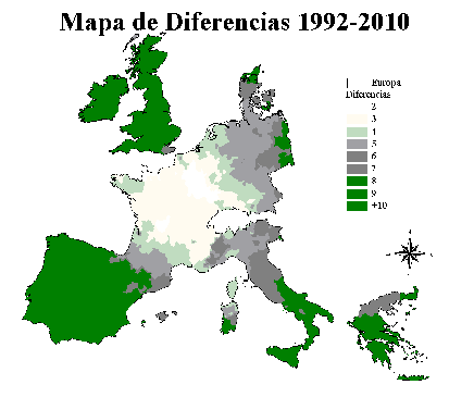
The rail network was digitized over the road network and the design considers not only the railways but also the possibility of taking another means of transport in order to access the train. Implementation of the model used indicators of 'absolute accesibility' similar to those reported in Gutierrez et al. (EGIS'93), except for important differences resulting from enhanced network analysis capabilities in the most recent version of the GIS software. Analysis includes construction of isoaccesibility contours zones showing net increase in accesibility and differences maps.
The antiquity of the conventional railways in relation to the continuous advance of the rest of the means of transport and the necessity of complementary means that imply annoying breaking of load zones, have forced to develope an increasing investigation effort to transform the train in a more competitive mean. At dawn of the Second World War the concept of the High Speed Train arises as a possible solution to this problem. The High Speed in Europe doesn't appear until September 1981, with the partial opening of the new Paris-Lyon railway -- though this wasn't the first one who began to be built. This railway was a big success attracting even some of the trips that until then had been made by plane or road, and generating a larger demand besides. In answer to this kind of iniciatives, some countries of the European Community continued the developement of High Speed railways paying attention to their different national needs, but following the same common objective:
"give the train a different offert from the actual one, more competitive, capable of winning a bigger share of the travel market, taking place as an alternative to the airplain and the road".
Seeing the interest of each of the countries of the European
Community and facing the possibility of each country designing the
railway as he pleases,and considering only his own necesities at the
margin of the european view, the European Community decided to stop this
tendency proposing the creation of an European High Speed Network, and
working out a guiding plan of it (Guiding Plan of the European High
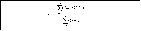
Speed Network). This plan extends till 2010 (see map 1) and includes the
following railways:
- 9.000 Km. of new railways, capable of carrying
- 250 Km/h or higher velocities.
- 15.000 Km. of improved lines, prepared for velocities of arround 200 Km/h.
- 1.200 Km. of connection (or framework) railways.

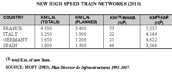
If the foresights of the previous table are fulfilled, Spain will have a total of 46 kilometers of new created railways for each million of inhabitants, more than twice the corresponding ones of Germany and Italy, being the second after France. If we consider the number of network kilometers in relation with the number of square quilometers of territory, then Spain will be in the fourth place in spite of having a lesser density of population. The High Speed train is thought of as an integrator element:
"The High Speed train, as it reduces the duration of the travel it also reduces the distances. This is the reason of it being a powerful instrument of arrangement of the territory. The European network will have an organizing effect on the communitary space and it will promote the regional developement and the relation between regions"Besides the high speed train is a better option for carrying out the environmental criteria and it has a lesser energy consumption. Nevertheless not all are advantages:
"The building of new infrastructures has an important environmental cost and implies a very high investment. On the other hand, the territorial effects of these infrastructures is very punctual because only the main cities have train stations which has the aditional danger of increasing the territorial umbalance already existent."
Other of the more bothersome problems is the possible incompatibility of the different High Speed networks. It's not completely clear if a direct connection among the sections of the different countries can be achieved, being this the final purpose of the Transeuropean network.
The accessibility indicators try to "give a measurement of the
separation of activities or human settlements that are connected among
them by a transport system". It is important to take into account that
all accessibility index must have some necessary elements: "the
proximity measurement or separation between two or more points; the
relation to a transport system that allows to cover the distance between
them; the "effort" (time, cost...) needed to cover it; and the relation
with some type of activity in which the user wants to take part".
Taking this definition as a reference point, it was decided to establish
an indicator to undertake this study. The indicator formulation is based
on calculating the average impedance of each node in relation to the
diferent economic activities centers through the network (using the
minimum cost path), taking as a weight factor the Gross Domestic Product
(GDP):
So the easiness to access an economic activity center
is a function of the resistence to move between the origin and
destination nodes. This resistence is expressed in impedance units, and
the accessibility value to reach each node is the average distance to
the center, taking as weight factor the importance of the destination
economic activity center. Therefore, the accessibility levels (derivated
from the indicator used) show the influence of the geographic siting of
the nodes and the infrastrutures influence. The measurement of the
impedance between origin and destination nodes is just the addition of
the arcs impedances covered to get from the first to the second node
using the minimum path. But besides, in the case of train it can happen
that the origin point of a travel is not a primary node (a node with a
train station connected to the network), which implies that to calculate
the impedance it is necessary to add an extra cost for the complementary
conexion to the road network. In conclusion, the easiness to access
depends on the following factors:
I= Ir + Imc + In
Where:
I is the real impedance.
Ir is the impedance by road from the origin node to the nearest primary node.
Imc is the impedance for changing of mode.
In is the network impedance between the origin and destination node.
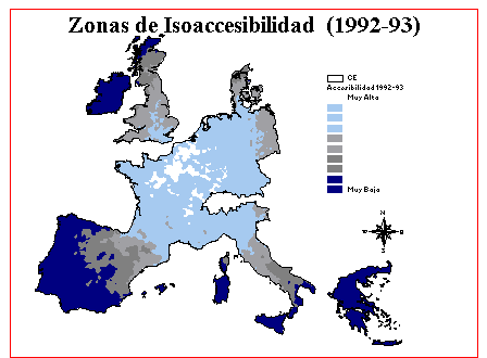
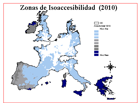
One of the goals of this study is to obtain an accessibility zones
map for the two planned horizons. The Geographic Information System
ArcInfo was used to achieve this end following the next proccess: For
the real impedance calculation (I) it is needed to know the distance
between every origin node and destination economic activity center
accross the network. To obtain it the INTERACTION ArcInfo command was
used. This command calculates the spatial interaction rate between two
nodes of a network, using the origin and destination nodes as
interaction centers. With this intention the network was provided with
arc and node topology (AAT and NAT) coding these according to what has
been previously said. For the calculation of interactions it was
necesary to design a centers table with the nodes for which it is needed
to measure the distances. As the process was applied to more than 4000
nodes and 94 economic activities centers, it was necessary to develop an
AML program with two loops changing the origin and destination nodes of
this table automatically until finishing the total number of trips;
resulting in a table with more than 368.000 registers, with all possible
connections and the interaction rate an time cost associated. The centers
file contained the following items:
As the object of this work is to show the process and not to comment the final results, these remarks are going to be very concise:
The following pages show the final accessibility maps created.
The aforementioned study has been cofinanced by the European Community FEDER funds of cohesion and subsidies channelled by the CYCIT.