Greg Bryant, GIS Analyst
Steve Schmitzer, GIS Analyst
Denver Water
1600 W. 12th Avenue
Denver, CO 80254
Telephone: (303) 628-6543
Fax: (303) 628-6852
Lawn Irrigation Return Flow Modeling Using GRID
Abstract
Denver Water desires to fully use its water supplies. This includes quantifying and reusing water used for lawn irrigation that is not fully consumed and returns to streams through shallow aquifers. Techniques for quantifying ground water returning to a stream as a result of lawn irrigation can be automated using ArcInfo GRID tools. This paper describes a method developed by Denver Water using GRID in combination with analytical equations described by Glover (1977) and Schroeder (1987) to quantify irrigation return flows. Glover return flow factors for the lower Cherry Creek basin in metropolitan Denver were calculated based on aquifer saturated thickness, specific yield, and hydraulic conductivity, in combination with distance to stream and width of the aquifer. Lawn irritation data and Glover return flow factors were then used to determine irrigation return flow patterns over an 18-year period.
Study Area and Background
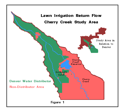
Denver Water's service area includes more than 15,000 acres in the Cherry Creek basin. The Cherry Creek basin study area extends from Cherry Creek's confluence with the South Platte River in Denver, to upstream of Cherry Creek Reservoir, which is southeast of Denver. It includes both Cherry Creek and a major tributary, Goldsmith Gulch. Figure 1 shows the study area and it's relationship to the city of Denver. This area represents about 8 percent of Denver's total treated water service area.
Denver currently serves more than 24,000 acre-feet of treated water to customers in the Cherry Creek basin each year. About 10,000 acre-feet of this amount is used outdoors from April through October (Peters 1994). About 10 percent of the water used outdoors is for non-irrigation uses or is lost as surface runoff and spray loss. The majority of water used outdoors is consumed through evapotranspiration by lawns, shrubs and trees. Another portion that percolates past the root zone and recharges the aquifer is referred to as "deep percolation" water. Over time, this deep percolation water discharges into Cherry Creek and Goldsmith Gulch.
In general, lawn irrigation that occurs near these streams in highly permeable material returns to the streams in a matter of days or even hours, while water applied farther from the streams in low permeability material can require many years to return. For this study, Denver Water analyzed irrigation water usage and irrigation water return patterns over a 17-year period from September 1976 through December 1993.
By quantifying the amount of reusable deep percolation water that reaches a stream, Denver Water can reuse the water in many ways. Denver can obtain water rights to store the water in a reservoir, divert the water, or exchange the water upstream.
Glover Return Flow Factors and Return Flow Computations
Quantifying the amount of irrigation water that returns to a stream network is a multi-step process. The general steps are as follows:
1) Calculate total amount of water applied for irrigation.
2) Determine potential consumptive use of water applied.
3) Determine how much of the total water applied becomes deep percolation water.
4) Perform Glover analysis to determine the timing and percentages of water return to streams.
5) Calculate return flows by applying Glover values to deep percolation amounts.
Steps 1-3 were estimated using techniques not discussed within this report. The focus of this report is to describe how ArcInfo's GRID tools were used to perform the Glover analysis and then how Glover values, in conjunction with historical deep percolation amounts, were used to determine the timing and amount of flows returning to streams.
Glover Analysis
The mathematical relationships between deep percolation and the resulting return flows to a stream have been derived by several investigators including Glover (1977). In essence, Glover "return flow factors" are expressed in terms of the percentage of deep percolation water from any month which returns to the stream during the month of application or in any subsequent month. Hence, if 100 units of water were applied to an area in January of 1985, and if the Glover return flow factor for month 1 for the irrigation area were 0.25, then 25% of the 100 units of water would return to the stream in January of 1985. If the return flow factor for month 2 were 0.20, then 20% of the 100 units of water returned to the stream in February of 1985, leaving 55% of the water in the ground as of the end of February 1985. It follows, then, that the sum of Glover return flow factors for all months can never exceed a value of 1, which would represent 100% of the water returning.
The work in this report was based on Glover equations which calculate stream depletions from a pumping well. These equations can conversely be used to describe return flows from a recharging well. For the purposes of this study, the study area was viewed as a grid of 100 meter by 100-meter cells, into which deep percolation water was "flowing" by virtue of a well in the center of the cell. The following discussion describes the derivation of the Glover equations. The equations use several variables, all of which are listed below:
q = the rate of stream depletion (or accretion)
Q = the pumping (or recharge) rate
K = hydraulic conductivity
D = saturated thickness
S = the specific yield of the aquifer or void ratio
t = time since pumping began
X = the perpendicular distance from well to stream
XN = the hypothetical distance from image well N to stream
Z = intermediate value, used to derive the "error function" value
v = cumulative volume of stream depletion (or accretion)
V = cumulative volume of deep percolation
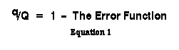
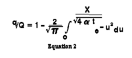
Equation 1 is the expression for the depletion rate (or return flow rate) for a stream from a pumping well. It uses "the error function" which is a mathematical relationship prevalent in many scientific and engineering applications. Equation 2 is the same as Equation 1, but shows the actual error function.
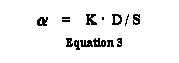
A crucial value in the derivation of the error function is the variable "alpha." In a sense, the alpha variable is the fundamental starting place in the derivation of Glover values. As displayed in Equation 3, alpha is the product of saturated thickness multiplied by hydraulic conductivity, divided by specific yield of the aquifer.
In addition to being described in Table 2, the exponential integral within the error function can be solved using the series displayed in Equation 4, which uses Equation 5.
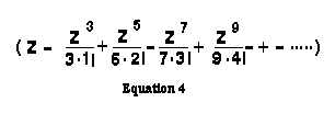
When solving Equation 4, series terms are summed until a term with an absolute value smaller that .00000001 is reached, assuring series accuracy to the 5th place to the right of the decimal.
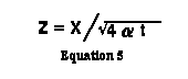
An alternate way to get at the error function is to solve Equation 5, deriving a value for Z. As the "error function" is a standard numerical relationship, the error function of Z can be found by using error function generator utilities on a calculator or within certain spreadsheets. Once the error function has been determined, the depletion rate (or return flow rate) for a stream can be found by solving for 1 - "the error function", as displayed in Equation 1 above.
Once q/Q has been determined, the ratio of volume of depletion (or accretion) of a stream to the volume pumped, the variable v/ can be calculated by Equation 6.
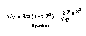
Image Wells
When dealing with ground water flow equations, there are numerous assumptions that must be made in order for the equations to be completely valid. One major assumption is that the aquifer is of infinite extent, uniform thickness, homogenous, and that the saturated thickness does not change with time. Other assumptions include: If an impermeable boundary exists, it is straight and parallel to the stream; the stream is straight, infinite in length, and fully penetrates the aquifer; the pumping (or recharge) rate is constant and the diameter of the well is negligible; the water table is flat, water is released instantaneously from storage, and the temperatures of the stream and the water in the aquifer are the same and both are constant. Because these assumptions deviate from the real world, their effects must be considered, especially in situations where the variable time becomes large. Departure from the idealized conditions may cause stream depletion to be either greater or lesser than that calculated.
Regarding the first assumption listed above, the technique of using imaginary wells or "image wells" is used to account for boundary conditions. As time increases, an aquifer is likely to be affected by a hydrogeologic boundary. A boundary can be either the edge of an aquifer or a source of recharge such as a stream or lake. Thus, boundaries are considered to be either recharge or barrier boundaries. Imaginary or image wells are used to adjust for situations where boundary conditions exist.
The recharge boundary condition caused by the presence of a stream can be simulated by placing a recharging image well directly on the opposite side of the stream and at the same distance as the pumping well. The rate of recharge is set to match the rate of the pumped well. Likewise, a barrier boundary can be simulated by placing a pumping image well on the opposite side of the boundary and at the same distance as the pumping well. Again, the rate of pumping of the image well is set to equal to the rate of the pumped well. This configuration of image wells is shown in Figure 2.
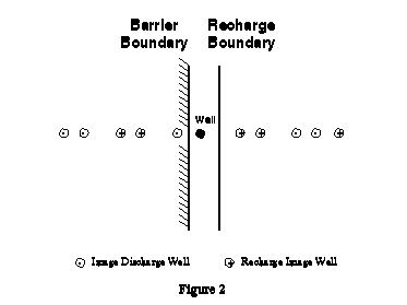
If image wells are used to account for a situation in which there is both a recharge and a barrier boundary, the image wells are added in pairs until the most distant pair contributes less than 0.00005 to the rate of depletion (q/Q). For this study it was determined that five pairs of image wells were necessary to insure that all wells, or grid cells, being modeled would meet the above criteria.
Summarizing Glover Return Flow Factors
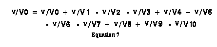
In essence, all of the Glover calculations outlined above are performed on the actual well and all hypothetical image wells for each month. The final v/V values for each individual well or image well, as calculated in Equation 6, are combined to estimate cumulative return amounts for the month using Equation 7 below.
These cumulative returns are used to derive the final return flow factors for any month. In month 1, the cumulative return is equal to the return flow factor. In all subsequent months the return flow factor is equal to the cumulative returns for the month being processed minus the cumulative returns for the previous month. In summary, all equations outlined in this discussion must be run for each month that return flow factors are calculated.
Input Data Sources
As stated earlier, to solve the Glover equations, one of the first values required is alpha. Alpha is based on hydraulic conductivity, saturated thickness and specific yield of the aquifer. These three hydrogeological datasets, along with distance to stream and width of aquifer, form the basis against which all subsequent Glover calculations are performed. Hence, a discussion of the base maps from which the hydrogeological datasets were derived is in order.
Hydraulic conductivity is a measure of the capacity of a porous medium to transmit water. Hydraulic conductivity characteristics were based on classifications reported by Schroba (1980), and utilized a relationship between soil classification and hydraulic conductivity reported by Powers (1981). Values for hydraulic conductivity ranged from less than 10 feet/day to more than 500 feet/day.
Saturated thickness was primarily based on data for depth to water (Hamilton and Owens 1972) and depth to bedrock (Hillier et al., 1983). Saturated thickness ranged from 5 feet to more than 60 feet. Specific yield, the ratio of the volume of water an aquifer will yield by gravity drainage to the volume of aquifer, was assumed to be 0.2 throughout the area.
Procedures
The above equations were built into GRID algebra statements using input grid data of the hydrogeological datasets and distance to stream and distance to aquifer edge datasets. With the "pumping well" iteration of Glover calculations, each cell in a grid of the study area was treated as an individual well, accounting for irrigation in the area represented by the grid cell. A grid of 100 meter cells was created to encompass the study area. The resulting grid was 225 cells by 225 cells, of which 14,626 cells were within the drainage and 6,442 of the cells were within Denver Water's service area. Earlier attempts at the application were done with 25-meter and 50-meter cells, but disk space limitations and, to a lesser extent, processing time dictated the change to 100-meter resolution.
Following is a step-by-step discussion of all GRID processes used in the application. All processes were designed and implemented as AML tools, allowing for the easy repetition of the model to analyze additional years, different geographical areas, or the same geographical area with higher quality base hydrogeological data layers.
1. Creating Base Hydrogeological and Alpha Grids
The first grid required was one of alpha values. To calculate a grid of alpha values, grid datasets of hydraulic conductivity, saturated thickness, and void ratio were built.
Creating hydraulic conductivity was relatively easy, as a polygonal coverage of geology existed for the study area. Each geological formation was assigned a hydraulic conductivity value based on information from Denver Water geologists and Powers (1981). The hydraulic conductivity grid was created from the polygonal coverage using POLYGRID.
Creating a saturated thickness grid was more involved and relied on the fact that saturated thickness can be derived by subtracting the depth to the water table from the depth to bedrock. Depth to water table data for the Cherry Creek drainage existed as a polygonal coverage of depth to water zones in alluvial areas. Depth to bedrock data existed as a linear coverage of depth to bedrock contours, but the dataset did not cover the southwest corner of the study area. The depth to water grid was created using POLYGRID. The depth to bedrock grid was built by first creating a TIN from the depth to bedrock contours using CREATETIN, and then processing the TIN into a GRID using TINLATTICE.
Once the depth to water and depth to bedrock grids were created, depth to water values were subtracted from depth to bedrock values using GRID, thereby calculating saturated thickness values. The saturated thickness was incomplete for the study area, as depth to water existed for alluvial areas only and depth to bedrock did not cover the southwest corner of the study area. Hence, additional saturated thickness values were obtained from a polygonal surficial geography coverage and a review of numerous drilling records.
Well drilling records were used to associate a saturated thickness value with each surficial geology class. The coverage was processed into a grid using POLYGRID. The saturated thickness grid created from depth to water and depth to bedrock was combined with this ancillary saturated thickness grid using a set of GRID CONDITIONAL statements.
The specific yield was assumed to be 0.2. A CONDITIONAL statement using a dichotomous grid of the study area was used to create the base void ratio grid in which all cells had a value of 0.2.
Once the three component pieces of the alpha variable were represented as grids, calculating alpha was accomplished with one line of GRID code. Hydraulic conductivity grid values were multiplied by saturated thickness grids, and the results were divided by the specific yield grid values.
2. Creating Distance to Stream and Drainage Boundary Grids
The distance a well is from the stream and from the edge of the drainage are values used in calculating Glover return flow factors. With this methodology, each cell in the grid was treated as a "well". Hence, grids containing each grid cell's distance to stream and each grid cell's distance to drainage boundary were required. For this study, it was determined that flows would be viewed as returning to two streams, Cherry Creek and its major tributary, Goldsmith Gulch. These two main arteries split the study area into four drainage sub-basins, each with a distinct boundary line (Figure 3).
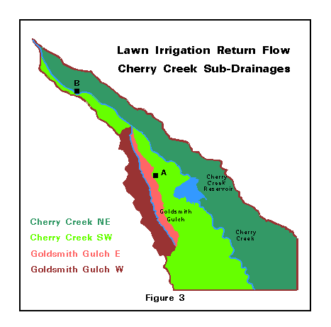
It was important that each cell's distance to stream and distance to drainage boundary were calculated relative to the proper stream reach and drainage boundary line. In many cases, cells that were returning to one stream were actually closer to the other, or, similarly, many cells were closer to an inappropriate drainage boundary than to their own drainage boundary. For instance, in Figure 3, cell A is closer to Goldsmith Gulch than to Cherry Creek, but its distance to stream value must reflect that it is in an area that is returning to Goldsmith Gulch. And cell B is closer to the western edge of the Cherry Creek drainage, while its distance to drainage boundary must reflect that it sits on the eastern side of the Cherry Creek.
To account for this, each of the two basins were processed separately when calculating distance to stream and each of the four sub-basins were processed separately when calculating the distance to drainage boundary. In each case, the basin or sub-basin was built and grids representing the linear stream or drainage boundary feature were built using combinations of ARC RESELECT, LINEGRID, or POLYGRID commands. Distances from the basin grid cells to the grid of the stream or drainage boundaries were calculated using the GRID function COSTDISTANCE. Once distance values were computed for all of the component pieces, all pieces were put together using the GRID function MERGE.
Once distance to stream and distance to drainage boundary were calculated, a grid was created storing an estimate of drainage width. This was built by adding the distance to stream values to the distance to drainage boundary values.
3. Creating Image Well Distance Grids
Once actual distance to stream and distance to drainage boundary values were calculated, it was possible to calculate hypothetical distance to stream values for all ten image wells. Each of these image well distances, or XN values, were stored as separate grid layers. As displayed in Figure 2, the hypothetical distance to the stream for the first image well can be calculated by the equation
X1 = (2 * W) - X
where:
X = distance from well (cell) to stream
W = estimated width of drainage
X1 = hypothetical distance to stream for image well 1
Thus, within GRID one can multiply the width of drainage grid by 2, and then subtract the actual distance to stream grid values to build a grid of hypothetical distances to streams for image well 1.
Similarly, hypothetical distance to stream grids can be built for the remaining nine image wells using the following equations:
X2 = (2 * W) + X
X3 = (4 * W) - X
X4 = (4 * W) + X
X5 = (6 * W) - X
X6 = (6 * W) + X
X7 = (8 * W) - X
X8 = (8 * W) + X
X9 = (10 * W) - X
X10 = (10 * W) + X
4. Creating Glover Return Flow Factor GRIDS
After a set of Glover numbers is generated for an area, they are used for any beginning month and any beginning amount of deep percolation water. Regardless of which month is used as the beginning month and regardless of the deep percolation water amount, the return flow factor for month 1 will always remain constant for an area, as will the return flow factor for month 2 and all subsequent months. For this study, each GRID cell functioned as it's own separate "area". Only a change in the base hydrogeological data (which would change the value of the alpha variable) or a change in how the drainage system was defined (which would change distance to stream or distance to drainage boundary) would change Glover return flow factors for a given GRID cell.
The approach used to calculate Glover numbers required solving the equations described earlier in the report, each of which was programmed into a set of AML-driven map algebra equations using GRID algebra. In summary, for each well or image well, a value was calculated for Z. From the Z value, an error function value was retrieved and a value for q/Q was subsequently derived. Then, q/Q was used to derive v/V. The v/V values, one for each well and one for each image well, were then combined and used to calculate the return flow factor for the month being analyzed.
Each of the equations had to be run for each month and return flow factors for months 1 through 208 were required. The first set of equations and processes, indeed the bulk of what is presented below, were run on each well and each image well for each month. The second set of procedures served to summarize results for a given month.
4.1 Individual Well and Image Well Calculations
The following calculations were performed on the well grid and each of the 10 image well calculated distance grids for each of the 208 months for which Glover return flow factors were required.
The GRID algebra equation used for calculating alpha (Equation 3) was:
ALPHA = ( SAT4-CC * HDC4-CC ) div VDR4-CC
where
SAT4-CC = grid of saturated thickness
HDC4-CC = grid of hydraulic conductivity
VDR4-CC = grid of specific yield or "void ratio"
The GRID algebra equation used for calculating the Z value (Equation 5) was:
ZN-M = XN div (sqrt (4 * ALPHA * (M * 30.417)))
where
ZN-M = GRID of Z values for well N in month M
XN = GRID of distance to stream for wells or image
wells
ALPHA = GRID of Alpha variable values
M = Number of month being processed
The GRID representing Z values was used to calculate q/Q. As described above, a critical concept in deriving q/Q is that of "the error function". In essence, the value of q/Q can be calculated as follows:
q/Q = 1 - The "Error Function" of ZN- M
Hence, to calculate q/Q it was necessary to calculate the error function of all Z values. The mathematical approaches to calculating the error function, presented in Equations 2 and 4, were examined and proved impractical if not impossible to program using GRID algebra. And while many calculators and spreadsheets have the ability to generate "the error function" of a number, GRID does not currently have "the error function" as a GRID function.
The approach chosen to retrieve the error function value was to use the GRID RECLASS command along with a remap table of all potential values of Z and all their corresponding error function values. Error functions were required of all Z values less than or equal to 2.9, as all values of Z greater than 2.9 returned an error function value close enough to 1 that q/Q was effectively calculated to 0. It was determined that all potential thousandth numbers between .0001 and 2.9000 needed error function values in the remap table, as tests run using a remap table with all hundredth numbers between .001 and 2.900 gave erroneous results when the rounded error function results were carried through to subsequent mathematical processing steps.
Hence, an INFO remap table with 29001 records was built. Error function values for all numbers from .0000 to 2.9001 were generated using the EXCEL spreadsheet package, and the values were used to populate the remap table. Due to the fact that the in_item of the remap table required integer data and that the output of RECLASS must be an integer GRID, the REMAP table actually contained input values multiplied by 10,000 and output values multiplied by 1,000,000,000. The actual values of Z were manipulated prior to use with RECLASS and the RECLASS output GRID was manipulated after the RECLASS operation to calculate the proper output numbers.
The pre-RECLASS manipulation of the Z values consisted of multiplying all values by 10,000 and rounding all numbers. Additionally, all values greater that 2.9 were set to 29,001. The GRID command that performed the manipulation was:
ZKN-M = con (int ((ZN-M * 10000) + 0.5) <= 29000, ~
int ((ZN-M * 10000) + 0.5), 29001)
where:
ZN-M = GRID of Z values for well N in month M
ZKN-M = GRID of manipulated Z values for well N in
month M, ready for use with RECLASS
After this manipulation, RECLASS was run on the ZKN- M GRID, with results being placed in a GRID named ERFB N-M. As the ERFBN-M GRID contained error function values multiplied by 1 billion, the following post-RECLASS manipulation was performed to create a floating point GRID of actual error function values:
ERFN-M = (float (ERFBN-M )) div 1000000000
where:
ERFN-M = GRID of error function values for well N in
month M
ERFBN-M = GRID of manipulated error function values for
well N in month N
Using the error function values, q/Q was derived by subtracting error function values from 1 with the following GRID command:
QQN-M = 1 - ERFN-M
where:
QQN-M = q/Q values for well N in month M
Once q/Q values were calculated for a well/month, it was possible to calculate v/V for the well/month by programming Equation 6 into the following GRID equation.
VVN-M = (QQN-M * (1 + (2 * (sqr (ZN-M) )))) - ~
((2 * ZN-M * (exp (- sqr (ZN-M) ))) div (sqrt (PI) ))
where:
VVN-M = v/V values for well N in month M
4.2 Monthly Return Flow Factor Summations
After all v/V values were processed for a grid of the wells and the 10 grids of image wells, the 11 v/V values were combined based on the following equation:
SVVM = VV0-M + VV1-M - VV2-M - VV3-M + VV4-M + VV5-M ~
- VV6-M - VV7-M + VV8-M + VV9-M - VV10-M
where:
SVVM = Sum of v/V values for month M
This overall monthly value of v/V was then multiplied by the number of the month being processed as follows:
TSVVM = M * SVVM
where:
TSVVM = Time adjusted sum of v/V values for month M
After deriving TSVV for any month, the total cumulative amount of water which had returned to the stream through the month being processed was calculated. This cumulative returns value is the total percentage of water, applied in month 1, that had returned to the stream in all months up to and including month M. In the first month processed, the cumulative stream return was equal to the value of TSVVM. In all subsequent months, the cumulative return amount was equal to the TSVV value for the month being processed minus the TSVV value for the previous month as follows:
CRM = TSVVM - TSVV(month previous to M )
where
CRM = Cumulative returns for month M
And, finally, after cumulative return amount had been calculated, the return flow factor for the month was calculated. The Glover return flow factor was equal to that percentage of the cumulatively returned water which returned in month M. In month 1 the return flow factor was equal to the cumulative return value. In all subsequent months the return flow factor was calculated by subtracting the cumulative returns for the month prior to month M from the cumulative returns calculated for month M as follows:
RFFM = CRM - CR(month previous to M)
where:
RFFM = Glover Return Flow Factor for month M
4.3 Verifying Glover GRID AML equations
Steps 1 through 4 above resulted in a set of Glover return flow factors for a set of months. The results from the AML program were compared to results obtained from two other sources.
Results for one grid cell of hydraulic conductivity, saturated thickness, specific yield, distance to stream and distance to aquifer boundary were calculated using the Excel spreadsheet package as well as a BASIC program developed by the Colorado State Engineers Office. A set of grids were developed in which all cells had the single values used in the spreadsheet and BASIC program. The AML and GRID programs were run to assure that the results from GRID matched the results from the other two programs.
This process allowed for the correction of several minor GRID logic errors. This process also allowed for two key adjustments to the way the process was run. Through calibration it was discovered that the GRID remap table which returned error function values required 29,001 values, returning values accurate to the thousandth versus a 2,901 value remap table returning values to the hundredth. It was also through calibration that the number of image wells was increased from 4 to 10.
5. Creating Monthly Irrigation Application Amount GRIDS
Before calculating the amount of irrigation water returning to the stream network it was necessary to build GRID datasets of the amount of deep percolation water applied within the study area. The period of time analyzed was from September 1976 through December of 1993.
Deep percolation water was divided equally among all GRID cells comprising Denver Water distributor areas within the study area. As Denver Water distributor areas were comprised of 6,442 100 meter GRID cells, each monthly application amount was divided by 6,442 and the result moved to a GRID representing the amount of water applied for each month using the following AML and GRID commands:
&s eachcell [CALC %amt% / 6442]
app-MM-YY = con [sab4-cc == 1, %eachcell%, 0]
where:
amt = Deep Percolation Water in month MM of year YY
app-MM-YY = GRID of Deep Percolation in month MM of year YY
6. Creating Return Flow Amount GRIDS
Once Glover return flow factors for 208 months and deep percolation data for 208 months had been processed into GRID datasets, it was possible to estimate the amount and timing of irrigation water returning to the stream system.
When summarizing the water that was returning in any month, it was necessary to sum the water returning to the stream from all previous months. Hence, if calculating the amount of water returning to the stream in November of 1976, the third month of the study period, it would be necessary to do the following:
A. Multiply the grid of water applied in November of 1976 by the grid of return flow factors for month 1.
B. Multiply the grid of water applied in October of 1976 by the grid of return flow factors for month 2.
C. Multiply the grid of water applied in September of 1976 by the grid of return flow factors for month 3.
D. Add the grid created in steps A through C to calculate total amount of water returning to the stream in November of 1976.
Hence, when calculating return flow amounts for December of 1976, November application amounts would be multiplied by return flow factors for month 2, as opposed to return flow factors for month 1, as in the example above. An AML was developed which stepped back through all months previous to the month being calculated and multiplied each month's deep percolation amount by the appropriate return flow factor. Return amounts for each of the 208 months of the study period were calculated and the results were reviewed for total return amounts as well as for the pattern or timing of returns.
Conclusion
Techniques for quantifying water returning to a stream as a result of lawn irrigation were automated using ArcInfo GRID tools. The method developed by Denver Water using GRID in combination with analytical equations described by Glover (Glover 1977) was applied to the lower Cherry Creek basin in metropolitan Denver. Calculations were based on aquifer saturated thickness, specific yield, and hydraulic conductivity, in combination with distance to stream and width of the aquifer. Lawn irrigation data and Glover return flow factors were then used to determine irrigation return flow patterns over a 17-year period. Results from the modeling effort provided a set of irrigation return flow numbers used to calculate the timing and amount of return flows which are used when claiming and re-using water.
References
Glover, Robert E., 1977, Ground-Water Movement: Water Resources Publication, Engineering Monograph No. 31, U.S. Bureau of Reclamation.
Hamilton, Judith L., and Owens, Willard G., 1972, Geological Aspects, Soils and Related Foundation Problems, Denver Metropolitan Area, Colorado. Colorado Geological Survey, Department of Natural Resources, State of Colorado.
Hillier, Donald E., Schneider, Paul A. Jr., and Hutchinson E. Carter., 1983, Depth to the Water Table (1976-1977) in the Greater Denver Area Front Range Urban Corridor, Colorado. Map I-856-K, Department of the Interior, U.S. Geological Survey.
Jenkins, C.T., 1970, Computation of Rate and Volume of Stream Depletion by Wells: Techniques of Water Resources Investigations of the United States Geological Survey, Book 4, Chapter D1.
Peters, Robert S., 1994, Cherry Creek Basin Lawn Irrigation Return Flow Study: Engineering Report, Case No. 89CW198, Water Division 1, Denver Water.
Powers, J.P., 1981, Construction dewatering: a guide to theory and practice; John Wiley and Sons.
Shroba R.R., 1980, Geological Map and Physical Properties of the Surficial Bedrock Units of the Englewood Quadrangle, Denver, Arapahoe, and Adams Counties, Colorado. Map GQ-1524. Department of the Interior, U.S. Geological Survey.
Schreoder, Dewayne R., 1987, Analytical Stream Depletion Model, Ground Water Publication No. 1, Office of the State Engineer, Colorado Division of Water Resources.