Department of Geography and Earth Resources, and National Biological Survey, Utah State University, Logan, Utah, 84322-5240. voice (801)797-2792, fax (801)797-4048, E-mail gapcd@nr.usu.edu
Gap analysis is a US Department of Interior, National Biological Service program to define and map the diversity of terestrial animal species. Gap Analysis is an approach to examining the current status of biodiversity management and provide information necessary for evaluation of current status. It uses GIS to identify "gaps" in biodiversity protection that may be filled by expanding the preserve system or changing land use practices where applicable (Edwards et al 1993). In using GIS in Gap analysis a great deal of information was collected as ancillary and primary data. The storage and retrieval of the data becomes cumbersome and data requests from interested users take a great deal of time and resources.
As the process of the Utah Gap Analysis proceeded, the need for a well managed, accessible database available to the user community was obvious. Before the completion of the analysis, data requests from various users filled one full-time technician's time. Writing selected data to tape for a single user takes a great deal of resources. Thus, the need for a cheaper more readily accessible database.
CD-ROM seemed a logical choice, as they can store a great deal of information in a relatively instant retrievable form. Other options were explored, such as the internet, but the data had to be compressed and then stored on hard disk. Internet serving of the data is also limited by the speed at which large data sets can be retrieved. To download a subset of the database would take a great deal of time and, even when it arrived at the users site more time would be spent importing the data. Also, not everyone has access to the net so data requests would still require resources. Therefore, the decision was made to provide the data in CD-ROM form.
Data provided in the process of Gap Analysis has many applications but they do not reduce to a single definitive set of results. Applications are all directed to questions of biodiversity, and the management of land for the conservation and protection of sensitive, threatened, or endangered species. Obvious users of the data are land planners, land managers, and policy and decision makers who are responsible for the stewardship of the nations natural resources.
A majority of users would be managers of federal lands. In these cases concerns will be directed towards land that is specifically owned and/or managed by these agencies, therefore, a definition of ownership is important. In many cases, especially in the western states, land holdings are large and are managed in areas defined by the agencies, such as forests, districts, and resource areas.
Other users of the Gap Analysis data set include local planning units defined by the State of Utah. Not all of these users require data at the same scale nor the same land areas. It has become apparent that for many state agencies, counties and city planning areas are important management units. Gap data must therefore be available in this regional format. Federal agencies managing large areas of land often use standard national topographic map sheets and have data systems based on these sheet lines. Gap data must therefore be available in this format, also.
Questions asked by potential users will necessarily include the definition of suitable habitats for selected species. In the case of the Utah Gap Analysis a total of more than 500 vertebrate species have been identified along with their habitat requirements. The costs and the logistics of producing individual habitat and range maps for each species exceed the capability of conventional publication systems if detail is to be available at all planning levels. Different applications require different combinations of information for different areas.
With this need for flexibility in data presentation, the appropriate technology was deemed to be a GIS for the Utah Gap Analysis. The cost of maintaining a full GIS in order to use the Gap Analysis data was to high for this to be a realistic option for the majority of potential users. The solution attempted here is to create a CD-ROM containing a series of selected data layers and simple display, query, and copy functions. The challenge is to design a limited series of interactive functions that will produce suitable answers for a majority of potential users. Because the State of Utah uses ArcInfo software for the State Geographic Information Database (SGID) this prototype product has been created in ArcInfo to conform to the standard practices of the State.
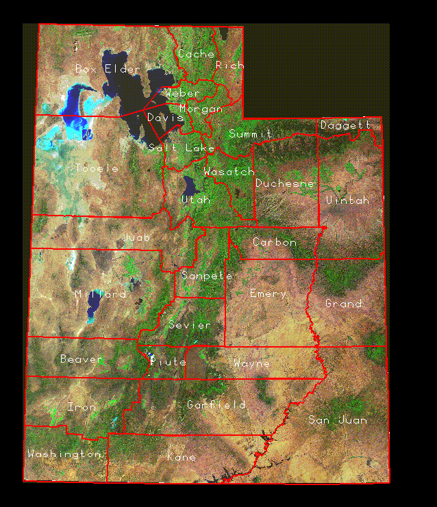
Initially the design of the CD-ROM must provide access to basic data. This prototype design is based on statewide maps of land ownership, land cover-types, communications, hydrology, administrative boundaries, and other components of the topographic map of the state. For illustrative purposes a state-wide overview of the landscape is provided from Landsat Thematic Mapper (TM) data. This information can be viewed and queried at a statewide level, giving an effective scale of approximately 1:3,000,000 on a 20 inch display screen.
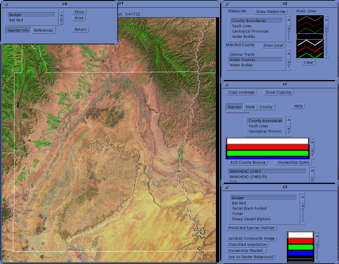
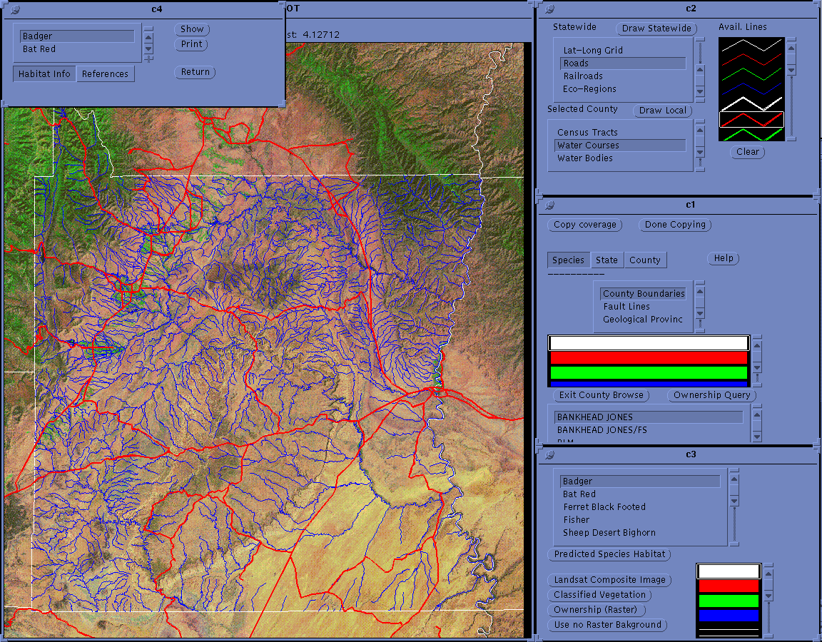
This ability to view the landscapes is particularly useful if the satellite overview is presented at the county level. Figure 1 shows the statewide overview with county boundaries. By using "point and click" menus the user simply places the cursor on the county of interest and "clicks" the appropriate button to obtain county data as shown in Figure 2 for Emery County. Once the county has been selected overlays of such features as stream courses (Figure 3), roads, or other topographic features can be added as desired. At either level, roads, stream courses, vegetation types, or other chosen themes can be overlaid on the basic data.
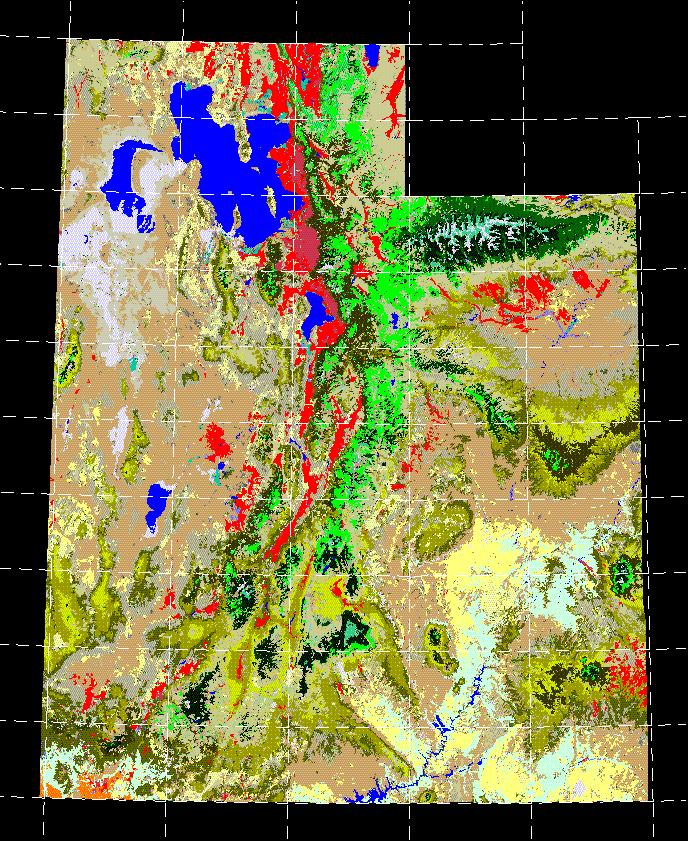
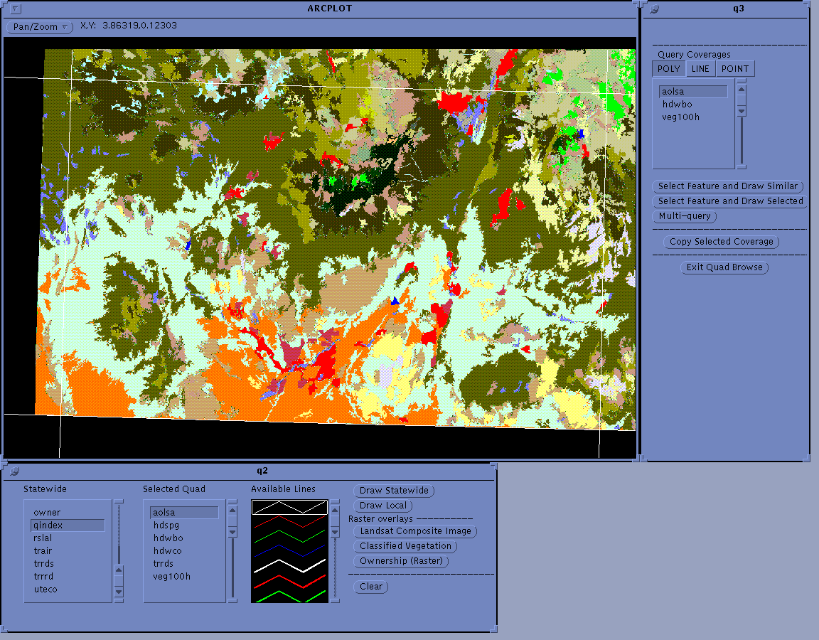
For a detailed analysis based on Gap data a user may wish to view the vegetation types as shown in Figure 4. Overlaid on this display is the white line grid showing the sheet lines of the USGS 1:100000 map series for the State of Utah. By selecting a single sheet using the "point and click" menu as described above, data can be presented for a selected 1:100000 map sheet area. Figure 5 shows the data for the St. George 1:100,000 sheet in south western Utah, an area that includes parts of Washington County. The vegetation shown is that of the 34 cover-types found in the state of Utah under the UNESCO classification scheme. Each polygon has a description that is given in the data dictionary including the precise decision steps that define it. The coverages contained on the two CDs are in ArcInfo format and the GUI is a series of AMLs. The development of the Cds in this format was guided by the format in which the data was collected and analyzed. Since the Gap Analysis for the State of Utah was done using ArcInfo in combination with ERDAS software. it was logical to develop the GUI in compatible format. The following sections describe the setup of the system, and detailed descriptions of the two CD's in their respective sections.
The basic setup for your system may differ slightly from the following explanation. If you have questions direct them to your system administrator. First, you must mount the cdrom. For instance on a SUN.
mount /cdrom
Once the CD-ROM is mounted you must set a variable. Again for the SUN:
setenv GAPHOME /cdrom/gap
Now you are ready to run the programs and Graphical user interface on the CD-ROM from
anywhere on your system. This allows you to use the applications if you start ARC from a
directory in which you have read and write permissions. To run the GAP CD_ROM you must
first start ARC in a directory that you have read and write permissions. At the ARC prompt:
ARC: &r $GAPHOME/gogap
If you are going to run the GUI many times you may want to copy the gogap.aml from the CD-ROM to the directory you wish to run the GUI.
The GUI uses two system commands! This is important to you as you will have to set up an alias for these two system commands. They are:
cp -- Which is the copy function within our system.
lpr -- Which is the print function within our system.
To use any of the documentation or other print and copy options you must set up an alias for these. Ask your system administrator for more information.
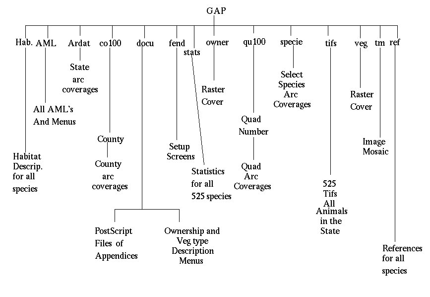
For those in the PC environment, you will not be able to run the GUI. We developed this prototype for the UNIX environment as the first attempt to disseminate GAP data. The good news is that the data and the documentation is compatible for PC's. To access the data contained on the ROMs you may use PC ARC or Arcview software. The documentation , in most cases is in Postscript format along with ascii, so that you may print these out. A directory structure is provided so you will know how to access this information (Figure 6). Further releases of this data, if any, will hopefully be more compatible with the PC environment.
The GUI starts out with some set screens for the edification of the user. These screens will automatically be called. The last screen has a menu in the lower left corner of the display window. The two buttons allow you to continue using the image as a background or not. Using the image will slow the run time down as it is a large file to be pulled from your CD-ROM drive. If you are just starting out it is suggested that you use the image as a background to give you a reference of the state. If you already have familiarized yourself with the GUI you may want to speed up the run time by switching the image off. Once you select a button a window will appear followed by a select browse menu.
The Select browse menu gives you five browse options. These options will launch you into the selected browse capabilities. These include state, 1:100000 quad, county, species, and documentation browse capabilities. Each of these will be discussed in detail so that you can use the GAP GUI effectively.
Upon clicking on the state browse button the state capability menu will appear. This capability select allows you to select one or a number of capabilities to proceed with the browse of the state data.
The menu contains two scrolling lists, a symbol select list, and buttons to select a background raster coverage. The upper left scrolling list contains a list of randomly selected species that can be drawn to the screen. These are examples of the wildlife habitat modelling. The purpose of this is purely for demonstration purposes. The second CD explained in Chapter 2 contains the entire species habitat models for the state. To look at the predicted species habitat you must click on the species of interest, select a shade symbol from the symbol scrolling list, and then click the 'Predicted Species Habitat' button.
The second scrolling list contains all the unique land ownership and administration types for the entire state. The codes contain the owner/administrator. For example private land within a Forest Service administrative boundary would have the code PRIVATE/FS. For more explanation of the code structure see Appendix X. To select and shade a particular ownership you must click on the owner of interest, select a shade type from the symbol scrolling list, and finally click on the 'Ownership Query' button.
The four buttons on the bottom are used to select a background for your query session. To select a background just click on the desired background button.
The remaining button on the top of the menu will return you to the capabilities set menu.
This menu provides you with selected ARC coverages to either display or copy. The menu contains a scroll bar for coverage selection, a line symbol scroll bar, and several buttons. To draw a coverage to the screen you must select a directory either 'Species' or 'State General Coverages', click on the coverage you provides a visual inspection of the data.
To copy any of the coverages in the scroll list, select a coverage, and click on the 'Copy Coverage' button. At this point you will need to type in the full pathname to the directory you wish the coverage to be copied. You MUST have read and write permissions to this directory. Once you have typed in the correct path hit a return in the menu. A window will appear and if the copy is successful the copied coverage will appear. To continue copying coverages select another coverage and click on the 'Copy Coverage' button.
The 'Clear' button will clear the screen so that you may view a different set of coverages. To return to the capability set menu click on the 'Return to Capability Set' button.
This menu contains four buttons and a warning. Map Builder Must Be Run in Order!! The order is from left to right and if the order is not followed the program will issue a series of error messages.
The map production menu allows for the compilation of maps in two formats, ArcInfo 'gra' files, and postscript 8 1/2 by 11 maps of the composition.
To begin the map composition click on the 'Begin Map' button. This will invoke a help menu that explains what you will need to do to continue. Click on the 'Continue' button and designate a work directory. You must have read and write permissions to this directory. Next you will have to name your composition. The name of the composition must be unique.
At this time anything you draw to the screen will be added to the map composition. Before any coverage or query is drawn to the composition it is suggested that you clear the display. While drawing to the screen remember that map elements can not be deleted.
After all the elements to the map are displayed, click on the 'Finish Map' button. This button starts the building of an UTM grid, a scale bar, and a north arrow. When finished the program will ask you if the map is acceptable. If it is click the 'Yes' button. If the map is unacceptable click the 'No' button, which will automatically delete your map composition.
If you saved your map composition and wish to print it, click on the 'Make Printable Map' button. The menu initiated by the button allows you to choose the output type you prefer. Click on the appropriate format and the map will be processed automatically. This does not make the hardcopy, it only produces the file that may be printed.
The fourth button returns you to the capability set menu. If you hit this button before you click the 'Finish Map' button you should re-initiate the map production menu and run the finish map programs, otherwise the map will continue to receive elements until the GAP Gui is no longer running. This can create very large files as everything display is retained in the open map composition.
The species habitat documentation menu contains a scrolling list of species, a habitat information or references selection, a print button, a show button, and a return button.
The scrolling list contains the species that coincide with the species in 'Ownership and Species Query' menu previously discussed. To view the habitat information select a species, and click the 'Habitat' selection then click on the show button. A popup window will appear. The information in these files is directly related to the references. The numbers in the habitat references column coincide with numbers in the reference file. To view the references click the 'References' selection and then click ont the 'Show' button. The number at the front is the reference code. These references were used in determining the habitat needs of the species.
To print the information contained in these two files click the 'Print' button. This will print these files to your default printer for further examination.
The quad browse selection is designed to display and query the data at the 1:100000 standard quad sheet level. The capabilities are much more complex in nature than the statewide browse. One aspect that increases the complexity is the availability of vegetation polygons. At the state level the vegetation is to large and complex to be converted to polygons even at the 100 hectare size. The availability of vegetation polygons allows for a new suite of query possibilities.
The quad browse capabilities menu is comprised of a set of background buttons, and eight capabilities from which to choose. The background set buttons work exactly like the same suite of buttons as described in the statewide browse section. The eight capabilities will be discussed in detail in their own section below.
The species and ownership query menu contains two scrolling lists, a symbol scrolling list, and three buttons. To preform an ownership query, select an ownership category from the left scrolling list, select a symbol, and click the 'Do Ownership Query' button.
The species query is accomplished in basically the same manner. Select a species from the right scrolling list, select a symbol, and click the 'Do Species Query' button.
The 'Return to Capability Set' button returns you to the quad capability set menu.
The utility of this menu should not be overlooked. While the menu is not as self- explanatory or user-friendly as others in the quad browse capabilities, it has a great deal of importance to anyone wishing to do more detailed analysis of the data than the GUI can provide.
The menu consists of two sections that work together so that any coverage that is available to display in the quad capabilities can be copied to your hard drive. The top section consists of a scrolling list of 'currently' available coverages, and two buttons. To copy a coverage from the scrolling list, select a coverage, and click the 'Copy' button. this will initiate a menu in which you designate the full path of a directory you wish to copy the coverage. A display window will appear and display the coverage copied. You may continue to copy coverages from the list by clicking on them and repeating the above procedure.
The second section contains three buttons which act as pointers to associated directories. You may continue copying coverages from any of these directories to your hard drive until you have all the coverages for you to continue with your own analysis.
This menu contains two scrolling lists, a line symbol scrolling list, draw buttons, a clear button, and raster background buttons.
To draw a coverage from the left (statewide) scrolling list, select a coverage, select a line symbol, and click the 'Draw Statewide' button.
To draw a coverage from the right (Quad) scrolling list, select a coverage, select a line symbol, and click the 'Draw Local' button.
The 'Clear' button blanks the display which allows you to display many different sets of coverages over the selected raster background. The raster background can be reset by using the raster overlay buttons.
This menu contains five buttons , which allow you to identify polygons on the display. A polygon or polygons with the same attributes can be shaded and described.
To do a query of ownership, click on the 'Query Quad Ownership' button. Click on the type of query you would like to perform, either 'Select Feature and Draw Similar' or 'Select Feature and Draw Selected'. Once you have made a choice of query type a menu will appear giving you further instructions. To continue click the 'Initiate Cursor' button. It takes a few moments for the arcs to draw to the screen so be somewhat patient. Once the cursor appears in the display window click on the left mouse button in the desired polygon. Depending on the query type you have selected, the polygon or multiple polygons will be shaded. A menu describing the type of land ownership selected will appear. To return to the main menu click on the 'Return' button.
The query of the vegetation polygons works in the same way as the ownership and follows the same steps. The menu describing the Vegetation polygons contains a description of primary and associated species of the cover type.
This menu contains a scrolling list containing every habitat type occurring in the state. It also contains a scrolling list of shade symbols, a veg query button, and a return button.
To determine the spatial extent of a particular habitat type within the selected quad, select the vegetation of interest, select a shade symbol from the scrolling list, and click the 'Do Veg Query' button. The vegetation polygons will be shaded and a menu describing that particular vegetation type will be displayed.
The map output capabilities for the quad browse work exactly like the state browse map output capabilities. The difference is in the scales that are output. The quad browse outputs maps at either 1:100000 standard map sheets, or 8 1/2 x 11 postscript files. To run this section please refer to the Map Output Capabilities section of the state browse documentation.
Refer to the state browse section for use of this menu since it is exactly the same in every aspect.
The county browse section of the CD-ROM is a little different than the other browse capabilities. When the selection of a county has occurred the program launches all the capabilities that are available at the county level. Each menu that is launched and their functionality will be described in detail in their own section.
This menu contains two scrolling lists for available coverages, a scrolling list for line symbols, and three buttons. To draw a statewide coverage from the upper scrolling list, click on a coverage of interest, select a line symbol from the line symbol scrolling list, and click the 'Draw Statewide' button. To draw a coverage to the screen from the lower scrolling list, click on a coverage of interest, select a line symbol, and click on the 'Draw Local' button. To clear the screen to draw a different set of coverages click on the 'Clear' button.
This menu contains two distinct sections. The upper section is for copying coverages from either the state, the county, or the species directories on the CD-ROM. The lower section allows you to do ownership queries.
To copy coverages from the ROM to your hard drive, select a directory from which to copy . You have three choices, 'State Coverages', 'County Coverages', and 'Species'. The scrolling list to the right of the select directory buttons, contains a list of the actual coverage names in the directory. Although these are somewhat cryptic you can refer to the Draw coverages menu for explanation of the coverages. To copy select a directory, click on the coverage you want to copy in the scrolling list, and then click on the 'Copy Coverage' button. The GUI will then ask you for a path to a the directory you want to copy the selected coverage to. Type the full path in and hit return. A Copied coverage window will appear and once the coverage is copied it will draw the coverage in that window. To continue copying coverages select a directory, select a coverage, etc.
To execute an ownership query from the lower section of the menu, select a ownership type of interest from the scrolling list, select a shade symbol, and click the 'Ownership Query' button.
This menu contains a scrolling list of selected species, a scrolling list of shade symbols, and five buttons. To draw a species predicted habitat, click on the species of interest, select a shade symbol and click the 'Predicted Species Habitat' button. The four remaining buttons are used to change or select a raster background for viewing the data.
The TIFF browse section is provided to view predicted species habitat for all 525 species found in the state of Utah. These provide a quick view of species that are of interest to the user. The tiff views of the species are also linked to statistics and documentation of each species.
When the species browse is initiated by clicking on the 'Species' button of the select browse menu a menu containing a choice bar will appear that allow you to select species from four different categories; Mammals, Amphibians, Birds, and Reptiles. The menu also contains a scrolling list of the current list of species, and several buttons.
To display the predicted habitat of a species select a species from the list and click the 'Distribution' button. The references, habitat, and statistics for that species can be viewed by clicking the appropriate button. The suite of copy buttons allows you to copy any of the files viewed to your work area. When one of these buttons are clicked you must tell it where to copy, as in numerous other menus described above. The 'Postscript Doc.' button allows you to copy the entire selected species group postscript file to your directory. This gives you all the species at one time within the group, unlike the copy buttons, which only give you the selected species documentation. These documents are the appendices for the final report that is included with this package.
The documentation button on the select browse menu invokes a menu that allows you copy particular documents of interest to your work area. The menu contains buttons for all the appendices associated with the final report. To copy these files to your work area click on the document of interests associated button. A menu will pop up that asks you to enter a name and path for the document to be copied into. Once a valid name and path are entered the documentation will be copied. The 'Species Habitat and References' button contains one extra step. Upon clicking that button another menu pops up. This menu allows you to select the group and document you want to copy. Once you select the document the process will proceed as above.
CD-ROM is an effective way of distributing the Utah Gap Analysis data. This format includes the flexibility to present data in many scales and levels of detail. CD-ROM format also allows for quick access to the data in a form that is readily available to the user.
The design of the CD-ROM data sets provides for the user to view data at a statewide level or by county or standard 1:100,000 map sheets. This allows the use of the database by different user groups such as county planners, resource agency personnel, or state agencies. The level of detail that is required for management decisions at the state and local level are provided in a logical database that is stored in a retrievable format.
Data layers include land ownership, vegetation (land/cover), and topographic information (roads, streams, elevation, etc.). With this combination of information, the data allows and facilitates the use of the data for further analysis. This will support the goals of Gap analysis in providing the information to make informed decisions for the protection of biodiversity.
Interactive data queries include animal habitat, vegetation, and land ownership to define areas of concern for sensitive, threatened, and endangered species. This capability is fundamental in the planning process for many agencies so that species habitat can be assessed to avoid potential problems in the area of management.
Models of habitat type for each of the 525 vertebrate species in the state of Utah provide a capability to create potential habitat maps of counties, 1:100,000 map sheets or the whole state for each species, or any group of species. A task not realistically performed using conventional mapping methods.
Evaluation of this CD-ROM product is in the field-testing stage. The initial responses have been very positive in most cases. There seems to be a little misconception about PC compatibility. The data contained on the ROMs is compatible with the PC environment but, the GUI can not be used. The logical next step, if any, would to provide an easily accessed PC interface, or customized ArcView projects on the CD.
The delivery of the Utah Gap Analysis Product in CD-ROM format is a highly effective way of delivering the large data set produced by this effort. In this format it allows the intuitive user to think through the database and solve specific problems. The final report, and the four maps included in the package add to the functionality by providing background information for addressing the specific problem of the user. Allowing free and easy access to the Utah Gap Analysis data in this format may alleviate misunderstandings between agencies and the public so that biodiversity management can proceed in a manner beneficial to all.
Edwards, T. C., Jr., J. M. Scott, C. G. Homer, and R. D. Ramsey. 1993. Gap Analysis: a geographic approach for assessing national biological diversity. Natural Resources and Environmental Issues 2:65-72.