ABSTRACT: The economic losses caused by the Midwest Flood of 1993 and previous floods have increased the need to consider alternative schemes for managing the Missouri River Basin. A flood impact decision support system (FIDSS) is developed in St. Charles County to identify impacts that flooding will have on local communities and surrounding land use activities. The objective of FIDSS is to significantly reduce the learning curve by developing a customized graphical user interface that is tailored to floodplain management needs. ArcView and Avenue programming language are used to customize FIDSS for users with diverse, non-technical backgrounds. Citizen committees, established in the wake of the flood, are involved in the development of FIDSS and provide feedback for tailoring the system to their needs. For ease of use, the menu appearance and program functionality are consistent across all menus. FIDSS will include on-line help and feedback for guiding the users in making better decisions.
INTRODUCTION
The Midwest Flood of 1993 was the most devastating flood in U.S. history. Damages have been estimated at $12-16 billion with an additional $6 billion expended for flood response activities. Several government agencies, organizations and public interest groups have expressed reservations about traditional ways of managing the upper Mississippi River and lower Missouri River. Currently, there is considerable public support for considering alternative management schemes for these river systems as evidenced by the formation of groups such as the Greenway Network, Inc., Gateway Trailnet and the Missouri River Communities Network.
The U.S. Army Corps of Engineers is currently involved in a Floodplain Management Assessment to evaluate the potential economic and environmental effects of alternative floodplain management schemes for the Upper Mississippi River Basin (1994). The Corps plans to “identify promising alternatives, or combinations of alternatives, that appear to meet the floodplain management goals of reduced risk [of flood damages], maintenance and enhancement of environmental values, and economically efficient use of floodplain resources.” The Corps points out that this approach to management involves a “range of structural and nonstructural alternatives that can be considered to modify either the floodplains themselves or the economic and social uses of the floodplains.” Their study is not addressing community- level economic and environmental impacts of the schemes.
To date, there have been no comprehensive studies of the economic and environmental impacts of various management schemes for the Missouri River. The Food and Agricultural Policy Research Institute (FAPRI) estimated the agricultural economic impacts on producers and local and state economies of not repairing 355 levees. Not repairing the levees would reduce the value of crop production by $96 million which is estimated to result in a $208 million loss in economic activity and the loss of 3,300 jobs in Missouri. FAPRI did not consider levee repair costs and environmental consequences. In another study in Saline County, Missouri, FAPRI determined that the highest net economic benefits in the floodplain are achieved by farming conventional crops with levees restored to their pre-flood locations and continuation of federal deficiency payments (Center for National Food and Agricultural Policy, 1994). This study did not consider the economic benefits of converting flood-prone agricultural land to uses other than crop production.
While floodplain management is widely supported, the spatial information on socioeconomic and geophysical processes needed for comprehensive evaluation of alternative floodplain management plans is not readily accessible to local decision makers. Advances in remote sensing, geographic information systems (GIS) and map processing software, multiple objective decision making, simulation modeling, and risk management make it possible to develop and implement user-friendly, interactive, decision support systems (DSS) for floodplain planning and management.
OBJECTIVES
The objective of this paper is to highlight efforts made in incorporating GIS technology into the citizen decision making process in the wake of the Midwest Flood of 1993, based on three studies being conducted in St. Charles County, Missouri. The upsurge of interest in floodplain management and planning caused by the flood has increased the demand for user friendly, interactive methods that land planners and managers can use to evaluate the economic and environmental consequences of alternative management schemes. There are many citizen and governmental groups in St. Charles County who are interested and willing to cooperate in the development and evaluation of integrated floodplain management schemes.
This paper addresses the process of introducing and customizing ArcView for citizen groups affected by the flood and outlines the methodology for creating a basic flood impact decision support system (FIDSS) based on citizen input. Specifically, FIDSS will be customized for users with diverse, non-technical backgrounds. The graphical user interface will guide decision makers through a series of menus depending on what scenarios they want to analyze. FIDSS will also include on-line help and feedback for guiding the users in making better decisions.
The three studies present unique challenges and opportunities for providing decision making tools to the general public. Unlike the more traditional research-oriented GIS studies, these public- oriented studies offer challenges which include acknowledging varying perceptions about flooding, strong emotions (anger, despair, distrust of public officials) and a substantial computer literacy gap. However, the opportunities include providing a science-based approach to floodplain management and the ability to narrow the computer literacy gap by providing a simple graphical user interface (GUI) with on-line help that is specifically designed for addressing floodplain management issues.
STUDY AREA
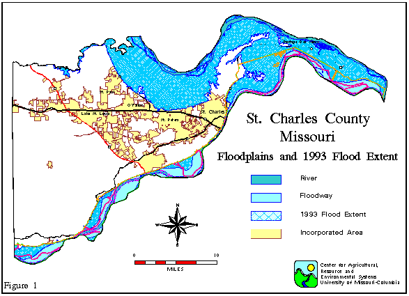
St. Charles county, west of St. Louis, Missouri is one of the fastest growing counties in Midwest. For this reason, the potential benefits of reducing damages from future floods are high. St. Charles has been selected as the project site for several reasons. First, the county, which is bordered by the Missouri River on the south and the Mississippi River on the north, has a history of severe property damages from flooding. Presidential Disaster Declarations were issued in 1973, 1982, 1986, 1993 and 1994. Flood frequency averages once every other year, with a major flood episode occurring once every six years on average. At the peak of the Midwest Flood of 1993, over 35% of St. Charles county was inundated (see Figure 1). While different groups in the county have discussed numerous approaches to reducing flood damages, these approaches have not been translated into coherent floodplain management schemes which are supported by affected parties and the general public. One of the obstacles to developing well-supported schemes is the general lack of information regarding the economic and environmental impacts of alternative schemes.
FLOOD STUDIES
The Center for Agricultural, Resource and Environmental Systems (CARES) is conducting three flood-related studies for St. Charles County. These studies are at various stages of completion: (1) the University of Missouri Extension Service - completed; (2) Greenway Network Inc. - ongoing; and (3) Mcknight Foundation - just initiated. The studies, detailed below, highlight the process of introducing and customizing ArcView for citizen and offers the methodology for creating FIDSS based on citizen input.
University Extension Study
The University Extension study involved compiling all existing digital layers for St. Charles County in order to have a complete set of information for the flood recovery effort. The primary objectives of the study are to: (1) verify the accuracy of existing data and GIS layers; (2) establish these layers on a personal computer (PC) using ArcView; and (3) demonstrate to local users how ArcView can be used in floodplain management. CARES anticipated ArcView to be used by different groups in the county to improve their understanding of the county’s natural resource base and make more informed decisions regarding flood impacts.
The first task in providing data and digital layers was to ensure that an adequate personal computer was available to run ArcView. A University Extension agronomy/natural resources management specialist was able to obtain a PC that met all the requirements to run ArcView for the citizen committee meetings. The Esri-St. Louis regional office donated a copy of ArcView to the University Extension for the purpose of displaying the layers obtained by CARES for flood-related use. CARES also produced a series of ArcInfo-generated wall maps. These maps were displayed at public meetings. CARES encouraged people to use ArcView as the maps displayed on the walls were based on information provided on the University Extension PC.
Existing data, developed by CARES, the Geographic Resources Center (GRC) at the University of Missouri-Columbia, and other state and federal agencies (i.e., Missouri Department of Conservation and USGS) was compiled for the extension study. The GRC has conducted several projects for St. Charles County. These projects include: (1) Spatially referencing land-based information for the Master Task Force Land Use Committee (1987- 1989); (2) digitizing the Natural Resource Conservation Service soil survey for St. Charles county (1986); (3) digitizing Federal Emergency Management Agency (FEMA)-related layers (October 1991). Existing digital layer include: elevation, urban boundaries, soils, fire stations, census tract attributes, 100 year floodplain State Emergency Management Agency (SEMA) flood insurance rate maps, the 500 year flood extent, the 1993 flood extent, levees, geology, lakes, streams, roads, railroads, dams, landfills, zip codes, watershed boundaries, wellheads, river intakes, school district boundaries, and parcel boundaries.
CARES personnel spoke at public meetings and discussed how ArcView can be used for floodplain management. Given the nature of the existing layers (scales ranged from 1:24,000 to 1:500,000) the issue of scale and the appropriate use of the layers with respect to their scales was stressed. Despite the layers being made available on a PC for public access, there was little interaction with ArcView. The learning curve required to use ArcView appeared to be too great for the majority of people at the public meetings. Although the requirements for this study were met, CARES was concerned about the lack of hands-on use of ArcView and the potential misuse of layers with varying scales if ArcView were used. This concern is addressed in the second and third studies below by customizing ArcView with its object- oriented programming language - Avenue.
Greenway Network Study
CARES is engaged in a US Environmental Protection Agency study funded by Greenway, Network Inc. Greenway Network is a citizens group located in St. Charles County. Their mission is to facilitate the management of the county’s floodplains, to identify nonstructural alternatives for floodplain management and to provide leadership in the implementation of a comprehensive, community-supported floodplain management plan.
The study makes use of the existing layers obtained from the University of Missouri Extension Service project as well as new data sources. Specifically, a review is being made of data compiled by the Scientific Assessment and Strategy Team (SAST) and released by the White House Office of Science and Technology Policy (Interagency Floodplain Management Review Committee, 1994). SAST was formed through a directive from the White House Office of Science and Technology to develop and provide information to support the decision making process regarding both nonstructural and structural approaches to river basin management and provide advice and assistance to Federal officials responsible for making decisions with respect to flood recovery in the Upper Mississippi River and Missouri River Basins (USGS, 1995). The team developed an Environmental Information System for the basins at the EROS Data Center. The system includes: elevation data, satellite data, digitized aerial photographs, soils, data on historic river channels, etc. (much of these data can be accessed via INTERNET).
Greenway Network is holding public meetings on non-structural alternatives for floodplain use in towns around St. Charles County. A compiled list, based on these public meetings where citizens brainstormed a list of non-structural alternatives, includes: (1) land use management - regulation and zoning, (2) elevate and floodproof structures, (3) maintain floodplain as open space, (4) watershed management, greenways and wetlands restoration, (5) reform flood insurance program, (6) flood forecasting and planned emergency response, (7) master plan for floodplain, (8) reservoir management for flood control, and (9) woody corridors. CARES personnel spoke at these meetings and ArcView was used with an LCD flat panel projector to demonstrate how GIS can be used to address only some of these non-structural alternatives. Due to data limitations some non-structural alternatives could not be considered, while other non-structural measures required the incorporation of sophisticated hydrological models. Given the appropriate funding these issues could be addressed in a GIS.
In order to help the task force visualize some of the non- structural alternatives, CARES is using Avenue to customize ArcView. Avenue is used to: (1) develop customized graphical user interfaces, (2) build new functionality for end-user- specific applications, (3) simplify tasks for end-users, and (4) link ArcView to other applications (Esri, 1994). A graphical user interface (GUI) includes buttons and menus which allow the user to select parameters and evaluation criteria needed to run FIDSS. A menu provides an interactive interface for entering all the parameters needed to execute a complex operation (Esri, 1993). A user’s first impression of an application is based on the appearance of the GUI. Since FIDSS is designed for users with diverse, non-technical backgrounds, the graphical appearance of buttons, menus and program functionality is simple and consistent.
The view and table document GUIs and the project GUI are modified by using the customize dialog box in Avenue. The dialog box is used to customize control sets - menus, buttons and tools. The control editor within the customize dialog box is used to strip existing menus, menu items, and buttons and add new menus, menu items, buttons and separators in order to simplify the GUI for task force needs. The control properties for these control sets are set with Avenue scripts (i.e. the click and apply properties) and other properties including: cursor, disabled, help, help topic, icon, invisible, tag, and label (note: the control properties list varies depending on which control set is being modified).
The help control property, when updated, is used to display a help string in the status bar of the Application window. For example, a button was created in the view document GUI to run a script that automatically imports ArcInfo export files and adds the themes to a view. By placing the mouse cursor over the ArcInfo import button, a help sting appears in the lower left corner of the Application window stating: “Imports ArcInfo files (*.e00) and adds the themes to a view.” The help topic control property, when updated, is used to display on-line help for the customized controls created. For example, a standard WinHelp file is created to provide end users with a discussion and detailed procedures for importing ArcInfo files and adding the views to a theme (WinHelp is distributed with Microsoft Windows). The help file can be accessed either through the “search for help on...” menu item in the help menu or by using the context- sensitive help where the control is clicked on with the help tool (or F1 key).
CARES will continue to develop a basic FIDSS by modifying the GUIs and simplifying operations based on input from Greenway Network, the task force, and the general public. The challenging aspect of this study is to work with people who have little or no understanding of GIS and narrow down the compiled list to those alternatives that are suitable for study in a GIS.
McKnight Foundation Study
CARES recently received funding from the McKnight Foundation to develop a user-friendly decision support system (modified FIDSS) for evaluating the potential economic and environmental impacts of alternative management schemes for the floodplains of the Missouri and Mississippi Rivers in St. Charles County. Schemes will be identified in cooperation with local agencies and citizens groups in St. Charles County who are interested in reducing flood damages and enhancing the health of riverine ecosystems. Besides offering a user-friendly way of evaluating floodplain management schemes, FIDSS will increase user awareness of the interaction between economic and environmental systems. This has two benefits. First, it expands the users’ knowledge regarding the complexity of floodplain management issues. Second, it improves the users’ appreciation of the tradeoffs in developing a comprehensive floodplain management plan. Since The McKnight Foundation study is just underway, this section offers the methodology for enhancing FIDSS based on the work completed in the first two studies.
A DSS is a knowledge-based computer program which integrates data, information and models for the purpose of identifying and evaluating solutions to complex problems involving spatially distributed information (Djokic 1993). Lentz (1991) points out that a DSS should be designed to assist decision makers in performing their task. Potential benefits of a user-friendly, interactive DSS for water resources planning were identified by Loucks and Fedra (1987). They note that, unlike traditional off- line, non-interactive approaches, an interactive DSS allows a user to evaluate solutions based on his/her own objectives and subjective judgment in an interactive learning and decision- making process. A DSS assumes that the user is not an expert in database management or economic/environmental modeling.
A DSS is superior to conventional non-interactive approaches to water resources planning and floodplain management. In non- interactive approaches, alternative floodplain management schemes are evaluated using an integrative model that embodies certain data, assumptions and procedures. Study results are made available to potential users through published reports, conferences and press releases. Users of the information are not involved in evaluating and viewing the data, selecting the evaluation criteria, conducting the evaluation and interpreting the results. In other words, non-interactive studies do not get users involved in the evaluation process. As a consequence, users tend to be skeptical about the results. The floodplain studies by FAPRI and the COE mentioned earlier are examples of non-interactive studies. A non-interactive approach is of limited value to local users who are interested in knowing how different kinds of information and different preferences for economic and environmental criteria influence the selection of floodplain management schemes.
Development of a user-friendly DSS for St. Charles County will allow local users to evaluate and compare alternative floodplain management schemes based on their own subjective judgment, goals and objectives in an interactive learning and decision-making process that makes extensive use of computer-generated maps and data. Maps are an excellent way for decision makers to visualize and understand the spatial relationships among landscape elements as well as the spatial economic and environmental impacts of alternative watershed management plans. For these reasons, the most advanced decision support systems incorporate GIS.
CARES will initiate an economic assessment by establishing an economic baseline for evaluating the impacts of alternative management schemes. A baseline is needed before alternative scenarios can be addressed. This baseline will serve as a reference point for evaluating the impacts of alternative floodplain management schemes on income and employment in key sectors, expected flood damages, local government expenditures and tax revenues. The baseline and deviations from the baseline associated with a particular floodplain management strategy will be estimated using the IMpact analysis for PLANning (IMPLAN) model. The IMPLAN model was developed by the U.S. Forest Service. It is a menu-driven computer program that performs non- survey regional input-output analysis of any county or combination of counties in the U.S.
FIDSS will evaluate the environmental consequences of alternative floodplain management schemes. The evaluation will consist of determining how each scheme influences various environmental indicators. Indicators will include items such as: expected duration and frequency of flooding and its beneficial or detrimental effects on riverine ecosystems; proportion of floodplain devoted to land uses that promote ecosystem protection and restoration (such as expansion of wetland acreage or development of greenbelts); compatibility of non-ecological activities, such as agricultural, urban and commercial development, with ecological processes; likely improvements in soil and water quality, wildlife habitat suitability of floodplains, and others. FIDSS will allow users to select indicators from a menu or to construct new indicators using various combinations of the indicators provided by FIDSS. To maximize the usefulness of the environmental evaluation, potential users will be asked to define the environmental indicators they would like to use in evaluating alternative floodplain management schemes.
CARES will modify the FIDSS created in the second study by incorporating IMPLAN and the environmental indicators into the DSS by using Avenue to communicate with IMPLAN. The McKnight Foundation study is in its infancy. Much work remains to be done on the economic and environmental components before they can be effectively incorporated into a DSS. Nevertheless, once these components are established, the capabilities of transferring data and instructions to external programs within a customized ArcView session can be realized.
CONCLUSIONS
The objective of this paper is to highlight efforts made in incorporating GIS technology into the citizen decision making process in the wake of the Midwest Flood of 1993, based on three studies being conducted in St. Charles County, Missouri. The paper addresses the process of introducing and customizing ArcView with its object-oriented programming language - Avenue - based on citizen input. The three studies serve as a narrative for introducing GIS technology to citizen groups and outlines the methodology for a flood impact decision support system for decision makers. These studies present unique challenges and opportunities for providing decision making tools to the general public.
Coordinated management of a river corridor requires the simultaneous consideration of environmental and economic interrelationships and impacts. In order to address these considerations, it is necessary to integrate a large amount of information and knowledge from several disciplines. To be useful, the information must be made available to decision makers in a rational and user-friendly framework. Ultimately, FIDSS will enable users to access data and effectively evaluate floodplain management plans and policies.
ACKNOWLEDGMENTS
The authors wish to acknowledge Bob Miller of the University of Missouri Extension Service and Candy Boyd Suffern of Greenway Network for helping us present our work at the sometimes emotionally charged public meetings in St. Charles County.
REFERENCES
Center for National Food and Agricultural Policy. 1994. An Economic Analysis of Floodplain Management Options, Saline County, Missouri, A Pilot Study, Columbia, MO, June 15.
Djokic, Dean. 1993. Towards General Purpose Spatial Decision Support System Using Existing Technologies. Paper presented at the Second International Conference/Workshop on Integrating Geographic Information Systems and Environmental Modeling, September 26-30, Breckenridge, CO.
Environmental Systems Research Institute, Inc. (Esri). 1993. ARC Macro Language: Developing ArcInfo Menus and Macros with AML. Redlands, California.
Environmental Systems Research Institute, Inc. (Esri). 1994. Customizing ArcView with Avenue. Redlands, California.
Fedra, Kurt, et al. 1993. Decision Support and Information Systems for Regional Development Planning. International Institute for Applied Systems Analysis, Laxenburg, Austria.
Interagency Floodplain Management Review Committee. 1994b. Science for Floodplain Management into the 21st Century. Preliminary Report of the Scientific Assessment and Strategy Team, Washington, D.C., June.
Lentz, Wolfgang. 1991. Decision Making and Expert Systems: A Comparison. In Economics and Artificial Intelligence in Agriculture. Proceedings, 26th Seminar of the European Association of Agricultural Economists, ONA-PG, Centre de Grignon, France, September 10-12.
Loucks, D.P. and K. Fedra. 1987. Impact of Changing Computer Technology on Hydrologic and Water Resources Modeling. Review of Geophysics 25(2):107-112.
U.S. Army Corps of Engineers. 1994. Floodplain Management Assessment of the Upper Mississippi and Lower Missouri Rivers and their Tributaries, Plan of Study. Department of the Army, Minneapolis, MN, April 29.
US Geological Survey. 1995. About the Scientific Assessment and Strategy Team - SAST Dataset List. EROS Data Center, Soux Falls, SD. Obtained via World Wide Web: htp:/edcwww.cr.usgs.gov/test/sast/dslist.html.