The objectives of the National Water-Quality Assessment (NAWQA) program are to assess the sta tus and trends of water-quality conditions throughout the Nation and to link the status and trends to an understanding of factors that affect water quality. The ArcInfo1 Geographic Information System has played a key role in achieving these goals and is being used as a tool for spatial-analysis applications in this multidisciplinary project, which includes physical, chemical, and biological studies.
ArcInfo was used to manage a large water-quality data base and to produce publication-quality graphics. This tool has been used for comprehensive analyses of data, efficient storage and retrieval of a large relational data base, and dilivery of study-unit findings to the water-resources community in a timely manner.
* The use of trade, product, industry, or firm names is for descriptive purposes only and does not imply endorsement by the U.S. Government.
During 1991, the U.S. Geological Survey (USGS) implemented the National Water-Quality Assessment (NAWQA) program. The South Platte River Basin was among the first 20 study units selected for study to help assess the quality of the Nation's water resources. A long-term goal of the national program is to describe the status and trends in the quality of a large part of the Nation's water resources and to provide a sound, scientific understand ing of the primary factors (both natural and anthropogenic) affecting the water quality. Sixty study units across the United States make up the national program.
Sixty to seventy percent of the Nation's total water use and population served by public water supplies lie within these study-unit boundaries. A principal design feature of the NAWQA program is the integration of water-quality information at different areal scales. The physical, chemical, and biolog ical water quality conditions within the study unit basin are directly dependent on the environmental setting. GIS has been useful in analyzing and storing the spatial data required to better understand the effects of environmental factors on water quality of the South Platte River Basin. The GIS used was versions 6.1.1 and 7.0.2, products of Environmental Systems Research Institute, Inc., on Data General Aviion workstations.
The purpose of this paper is to present how ArcInfo has been used to analyze, interpret, store, and present data used in the South Platte River Basin NAWQA study unit and how it has increased efficiency and productivity within the study unit.
ArcInfo was used to accomplish two objectives of the surface-water investigations: (1) to identify, describe, and explain the major factors affecting surface-water quality, and (2) to estimate loads of selected water- quality constituents at key locations along the South Platte River and its tributaries. To accomplish the first objective, detailed land-use coverages were needed, especially along river buffer zones. Using GRID, the cell-based geopro cessing software of ArcInfo, information about land use was interpreted from LANDSAT Thematic Mapper (TM) image data that were classified using the SPECTRUM software written by Khoral Research Institute (KRI).
Clustered image data were input into SPECTRUM, which classifies the clusters on the basis of spectral reflectance; therefore, the software only classifies land cover. For example, in SPECTRUM, the reflectance of an irrigated alfalfa field in an agricultural area can be the same as an irrigated golf course in an urban area; both the alfalfa field and golf course, therefore, will be classified as the same land-cover unit (that is, irrigated grassland). The same was true for water and shadows; to the satellite, both water and shadows absorb energy and reflect very little back to the satellite sensors. Because information on land use was required, and not land cover, the classification of both the alfalfa field and the golf course as the same unit posed a problem. To overcome this problem and interpret the cor rect land use from the classified land-cover data, the SPECTRUM image was transferred to GRID.
Broad land-use classification (urban, agriculture, forest, and so on) was interpreted from areal photography, and cells were assigned a value of NODATA (a GRID specific value) to restrict the data set to a single broad class of land use, such as urban areas. The land-cover classes identified in SPECTRUM were used to assign the correct land uses in the urban areas (transportation, commercial, residential, and so on). This process was repeated for the other broad land-use classes to get the final composite grid of land-use classification. To achieve the second objective of estimating loads for water-quality constituents, a flow-routing model was created for a stream network. The lengths of individual reaches and the locations of points of water input to and output from the river were required. To accomplish this, a digital representation of river mileage was needed.
The linear modeling commands within ARC and ARCEDIT, collectively called Dynamic Segmentation, were used to create the mileage system and "superimpose" this model on the line coverage of streams. The mileage systems are continuous for each stream and are independent of the from/to node data structure of the individual arcs. The arcs for the stream coverage were taken from U.S. Geological Survey 1:100,000 Digital Line Graphs (DLG's) and the U.S. Environmental Protection Agency River Reach 3 files. An item named MILES was added to the arc attribute table (AAT) of the stream coverage and calculated in miles from the length, in meters, of each arc.Using the ARCEDIT commands SEL PATH and MAKEROUTE, individual stream mile systems were created for the South Platte River main stem and many of its tributaries. Mileage values for each of the input/output points along the river were obtained using the ARC command ADDROUTEMEASURE. These values were then used as input into a stream-water flow model.
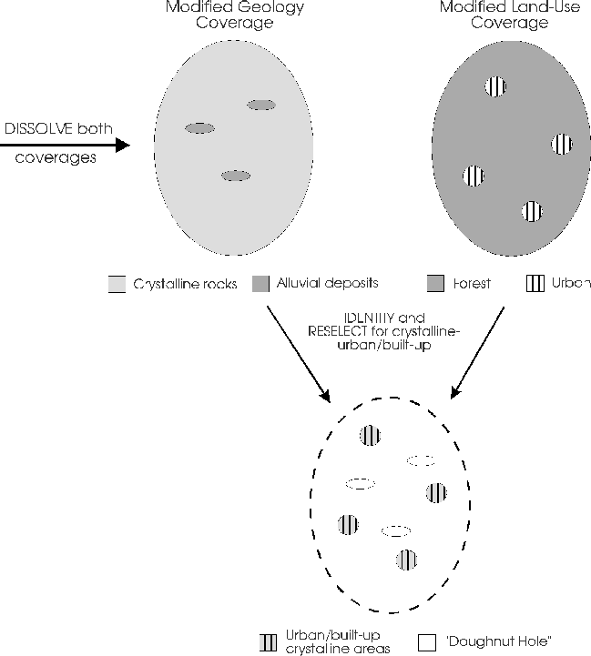
One of the objectives of the South Platte River Basin ground-water study was the characterization of the gen eral water-quality conditions of major hydrologic settings in the basin. To avoid bias in the evaluation of the resource, well-sampling sites in the different hydrologic settings were selected randomly using a selection program written in Arc Macro Language (AML) by Scott (1990). This AML requires an input polygon coverage of areas of interest. For purposes of this activity, a polygon coverage of urban/built-up areas in the mountains that also were underlain by crystalline rock was required. To create this coverage, the ARC command DISSOLVE was used to simplify the number of polygons in both the geology and land-use coverages. The ARC command IDENTITY was then used to merge the two coverages. The ARC command RESELECT was used on the resulting coverage to select polygons, which were classified as both urban/built-up land use and crystalline rock.
Because the selection program requires only the selected polygons, and not the bounding polygon, a problem surfaced with respect to "doughnut hole polygons" that were present in the modified crystalline geology polygon coverage. These doughnut holes were empty interior holes where something other than crystalline rocks (alluvial, sedimentary rocks, and so on) were present during the reselection from the geology coverage. These polygons were not classified as either urban/built-up or crystalline bedrock so no interference occurred with the reselection of the other polygons. Because there was a problem with the doughnut hole polygons not being closed polygons, labels could not be cre ated and the polygons could not be reselected with the ARC RESELECT command; therefore, it was easier to remove the bounding arcs manually in ARCEDIT (Figure 1).
Figure 1. Occurrence of "doughnut hole" polygons after selection of crystalline-urban/built-up polygons.
A principal objective of the biology study in the South Platte NAWQA project was to identify biological communities, describe their condition, and relate this information to assessing water quality. Habitat is an example of a factor studied that affects biological communities. Because habitat must be considered in the interpretation of water-quality effects on biological communities, detailed habitat measurements were made.
To assist in tracking changes in channel morphology, the Triangular Irregular Network (TIN) software product of ArcInfo was used to represent surfaces of stream channels and their flood plains based on surveying data collected in the field. The surveying instrument used, with the use of associated software, created an ASCII coordinate file that was manip ulated slightly and input into ARC in the point GENERATE format.
A file containing elevation information for each data point and the user-defined codes used to identify geomorphic features associated with each data point was edited to include INFO commands at the top of the file.ARC was started and the command file executed using a UNIX redirection: arc61 < filename. This process loaded the elevation and code information into the INFO file automatically. The ARC command JOINITEM was then used to join this INFO file to the coverage point attribute table (PAT). Once the elevations were in the PAT, the ARC command CREATETIN was used to create a tin.
The surface was plotted in ARCPLOT by using SURFACEDRAPE commands.The surface was then rotated into dif ferent perspectives using the ARCPLOT commands SURFACEOBSERVER and SURFACETARGET to deter mine the best observation points. Survey data points were color coded (according to what feature they represented) using the ARCPLOT RESELECT command and then plotted on the surface using the ARCPLOT command SUR FACEDRAPE.
For example, edge-of-water points were plotted on the surface in red, points surveyed on islands were plotted in green, points surveyed on gravel bars were plotted in grey, and so on. Other channel geomorphic features such as riffles, pools, and runs were digitized as polygons and also plotted on the surface using SURFACE DRAPE.
All of the spatial data and some of the water-quality data required for analyses in the South Platte River Basin study were stored within ArcInfo. The spatial data were stored in coverages by theme, and the chemical data resided either in coverage attribute files or in related INFO files. Because ARCPLOT map composer can project "on-the-fly," one projection is used for all coverages in the data base; therefore, multiple iterations of the coverages (for overlying on base maps of different projections) were not required. Coverages are stored in separate directories by data type and content.
For example, under the top-level directory called gis are the subdirectories called basec ovs (line coverages), ptcovs (point coverages), landuse, dems (U.S. Geological Survey Digital Elevation Models), and dlgs. The ARC relational data-base structure allowed the efficient storage of both spatial and chemical data for the large number of monitoring sites in the project. Instead of creating separate coverages for many different activ ities, one large point coverage was created to contain all surface-water sites. These sites were reselected with the use of the ARC RELATE command based on many different criteria, such as which activity the site was used for and any chemical data associated with that site that were stored in related INFO files.
The South Platte River Basin study required "on demand" reports and presentations. To produce these graph ics, the ARCPLOT map composer was used. This was efficient because the output was produced in the same appli cation in which the spatial and water-quality data were stored. AML's were created to produce each figure in map composer, which was edited interactively after the AML finished running. Both the ARCPLOT graphics canvas and a text window running a text-editing program on the AML were displayed simultaneously on the screen. The display of the cursor coordinates on the ARCPLOT canvas was useful for immediate modification of the AML in the text window.
This technique was used to produce a report (Dennehy and others, 1995) in which all of the figures from the GIS, including the cover for the report, were generated in map composer from AML's and saved as post script files. These postscript files were then imported directly into FrameMaker, merging the graphics with the report text (Figure 2).
Graphics and text from the graphics package CorelDRAW also were imported into ARC PLOT. This made the combined plotting of coverages, text, and nonspatial graphics fairly simple in ARCPLOT. Color slides also were produced directly from ARCPLOT map composer by correctly specifying the PAGESIZE in the AML to fit the specifications of the imaging camera, usually a 2:3 ratio of hight to width. Producing these figures and slides with the use of ArcInfo eliminated the need to reproduce these figures in other graphics pack ages.
Figure 2. Examples of graphics created in ArcInfo and inserted electronically into a report.
GIS was used in many aspects of the National Water-Quality Assessment Program's South Platte River Basin study. ArcInfo was a valuable tool in the South Platte NAWQA study simplifying work tasks, increasing anal ysis capabilities, and assisting in the production of graphics. The capabilities of ArcInfo facilitated the studies in many ways. The cell-based processing module GRID was used to produce detailed land-use information from LANDSAT land-cover imagery data in buffer zones along rivers.
Linear modeling with Dynamic Segmentation was used in surface-water studies to produce river mileage for a flow-routing model of transportation of water- quality constituents in the river and its tributaries. In ground-water studies, ArcInfo overlaying capabilities were used for analyzing different theme coverages, such as geology and land use, to help select well sites in a ran dom manner.
The surface representation capabilities of TIN and ARCPLOT were used in the biology studies to assist in monitoring changes in channel morphology by producing surfaces of stream channels and surrounding flood plains and by producing plots of stream cross sections. In addition to spatial analysis, ArcInfo was used to manage a large water-quality data base and to produce publication-quality graphics. Figures and slides were cre ated directly from the ArcInfo data base, which greatly enhanced productivity. These several applications improved capability to analyze data in a timely manner and distribute it to to our customers.
Dennehy, K.F., Litke, D.W., McMahon, P.B., Heiny J.S., and Tate, C.M., 1995, Water-quality assessment of the South Platte River Basin, Colorado, Nebraska, and Wyoming--Analysis of available nutrient, suspended-sediment, and pesticide data, water years 1980-92: U.S. Geological Survey Water-Resources Investigations Report 94-4095, 145 p.
Scott, Jonathon C., 1990, Computerized stratified random site-selection approaches for design of a ground-water-quality sam pling network: U.S. Geological Survey Water-Resources Investigations Report 90-4101, 109 p.
Sharon Lisa Qi, Hydrologist
U.S. Geological Survey, Water Resources Division, Colorado District
Box 25046, MS 415, Denver Federal Center
Denver, CO 80225
Telephone: (303) 236-4882, Fax: (303) 236-4912
E-mail: slqi@usgs.gov