Melisa M. McLean
For the past three years, the Illinois State Geological Survey has conducted a project to compile geologic information and produce a series of geologic maps to assist officials in McLean County with landfill screening. This project has utilized geographic information system software, ArcInfo, and contouring and modeling software, Interactive Surface Modeling (ISM) and Geologic Modeling Program (GMP), from Dynamic Graphics, Inc. ArcInfo was used to compile a digital surface topography coverage from 1:24,000 topographic information. Lithologic information from well driller's logs was compiled into an INFO database. Cross sections of the lithologic data from the database were constructed and reviewed for geologic consistency. Bedrock elevation information was extracted from the database and used to generate a bedrock topography coverage. The lithologic data were used as input to create a three-dimensional model of the subsurface with GMP. The surface topography and bedrock topography coverages were converted to ISM two-dimensional grids and used to create a map of the thickness of Quaternary deposits; they were also used as the top and bottom of the three-dimensional model. Several contour maps were created from the model including a series of depth slice maps showing sand and gravel thickness in 50-foot intervals below the ground surface and a cumulative sand and gravel thickness map. Geologists analyzed the surface topography, bedrock topography, Quaternary deposits thickness and sand and gravel thickness coverages to construct a map showing areas which, due to geologic limitations, should be avoided in landfill screening. This paper will present an overview of the processes involved in constructing geologic maps and discuss the importance of these maps for landfill screening.
The Illinois State Geologic Survey (ISGS) is involved in a program administered by the Illinois Department of Energy and Natural Resources' Office of Recycling and Waste Reduction to assist county officials in landfill screening. The program is available on a cost-share basis to participating counties, and it's purpose is to provide geologic maps that indicate the natural properties and setting of Quaternary deposits that determine the capability for hosting a landfill. Areas overlying potential groundwater resources or having a high sand content have a geologic limitation for hosting a landfill and would be ranked as having a low capability. Geographic information system software from Esri, ArcInfo (versions 6.0 and 6.1), and modeling software from Dynamic Graphics, Inc., Interactive Surface Modeling (version 7.1) and Geologic Modeling Program (version 5.0), were utilized in this project. Major steps in the ISGS mapping program include producing a ground surface topography map, compiling a geologic database, producing and analyzing geologic cross sections, producing a bedrock topography map, producing a thickness of Quaternary deposits map, creating a three-dimensional model of the subsurface geology, producing a series of depth slice maps showing the thickness of sand and gravel within 50-foot intervals below the ground surface and producing a cumulative sand and gravel thickness map. Geologic information was compiled from these maps to create a landfill capability map showing areas ranked from high to low capability for hosting a landfill. These steps are discussed below.
A surface topography coverage of McLean County was needed to assign elevations to lithologic units in the database, to create the map of the thickness of Quaternary deposits and to function as the top surface of the three-dimensional model. For a discussion on creating a digital surface topography refer to McLean, 1993. In order to compile digital surface topography information for the county, the ISGS entered into a work-share agreement with the U.S. Geological Survey (USGS), where the USGS scanned topographic lines from thirty-three 7.5-minute quadrangles encompassing McLean County and provided the data to the ISGS. Using ArcInfo, the ISGS edited the linework and assigned elevations according to USGS digital line graph standards. Line coverages of the topographic lines for the thirty-three quadrangles were created, and the ARCPOINT command was used to convert the line data into point data. ASCII files of x, y (location) and z (elevation) data were created from the point coverages and used as input for the Interactive Surface Modeling (ISM) software to create two-dimensional grids of the surface topography for each quadrangle. Contour lines were generated with ISM for each quadrangle; and plots of the generated contour lines were compared with the published USGS topographic maps. Contour line errors were corrected to ensure that the elevation values produced from the grids were within 10 feet of the elevations shown on the USGS maps. After corrections were made, the thirty-three grids were combined in ISM to produce a grid of the surface topography of the county. Contour lines were output from ISM and used to create a surface topography coverage. To create a map that best represents the ground surface topography in the county, the lines produced by the ISM software were edited with ArcInfo to delete problem polygons created by extrapolation (Figure 1).
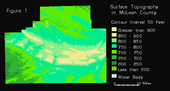
The surface topography in McLean County ranges from greater than 925 feet above mean sea level in the east central portion of the county to less than 625 feet above mean sea level in the southwestern portion of the county. The most prominent features on the surface are arcuate end moraines that formed near the southern margin of the Laurentide Ice Sheet between about 20,000 to 17,000 years ago during the last glacial episode (Wisconsin). The end moraines represent ice-marginal positions of the Lake Michigan Lobe, a lobe of the ice sheet that flowed into Illinois from the Lake Michigan basin. Sand and gravel deposits may occur along the moraine front as outwash deposits; they may also occur within the moraines due to glacial ice overriding outwash deposits as the ice advanced. These outwash deposits may be groundwater resources or act as pathways to groundwater resources and should be avoided for landfill siting.
The geologic maps and three-dimensional model produced for this project are based on databases of geologic information. For a discussion on designing the database refer to Denhart (1993). Information from over 1,600 well drillers' logs of water wells, coal tests, oil and gas tests, engineering borings and wells drilled by the ISGS was compiled into two INFO databases. One file contained information such as the driller's name, property owner's name, well location and well type for each well, and another file contained a record for each lithologic unit in each well, including the well driller's description, thickness and depth to the top and bottom of each unit.
Each lithologic unit was classified by grain size or lithology. Units were categorized as fine- grained (e.g. clay, silt), coarse-grained (e.g. sand, gravel), bedrock (e.g. shale, limestone) or indeterminate, where no description of the unit or a vague description was provided by the well driller. Grain size of geologic units is an important factor in landfill screening as coarse-grained deposits may represent groundwater resources or conduits to groundwater resources and fine- grained deposits may inhibit the migration of contaminants. The elevation of the top bedrock unit is also important as bedrock valleys may contain large sand and gravel deposits.
Many quality control checks were run on the databases to eliminate mistyped information. For example, an INFO program was run to ensure that the bottom depth of an upper unit equaled the top depth of the next underlying unit. Other programs were run to look for non-rock units below rock units, units with zero thickness and wells with no unit information.
An in-house FORTRAN program was used to calculate x and y coordinates in Lambert feet for each well, based on the Public Land Survey System (PLSS) of section, township, range, section quarters and any other location information provided on the well drillers' logs. An ASCII file of well number and x and y values was input into ISM and compared with the two-dimensional grid of the surface topography to determine the surface elevation of each well. Based on the surface elevation, the elevation of the top and bottom of each lithologic unit was calculated in the INFO database. For a discussion of interpolating well elevations refer to Riggs et al (1992). A point coverage containing each lithologic unit location and elevation information was created from the INFO files using the GENERATE command.
An INFO program and an AML program were used to construct line coverages of cross sections of the lithologic data within each well in each row of east-west PLSS sections and each column of north-south PLSS sections in the county. The cross sections are based on the x, y and z data obtained from the point coverage of lithologic units. The INFO program created an ASCII output file that was used to generate a line coverage for each row and column of PLSS sections. Each line in the coverage corresponded to a lithologic unit in a well. The cross section coverages were displayed and reviewed in ARCEDIT to identify lithologic inconsistencies, erroneous lithologic interpretations, well location errors or mistyped well driller's descriptions. Corrections were made in the original database, and the point coverage of the units and the cross sections were regenerated. Analyzing the cross sections was an important step in this project not only to correct errors in the database but also to assess the geologic framework of the county.
In order to create a map of the bedrock topography in McLean County, the database was queried to select the top unit of the bedrock surface in each well reaching bedrock. For another discussion on creating a bedrock topography refer to Abert et al (1992). An ASCII file containing an x, y and z value for each top bedrock unit was created, and used to create a two-dimensional grid (in ISM) of the topography of the bedrock surface. An ASCII file of the x, y and z coordinates of the bottom unit of wells not completed in bedrock was compared with the bedrock topography grid to ensure that the gridding process had not extrapolated the topography to elevations higher than the bottom unit in those wells. The x, y and z coordinates from these wells were added to the ASCII input file and used to force the bedrock surface to lower elevations where necessary. Contour lines were output from ISM and used to create a bedrock topography coverage. To create a mapthat best represents the topography of the bedrock surface in the county, the contour lines were edited to eliminate unsupported polygons, or polygons where no data existed, and problem polygons created by extrapolation (Figure 2).
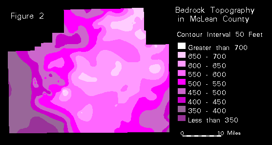
The topography of the bedrock surface in McLean County ranges from greater than 700 feet above mean sea level in the central portion of the county to less than 350 feet above mean sea level in the south and western portions of the county. The most prominent bedrock features are large bedrock valleys in the west and southeast portions of the county. The presence of bedrock valleys is important in landfill screening as they contain large deposits of sand and gravel which are potential groundwater resources.
The bedrock surface within the county consists primarily of Pennsylvanian-age limestone, shale and coal. In the extreme eastern edge of the county, Mississippian-age limestone and Upper Devonian shale can be found at the bedrock surface (Willman, et al, 1967). Bedrock is not being used as the primary water resource in the county. Only one town in the county has water supply wells in bedrock, however the bedrock units supplying the water are more than 1,500 feet below the surface.
To determine the thickness of Quaternary deposits in McLean County, the distance between the elevations of the ground surface topography grid and bedrock surface topography grid was calculated in ISM. The ground surface and the bedrock surface form the upper and lower boundaries of the Quaternary deposits, and the difference between the elevations of the two surfaces represents the thickness of those deposits. The grid of the bedrock topography was subtracted from the grid of the ground surface topography in ISM to create a grid of the thickness of Quaternary deposits. Contour lines were output and used to create a coverage of the thickness of Quaternary deposits. To create a map that best represents the thickness of Quaternary deposits in the county, the contour lines were edited to delete unsupported polygons and polygons created by extrapolation (Figure 3).
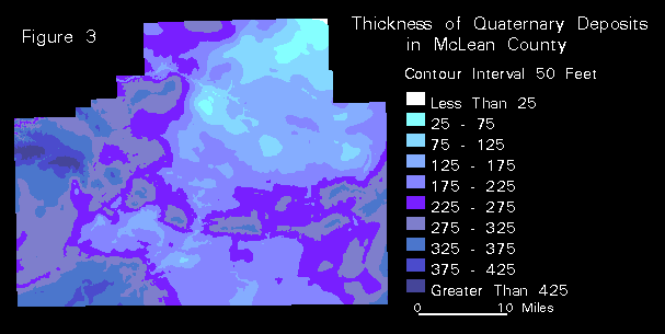
Quaternary deposits in the county include fine-grained units (clay or silt) deposited by ice or wind and coarse-grained units (sand, gravel) deposited by meltwater. The thickness of these unconsolidated deposits ranges from less than 25 feet in the northeast corner of the county to greater than 450 feet in the west central portion of the county. The thickest deposits lie within the bedrock valleys in the west and southeast portions of the county. Thick deposits in the central portion of the county indicate the presence of end moraines formed during the last glacial episode. Areas of thick fine-grained deposits, such as in the central portion of the county, are better choices for landfill sites as these materials will provide a buffer to leachate and inhibit contaminant migration and the possibility of groundwater contamination. Thick deposits within the bedrock valleys contain sand and gravel which are potential groundwater resources and poor choices for landfill sites. Areas of thin deposits, such as in the northeast corner of the county, are also poor choices for landfill sites as little material is available to provide a buffer for groundwater contamination or a daily cover for the landfill.
The three-dimensional model shows the thickness and distribution of fine- and coarse-grained units in the county. The model was based on the lithologic units described by the well drillers and indicated on the well logs. Descriptions of lithologic units were classified as fine-grained, coarse-grained, bedrock, or indeterminate and assigned a numeric property, or p value: 1 for fine-grained deposits and 3 for coarse-grained deposits. Indeterminate and bedrock units were not used in the model. An ASCII file of x, y, z and p values for the top and bottom of each unit and every three-foot interval within each unit was input into the modeling software, Geologic Modeling Program (GMP), to produce a three- dimensional grid representing the thickness and distribution of the fine- and coarse-grained Quaternary deposits. The two-dimensional grid of the ground surface topography was used to define the top surface of the three-dimensional model. The grid of the bedrock topography was used to define the bottom surface of the three-dimensional model. The model was reviewed and analyzed to ensure that correct geologic relationships were displayed. For instance, where well drillers only indicated at what depth they had encountered a sand deposit and did not indicate the fine-grained deposits surrounding the sand body, the model was extrapolating and creating a much larger sand body than the well data indicated. Modifications to the model were made by adding fine-grained units to restrict the extrapolation of the sand bodies. After modifications were made to the model, a series of sand and gravel thickness maps were created.
In order to produce sand and gravel thickness maps for McLean County from the three- dimensional model, additional gridding procedures were necessary. A three-dimensional grid representing the percentage of coarse-grained deposits (percent coarse) was created in GMP from the three-dimensional model of the fine- and coarse-grained deposits. The percent coarse grid was used to produce a two-dimensional grid representing the average percent of coarse-grained deposits (average percent) between the ground surface and the bedrock surface. The average coarse grid was multiplied by the grid of the thickness of Quaternary deposits to create a two- dimensional grid of the cumulative thickness of coarse-grained deposits. Contour lines from this grid were output and used to create a coverage of the cumulative thickness of sand and gravel deposits. The contour lines were edited to create a map that best represents the cumulative thickness of sand and gravel deposits in the county (Figure 4).
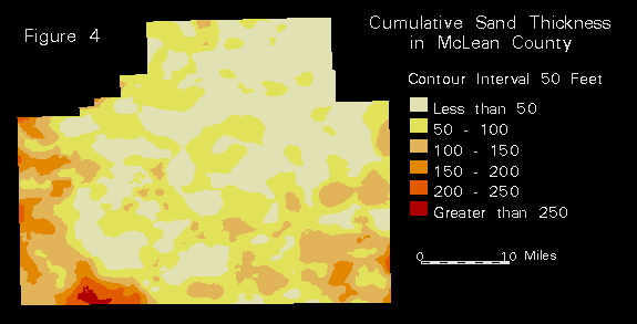
The cumulative sand and gravel thickness map shows the sum of the thicknesses of all the coarse-grained deposits in the county. Thickness of these deposits ranges from less than 25 feet to greater than 275 feet. Sands and gravels were deposited predominately as outwash from melting glacial ice that inundated the county between approximately 17,000 and 1.5 million years ago during three glacial episodes (pre-Illinois, Illinois and Wisconsin). Non-glacial sands and gravels were deposited as alluvium in stream channels. Sand and gravel outwash occurs as thin and discontinuous lenses interfaced with the Wisconsin glacial deposits and as thick units interfaced with the pre- Illinoian and Illinoian deposits which fill large bedrock valleys in the west and southeast portions of the county. Areas containing thick deposits of sand and gravel, such as the bedrock valleys in the west and southeast portions of the county, are poor choices for landfill sites whereas areas with few or thin sand and gravel deposits, such as the central portion of the county, are better choices for landfill sites.
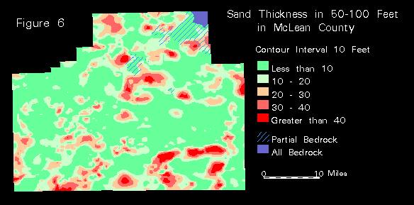
Due to the lack of data points at depth, only two 50-foot interval depth slice maps were created for McLean County. In order to create the depth slice maps showing the thickness of sand and gravel in 50-foot intervals below the ground surface, ISM was used to create two-dimensional grids representing surfaces parallel to the ground surface topography at 50 and 100 feet below the ground surface. The 50 and 100 feet parallel surface grids were compared to the bedrock topography grid. Where the bedrock intersected the parallel surface, the maximum elevation was determined, and a new grid was created. The 50 and 100 feet depth surface grids were subtracted from the surface topography grid to create thickness grids representing the thickness of Quaternary deposits within the two depth slice intervals. From the three-dimensional percent coarse grid, discussed above, a two-dimensional average percent grid representing the average percent of coarse-grained deposits in each 50-foot interval below the ground surface was created, using the surface topography and the 50 and 100 feet depth surfaces as the top and bottom constraints. The average percent grid was multiplied by the thickness grid for each depth slice interval to create a two-dimensional grid representing the thickness of coarse-grained deposits within each depth slice. Contour lines from this grid were output and used to create depth slice coverages. The contour lines were edited to create maps that best represent the thickness of sand and gravel deposits within each depth slice (Figures 5 and 6).
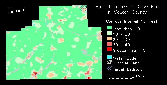
In the 0 to 50 feet depth slice (Figure 5), thickness of sand and gravel ranges from less than 10 feet to greater than 40 feet. The thickest sand and gravel deposits in this interval are outwash deposited by meltwater from glacial ice that inundated the county during the Wisconsin glaciation. Sands and gravels are also found as alluvium in stream channels. The fine-grained deposits within this slice interval are till units (clays and silts) deposited by glaciers of the Wisconsin episode. Many sand and gravel deposits found at the surface, such as alluvium in stream channels, were not recorded in the database because the units were not recorded in the well logs or wells were not drilled in those areas. Sands and gravels found at the surface that do not appear in the well data are shown by the stippled pattern overlay. This information was obtained from the 1:250,000 scale stack-unit map created for northern Illinois (Berg and Kempton, 1988). Surficial sand and gravel units from the stack-unit map were generalized to the 1:100,000 scale of the depth slice map. Bedrock is located within 50 feet of the ground surface in the northeastern corner of the county; this is shown on the map by the overlay of slanted blue lines. The topography of the bedrock surface is higher in the northeast and dips slightly to the southwest. Areas where outwash and alluvial deposits are present are poor choices for landfill sites, whereas areas of thick fine-grained deposits in this depth slice underlain by thick fine-grained deposits in the next depth slice are better choices for landfill sites.
In the 50 to 100 feet depth slice (Figure 6), thickness of sand and gravel ranges from less than 10 feet to greater than 40 feet. Sand and gravel in this interval are outwash deposited by meltwater at ice margins that have been overridden by advancing glacial ice. Fine-grained deposits within the interval are till units (clays and silts) deposited by glacial ice of the Wisconsin and Illinois episodes. Bedrock is present throughout the depth slice interval in the northeastern corner of the county; this is shown in gray on the map. Where the thickness of Quaternary deposits is less than 50 feet and bedrock is partially present is shown on the map by the overlay of slanted lines. Areas where thick outwash deposits are present in this slice are poor choices for landfill sites.
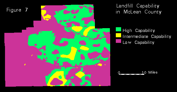
In order to construct a map ranking the relative capability of areas within McLean County for hosting a landfill, information from the maps described above was compiled and analyzed. From the map of the surface topography, polygons representing end moraines that may contain sand and gravel deposits were selected. These features trend east-west and northwest-east throughout the county. From the map of the bedrock topography, polygons outlining bedrock valleys were selected. The bedrock valleys are present in the west and southeastern portions of the county. From the map of the thickness of Quaternary deposits, a polygon outlining where deposits are less than 25 feet thick was selected in the northeast corner of the county. From the map of the cumulative thickness of sand and gravel, areas of thick sand and gravel in the west and southeast portions of the county were selected. These coarse-grained materials were deposited in the bedrock valleys. From the 0 to 50 feet depth slice, polygons representing thick outwash and alluvium deposits were selected. Thick outwash deposits from the 50 to 100 feet depth slice were also selected. Any area in the county lying within one or more of all selected polygons was ranked as low landfill capability.
The two depth slice maps were analyzed to select areas of thick fine-grained deposits in the 0 to 50 feet slice overlying thick fine-grained deposits in the 50 to 100 feet slice where well data supported the mapping. These areas were ranked as high landfill capability.
Areas not ranked as low or high capability were ranked as intermediate landfill capability. These polygons represent areas where data points were not present or were too few to provide confidence in the mapping of the thickness and extent of sand and gravel units. Also included were areas of thick fine-grained deposits present in the 0 to 50 feet depth slice overlying sand and gravel deposits in the 50 to 100 feet depth slice where the thickness of the sand and gravel deposits is uncertain. Within McLean County, approximately 404 square miles (34% of the county) were ranked as high landfill capability, 75 square miles (6%) were ranked as intermediate capability and 695 square miles (60%) were ranked as low capability (Figure 7).
The Illinois State Geological Survey has able to assist counties in landfill screening using GIS and modeling software to produce geologic maps. Maps produced for McLean County include surface topography, bedrock topography, thickness of Quaternary deposits, geologic cross sections, cumulative thickness of sand and gravel, a series of depth slices showing sand and gravel thickness in 50-foot intervals below the ground surface and a landfill capability map ranking the relative capability of areas within the county for hosting a landfill. These maps were based on an INFO database of lithologic information and a three-dimensional model showing thickness and extent of fine- and coarse-grained Quaternary deposits. Areas containing thick deposits of sand and gravel, such as the bedrock valleys in the west and southeast portions of the county, are poor choices for landfill sites and are ranked as low landfill capability. The sand and gravels are potential groundwater resources that should be avoided in order to prevent groundwater contamination. Areas of few or thin sand and gravel deposits, such as the central portion of the county, are better choices for landfill sites as the potential for groundwater contamination is less.
Geologic maps have also been produced and used for landfill screening in Champaign, Will and Lake Counties. These maps are useful not only for making landfill siting decisions but also for other land use planning decisions such as siting of water supply wells, aggregate supplies and industrial facilities based on the mapping of sand and gravel deposits.
Many individuals at the Illinois State Geological Survey have contributed to this project. The author would like to acknowledge the following for their contributions: Curtis C. Abert, Sally L. Denhart, Ardith K. Hansel, Maureen D. Kelly, Robert J. Krumm, Joan K. Junkins, Christopher S. McGarry, E. Donald McKay and Matthew H. Riggs.
Abert, Curtis C., Robert R. Pool, Matthew H. Riggs, Melisa M. McLean and E. Donald McKay, 1992. "Using ArcInfo and Interactive Surface Modeling to Produce a Bedrock Topography Map" in Proceedings of the Twelfth Annual Esri User Conference, Environmental Systems Research Institute, Redlands, CA, Volume II, pp. 83-87.
Berg, Richard C. and John P. Kempton, 1988, Stack-Unit Mapping of Geologic Materials in Illinois to a Depth of 15 Meters, Illinois State Geological Survey Circular 542, Plate 2, Scale 1:250,000.
Denhart, Sally L., 1993, "Geologic Database Design: The Foundation of a Successful Project" in Proceedings of the Thirteenth Annual Esri User's Conference, Volume I, pp. 467-475.
McLean, Melisa M., 1993, "Processing Digital Hypsography to Digital Line Graph Standards with Customized AMLs and Menus" in Proceedings of the Thirteenth Annual Esri User Conference, Volume II, pp. 191-193.
Riggs, Matthew H. and Curtis C. Abert, Melisa M. McLean, Robert R. Pool, E. Donald McKay, Robert J. Krumm, 1992, "Using USGS 1:24,000 DLG Hypsography" in Proceedings of the Twelfth Annual Esri User Conference, Vol II, pp. 391-394.
Willman, H.B., et al, 1967, Geologic Map of Illinois, Illinois State Geological Survey, Scale 1:500,000.