In the production of a contour map, a method was developed within GRID1, the cell-based geoprocessing software of ArcInfo, for degrading the detail of a high-resolution raster geographic data set (grid) to approximate that of a low-resolution grid. This preanalysis process was necessary so that a surface resulting from the subtraction of one surface from another would not produce a grid that appeared to be more detailed than the lowest resolution grid used. The high-resolution grid was derived from 7.5-minute U.S. Geological Survey Digital Elevation Model data. The low-resolution grid was derived from well data. The high-resolution grid was processed using the GRID function FOCALMEAN with a circular neighborhood option to produce a low-resolution grid.
Various radii for the FOCALMEAN function were evaluated by producing test plots of contours derived from the resultant grids. A radius equal to one-half the average distance between wells produced a grid that best represented the general character of the high-resolution grid while approximating the level of detail of the low-resolution grid.
* Use of trade, product, or firm names is for descriptive purposes only and does not imply endorsement by the U.S. Government.
As part of a study of shallow ground-water resources in the Denver,
Colorado metropolitan area, a vector geographic data set of
bedrock-surface-elevation contours was created using ArcInfo, version
6.1.1. Two input data sources were used in the creation of this
coverage:
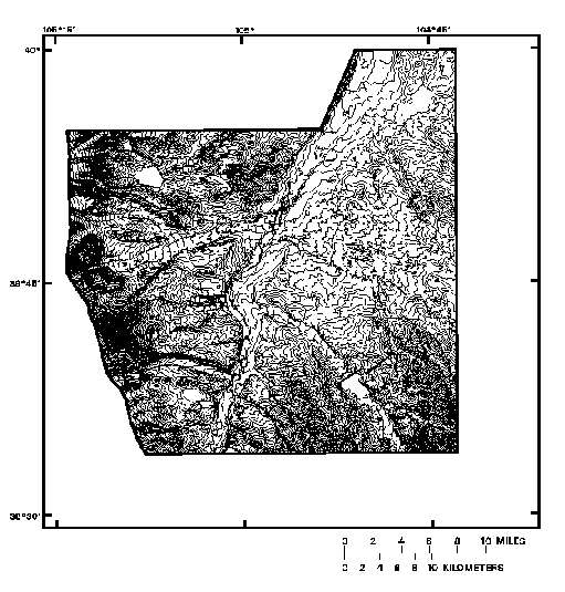
U.S. Geological Survey (USGS) 7.5-minute Digital Elevation Models
(DEM's) (figure 1) and a digitized coverage of overburden-thickness
contours that were hand-drafted at a 20-foot contour interval from well
data (figure 2). The DEM data consisted of an array of regularly spaced
elevations; the spacing between elevations was 30 meters. The well
data were derived from 6,033 wells in a 1,745-square-kilometer area.
Overburden-thickness data were a more generalized input source than the DEM data. These two sources were converted into continuous grids. The grid of overburden thickness was subtracted from the grid of land-surface elevation to create a grid of bedrock-surface elevation from which a contour coverage was generated.
However, when the bedrock-surface-elevation grid was contoured, the contours appeared misleadingly detailed (figure 3) and reflected the high level of detail in the DEM's. This paper presents a method of processing the DEM data so that a more generalized contour coverage of the bedrock-surface elevations could be created that would match the more generalized detail of the overburden-thickness data. Hord (1982), Goodchild and Ghopal (1989), and Burrough (1993) provided discussion on the general topic of data accuracy and data smoothing.
Figure 1.--Level of detail of land-surface elevation produced from USGS 7.5-minute DEM data. Contour interval is 20 feet.
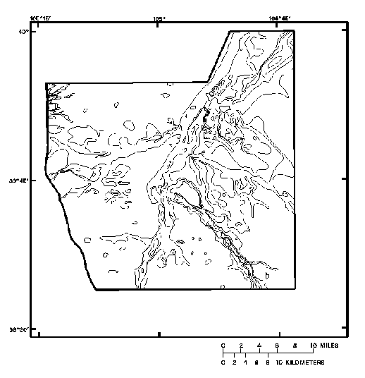
Figure 2.--Level of detail of overburden thickness hand-drafted from point data. Contour interval is 20 feet.
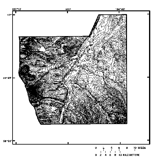
Figure 3.--Resultant bedrock-surface elevation generated from unmodified grids of land-surface elevation and overburden thickness. Contour interval is 20 feet.
One method considered for creating a more generalized contour coverage from the two data sources was the generalization of the bedrock-surface-elevation grid before using it to produce the contours. Degrading the resolution of this grid would have had the effect of degrading the resolution of both input grids. This effect was undesirable because the overburden-thickness data already were highly generalized. A method was needed for creating a generalized contour coverage that would preserve the level of detail in the overburden-thickness grid while degrading the level of detail in the grid derived from DEM data. Processing the DEM-derived grid before using it with the overburden-thickness grid resulted in a contour coverage of the bedrock-surface elevations that was more charac teristic of the level of detail of all the input data than a contour coverage produced using unaltered DEM data.
The ArcInfo GRID function FOCALMEAN was used to modify the DEM-derived grid. To approximate the level of detail in the overburden-thickness data, a circular neighborhood option was used for the FOCALMEAN function (a weighted kernel was not used in the processing but could be a valid option). The use of a circular neighborhood option ensured that the FOCALMEAN processing would not be biased in any direction. The radius length of the neighborhood was designed to reflect the number and spatial density of the wells used in generating the over burden-thickness contours. The initial radius was 540 meters, or 18 grid cell lengths, equal to the hypothetical distance between the wells if they had been evenly spaced in the study area.
The FOCALMEAN function using this neighborhood of 18 cell lengths produced a grid of land-surface elevation that was too generalized for the production of the desired contour map. Specifically, mesas appeared to be rounded hills on a contour map produced from this grid (figure 4). Several land-surface elevation grids of varying level of detail were then produced from the DEM-derived grid by experimenting with various neighborhood radii of successively shorter length in the FOCALMEAN processing. Contour plots of these grids were generated for inspection and a grid of land-surface elevation was created that preserved the general character of the land surface. Contours of the grid resulting from a FOCALMEAN neighborhood radius of 9 cell lengths (figure 5) preserved most of the topographic features while generalizing some of the finer details when the contours were at the same interval as the overburden-thickness contours.
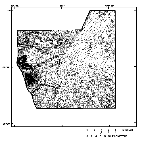
Figure 4.--Generalized land-surface elevation using a radius of 18 cell lengths. Contour interval is 20 feet.
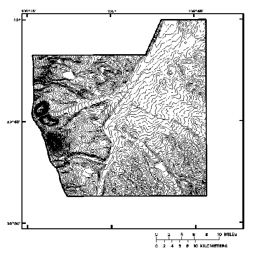
Figure 5.--Generalized land-surface elevation using a radius of 9 cell lengths. Contour interval is 20 feet.
The DEM-derived grid that was selected for use with the overburden-thickness grid was produced by the FOCALMEAN function that used a circular neighborhood with a radius equal to one-half the hypothetical distance between the wells if they had been evenly spaced in the study area. This result is consistent with the Nyquist The orem in which a discrete sampling interval equal to one-half the interval of interest produced a sampled data set that was accurate for that interval of interest (Green, 1983).
The bedrock-surface-elevation grid that resulted from the subtraction of the overburden-thickness grid from the modified land-surface-elevation grid produced a contour coverage that was characteristic of the level of detail in the overburden-thickness data. The contour coverage then was edited to remove errors caused by the inclusion of reservoirs and dams represented in the DEM data and splined to decrease the jagged appearance of the contours (figure 6).
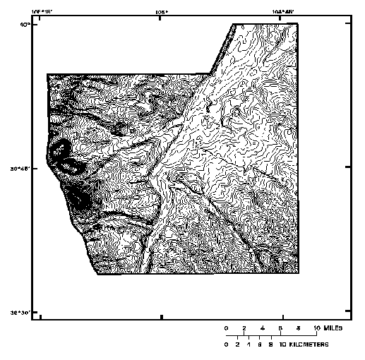
Figure 6.--Bedrock-surface elevation that resulted from the land-surface elevation generalized using a radius of 9 cell lengths and overburden thickness. Contour interval is 20 feet.
Preprocessing of the DEM-derived grid allowed comparison with the more general overburden-thickness grid in the production of the bedrock-surface-elevation grid. This method could be used as an initial guide to pro cessing variable-resolution continuous grids; each application of this method will need to be reviewed to ensure characteristic representation of the accuracy of the initial data sets.
Burrough, P. A., 1993, Principles of Geographical Information Systems for Land Resources Assessment: Oxford, Oxford University Press, 194 p.
Goodchild, Michael, and Ghopal, Sucharita, eds., 1989, The Accuracy of Spatial Databases: London, Taylor and Francis, 269 p.
Green, William B., 1983, Digital Image Processing--A Systems Approach, New York: Van Nostrand Reinhold Company Inc., 189 p.
Hord, Michael R., 1982, Digital Image Processing of Remotely Sensed Data: New York, Academic Press, 256 p.
Stephen J. Char, Hydrologist
U.S. Geological Survey, Water Resources Division, Colorado District
Box 25046, MS 415, Denver Federal Center
Denver, Colorado 80225
Telephone: (303) 236-4882, Fax: (303) 236-4912
E-mail: sjchar@usgs.gov
Jennifer B. Sieverling, Hydrologist
U.S. Geological Survey, Water Resources Division, Colorado District
Box 25046, MS 415, Denver Federal Center
Denver, Colorado 80225
Telephone: (303) 236-4882, Fax: (303) 236-4912
E-mail: jbsiever@usgs.gov