In order to illustrate the modernization process, a conceptual model has been adapted to represent the modernization process and the activities involved in the process. This model is presented as a backdrop for the modernization data about county governments currently working through the process. In this paper, we begin to validate this model and show how it relates to the successes of the Wisconsin Land Information Program.
Results are presented from an ongoing study of the rate and impact of land records modernization in Wisconsin. These results come from two surveys of Land Information Officers (LIO) distributed by the Wisconsin Land Information Board (WLIB). We present an evaluation of the WLIB, data on modernization expenditures, and general results about the status of modernization.
Our research is intended to help GIS users be more successful in establishing systems and making them perform according to their personal expectations. In order to do this, we are continuing to work towards a better understanding of the land records modernization process. This will mean expanding our use of questionnaires, studying efforts in other states, and refining the modernization model.
Struggling to meet growing land information and management problems, local governments are becoming increasingly reliant upon geographic and land information systems (GIS/LIS). However, while this process is becoming more commonplace, there is little understanding of the forces driving the process and factors inhibiting its occurrence.
The use of GIS is most often accompanied by the increased use of other complex information and land measurement technologies, like computer networks and GPS (Onsrud and Pinto 1993). Land records modernization is generally occurring in larger jurisdictions where other information technologies are also being adopted as part of integrated, enterprise-wide applications (Sprecher 1994).
In Wisconsin, the adoption and diffusion of these technologies have been found to depend significantly upon institutional factors like inter-agency communication, and moderately on other financial and personal factors, like funding and professional communication networks (Kuhlman 1994). As Judd (1995) and many others point out, not only do organizational factors affect the adoption but they also influence the ultimate success or failure of the technologies.
In an attempt to better understand the different factors of modernization, the Land Information and Computer Graphics Facility (LICGF) initiated a series of surveys to measure the status of land records modernization in Wisconsin (Kuhlman 1993). These surveys have already been used as an annual reporting mechanism for participating counties in the Wisconsin Land Information Program (WLIP) for 1992 and 1993, with second year including expanded status and new evaluation questions.
Various adoption and diffusion ideas and data about the actual nature and extent of GIS/LIS development (Onsrud and Pinto 1991, 1993; Masser and Campbell 1994; Kuhlman 1994) helped generate a general GIS/LIS-based land records modernization model that characterizes the status of system development in local governments. This theoretical model characterizes the modernization process as a continuum with adopters at different points in the process. The continuum divides into six stages: no modernization; system initiation; database development; recordkeeping; analysis; and management/democratization. This six-stage model is an expansion and refinement of a four-stage model proposed by Crain and MacDonald (1984).
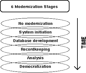
Figure 1 -- The six stages of modernization as represented in the theoretical modernization model.
Each stage is defined by identifiable, measurable, and independent factors that correspond to activities occurring during that stage. As suggested in Figure 1, the boundaries between modernization stages are not rigid but overlapping. There is a movement from the first stage to last, with organizations not necessarily being limited to the activities associated with one stage or adjacent stages. Rather, development consists of the addition of more sophisticated activities and uses as an organization moves from one stage to another.
The first stage -- no modernization activity -- is characterized by both the absence of technology and the lack of planning for or intent to use the technologies. System initiation, the second stage, is the first active phase of development consisting of needs assessment, system design, budgeting allocations, and so forth. In the database development stage, data are collected and organized. In the recordkeeping stage, those data are used for response to routine queries and retrieval. When data are used for spatial analysis and complex queries, the analysis stage is reached. Finally, when data are manipulated to guide public policy decision-making by public officials and citizens, the management or democratization stage has been reached.
It is our hypothesis that this conceptual model, as briefly described here, is an appropriate and accurate representation of the modernization process for local governments. For this paper, it is our intention to provide a basis for this model with recent survey results from Wisconsin. In addition, general results of the survey are reported to show the overall status of modernization in Wisconsin.
The Wisconsin Land Information Program (WLIP), a relatively new creation, is playing a crucial role in the modernization of land records in Wisconsin. As a result of years of effort Wisconsin Acts 31 and 339, which created the Wisconsin Land Information Board (WLIB) and the WLIP, were enacted in 1989. The legislation created the WLIP to provide counties ongoing support in their efforts towards modernization. These Acts also included an arrangement for funding both the modernization efforts of counties and the WLIP without using money from the state's general fund.
All 72 Wisconsin counties have now submitted county-wide modernization plans and are participating in the WLIP. For each of these counties this means support in a variety of forms including political, technical, and financial. Generally considered the most important form of support, the financial support is produced by a land recordation. Two-thirds of the fee are retained by the county while the remainder is used for administrative costs and mostly returned to the counties in the form of grants-in-aid.
For several years, the program operated under the threat of a "sunset clause" which would end the program in 1997. However, this sunset clause was removed by the Wisconsin legislature during 1994, allowing the program to continue indefinitely. However, recent changes in the political composition of the state legislature has caused the "sunset clause" to be renewed demanding justification of the program in 1996.
In cooperation with the Wisconsin Land Information Board (WLIB), a survey (Q1) was designed to satisfy both practical and research questions about the status of modernization in Wisconsin local governments in 1993. Used as the annual reporting mechanism for counties participating in the WLIP, the survey allows the WLIB to monitor the expenditure of grants-in-aid and retained fees while the LICGF was able to use the questionnaire to better understand the development of GIS. The following year, the status portions of the survey were expanded and a second section (Q3) was added to evaluate the effectiveness of the WLIP and WLIB.
Whenever possible, guidelines for survey preparation and distribution as described by Dillman (1978) and Babbie (1990) have been followed. However, because of the unique use of the annual reporting mechanism as a survey, response rates were not the driving force behind decisions as much as completeness, clarity, and accuracy of data.
The surveys are sent to the land information officer (LIO) of each county. In Wisconsin, the LIOs are the individual or team identified by each county as its official responsible for the execution of a state-approved land records modernization plan. In most counties, this individual also serves in some other capacity, often a register of deeds, surveyor, or real property lister. Because of the variety of material requested in the survey, the LIOs often request that specialists from throughout their county complete different portions of the survey, usually making it a survey of the entire county government rather than an individual.
Expanding on statutory language directing counties through their modernization efforts, Q1 is largely organized by "Foundational Element." The 13 foundational elements used are base mapping, geographic reference framework, parcels, wetlands, soils, zoning, hydrography, transportation, utilities, administrative units, institutional arrangements, public access, and communication, education, and training. Parallel information is collected about the value of expenditures, source of funding, and type and quality of data for each foundational element.
As one of the primary driving forces behind modernization in Wisconsin, the WLIP has provided important assistance for local governments. However, in order to improve the program, LIOs were asked to evaluate the support provided by the WLIP. While much of Q3 addresses specific issues in Wisconsin, there is some valuable information produced for efforts occurring elsewhere.
As a general measure of the effectiveness, respondents were asked about the role that the WLIP had played in initiating their counties' efforts. Every county indicated that the program had played some role in initiating their county's modernization efforts (Figure 2). All but seven counties said that the WLIP had been "somewhat" or "very much" involved in this initiation of the process.
In addition to the question concerning initiation, a parallel question inquired about the programs role in accelerating the counties' programs. Although four counties responded that the WLIP's role had been "not at all" and another four reported that it had been "very little," the vast majority of counties still indicated that the WLIP had played a significant role in the accelerating of their program.
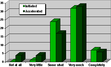
Figure 2 -- Response to the question, "What role has the WLIP played in initiating/accelerating land records modernization in your county?" (1993 Survey)
These overall indicators of the success of the WLIP illustrate the importance that county LIOs place upon the program. This evidence seems to provide evidence that a strong state-wide program can play an important role in both initiating and accelerating land records modernization.
Respondents were presented a list of state programs and asked about the importance of having them coordinated with the WLIB's activities. The responses were made on a five step scale from "not important" to "very important" which could then be reduced to a simple score. Among the activities that scored the highest were the following: "conducting wetlands mapping activities," "vocational training," "education and outreach," "providing technical assistance," "sharing digital survey data," and "collecting, maintaining, and disseminating information regarding innovation in cartographic techniques and mapping procedures." These responses repeatedly reflect a desire for training and education about GIS/LIS and related issues.
The evaluation also included measures about 15 specific WLIB efforts. An abbreviated list of 5 activities, which captures the two extremes, is shown in Figure 3. "Coordinating state agency plans" and "developing standards" were both shown as problem areas for the WLIB. As in the previous question, the need for an increase in the quantity and quality of technical assistance is reflected in a low rating. In contrast, the Board was rated as "doing well" at providing education and training by over half of the counties.
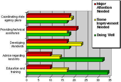
Figure 3 -- WLIB effectiveness evaluated for selected activities from a list of 15 Board efforts (1993 survey)
At the time of the first annual survey, 71 of Wisconsin's 72 counties participated in the WLIP. Of the participating counties, all but one responded, providing a 98% response rate. In the second year, 1993, all 72 counties had chosen to participate in the program. At the time this paper was written, 68 counties had responded, providing a 94% response rate.
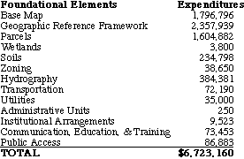
Table 1 -- 1993 expenditures on foundational element, excluding salary, by funding source (1993 survey)

Respondents reported spending a total of over $6,700,000 dollars on foundational elements, excluding staff salaries (Table 1). Of that total, 43% came from the WLIP retained fees or grants-in-aid. The WLIP sources of funding, both grants and fees, are derived from a recordation fee on title transfers. An even larger portion, 45%, was contributed by counties from levies or taxes. The next largest source of funding was utilities, contributing about 7% of the spending.
Table 2 -- Expenditures by foundational element, excluding salary (1993 survey)
The foundational element expenditures, excluding salary, are distributed unevenly (Table 2). The geographic reference framework represents 35% of the funds (Figure 4). Base mapping and parcels mapping represented another 27% and 24% respectively. Thus, approximately 86% of the funding spent on foundational elements was devoted to elementary foundational elements.
The only natural resource elements that received notable funding were hydrography (6%) and soils (3.5%). Considering that salary is excluded, communication, education, and training receives a sizable sum at over 1%. It is that investment in education that shows organizations are making long-term commitments to the modernization process. In response to requests from participating counties, longitudinal consistency was sacrificed to allow easier response to the financial questions. Therefore, 1992 expenditure data includes salary and 1993 data do not. While this makes comparisons difficult, we have isolated each foundational element as a percentage of each year's total. The comparisons of these data do not necessarily show increases or decreases in amounts spent, but do show categorical shifts in spending.
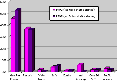
Figure 4 -- Spending on individual foundational elements in 1992 and 1993 as percentages of that year's total foundational element expenditures (1992 and 1993 surveys)
One indicator of modernization stages is the number of foundational elements being addressed by a county. As an organization modernizes, the number of foundational elements will likely increase even though the expenditures on some elements may be reduced to a minimum cost of maintenance. At first glance the expenditures data (Figure 5) may seem reassuring because five counties reported expenditures on at least six foundational elements. However, it should also be noted that over half of the counties were addressing fewer than two elements. Furthermore, the two counties addressing the most categories, eight, still addressed only half of the 16 foundational elements listed in Table 2.
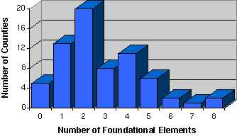
Figure 5 -- Number of foundational elements for which counties reported expenditures (1993 survey)
An overall measure of the continuing modernization is the type of GIS/LIS software being used (Figure 6). While we want to avoid commenting on individual applications, some valuable insights are available through these data. A very reassuring sign is that in 1992 the most popular GIS/LIS software was "none" and in 1993 it was a specific package. An indicator of the general growth that is occurring is the large increase in number from 1992 to 1993 of most software products. The sudden jump of ArcView (a new product in 1993) past ArcInfo shows the importance of making data accessible to managers and decision-makers who are unable to use more complex software packages. Of some concern is the emphasis placed on drafting applications, which permit spatial analysis, instead of GIS packages, which do.
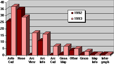
Figure 6 -- Number of Wisconsin counties using various GIS software packages (1992 and 1993 surveys)
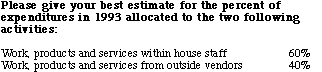
As a measure of counties' ability to address changing issues of technology, the means of production of work, products, and services was solicited (Table 3). As a probable sign that counties have progressed towards independence, respondents most recently indicated that 60% of their expenditures were allocated to in-house activities as opposed to 40% spent on outside vendors.
Table 3 -- Division of expenditures between in-house staff and outside vendors (1993 survey)
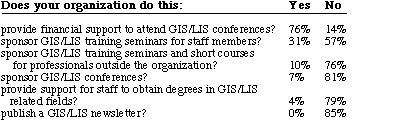
As an indication of a commitment to modernization, a number of counties are supporting their staff's needs for education and training (Table 4). The primary education activity that the respondents identified was support for attendance of conferences. The second most common activity, in-house training seminars, received less than half as many responses, suggesting that while commitments to development have begun to be made, needs are not yet being fully met by counties.
Table 4 -- Level of activity in various categories of communication, education and training (1993 survey)
Another sign of long-term commitment is the changing composition of staff in Land Information Offices. A majority of counties, 45, responded that their Land Information Office consisted of several staff members; 18 counties indicated that their office consisted of an individual only. In addition, 13 counties responded that the office included County Board members (numbers add up to over 72 because some selected more than one choice).
While many of the responses mentioned so far show the rapid progress of modernization, some indicators are reminders that work remains to be done. Public access is a foundational element for which the lack of development is noticeable. Only one county responded that it had an organized public access program. While over half of the counties, 37, responded that they had public access terminals, all 37 had tabular systems that were often part of an existing program through the treasurer's and register of deeds' offices. Only four of those counties had public access terminals with graphic capabilities.
Table 5 -- Land Information Officers by number of individuals and cumulative years of experience in occupational fields. Number of LIOs adds up to more than 72 because some respondents choose multiple occupations. (1993 survey)
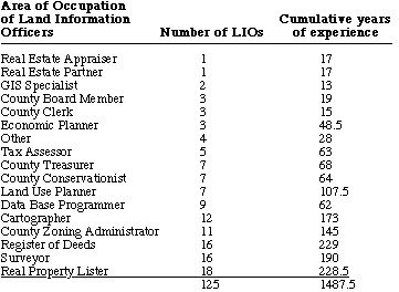
When asked about experience, LIOs individually were found to have less experience in GIS than in other fields (Table 5). The fields that dominate the positions are Real Property Listers, Registers of Deeds, Surveyors, Cartographers, and County Zoning Administrators with each representing the background of more than 10 LIOs. While many of these are LIOs with valuable skills and knowledge, it illustrates the complexities involved in the transition from training in a traditional field important to local government to one using a fully modernized system. Few people are yet available with a training or background specific to the GIS/LIS needs of these counties.
Modernization is clearly occurring throughout Wisconsin local governments. The stages of development seem commensurate with the length of time the WLIP has been in place. The software used and dollar amounts spent show there is a greater focus on creating digital mapping systems than on activities that utilize products of GIS/LIS for complex spatial analysis. If the stage theory is correct, the future will move toward integrated systems for analysis and decision support. To meet this goal, emphasis needs to shift from the very strong focus on mapping and frameworks to a more reasonable distribution of funding and effort.
The theoretical model provides a framework illustrating some problems in developing mapping without ties to information. A quick study of the model reveals that it is difficult to enjoy benefits from modernization during the first three stages. Without the modernized land records, however, an organization can never be very involved in the last three stages of modernization, which is when many benefits will accrue. The development of mapping without balanced attention towards information will always severely limit organization in the benefits they can receive from modernization.
Before modernization progresses significantly, other changes are needed. Specialization in GIS and other related fields should be better represented among those who are actually responsible for the modernization. Land records modernization should be the object of increasing education and training for technicians, decision-makers, and the general public. It is the education of the public, in addition to better access to data and information, that is necessary for the final stage of modernization -- democratization -- to be achieved.
While the survey results produced so far are not complete validation of the model, they do provide a backdrop for its further consideration. The data describe situations contributing to an understanding of the model and confirming some of its basic premises. The data do not contradict the model, thus adding to its validity.
It is an ultimate goal of this research to establish and improve the validity of the theoretical model. A key objective in this task would be further establishing the stages of modernization. A determination of the relative importance of these factors over time in the process of modernization represents the second major objective in the development of this model.
In addition to the two surveys described so far, an additional survey, Q2, has been developed specifically to address the issues in the theoretical model. Q2 provides measures of the indicators and factors of the process from both government employees as well as private practitioners. We are in the process of distributing Q2 to land information professionals throughout Wisconsin.
As a final test of the modernization model, similar surveys are being used outside Wisconsin. The distribution of Q1 and Q2 to Ohio counties should provide a final verification of the model in concept and specifics. It may be possible to use additional states including Arkansas, Georgia, and North Dakota as a part of the study.
The WLIB plans to continue the use of Q1 and Q3 as its annual reporting mechanism. The results from these are becoming more valuable as a way of defending the program against new threats of elimination as a response to budgetary crises.
Establishment of the GIS/LIS modernization model would directly benefit local governments, as well as other organizations involved in the modernization process, by providing direction through the process. The model also provides academic benefits -- development of a common language for description of modernization and common conceptual thinking about modernization process. Finally, this improved understanding of the process will aid future efforts at identification of the benefits of the modernization process.
As an on-going project this research has relied on many people. However, it is possible to identify a few who have been responsible for the most recent stages of the research. William Holland and Abdul Hadi Harmans Shah both helped produce much of this article for the URISA '95 Proceedings. The LICGF, especially Kristine Kuhlman, has been central to the development and analysis of the surveys and theories presented in this research. The Wisconsin Land Information Board, especially Georgia Hopf, has provided valuable organizational and moral support. Funding has come from the National Center for Geographic Information and Analysis and the National Center for Resource Innovations.
Babbie, Earl, Survey Research Methods, Belmont, California: Wadworth Publishing, 1990.
Crain, I. K. and C. L. MacDonald, "From Land Inventory to Land Management," Cartographica, 21 (1994) 40-46.
Dillman, Don, Mail and Telephone Surveys: The Total Design Method, New York: John Wiley, 1978.
Judd, Damon, "Thoughts on Implementing a GIS," Earth Observation Magazine (March 1995) 50-51.
Kuhlman, Kristine, "Building a Framework to Characterize Land Records Modernization," In Urban and Regional Information Systems Association Proceedings, 146-151, 1993.
Kuhlman, Kristine, Measuring the Influences on Land Records Modernization in Wisconsin Counties, unpublished M.S. Thesis, University of Wisconsin-Madison, 1994.
Masser, Ian, and Harlan J. Onsrud (Eds.), Diffusion and Use of Geographic Information Systems, Kluwer: Dodrecht, 1993.
Masser, Ian and Heather Campbell, "Monitoring the Take-Up of GIS in British Local Government," In Urban and Regional Information Systems Association Proceedings, 745-754, 1994.
Obermeyer, Nancy J., "Spatial Conflicts in the Information Age," In Urban and Regional Information Systems Association Proceedings, 269-282, 1994.
Obermeyer, Nancy, and Jeffrey K. Pinto, Managing Geographic Information Systems, New York: Guilford Press, 1994.
Onsrud, H. J., and J. K. Pinto, "Evaluating Correlates of GIS Adoption Success and the Decision Process of GIS Acquisition," URISA Journal 5 (1993): 1, 18-39.
Sprecher, Milford H., "ICMA Survey Dissects Local Government IT Use," URISA Journal 6 (1994) 2, 92-94.
Ventura, S. J., P. Kishor, B. J. Niemann, K. Kuhlman, E. Epstein, and W. Holland, "Laws That Drive Change: GIS/LIS Development by Local Governments," GIS/LIS '93 Proceedings, vol. 2, 681-690, 1993.