In this paper we present ArcInfo based application for assessment of the road and traffic impacts to the environment. The estimation of the environmental vulnerability is based on the information about fauna, flora, soil, water, air, climate, landscape, natural and cultural environment, urban areas, etc. and the importance of different phenomena. The importance is established by weighting inside and between the layers. The vulnerability of individual layers as well of the joint layer can be presented in different colour shades and can be used as one of the graphics bases for the optimal room layout selection. Joint layer can be converted into the grid and the least impact corridor between origin and destination can be calculated. This corridor can be used as another source of information for the optimal room layout selection. Several alignment alternatives can be overlaid above the joint environment layer and the cumulative impact can be assessed. Strip maps show the impacts on each alignment section.
The Environmental Impact Assessment is a procedure, where we identify, describe and assess the direct and indirect effects of the project on the following factors: human beings, fauna, flora, soil, water, air, climate, landscape, material assets, cultural heritage, the inter-action between the factors. Some impacts can be measured by known procedures (agriculture, forestry, water, noise, emissions, vibrations) because they have bounds determined by the statute and constitution. Other impacts are evaluated on the basis of simulation models (scoping). Here we must take into account the subjectivity of certain expertise. Therefore it is necessary to assure the transparency of the procedure. While impact assessment is connected with extensive environment data collection and analysis, GIS technology represents the right tool for this task.
The goal of the Environmental Impact Assessment is to find the least impact corridor and to select the best alignment alternative between two places. In this early stage, analyst should define the study area and identify environment layers that should be considered in the analysis. Considering the previous experiences we suggest 400 m wide corridor around straight line between the origin and destination.
After we determine the study area (considering suggestions in conclusions), we have to collect and enter information about the environment. As always this task represents the most time (and money) consuming part of the project. But in these days digital information in suitable format is more and more available also in Slovenia. The whole area of the country is covered by scanned images from scales 1:250,000 up to 1:5,000. The information is separated into topography, contour lines, hidrography layer and annotations what makes (semi)automatic vectorisation much easier. Several information layers have already been vectorised. Digital orthophoto can also be used as a background information.
Different experts prepare the data bases on fauna, flora soil, water, climate, etc. When the data is entered, the estimation of area vulnerability is made, taking in consideration available information on the particular phenomena of the area. The vulnerability of individual environmental factor which is prepared on his own layer is shown in different colour shades.
Usually there are four different stages used for this estimation:
1 - no impact
2 - small impact
3 - large impact
4 - unacceptable impact
For example, grades from 1 to 4 are assigned to different soil types, according to perception of the expert.
After then, all these layers are joined into one layer which is later used in the analysis. Total vulnerability of each polygon is calculated as a sum of grade multiplied by layer weight. Layer weights are represented as percents. For example, hydrology represents 40% of the total, while soils, agriculture and forestry 20% each. That means that water supplies are twice as much important as soils in this area. Of course, determination of this relative importance of each layer is very complicated task. It requires team work of different experts and probably application of some special methods developed for so called "soft systems".
The optimal workflow would be first to determine the best corridor and after then to develop some possible layouts through this corridor. The joint polygon layer is converted to grid and with use of costdistance and corridor functions one can develop the corridor where all the layouts should go through. This corridor can be plotted and used as a base map for design of road alignments thus designer can avoid major conflicts with environment already at the beginning.
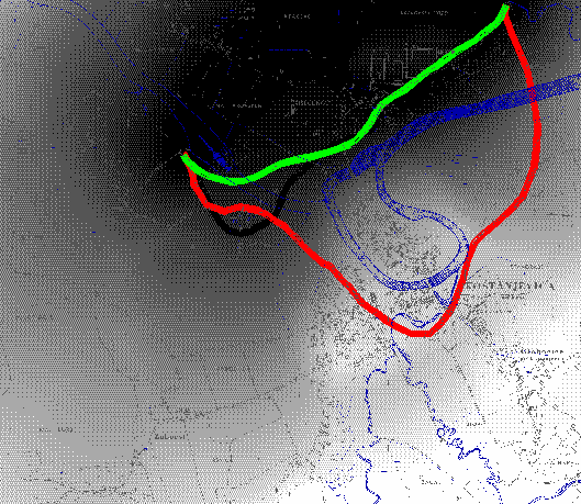
Figure 1: Minimum impact corridor and alignment alternatives
Specialised roadway design packages can be used for alignment development. Most of them support data interchange with GIS packages. Digital terrain model, buildings, rivers, etc. can be imported to the design package, and road alignments with all cut and fills exported to the GIS database.
When the different road alternatives are set, the estimation can be done with overlaying the layers of area vulnerability and the road centrelines. In this way we can establish for each arc separate and total vulnerability of the underlying polygon. This vulnerability is multiplied by the length of the arc and cumulative value for each alternative is calculated. The results can be inspected as a tabular report and represented as a histogram. Stripmap of the vulnerability is also displayed.
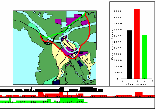
Figure 2: Cumulative impact of each alternative
The application is implemented as a set of AMLs and MENUs with extensive use of ArcTools. It was developed and tested under ArcInfo 6.1.1 on HP-UX.
Presented application enables assessment of road and traffic impacts to the environment. Road planners and designers can use it for development of least impact corridor and selection of the most suitable alignment alternative. The problem of ponders was touched and possible solution was suggested. When considered as if-then analysis tool it can be of great help to decision makers. The application was tested on several projects in Slovenia and the showed satisfactory results.
As traffic impacts are not limited to the area of physical change (road body) the application should be enhanced to take into account different zones of road environment impact: zone of direct physical modification (pavement), zone of direct modification (total land requirement-right of way), zone of indirect impact (area up to 100 meters from the road) and zone of visual contact (approximately 450 meters from the road).
National Environmental Policy Act of 1969, USA
Council Directive of 27 june 1985 on the assessment of the effects of certain public and private projects on the environment (85/337/EEC) Official Journal of the European Communities No. L 175/49
The role of Environmental Impact Assessment in the Decisionmaking Process
Merkblatt zur Umweltvertraeglichkeitsstudie in der Strassenplanung (MUVS), Entwurf, FGSV, Koeln 1990
Environmental Assessment - A Guide to the Procedures, London HMSO, Department of the Environment, Welsh Office
Glenwood Canyon 1-70, Environmental Concern, Colorado Department of Highways
Transportation Facilities through Difficult Terrain, Colorado Department of Transportation
Environmental Policy Statement, The Federal Highway Administration
Environmental Impact Statement, Guidelines and Format, Illinois Department of Transportation