This paper and application spotlight demonstration of the package will describe the requirements, design, and technical components of the CGDB User Support Package, as well as the development and maintenance processes, and ideas for future enhancements.
BACKGROUND


The City of Seattle Engineering Dept. has responsibility for stewardship

of City's Central Geographic Database (CGDB). The CGDB consists

of 5 primary layers, each containing multiple coverages and associated

files.  The CGDB provides the spatial foundation for the various

thematic GIS layers which are maintained by City departments.
- The Common Land Data Base is the City's 1/4 section base map which includes detailed survey data and the underlying legal divisions of land.
- The Parcel Layer delineates ownership boundaries and is linked to the King County Department of Assessments property records.
- The Street Network Database contains street centerlines which are linked to potential address ranges.
- The newly created Topography layer delineates elevation at 2 foot intervals.
- Digital orthophotos were taken for the entire City in 1993. The image library will be complete by mid 1995.
REQUIREMENTS
The name "User Support Package" provides an overview of its main purpose: to support the users of the CGDB. In the requirements phase of the design, it was our task to define the details of user needs and expectations for the package. In the beginning, it appeared that expectations were varied and difficult to quantify. After a series of user interviews, common definitions, expectations and needs began to emerge and the User Support Package began to take shape. We created a listing of the purpose and definition of the package in order to obtain concensus on why the package was being created, who it would serve, when it would be used, and what it would contain.Why
- Technical GIS users had problems with the CGDB, including difficulty in finding the information they needed, knowing the appropriate uses for certain data elements, and in duplicating efforts with data and programs.
- The CGDB User Support Package was created to provide an information source about the CGDB elements for use by the technical GIS users in the City of Seattle and to create a sharing mechanism for data, tools and applications.
- The CGDB User support package was designed to act as a prototype and design framework a for a future support package that could include all City GIS elements. Long term development by department would be incremental.
- It provides a base to develop future user support for novice GIS users in the City.
- A side benefit of this project is the opportunity it created to organize existing data and programs and to standardize future development by technical GIS users in a shared system environment.
Who
- The technical users of the GIS are the direct day-to-day users of the GIS system and its data layers. These are people from any department that create map products, develop applications, conduct analysis of the data.
- The technical users are similar in their level of expertise in GIS, but their knowledge of the different components of the CGDB will vary widely.
- The technical user is an informed user looking for detailed information about the CGDB, such as the overall history and content of data layers, where they are located, and key data values associated with data (coverages and files, listing of key items and values, libraries, relates).
- It is important that the CGDB User Support Package focus on the technical users and the functions they require.
When
The CGDB User Support Package will be used- When a new application is being developed.
- When new map products are being created.
- When ad hoc analysis is being conducted.
- As a training tool for new users on the system.
- As a guideline and standard for storage and documentation when new layers are being created.
What
The CGDB User Support Package contains documentation of the CGDB. This includes:- A data dictionary: information about the coverages, attributes, expansion tables, lookup tables, symbol and line tables, relate environments, libraries, standard tools etc. that make up the CGDB.
- Metadata: information about data history and sources, contact person, suggested uses, etc.
- General descriptions of the CGDB for new users of the system.
- A series of existing tools and shell AML's that will useful to all technical users. Some of these might include address matching, standard City-wide maps, or mailing label generation. Standard reports, such as data transmittals, coverage lists, data by departments etc.
- A fully maintained bulletin board that provides information on recent changes to the database, technical tips, meeting schedules, maintenance update information.
DESIGN
Once the requirements for the User Support Package had been agreed upon, a technical design was drafted. There were several technical design criteria that arose in the interviews. First, the package needed to be as simple as possible, both in content and useability. Second, it had to be accessible from every user workstation in the City and not require any new software purchases. With these requirements, it was clear that the package would need to be programmed directly in ArcInfo, using INFO as the database. The design was created in a simple format that could easily be migrated to another database in the future. Access to the package is via Arcplot menus. Figure One shows the first menu of the system, with each of the required elements.Data Dictionary
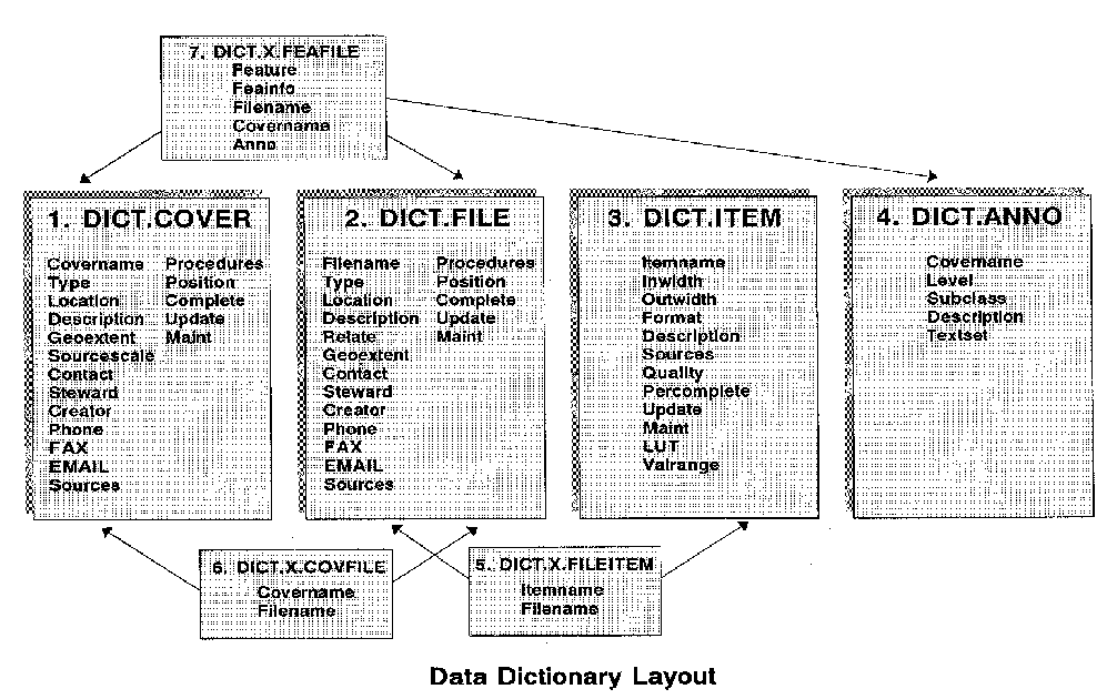
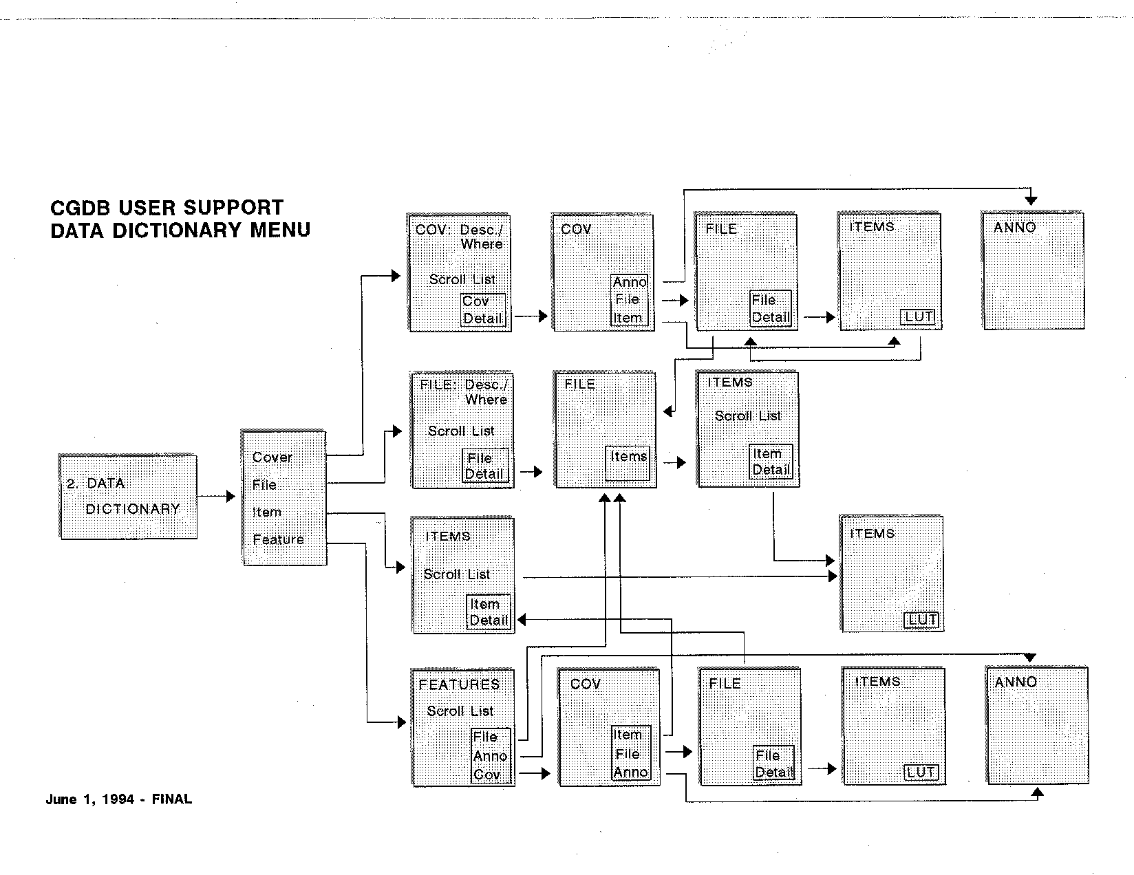
The foundation of the User Support Package is the data dictionary. With the importance of relationships among the data elements, a relational database structure was used, with cross reference tables among the elements. A table was created for coverages, files, items, and annotation. The layout of these tables and their relationships is seen in Figure Two. The majority of required items were easy to define. Meta-data items were added using the Federal Spatial Data Transfer Standard as a guideline. Finally, the data dictionary access menu was designed. The flow was as simple as possible, beginning with a choice of each of four main elements: coverage, file, item, and feature. Features were created to accommodate those elements that were not truly a coverage but were commonly referenced, such as blocks or streets. Annotation is accessible via the coverage menu. Figure Three shows the design of the data dictionary access menu. While the flow is concentrated in the direction of the four main elements, it is also easy to move among those elements in the menu. For example, details about items or files can be reached from the coverage menu track. The description field in the data dictionary files allows the user to find items, coverages, files or features using key words when the true name is not known.Tools
The front end for the tools menu has been created. A scrolling list format is used so that tools can be added as required.Standard Reports
This was also designed so that reports can be added as necessary. The first set of reports is a series of transmittal reports to accompany data requests.Bulletin Board
The bulletin board is currently just a front end. It is going to be added in 1995.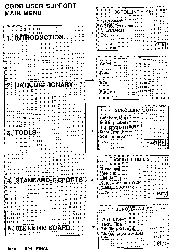
IMPLEMENTATION
Once priorities and a schedule were agreed to, it was decided that a small team (2-3 people) would be put in charge of implementing the User Support Package. Ultimately it will be the responsibility of a "User Support Package Steward" to maintain the data and ensure its integrity over the long term. A primary goal of the implementation process is to ensure consistency and accuracy within all components of the User Support Package. In part, this would be acheived through well thought-out standards and conventions. Additionally, automated methods to populate the data dictionary and other components of the documentation would be used as much as possible to minimize data entry errors. The implemenation process has been incremental, beginning with the CGDB Data Dictionary. Each component of the Package will be developed separately and added in as it becomes functional. This approach allowed us to begin with the fun part first - a menu-driven user interface. The Arcplot-based menu interface, was written and shown to existing and potential users of CGDB user documentation. With a few minor enhancements, it has been accepted as the template to which each component will be attached.Data Dictionary
Since the Data Dictionary is the primary component, emphasis was immediately placed on finalizing its design and getting the data entry underway. Several steps were undertaken: Several meetings were held with project managers to look closely at the documentation and meta-data requirements of the users. The CGDB Maintenance and Operations Group had several years of front-line user support experience to draw on in the process of finalizing the contents of the data dictionary. Although the Federal Standards for metadata were used as a guideline, it became clear that the City had specific needs not easily accomodated through that design and that several additions to the initial design would be required.- A data entry interface was designed and written using AML. The interface was intended to support a non-technical ArcInfo user whose primary task would be compiling the source data and getting it into INFO. It also included automated routines to perform standard entries.
- An intern was hired to test the interface and data dictionary design with a small subset of data. This proved to be a valuable step, as we were able to pinpoint and deal with a number of exceptions and data anomalies which had not been previously thoought of. The process also gave the User Support Package team an opportunity to refine a list of standard definitions and dictionary entries.
- Data compilation and data entry began with the CGDB Parcel Layer. Data is initially written to a temporary file before a series of automated and manual quality checks are performed. Error files are created to assist the data entry technician in making corrections. After corrections are verified, the final contents are copied to the master data dictionary files and made available across the network to City users.
- The data entry interface has been modified to create a maintenance
interface. Maintenance will be performed on a regular schedule
beginning immediately when a layer is written to the master files.
Next Steps
The completion and enhancement of the User Support Package will be an on-going respsonsibility of the Engineering Department's CGDB Maintenance and Operations group.- Establish mechanisms to trigger updates when necessary. A short-term task will be to modify existing CGDB maintenance and library check-in routines to automatically update the User Support Package files. (ex: date of last update written out each time a coverage is updated)
- Design and implement standard reports (ex: standard transmittals for data transfer, data layer descriptions, list of contacts by Department) This work is already underway but will be on-going as new needs are identified.
- Provide access via User Support Package functionality to existing and planned automated tools. This will include data translation routines, standard query applications, and a standard map-maker tool known as "map-o-matic".
Kirsty Burt
KBGIS
9950 Lake Washington Blvd. NE, Suite #3
Bellevue, WA 98004
Telephone: (206)454-6756
Fax: (206)454-6287
E-mail: kirstyb@netcom.com
Vicki Evans
Project Manager
City of Seattle
400 6th Ave.,
Rm. 510
Seattle, WA 98104
Telephone: (206)684-8857
Fax: (206)684-8914