Emergency preparedness of a state or locality is measured in terms of its ability to deploy emergency response units in a timely and effective manner should an event (accident or incident) occur. Response time is a primary consideration in deploying emergency response units. This paper illustrates GIS-based allocation of response units along a transportation route using travel time impedance. A case study is presented showing potential routes for hazardous material shipment in Clark County, Nevada.
The analyses were conducted using the Geographic Information System (GIS) ArcInfo software on a Sun MP/690 hardware platform. Point, line and polygon coverages created in the ArcInfo environment helped represent the emergency response units, transportation network, and population impact area and emergency response unit service area, respectively. The analyses include extensive usage of the ArcInfo commands such as BUFFER, UNION, network analysis ALLOCATION, and AML commands.
The Department of Energy is currently studying the feasibility of siting a geologic repository at Yucca Mountain, Nevada to store high level waste (HLW) and spent nuclear fuel (SNF). The possibility of a geologic repository in Nevada brings about site specific and transportation related issues. In the transportation aspect, selection of a safe route is one of the primary concerns.
One factor affecting the selection of route for hazardous materials transportation is emergency response preparedness. The choice of the transport route will determine the extent of potential impacts of hazardous materials shipments to population, the environment and the infrastructure. The ability of a state, county or municipality to mitigate the consequences of hazardous material incidents or accidents involving the release of hazardous or radioactive materials along the transport route largely depends on emergency preparedness. Preparedness can be measured in terms of proximity of response units to an accident, availability of equipment, availability of personnel, and personnel training.
A Unix-based GIS program, ArcInfo, run on a Sun MP/690 platform is used to evaluate emergency preparedness along potential hazardous material routes in Clark County, Nevada. In this paper, emergency preparedness is measured in terms of response time. Response time is defined as the travel time from the location of the response unit to the scene of an event. It assumes that all response units have equal capability. The fire stations are assumed to be the response units since they are usually the first responders called to the site of an accident. Response times of 5, 10 and 45 minutes are used to determine route segments requiring emergency response units.
The analysis involves: i) identification of the emergency response units and their locations with respect to the existing highway network in the County; ii) determination of service zones for each response unit for various ranges of response times; and iii) identification of zones with overlapping response units and critical zones with no proximate response units.
Clark County is one of the seventeen counties in Nevada. This county encompasses the Las Vegas Valley and the City of Las Vegas, considered to be the entertainment capital of the world. Las Vegas is located 90 miles southeast of Yucca Mountain. Shipment of hazardous materials to the proposed repository at Yucca Mountain could have major impacts on the affected counties such as Clark County.
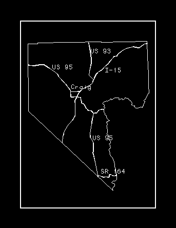
Figure 1 shows the highway network of the county. The major roads which are likely to be considered for hazardous materials routing is shown in Figure 2. These include I-15, US-95, US-93, and Craig Road.

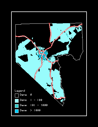
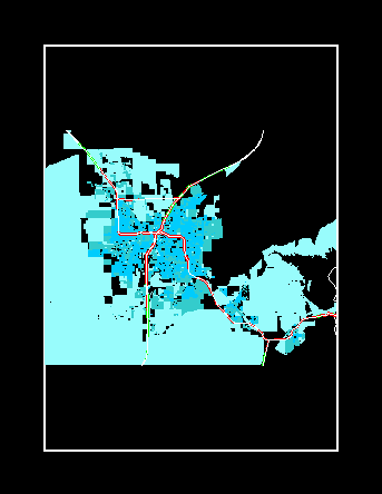
The County has a non-uniform population distribution as shown in Figure 3 (population density is expressed as persons/sq km). There are unpopulated areas, and areas with high concentration of population, especially within the Las Vegas metropolitan area. If one of the major roads is chosen to be the HLW and SNF route, the impact to population is evaluated using a impact distance of 0.5 mile on both sides of the roads. A 0.5 mile buffer is also shown in the figure.
Time is a critical factor in an emergency and the ability of the response unit to provide appropriate and timely response in an emergency will affect the magnitude of adverse impacts. Knowledge of the exact location of emergency response units would enable estimation of response time with respect to areas likely to be affected and would enable an effective deployment of emergency responders.
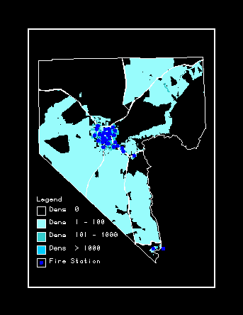
Twenty-eigth fire stations have been identified in Clark County. These operate under the jurisdiction of Clark County and the cities of Las Vegas, North Las Vegas, Henderson, and Boulder City. The location of these stations are shown in Figure 4 with respect to the Clark County major roads and population zones. As can be noted, most of the fire stations are located in metropolitan areas. There is a conspicuous absence of a response units along US 93, the segment of I-15 lying northeast and southwest of the metropolitan area, and the segment of US 95 lying southwest of the metropolitan area. The segment of I-15 lying southwest of the metropolitan area has a population density of less than 100.
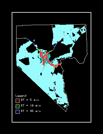
Route systems are developed to evaluate the service zones of each response unit for various ranges of response times, 5, 10 and 45 minutes. A response time of 5 minute is chosen because fire responders typically respond on an average of about 3 to 5 minutes. A 10-minute response window is recommended by the Federal Highway Administration for any point along the hazardous materials highway route. A 45 minute response time is tentatively chosen as a maximum for desired response time. For a given response time, each response unit, which serves as a center, was allocated to the network using travel time impedances. Travel time is estimated by assuming a travel speed of 55 mph for interstate highways, 45 mph for major arterials and 35 mph for all other roads. For each response unit, the allocation process created a route system showing the extent of the route as shown in Figure 5. This route system was used to define the service boundary of each response unit.
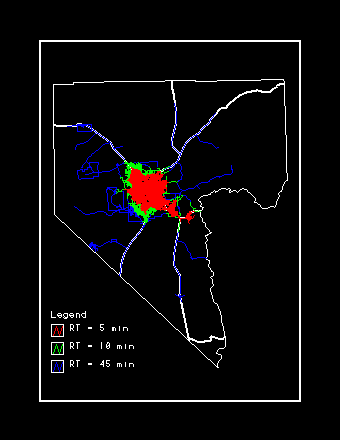
Critical segments, or those segments which cannot be served within a response time (RT) of 10 minutes are shown in Figure 6. Considering the FHA recommendation of 10-minute response time, Craig Road, and the segments of I-15, US 93, and US 95 within the metropolitan area and its adjacent areas can be served. Most of the populated segments of the major roads can be served within a response time of 45 minutes, except the northeastern portion of I-15 and the southern portion of US 93.
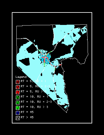
The segments of I-15, US 93 and US 95 have overlapping response units (RU) for a 10-minute response time especially within the metropolitan area (see Figures 7 and 8). The number of overlapping response units tends to decrease as the route segments move further from the metropolitan area.
Strong system and application tools are key components in evaluating emergency preparedness of a locality as illustrated by the use of GIS technology. The availability of emergency response information and spatial databases, facilitate analysis of response options to an event, identification of appropriate and timely actions to minimize potential impacts, and strategic positioning of future additional emergency response units. This paper also enables identification of critical segments of potential route. Various options can be evaluated concerning critical segments. These may include avoidance of the critical segment through rerouting, deploying of a response unit in the vicinity, or imposition of more strict rules regarding hazardous materials shipment along the critical segment.
Future extension to this work could include evaluation of the capability of the response unit, evacuation routing, determining the population that could potentially be affected by an event and the service population within the jurisdiction of a response unit.
Abkowitz, Mark, M. Lepofsky and P.D. Cheng. Selecting Criteria for Designating Hazardous Materials Highway Routes. Transportation Research Record 1333, TRB National Research Council. 1992. pp. 30-35.
Anders, C., and J. Olsten. GIS Risk Analysis of Hazardous Materials Transport. State and Local Issues in Transportation of Hazardous Materials: Towards a National Strategy. pp.248-261. 1990.
Environmental Systems Research Institute. ArcInfo User's Guide. Version 6.
U.S. Department of Transportation, Federal Highway Administration. Guidelines for Applying Criteria to Designate Routes for Transporting Hazardous Materials. September 1994.