David R. Fletcher, Thomas E. Henderson, and John Espinoza Jr.
David R. Fletcher, Geographic Paradigm Computing, Inc.
Thomas E. Henderson, New Mexico State Highway and Transportation Department
John Espinoza Jr., Sandia National Laboratories
This Pooled Fund Study - sponsored by the US Federal Highway Administration, the US Federal Transit Administration, Sandia National Laboratories, 41 US State and Canadian Provincial Departments of Transportation, the District of Columbia and nine private sector companies - is developing a comprehensive information framework supporting multi- jurisdictional, multi-modal transportation planning. This framework consists of a set of non-proprietary information models, system designs and prototype demonstrations incorporating the United States' Intermodal Surface Transportation Efficiency Act of 1991 (ISTEA) requirements for statewide and metropolitan transportation planning activities plus the requirements for seven management and monitoring systems: highway pavement, bridges, highway safety, traffic congestion, public transportation facilities and equipment, intermodal transportation facilities and systems and traffic monitoring for highways. These models provide organizational and technologically independent perspectives of these functional areas concentrating on providing a consensus based framework suitable for individual agency adaptation and modification. The USD $ 1.5 Million Study began in November 1993 and will conclude in October 1995. This paper provides an overview of the Study and discusses the results of the first Phase of the Study.
In 1992 the Alliance for Transportation Research, Albuquerque, New Mexico (ATR) and two of its member agencies - the New Mexico State Highway and Transportation Department and Sandia National Laboratories - proposed a comprehensive GIS-T research agenda outlining the requirements for the next generation of GIS-T technologies [COVER]. That proposal outlined a national effort to synthesize the new transportation policy as outlined in the Intermodal Surface Transportation Efficiency Act of 1991 (ISTEA) with the emerging server net based Geographic Information Systems concepts presented in NCHRP Report 359 [VONDEROHE]. After much consultation with Federal and State interests, a project proposal based on the ATR concept was developed and eventually resulted in this Pooled Fund Study. As of August 1994, the US Federal Highway Administration, the US Federal Transit Administration, Sandia National Laboratories, 41 US State and Canadian Provincial Departments of Transportation, the District of Columbia and nine private sector firms and consortia are co-sponsoring this 18 month USD $ 1.5 Million Study. The Study began in November 1993 and will conclude in October 1995.
This purpose of this Study is to develop and demonstrate an integrated approach to transportation planning activities, information and technologies. This objective can be further defined to:
1. Develop a system architecture for a Geographic Information System - Transportation (GIS-T) which can be used in support of the multi-jurisdictional, intermodal transportation facilities planning and management systems requirements for pavement, bridge, safety, congestion, public transportation and intermodal management as well as traffic monitoring and clean air monitoring activities.
This architecture will consist of a set of public domain activity, data and systems models of transportation planning and project selection functions. These models will provide an institutional and technologically independent perspective suitable for individual agency adaptation and modification.
2. Encourage the development of functional GIS-T server net prototypes. These prototypes will be developed by the private sector partners sponsoring this study. This encouragement will result from a series of research transfer activities between the study and the private sector.
3. Demonstrate the design, implementation and operation of multiple transportation planning systems in a server net environment.
4. Develop and incorporate new capabilities into the core GIS-T architecture as necessary. These may include new models, processes or technologies.
The Study is subdivided into three distinct, interrelated research phases. Each phase emphasizes a different aspect to the research: (A) enterprise modeling, (B) information systems analysis and preliminary design and (C) technology demonstration. As of April 1995, Phase A and Phase B are complete.
Phase A focused on defining the goals, strategies, information needs, activities and data necessary for comprehensive transportation planning. Because this enterprise view was crucial to the success of the Study, the Study Steering Committee decided that the information systems framework should be determined by a team of representatives from the sponsoring agencies. As a result, a solicitation was prepared and distributed to the participating States in December 1993. The eleven members of Team A were selected in January 1994 and represented eight State Departments of Transportation, and one Metropolitan Planning Organization. This technical team developed the enterprise model in five, week- long working sessions during January - May 1994. The results of this Phase were documented and accepted by the Study Steering Committee in June 1994.
The information framework developed in Phase A provides a high level view of the activities, data, and business systems necessary for multi-jurisdictional, multi-modal transportation planning. Although this framework is consistent with US regulations, it can be used by any transportation planning authority. This policy driven framework provides a mechanism to coordinate all aspects of transportation planning. It creates the groundwork for more detailed analysis and information systems development to be conducted by individual agencies, the private sector and subsequent phases of the Study. The framework can also be used to develop management system work plans, coordinate business process reengineering and Total Quality Management activities, provide a strategic environment for information technology planning and foster the development of transportation planning data sharing standards. The framework is inherently flexible and can be adapted to a wide range of individual implementation and operational choices across all organizations involved in transportation planning activities.
The Activity model defines transportation planning functions decomposed into lower level processes. These activities include the determination of transportation policies and objectives, the identification of transportation needs, the identification of resources and funds, and the development of long range transportation plans and treatment strategies. Activities associated with financial management, including operational and transportation program budget development and monitoring functions are not included in this analysis.
The activities in this model describe specific information transformations in a non-procedural, non- institutional way. That is, the emphasis is on WHAT the work is and not on who performs it or how it is done. Many of the activities included in the model are envisioned to be multi-participatory; many of the activities are also assumed to be manual (i.e., not able to be easily automated). However, the model does not include institutional impacts due to the idiosyncratic nature of transportation planning organizations.
The Team recognized that the transportation planning function is conducted by many different people, including elected officials, agency managers, transportation planners and engineers. The role of the policy makers is to set directions and allocate resources. The role of the transportation professional is to provide the best technical advice to the policy maker and to carry out the transportation plans adopted through the political process. The team felt that effective transportation planning depends on a more coordinated relationship between these two groups. This model provides formal documentation of a policy driven planning process encompassing the information needed by these two camps.
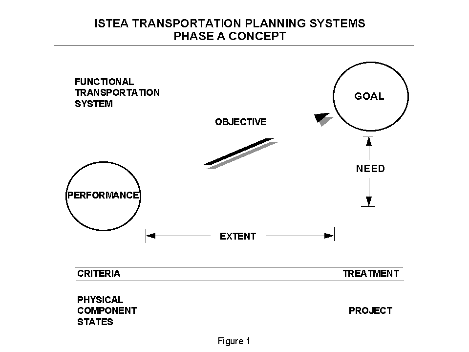
A conceptual flow chart relating the elements incorporated in this analysis has been developed (Figure 1). The underlying logic of this analysis is as follows:
1. Transportation policies are developed in response to economic, environmental, institutional, political and other factors influencing transportation. These policies, although not shown in the figure, provide the overall demands and constraints concerning transportation.
2. OBJECTIVES are defined, consistent with these policies, identifying FUNCTIONAL requirements for transportation facilities and services that can be satisfied with special purpose TRANSPORTATION SYSTEMS comprised of TRANSPORTATION SYSTEM COMPONENTS.
3. GOALS can be set for each OBJECTIVE, establishing where and when each FUNCTION needs to be available.
4. CRITERIA to assess the PERFORMANCE of each SYSTEM are identified where each CRITERION transforms the physical or operational STATE of a TRANSPORTATION SYSTEM COMPONENT into PERFORMANCE.
5. NEED is defined as the difference between the PERFORMANCE of a TRANSPORTATION SYSTEM and the GOAL established for that SYSTEM.
6. TREATMENTS are actions that will improve the PERFORMANCE of a SYSTEM.
7. PROJECTS are combinations of TREATMENTS that alter the state of TRANSPORTATION SYSTEM COMPONENTS.
The data model contains high level data entity types necessary to support the integrated activity model. The data model does not contain specific inventory, condition or operational attributes, reflecting the latitude that local agencies have in this area. Although many of the entity types in the model are geographic (i.e., have location as an attribute), they have not been decomposed into spatial entity types (e.g., points, lines, polygons or routes). Also, none of the various location reference methods have been explicitly modeled (e.g., geodetic, geographic or linear references). As a result, this model is applicable across agencies regardless of their GIS-T status. The data model has been expanded in Phase B to include the appropriate spatial detail.
The Transportation Planning Business Systems represent the logical groupings of the previously discussed activities and data based on their natural affinities. These Business Systems provide a framework to develop integrated information systems in support of the currently defined management systems as well as additional ones which may be required in the future.
The business systems model consists of an interaction analysis showing the effects of activities on data plus an affinity analysis used to determine the boundaries of an integrated set of natural business systems encompassing transportation planning. This framework contains six natural systems combined into a single integrated architecture. The following natural business systems descriptions refer to the business systems diagram (Figure 2).
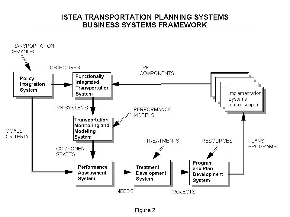
The intention of the ISTEA is that transportation planning be a policy driven process reflecting local, regional, statewide, national and international requirements and concerns. The Policy Integration System distills public values, visions and mandates concerning transportation into a set of specific, concrete policies, objectives and goals concerning the availability, quality and performance of transportation facilities and related services. The Policy Integration System determines the performance indicators necessary to establish and monitor transportation and sets the performance criteria necessary to assess the quality of transportation from multiple perspectives.
Specific activities included in this business system are intended to encompass those political and public involvement processes producing transportation policies, objectives and goals. Since policy formulation is, by definition, a nonprocedural political process conducted by elected officials, agency managers, special interest groups and the public, this business system may not be appropriate for subsequent information systems development.
The FITS system manages the inventory of all transportation facilities and services, where these components are functionally, geographically and temporally related. These facilities and services are organized into unique, dedicated systems delivering specific transportation services (e.g., traffic carrying, load bearing, employer access, farm-to-market access, asset service life, etc.) in response to social policies, objectives and goals. Each of these transportation systems experiences current and projected demand for services; each is affected by this demand. The FITS system manages both the demand for service and the performance of the systems responding to this demand.
The Transportation Monitoring and Modeling System determines the value of each performance indicator for each of the transportation component states, where states refer to a specific physical or operational condition of being. Values for states may be obtained by monitoring, modeling or simulation methods. Component state attributes must contribute directly to one or more functional assessments to be valid. Even though TRAMMS is modeled as one business system, each of the component monitoring processes may be designed as a separate system.
The Performance Assessment System determines the functional effectiveness, or performance, of each transportation component and each transportation system based on transportation demand, projected condition or operational state and associated performance criteria. The overall transportation system need is projected as the difference between system goals and current or projected performance.
The Treatment Development System associates performance needs with underlying causes and thereby to appropriate system and component level treatments. Effective system strategies are then developed based on an evaluation of past treatments as well as expected life cycle costs and benefits. Treatment strategies are synthesized into project concepts, reconciling all treatment alternatives.
The Planning and Programming Development System evaluates the effectiveness of each project concept based on its performance balanced against its environmental, social and economic effects. Selected projects are financed and incorporated into regional and statewide transportation plans and programs. This business system includes approval activities which are inextricably linked to the political decision making process. These processes may not be suitable for further automation support due to their nature.
Implementation systems encompass all business systems necessary to administer transportation programs and to develop and maintain transportation components - including engineering, construction and maintenance systems. The processes and data involved with these systems were not included in this analysis. The systems are shown in the architecture to illustrate the feedback mechanism necessary to administer work programs and to evaluate the effectiveness of implementing transportation plans and programs.
In conclusion, this Transportation Planning Business Systems Architecture represents an integrated, non-redundant, comprehensive approach to transportation planning. The framework offers several features that have enterprise, operational and technological implications. Each of these impacts will need to be explored on an individual basis.
Among the transportation planning enterprise features are the explicit recognition that transportation, social, and environmental policies must be reconciled at the front end of the transportation planning process. The architecture also establishes a basis for multi-jurisdictional cooperation and participation and also provides opportunities for public involvement at every level.
Equally important are the operational implications of this model. By focusing data collection and use on relevant data only, data management costs should decline from their present levels. The framework is also flexible enough to incorporate life cycle costing and other optimization strategies as they are developed or improved over time.
Finally, because the model emphasizes the information products used in planning without specifying how these products are to be created, the model is independent of any particular technology. This allows for incorporation of existing management systems and technologies as well as for incremental enhancement of existing technologies. In fact the entire architecture may be implemented manually with no change to the framework itself.
Business System (Natural Business System) - A logical grouping of business activities which forms the basis for subsequent information systems development. Source: "A Guide to Information Engineering Using the IEF;" Texas Instruments, 1988.
Framework - An enterprise-wide information architecture consisting of formal models of data, activity and their interactions.
Information Engineering - The enterprise-wide application of a formal and structured methodology for defining and implementing information systems which derive directly from the objectives of the enterprise. Source: James Martin.
Information System - The combination of Information Technology, data, business procedures and people applied to a business function, process or activity.
Information Technology - Computer hardware, software and technical staff necessary to develop, implement, maintain and operate information systems.
Management System - A systematic process, designed to assist decision makers in selecting cost-effective strategies/actions to improve the efficiency and safety of, and protect the investment in, the nation's infrastructure. A management system includes: Identification of performance measures; data collection and analysis; determination of needs, evaluation and selection of appropriate strategies/actions to address the needs, and evaluation of the effectiveness of the implemented strategies/actions. Source: DOT 49 CFR Part 614 Management and Monitoring Systems; Interim Final Rule.
Portions of this paper have been extracted from GIS-T ISTEA Management Systems Server-Net Prototype Pooled Fund Study documents, including the Project Plan and Proposal and the PHASE A SUMMARY Report. The Authors acknowledge the contributions of Mr. Robert K. Cover, Sandia National Laboratories, Co-Principal Investigator 1993-1995.
Cover, R.; Fletcher, D.; Henderson, T.; (1993) "Transportation and Geographic Computing Concept;" Alliance for Transportation Research; 24 pp.
Vonderohe, A. P.; Travis, L., Smith, R. L.; Tsai, V.; (1993) "Adaptation of Geographic Information Systems for Transportation;" National Cooperative Highway Research Program Report 359, National Academy Press; 69 pp.