GIS would seem to be a natural tool for geologists doing basic geologic mapping. Computer tools have been used for decades to allow geologists to utilize remotely-sensed geophysical data such as magnetic or gravity anomaly data or seismic data as aids in developing a geologic interpretation of an area. The use of computer tools in the management and utilization of basic field mapping data - structural measurements, hand sample location and outcrop mapping - and associated geochemical information has lagged behind. In general, this is because of the complexity and subjective nature of the information, the varied quality of the data, the often non-systematic way it is collected, and, until recently, the unavailability of inexpensive and adequate GIS tools. This paper describes a prototype system developed using ArcInfo to collect, manage, and manipulate field data for bedrock geologic mapping in a largely igneous terrane.
A great deal of work has been done using computers for viewing or visualizing sensed geologic data - magnetic or gravity anomaly, or seismic data, and GIS has been readily applied to the cartographic aspects of geologic mapping. There are also many studies utilizing statistical techniques to generalize point data as an aid in geologic interpretation. Little work, however, has been done using GIS to facilitate the use of geologic field data in an otherwise traditional approach to geologic mapping. This study focuses on implementing GIS as a tool for organizing, assembling, and interpreting geologic data - in particular field observations, measurements, and sample data - with emphasis on large scale (1:24,000 scale quadrangle) field mapping. In our experience, GIS tends to be applied late in the process of geologic mapping, if at all. The Minnesota Geological Survey [MGS] is attempting to develop the tools necessary to allow GIS to be used by the geologist from the beginning of a mapping project through to final map creation.
Two major constraints were accepted at the beginning of this effort. The first was that the learning curve of ArcInfo was too steep to expect geologists in general to utilize ARC as a tool without the implementation of a higher-level interface, that is a system of amls. The second was that geologic field mapping is a very broad and subjective field. Therefore the system developed was focused on a specific geologic terrane and modeled on the mapping style of one geologist.
The terrane for this study consisted of intrusive igneous rocks of the Beaver Bay Complex, the basalts of the North Shore Volcanic Group, and intrusive rocks of the Duluth Complex, all associated with the Midcontinent rift in northeastern Minnesota. This permitted development of the system without dealing with the complexities of other broad geologic terranes - metamorphic, sedimentary, Quaternary, or mixed. We approached this as a pilot project with the hopes that the system developed could be readily expanded or adapted to apply to mapping in these other areas.
Consideration was given to the idea of using field units with GPS to capture field data directly into the GIS. Some experimentation was done using a GPS unit with a real-time display over a scanned quad image. The ultimate goal would be a pen-based unit with real-time corrected GPS, incorporating the type of user interface that we are working toward here. However, the rigors of field mapping (10 to 12-hour days in remote, rugged areas) are beyond the current capabilities of commercial pen-based GPS units, not to mention the problem of a suitable interface.
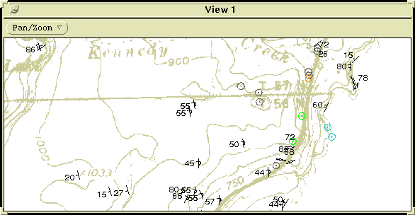
The purpose, then, of the project was to use GIS as a tool for geologic interpretation, as a data archive library, and as a cartographic method. The challenges were 1) getting ARC into the hands of the geologist without the learning curve, and 2) designing a system that is suited to the iterative processing and manipulation of geologic, structural, geochemical, and geophysical data that goes into the subjective creation of a geologic map. The result is GeMS (Geologic Mapping System), a GIS consisting of an aml-based graphical interface with image/grid base layers and data structures for storing and manipulating geologic field and analytic data, with the capability for generating mapped output. Figure 2 below is an example of field data as compiled using GeMS.
Part of the purpose of the system is to provide all the functionality of traditional geologic mapping, and more, through GIS. An essential item for field mapping is a topographic base map - in many cases, a U.S. Geological Survey 1:24,000 topographic quadrangle map. The system design involved using scanned images of quadrangle maps as bases for on-screen entry and editing of field data and outcrop locations and drawing geologic contacts. No attempt was made to include every element of field data within the data base. Field notes, photographs, micro graphs and the like are indexed within the system but not included in toto. The system was also designed to include existing or auxiliary data in addition to the field and analytic data. This included gridded aeromagnetic anomaly and bouguer gravity data. A further goal of the system design was to provide an interface such that a generally computer literate geologist could work at the computer with little training or guidance.
It should be kept in mind that this design is for a system dealing with a largely igneous terrane and therefore addresses only intrusive and volcanic rocks. Additional data structures and procedures must be developed to handle the specifics of other rock types and structural regimes.
database	type	description

GMSSAM	  point cov.	field sample data base

GMSWRA	  info file	whole rock analyses data base

GMSPRB	  info file	microprobe analyses data base

[GMSISO]  info file	isotopic analyses data base
[GMSASS]  info file	assay data base
[GMSGCH]  info file	geochronology data base
GMSSTR	  point cov.	structural measurement database
GMSSTRAxx point cov.	structural meas. annotation
GMSOC	  polygon cov.	outcrop data base
OCIIN	  info file	Igneous, INtrusive attribute data base
OCIVO	  info file	Igneous, VOlcanic attribute data base
[OCSED]	  info file	SEDimentary rocks attribute data base
[OCMET]	  info file	METamorphic rocks attribute data base
GMSGPxx	  polygon cov.	interpreted geologic units/map
GMSGLxx	  line cov.	interpreted geology - structure

MNMAG	  grid		aeromagnetic anomaly
MNGRAV	  grid		bouguer gravity anomaly
MNDEM	  grid		DEM (1:250,000); to use 1:24,000 when available
Qxxx/topo.tif TIFF 	7.5' quad image; DRGs to be used when available

[data struct] - indicates not yet developed

Brief definitions of data structures without listing specific attributes of each
structure:

GMSSAM: contains the location of field sites and basic attribute data
   including date, geologist(s), notebook and map indices, map unit, field
   description, and flags for samples and analytic data.
GMSWRA: a GMSSAM-related data base of whole rock analysis from
   samples taken at the specified field site
GMSPRB : a GMSSAM-related data base of microprobe analyses from
   samples taken at specified field site

GMSSTR:  contains location of field structural measurements and attribute
   data.  This includes data represented by strike and dip or trend and plunge
   and represents one of the interesting challenges, from a GIS standpoint, of
   the system.  Amls were developed to symbolize different structural
   measurements adjusting the orientation of the symbol and placement of
   measured vales based on attributes in the coverage pat file.
GMSSTRAxx: symbolization layer for GMSSTR.  Used for generating
   appropriately oriented symbols for measurements in GMSSTR.
   Automatically generated from attributes and locations in GMSSTR.

GMSOC: outcrop polygons and general attributes including geologist, date,
   quality of exposure, outcrop type, rock type(s), alteration and
   mineralization, plus references to notebook, field map, and photos.
OCIIN: a GMSOC-related data file of extended attribute information for
   intrusive igneous rocks; includes rock name(s), mineralogy, texture,
   layering, grain size, and chrono-stratigraphic interpretation.
OCIVO: a GMSOC-related data base of extended attribute information for
   volcanic rocks; includes type, composition, color, composition, grain size,
   phenocryst mineralogy, flow top and flow base morphology, planar and
   non-planar structural features, description of vesicles and amygdules, and
   chrono-stratigraphic interpretation.

GMSGPxx: interpreted geology (contacts and geologic units)
GMSGLxx: interpreted linear geologic features such as faults and fold axes.

MNMAG: statewide magnetic anomaly grid from high resolution
   aeromagnetic survey (Chandler, 1991).  Grid interval: 213.36m.  This data
   as well as MNGRAV are typically filtered when used as an aid to geologic
   interpretation.  ARC utilities to provide easy handling of this data is
   under development.
MNGRAV: statewide bouguer anomaly grid (Chandler & Schaap, 1991).
   This data is somewhat too coarse for mapping at 7.5' quad scale but is useful
   in setting the regional context.
MNDEM: statewide 1:250,000 DEM data assembled from USGS  1-Degree
   Digital Elevation Model data (U.S. Geological Survey, 1990) and
   resampled to a UTM projection with a grid interval of about 93m.  This data
   is not detailed enough for quad scale mapping but helps to visualize the
   general topographic setting.

Qxxx/topo.tif: scanned USGS 7.5' quadrangle maps.  Will use USGS DRG
   (Digital Raster Graphic) scanned quads when available since scanning and
   registration is more accurate.
The software, consisting of ARC amls, continues to evolve but is represented conceptually in the chart below (figure 3). Extensive use was made of aml threads and cursor handling for the related data tables.
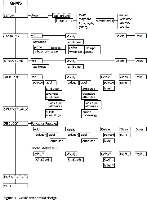
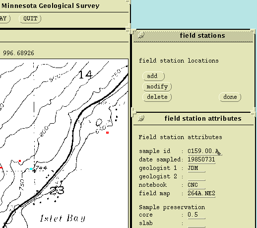
The shaded areas above indicate modules yet to be developed. In the implementation, provisions were made in the attribute entry modules to default fields to the data for the previous site. This eases the data entry burden since many of the attributes, such as geologist, date, field notebook and map, will be the same for a large number of field sites. A sample of the user interface as implemented is shown in figure 4 below.
USGS 1:24,000 topographic maps on film were scanned at 300 dpi, rectified using ARC and stored as TIFF files. The negatives of the quads were originally produced for other purposes and some of them were 2X enlargements from 1:62,500 quadrangles. Though the topography on the enlarged quads was superior to that on later 1:24,000 quads of the same area, the registration of the images left something to be desired. Similar problems were encountered with some of the 1:24,000 negatives since they occasionally did not include all the latitude/longitude points needed for rectification.
Outcrop areas had been inked in on quad bases and these were also scanned. The scanned images were converted to grids and then to polygon coverages. This process worked fairly well. Although there was occasionally some discrepancy between the quad base and the outcrop polygons since the images were rectified separately from different scans, the edit feature in the GeMS outcrop module allowed easy repositioning of the polygons.
Existing magnetic and gravity anomaly data were converted from ASCII files for use as background images in the system.
Field station and structural measurement locations and attributes were captured interactively using the system although existing whole rock and microprobe data were converted from Macintosh Excel files.
A general GIS geologic mapping system will be complex. This study presents a general design and implementation for part of such a system and addresses or explores some of the difficulties involved, notably the storage and handling within ArcInfo of structural field measurements involving oriented symbols at a point location. Additional work is needed to develop tools to operate on data stored in the system and present it as ancillary data to aid geologic interpretation. Ongoing development will also extend the system for use in other geologic environments.
The system presented relies on digital images of USGS 7.5' topographic maps as base maps, or background images. The desired implementation of this prototype system would utilize the new DRGs or Digital Raster Graphic scanned quads developed by the USGS when they become available. Although desirable, a pen-based, real-time corrected GPS system for use in the field with a tailored interface for geologic mapping is yet some time distant.
It is clear from this study that close cooperation between geologists and GIS developers is essential and that, although the system must be developed as much as possible to respond to the geologists' mapping styles, the geologists will modify their field methods to some extent as they become familiar with the capabilities and constraints of GIS.
Chandler. Val W., 1991, Aeromagnetic anomaly map of Minnesota: Minnesota Geological Survey State Map Series S-17, scale 1:500,000.
Chandler, Val W. and Schaap, Bryan D., 1991, Bouguer gravity anomaly map of Minnesota: Minnesota Geological Survey State Map Series S-16, scale 1:500,000.
Environmental Systems Research Institute, Inc., 1992, AML User's Guide: Environmental Systems Research Institute, Inc.
Miller, James D. Jr., Wahl, Timothy E., and Bauer, Emily A., 1994, Digitization of geologic data from the 1985-1993 COGEOMAP program area, Minnesota: Minnesota Geological Survey Open-file Report 94-5.
San Diego Supercomputer Center, 1992, SDSC Image Tools: San Diego Supercomputer Center.
U.S. GeoData, 1990, Digital elevation models: data users guide 5: U.S. Geological Survey.
US GeoData, 1994, Product Development Report, Digital Raster Graphic (DRG) Data: U.S. Geological Survey.